• FluTrackers.com Inc. does not provide medical advice. Information on this web site is collected from various internet resources, and the FluTrackers board of directors makes no warranty to the safety, efficacy, correctness or completeness of the information posted on this site by any author or poster. The information collated here is for instructional and/or discussion purposes only and is NOT intended to diagnose or treat any disease, illness, or other medical condition. Every individual reader or poster should seek advice from their personal physician/healthcare practitioner before considering or using any interventions that are discussed on this website. By continuing to access this website you agree to consult your personal physican before using any interventions posted on this website, and you agree to hold harmless FluTrackers.com Inc., the board of directors, the members, and all authors and posters for any effects from use of any medication, supplement, vitamin or other substance, device, intervention, etc. mentioned in posts on this website, or other internet venues referenced in posts on this website.
  • We are not asking for any donations. Do not donate to any entity who says they are raising funds for us.

Japan - Major Earthquake Magnitude 9.0 on Mar 11, Sanriku Oki (7.2 on March 9) - Official number of dead and missing 28,000+ - March 8 - March 26

Re: Japan - Magnitude 7.2 Sanriku Oki

Re: Japan - Magnitude 7.2 Sanriku Oki

Update time = Fri Mar 11 07:35:58 UTC 2011


MAP 5.8 2011/03/11 07:10:59 37.899 142.734 30.0 OFF THE EAST COAST OF HONSHU, JAPAN
MAP 6.3 2011/03/11 06:57:14 35.758 140.992 30.2 NEAR THE EAST COAST OF HONSHU, JAPAN
MAP 6.3 2011/03/11 06:48:47 37.993 142.764 22.3 OFF THE EAST COAST OF HONSHU, JAPAN
MAP 7.1 2011/03/11 06:25:50 38.106 144.553 19.7 OFF THE EAST COAST OF HONSHU, JAPAN
MAP 6.8 2011/03/11 06:15:45 36.126 140.234 30.2 NEAR THE EAST COAST OF HONSHU, JAPAN
MAP 6.4 2011/03/11 06:07:21 36.401 141.862 35.4 NEAR THE EAST COAST OF HONSHU, JAPAN
MAP 6.4 2011/03/11 06:06:11 39.025 142.316 25.1 NEAR THE EAST COAST OF HONSHU, JAPAN
MAP 8.9 2011/03/11 05:46:23 38.322 142.369 24.4 NEAR THE EAST COAST OF HONSHU, JAPAN
MAP 4.9 2011/03/10 22:44:25 38.844 143.006 34.2 OFF THE EAST COAST OF HONSHU, JAPAN
MAP 4.7 2011/03/10 21:49:46 38.590 143.086 26.0 OFF THE EAST COAST OF HONSHU, JAPAN
MAP 5.2 2011/03/10 16:54:45 38.053 143.253 4.7 OFF THE EAST COAST OF HONSHU, JAPAN
MAP 5.1 2011/03/10 11:21:08 38.611 143.049 17.6 OFF THE EAST COAST OF HONSHU, JAPAN
MAP 5.2 2011/03/10 09:02:21 38.652 143.146 21.9 OFF THE EAST COAST OF HONSHU, JAPAN
MAP 4.8 2011/03/10 08:59:19 38.547 143.295 19.8 OFF THE EAST COAST OF HONSHU, JAPAN
MAP 5.7 2011/03/10 08:08:20 38.630 143.304 17.2 OFF THE EAST COAST OF HONSHU, JAPAN
MAP 4.8 2011/03/10 07:33:04 38.954 142.458 20.0 NEAR THE EAST COAST OF HONSHU, JAPAN
MAP 4.6 2011/03/10 04:14:00 38.406 143.427 31.0 OFF THE EAST COAST OF HONSHU, JAPAN
MAP 5.0 2011/03/10 01:20:23 38.408 143.033 25.1 OFF THE EAST COAST OF HONSHU, JAPAN
MAP 4.8 2011/03/09 23:57:41 38.308 143.275 20.0 OFF THE EAST COAST OF HONSHU, JAPAN
MAP 5.4 2011/03/09 23:37:00 38.438 143.185 32.8 OFF THE EAST COAST OF HONSHU, JAPAN
MAP 6.1 2011/03/09 21:22:18 38.385 142.642 23.0 NEAR THE EAST COAST OF HONSHU, JAPAN
MAP 4.9 2011/03/09 21:00:57 38.267 142.580 22.5 NEAR THE EAST COAST OF HONSHU, JAPAN
MAP 6.0 2011/03/09 18:44:35 38.502 143.199 23.0 OFF THE EAST COAST OF HONSHU, JAPAN
MAP 6.1 2011/03/09 18:16:14 38.378 142.506 22.0 NEAR THE EAST COAST OF HONSHU, JAPAN
MAP 4.8 2011/03/09 14:24:05 38.589 143.226 10.0 OFF THE EAST COAST OF HONSHU, JAPAN
MAP 4.7 2011/03/09 12:03:17 38.358 143.119 13.1 OFF THE EAST COAST OF HONSHU, JAPAN
MAP 5.1 2011/03/09 11:27:51 38.529 143.040 28.2 OFF THE EAST COAST OF HONSHU, JAPAN
MAP 4.7 2011/03/09 10:13:39 38.721 143.090 27.2 OFF THE EAST COAST OF HONSHU, JAPAN
MAP 4.8 2011/03/09 08:55:38 38.667 143.055 15.6 OFF THE EAST COAST OF HONSHU, JAPAN
MAP 5.3 2011/03/09 08:02:36 38.606 143.103 15.4 OFF THE EAST COAST OF HONSHU, JAPAN
MAP 5.1 2011/03/09 07:56:27 38.849 142.929 10.7 NEAR THE EAST COAST OF HONSHU, JAPAN
MAP 5.0 2011/03/09 07:13:48 38.246 143.108 9.9 OFF THE EAST COAST OF HONSHU, JAPAN
MAP 5.1 2011/03/09 06:25:12 38.299 143.067 10.8 OFF THE EAST COAST OF HONSHU, JAPAN
MAP 4.9 2011/03/09 06:12:13 38.681 143.022 10.0 OFF THE EAST COAST OF HONSHU, JAPAN
MAP 5.3 2011/03/09 04:45:54 38.543 142.740 27.0 NEAR THE EAST COAST OF HONSHU, JAPAN
MAP 5.7 2011/03/09 04:37:03 38.666 142.991 25.5 NEAR THE EAST COAST OF HONSHU, JAPAN
MAP 5.2 2011/03/09 04:32:10 38.727 143.001 32.1 OFF THE EAST COAST OF HONSHU, JAPAN
MAP 4.8 2011/03/09 04:15:39 38.857 142.658 12.6 NEAR THE EAST COAST OF HONSHU, JAPAN
MAP 5.2 2011/03/09 04:05:53 38.870 142.420 10.9 NEAR THE EAST COAST OF HONSHU, JAPAN
MAP 5.0 2011/03/09 03:19:00 38.795 142.962 19.9 NEAR THE EAST COAST OF HONSHU, JAPAN
MAP 5.2 2011/03/09 03:08:35 38.339 143.097 24.4 OFF THE EAST COAST OF HONSHU, JAPAN
MAP 5.6 2011/03/09 02:57:16 38.402 142.825 17.5 NEAR THE EAST COAST OF HONSHU, JAPAN
MAP 7.2 2011/03/09 02:45:20 38.424 142.836 32.0 NEAR THE EAST COAST OF HONSHU, JAPAN


http://earthquake.usgs.gov/earthquakes/recenteqsww/Maps/10/140_35_eqs.php

.
 
Re: Japan - Magnitude 7.2 Sanriku Oki

Re: Japan - Magnitude 7.2 Sanriku Oki

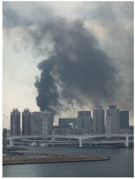
attachment.php
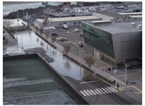
odaiba, tokyo
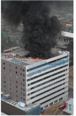
attachment.php
kôtô ward, tokyo
attachment.php
chiyoda ward, tokyo

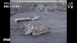
tsunamis
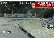
attachment.php
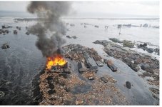
miyako city, iwate
attachment.php
onagawa town, miyagi

photo mainichi jp

Many lives were lost in the Earthquake
 

Attachments

  • snap20110311162818.jpg
    snap20110311162818.jpg
    38.9 KB · Views: 0
  • snap20110311163737.jpg
    snap20110311163737.jpg
    58.4 KB · Views: 0
  • snap20110311163954.jpg
    snap20110311163954.jpg
    62.7 KB · Views: 0
  • snap20110311163651.jpg
    snap20110311163651.jpg
    70.3 KB · Views: 0
  • snap20110311163702.jpg
    snap20110311163702.jpg
    59 KB · Views: 0
Re: Japan - Magnitude 7.2 Sanriku Oki

Re: Japan - Magnitude 7.2 Sanriku Oki

This quake had a very different pattern on distant (here in AK) seismographs that what I saw in the earlier Japan EQ and most others. It actually had a "build up" in vibrations, rather that the usual sudden large spikes of the P wave, and it had a long series of waves afterward. I'm assuming those are what we used to call "L" waves.

This must have been quite the quake to keep the earth shaking so much for so long after the first shock, prior to any second shock.

The webicorder below is from Mt. Iliamna (near Anchorage). There is about a 10 minute delay in the waves from Japan to this site, so you'll see it arriving at 5:55 UTC. The next Japan wave doesn't arrive until about 6:24 UTC. Note the continuing shaking during that intervening 30 minutes.

japan 8.9.JPG

If you want to look at other seismographs (aka webicorders) see: http://www.avo.alaska.edu/webicorders/Iliamna/

Keep in mind that the sensitivity settings are not consistant, as it pertains to the needs of any one volcano.

.
 
Re: Japan - Magnitude 7.2 Sanriku Oki

Re: Japan - Magnitude 7.2 Sanriku Oki

The seismograph I showed is 3364 miles away from the Japan 6.9 earthquake.

.
 
Re: Japan - Magnitude 7.2 Sanriku Oki (& 8.9 on 3/11) - Tsunami warning

Re: Japan - Magnitude 7.2 Sanriku Oki (& 8.9 on 3/11) - Tsunami warning

Pacific wide Tsunami warnings are now being issued across the entire pacific in the wake of the 8.9 earthquake off the coast of Honshu. T


Tsunami waves in excess of 7 meters have now been reported in Northern Japan.


A TSUNAMI WARNING IS IN EFFECT FOR:


JAPAN / RUSSIA / MARCUS IS. / N. MARIANAS / GUAM / WAKE IS. / TAIWAN / YAP / PHILIPPINES / MARSHALL IS. / BELAU / MIDWAY IS. / POHNPEI / CHUUK / KOSRAE / INDONESIA / PAPUA NEW GUINEA / NAURU / JOHNSTON IS. / SOLOMON IS. / KIRIBATI / HOWLAND-BAKER / HAWAII / TUVALU / PALMYRA IS. / VANUATU / TOKELAU / JARVIS IS. / WALLIS-FUTUNA / SAMOA / AMERICAN SAMOA / COOK ISLANDS / NIUE / AUSTRALIA / FIJI / NEW CALEDONIA / TONGA / MEXICO / KERMADEC IS / FR. POLYNESIA / NEW ZEALAND / PITCAIRN / GUATEMALA / EL SALVADOR / COSTA RICA / NICARAGUA / ANTARCTICA / PANAMA / HONDURAS / CHILE / ECUADOR / COLOMBIA / PERU

http://afludiary.blogspot.com/2011/03/pacific-wide-tsunami-warnings.html


m1gz0rpabdjc_700.jpg


m1gz0roavgj7_700.jpg


m1gz0roasrhi_700.jpg


m1gz0roaohhy_700.jpg


m1gz0riarvfw_700.jpg


m1gz0roachia_700.jpg
 
Re: Japan - Magnitude 7.2 Sanriku Oki (& 8.9 on March 11) - Tsunami warning

Re: Japan - Magnitude 7.2 Sanriku Oki (& 8.9 on March 11) - Tsunami warning

10 minutes ago the north pacific tsunami warning center said no warnings, then this just came out:

To: U.S. West Coast, Alaska, and British Columbia coastal regions
From: NOAA/NWS/West Coast and Alaska Tsunami Warning Center
Subject: Tsunami Watch and Advisory #3 issued 03/10/2011 at 11:33PM PST

UPDATED MAGNITUDE TO 8.8

The Tsunami Advisory continues in effect for the coastal areas of Alaska from Chignik Bay, Alaska to Attu, Alaska.

The Tsunami Watch continues in effect for the coastal areas of California, Oregon, Washington, British Columbia and Alaska from the California-Mexico border to Chignik Bay, Alaska.

(little note below was added)

Measurements of reports of tsunami activity:

TSUNAMI OBSERVED ON DEEP OCEAN BUOY
UPGRADED MAGNITUDE TO 8.8

http://wcatwc.arh.noaa.gov/2011/03/11/lhvpd9/03/messagelhvpd9-03.htm
__________________________________________________

The waves should reach Shemya island, here in AK long before they reach Califonia, etc. and there are sensors there that will measure any tsunami.

.
 
Re: Japan - Magnitude 7.2 Sanriku Oki (& 8.9 on March 11) - Tsunami warning

Re: Japan - Magnitude 7.2 Sanriku Oki (& 8.9 on March 11) - Tsunami warning

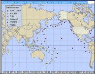
This shows all the bouys in the Pacific that measure wave height. If you go the the actual site & hover over a point, you can see the current wave data points. You can SEE the tsunami traveling!

Capture.JPG

http://www.ndbc.noaa.gov/dart.shtml

.
 
Re: Japan - Magnitude 7.2 Sanriku Oki (& 8.9 on March 11) - Tsunami warning

Re: Japan - Magnitude 7.2 Sanriku Oki (& 8.9 on March 11) - Tsunami warning

The tsunami waves show as additional points immediately above and below the normal waves lines. As I read it right now, the bouy east of Kamchatka is showing a 30 meter increse (sure hope that's wrong), with the new wave points at 5770 meters. The point ESE of Japan isn't showing points as high. I would assume bouys at Shemya (station 21415) and Attu (station 21414) - (1st 2 on west end of Aleutian Islands) will give a good portrait of the waves actual size.

.
 
Re: Japan - Magnitude 7.2 Sanriku Oki (& 8.9 on March 11) - Tsunami warning

Re: Japan - Magnitude 7.2 Sanriku Oki (& 8.9 on March 11) - Tsunami warning

The bouy at station 52402 (between Japan and PNG, a little to the ESE) is showing new points, however they aren't as high as the waves going north).

.
 
Re: Japan - Magnitude 7.2 Sanriku Oki (& 8.9 on March 11) - Tsunami warning

Re: Japan - Magnitude 7.2 Sanriku Oki (& 8.9 on March 11) - Tsunami warning

TV here was just interrupted with a Tsunami warning, telling us all to move to higher ground if we're near the coast. It's for all the Alaska coastal areas. They're telling everyone to get off the beaches, away from harbors, and off low ground.

They're giving expected times of arrival.

.
 
Re: Japan - Magnitude 7.2 Sanriku Oki (& 8.9 on March 11) - Tsunami warning

Re: Japan - Magnitude 7.2 Sanriku Oki (& 8.9 on March 11) - Tsunami warning

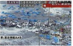
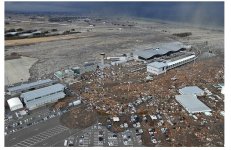
attachment.php
around sendai air port
attachment.php
natori city, miyagi
attachment.php
hakodate station, hokkaido
attachment.php
around sendai air port
attachment.php
hachinohe, aomori
 

Attachments

  • snap20110311181706.jpg
    snap20110311181706.jpg
    90.4 KB · Views: 0
  • snap20110311181612.jpg
    snap20110311181612.jpg
    74.7 KB · Views: 0
  • snap20110311180705.jpg
    snap20110311180705.jpg
    58.4 KB · Views: 0
  • snap20110311180818.jpg
    snap20110311180818.jpg
    82.8 KB · Views: 0
  • K10046014911_1103111654_1103111655_01.jpg
    K10046014911_1103111654_1103111655_01.jpg
    12.5 KB · Views: 0
Re: Japan - Magnitude 7.2 Sanriku Oki (& 8.9 on March 11) - Tsunami warning

Re: Japan - Magnitude 7.2 Sanriku Oki (& 8.9 on March 11) - Tsunami warning

JUNEAU, Alaska
Much of Alaska is under a tsunami watch following a massive earthquake centered in Japan.

The National Weather Service issued a watch stretching from the Southeast border to Chignik. Chignik to Attu remains under an advisory.

According to NWS:

A Tsunami Advisory means that a tsunami capable of producing strong currents or waves dangerous to persons in or very near the water is expected. Significant, widespread inundation is not expected forareas under an advisory. Currents may be hazardous to swimmers, boats, and coastal structures and may continue for several hours after the initial wave arrival.

A Tsunami Watch means that all coastal residents in the watch area should prepare for possible evacuation. A tsunami watch is issued to areas which will not be immediately impacted by the tsunami. Watch areas will either be upgraded to warning or advisory status, or canceled.

Estimated times for potential initial tsunami arrivals are as follows:


Attu 12:20 am

Adak 1:18 am

Akutan 2:24 am

Dutch Harbor 2:28 am

Kodiak 3:58 am

Seward 4:23 am

Yakutat 4:33 am

Sitka 4:33 am

Valdez 4:43 am

Cordova 4:52 am

Homer 5:16 am

Ketchikan 5:40 am

Juneau 5:43 am

Gambell 6:06 am

http://www.ktuu.com/news/ktuu-tsunami-watch-for-much-of-alaska-20110311,0,2657130.story
______________________________________________________
 
Re: Japan - Magnitude 7.2 Sanriku Oki (& 8.9 on March 11) - Tsunami warning

Re: Japan - Magnitude 7.2 Sanriku Oki (& 8.9 on March 11) - Tsunami warning

Measurements or reports of tsunami activity:


Location Lat. Lon. Time Amplitude ------------------------ ----- ------ ------- -----------
Tosashimizu Japan 32.8N 132.9E 0747UTC 00.9FT/00.27M
Tokai Japan 33.8N 137.6E 0645UTC 00.8FT/00.25M
Ofunato Japan 39.0N 141.8E 0605UTC 10.8FT/03.29M
Hanasaki Japan 43.3N 145.6E 0643UTC 09.3FT/02.82M
Boso Japan 34.8N 140.8E 0609UTC 02.6FT/00.78M

Time - Time of measurement.
Amp. - Tsunami amplitudes are measured relative to normal sea level. It is NOT crest-to-trough wave height. Values are given in both meters (M) and feet (FT).

DEEP OCEAN SENSORS INDICATE A LARGE TSUNAMI HAS BEEN GENERATED.


http://wcatwc.arh.noaa.gov/2011/03/11/lhvpd9/04/messagelhvpd9-04.htm

____________________________________________________________

I can't ge logged into the official tsunami warning sites, but our local news sites have current arrival times - assuming it will be the same in California, et al.
 
Re: Japan - Magnitude 7.2 Sanriku Oki (& 8.9 on March 11) - Tsunami warning

Re: Japan - Magnitude 7.2 Sanriku Oki (& 8.9 on March 11) - Tsunami warning

Tsunami warning includes Hawaii

The Pacific warning center urges swift action to protect lives and property.


Reporting from Oahu, Hawaii and Los Angeles -- A widespread tsunami warning is in effect for much of the Pacific Ocean, including Hawaii, where authorities have warned damage could occur along the coasts of all islands.

Warning sirens sounded across Oahu just before 10 p.m. local time. Waves of up to 2 meters above sea level could hit Hawaii just before 3 a.m, or about 5 a.m. Pacific time, Chip McCreary of the the Pacific Tsunami Warning Center told reporters.

"These are not like surf waves," he said. "These waves effectively wrap around islands so all coasts will be affected."

Pacific Tsunami Warning Center officials warned that "urgent action should be taken to protect lives and property. Tsunami waves effectively wrap around islands. All shores are at risk no matter which direction they face."

The massive tsunami, generated in the wake of an 8.9-magnitude earthquake off the coast of Japan, appears to be threatening many Pacific rim countries including Russia, Taiwan, Australia, New Zealand, Central America, South America and Antarctica.

No warning was in effect for the U.S. West Coast, including California.

Tsunamis are a series of long ocean waves, and each wave crest can last five to 15 minutes or more and inundate coastal areas, the warning center said.

"The trough of a tsunami wave may temporarily expose the seafloor but the area will quickly flood again," the warning center said.

Television images have already shown significant tsunami damage in Japan, inundating farmland, structures, and automobiles along the Japanese coast. As the tsunami hit land there, mud-colored water swept cars, roofs and churning debris across fields and flatlands. News footage shot from from the air captured vehicles fleeing ahead of massive sheets of water that carried burning structures along on the surface. The tsunami overtook homes and roads, showing little sign of ebbing.

http://www.latimes.com/news/nationworld/nation/la-naw-hawaii-warning-20110312,0,5340743.story
 
Re: Japan - Magnitude 7.2 Sanriku Oki (& 8.9 on March 11) - Tsunami warning all Pacific areas

Re: Japan - Magnitude 7.2 Sanriku Oki (& 8.9 on March 11) - Tsunami warning all Pacific areas

Google search page has this: Tsunami Alert for New Zealand, the Philippines, Indonesia, Papua New Guinea, Hawaii, and others. Waves expected over the next few hours, caused by 8.9 earthquake in Japan.

Live streaming, showing up to date pics between discussion
http://www.youtube.com/aljazeeraenglish?feature=ticker
 
Re: Japan - Magnitude 7.2 Sanriku Oki (& 8.9 on March 11) - Tsunami warning all Pacific areas

Re: Japan - Magnitude 7.2 Sanriku Oki (& 8.9 on March 11) - Tsunami warning all Pacific areas

Tsunami arrival estimates for Pacific Islands

Posted at 09:25 on 11 March, 2011 UTC

A widespread tsunami warning is in effect for the Northern Marianas, Guam, Wake Is, Taiwan, Yap, Marshall Islands, Philippines, Midway Is, Taiwan, Palau, Yap, Chuuk, Kosrae, Indonesia, Papua New Guinea, Nauru, Johnston Is, Solomon Islands, Kiribati, Howland-Baker, Hawaii, Tuvalu, Palmyra Is, Vanuatu, Cook Islands, Niue, Australia, Fiji, Wallis Futuna, Samoa, American Samoa, New Caledonia, Tonga, Kermadec Is, French Polynesia, New Zealand, Easter Island (Chile) and Pitcairn Island.

The Pacific Tsunami Warning Centre says sea level readings confirm that a tsunami has been generated which could cause widespread damage.

Authorities should take appropriate action in response to this threat.

A tsunami is a series of waves and the first wave may not be the largest.

Tsunami wave heights cannot be predicted and can vary significantly along a coast due to local effects.

The time from one tsunami to the next can be five minutes to an hour and the threat can continue for many hours as multiple waves arrive.

In its fourth warning issued, the Pacific Tusnami Warning Centre has issued the following tsunami arrival estimates for Pacific Islands:

Northern Marianas: 0901 UTC

Guam: 0917 UTC

Yap: 0952 UTC

Marshall Islands (Enewetak): 1021 UTC

Palau: 1030 UTC

Pohnpei: 1036 UTC

Chuuk: 1041 UTC

Manokwari: 1125 UTC

Jayapura: 1142 UTC

Papua New Guinea (Kavieng): 1132 UTC

Nauru: 1157 UTC

Solomon Islands (Panggoe): 1228 UTC

Kiribati (Tarawa): 1236 UTC

Hawaii: 1307 UTC

Tuvalu: 1338 UTC

Vanuatu (Esperitu Santo): 1416 UTC

Tokelau: 1417 UTC

Wallis-Futuna: 1435 UTC

Samoa: 1453 UTC

American Samoa: 1500 UTC

Cook Islands: 1500 UTC

Niue: 1535 UTC

Australia (Cairns): 1535 UTC

Fiji: 1537 UTC

New Caledonia: 1538 UTC

Tonga: 1605 UTC

Kermadec Is: 1656 UTC

French Polynesia (Papeete): 1714 UTC

New Zealand (North Cape): 1723 UTC

Pitcairn Island: 2008 UTC

Easter Islands: 2303 UTC

http://www.rnzi.com/pages/news.php?op=read&id=59311
 
Re: Japan - Magnitude 7.2 Sanriku Oki (& 8.9 on March 11) - Tsunami warning all Pacific areas

Re: Japan - Magnitude 7.2 Sanriku Oki (& 8.9 on March 11) - Tsunami warning all Pacific areas

Tsunami warning issued for Pacific area


SYDNEY, March 11 (UPI) -- The Pacific Tsunami Warning Center issued a tsunami warning for a wide area in the Pacific following Friday's 8.9 magnitude earthquake off Japan's east coast.

The area covered by the warning included Japan, Russia, Marcus Island, North Marianas, Guam, Wake Island and Taiwan, as well as Yap, the Philippines, the Marshall Islands and Belau.

The warning was also posted for Midway Island, Pohnpei, Chuuk, Kosrae, Indonesia, Papua New Guinea, Nauru, Johnston Island, the Solomon Islands, Kiribati, Howland-Baker and Hawaii, as well as Tuvalu, Palmyra Island, Vanuatu, Tokelau, Jarvis Island, Wallis-Futuna, Samoa, and American


Cook Islands, Niue, Australia, Fiji, New Caledonia, Tonga, Mexico, the Kermadec Islands, French Polynesia, New Zealand and Pitcairn were also affected.

The area covered by the warning also included much of Central America and South America, with Guatemala, El Salvador, Costa Rica, Nicaragua, Panama, Honduras, Chile, Ecuador, Colombia and Peru cautioned about possible tsunami dangers. The warning also covered Antarctica.


Read more: http://www.upi.com/Top_News/World-N...acific-area/UPI-41701299830778/#ixzz1GHetiwnH
 
Re: Japan - Magnitude 7.2 Sanriku Oki (& 8.9 on March 11) - Tsunami warning all Pacific areas

Re: Japan - Magnitude 7.2 Sanriku Oki (& 8.9 on March 11) - Tsunami warning all Pacific areas

Tsunami Warning for Part of Aleutians, Flights Diverted to Anchorage

(snipped)

Meanwhile, international flights to Japan are being diverted to Anchorage. A manager at Ted Stevens International Airport said 2 passenger jets are on the ground, one operated by United, the other by American Airlines. Another flight is expected shortly.

http://www.ktuu.com/news/ktuu-tsunami-watch-for-much-of-alaska-20110311,0,2657130.story
 
Re: Japan - Magnitude 7.2 Sanriku Oki (& 8.9 on March 11) - Tsunami warning all Pacific areas

Re: Japan - Magnitude 7.2 Sanriku Oki (& 8.9 on March 11) - Tsunami warning all Pacific areas

What time is it estimated that the tsunami will arrive on US shores and northern Asian shores. I am acutely aware of the damage done to Sri Lanka which was a long way away from the epicentre off Sumatra. Are mobilisiations in place? Have they assessed the risk areas yet?
 
Back
Top