• FluTrackers.com Inc. does not provide medical advice. Information on this web site is collected from various internet resources, and the FluTrackers board of directors makes no warranty to the safety, efficacy, correctness or completeness of the information posted on this site by any author or poster. The information collated here is for instructional and/or discussion purposes only and is NOT intended to diagnose or treat any disease, illness, or other medical condition. Every individual reader or poster should seek advice from their personal physician/healthcare practitioner before considering or using any interventions that are discussed on this website. By continuing to access this website you agree to consult your personal physican before using any interventions posted on this website, and you agree to hold harmless FluTrackers.com Inc., the board of directors, the members, and all authors and posters for any effects from use of any medication, supplement, vitamin or other substance, device, intervention, etc. mentioned in posts on this website, or other internet venues referenced in posts on this website.
  • We are not asking for any donations. Do not donate to any entity who says they are raising funds for us.

Icelandic volcano spews ash cloud - European flights hampered

Re: Icelandic volcano spews ash cloud - European flights to resume

Re: Icelandic volcano spews ash cloud - European flights to resume

<TABLE cellSpacing=0 cellPadding=0 width="100%" border=0><TBODY><TR><TD class=categoryname vAlign=center align=left width="100%" background=../images/bg_topbar.gif height=17>Eruption at the Eyjafjallaj?kull volcanic system</TD><TD width=10></TD></TR><TR><TD colSpan=3 height=10>
pix.gif
</TD></TR></TBODY></TABLE><!-- text area--><TABLE cellSpacing=0 cellPadding=0 width="100%" border=0><TBODY><TR><TD width=10></TD><TD width="90%"><TABLE cellSpacing=0 cellPadding=2 width="100%" border=0><TBODY><TR><TD class=Date>28.4.2010</TD></TR><TR><TD>
News Release 28. April 2010 15:15

</TD></TR><TR><TD>
The water flow from under the G?gj?kull glacier increased shortly before noon today but quickly subsided again. The water level at the Mark?rflj?t bridge has risen slightly.<?xml:namespace prefix = o ns = "urn:schemas-microsoft-com:office:office" /><o:p></o:p>


The clean-up continues in the Eyjafj?ll area. Today the Chief Epidemiologist issued a request to those cleaning up dry ash to use dust masks when working. Dust masks may be obtained at the health care center near the volcano or at the Service Centre at Heimaland.<o:p></o:p>

The airspace around the Reykjav?k and Keflav?k airports has been closed to instrument flights today, causing considerable disruption to flight plans. The airports in Akureyri and Egilssta?ir are open to all air traffic. Flight conditions in Reykjav?k will be checked later today. Flight passengers are advised to seek information about flights from flight operators and at www.textavarp.is .<o:p></o:p>

A media information meeting will be held in Sk?garhl?? tomorrow morning at 8:00 to 9:00. Meteorologist Gu?r?n N?na Petersen and glaciologist Matthew Roberts will attend on behalf of the Meteorological Office, and will answer questions from the media along with Kristj?n Geirsson of the Environment Agency and ?rni Birgisson of ISAVIA.<o:p></o:p>
<o:p></o:p>

National Commissioner of the Icelandic Police <o:p></o:p>
Department of Civil Protection and Emergency Management
<o:p></o:p>


</TD></TR></TBODY></TABLE>http://www.almannavarnir.is/displayer.asp?cat_id=413&module_id=220&element_id=2392</TD></TR></TBODY></TABLE>
 
Re: Icelandic volcano spews ash cloud - European flights to resume

Re: Icelandic volcano spews ash cloud - European flights to resume

Update on activity

Eruption in Eyjafjallaj?kull, Iceland

Current events

Assessment - 03 May 2010 08:35

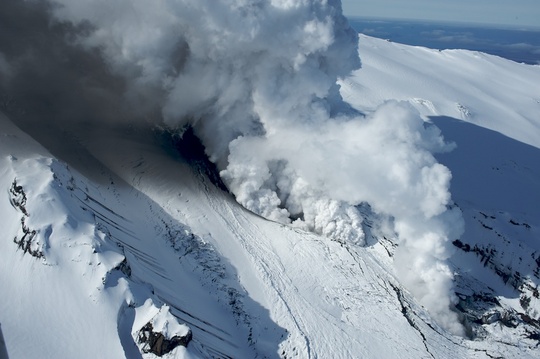
The eruption is mixed, with the lava-producing phase being larger than the explosive phase. During the last 2-3 days, the plume has been darker and wider than in the preceding week. Tephra fall-out in the vicinity of Eyjafjallaj?kull has increased. Dark grey ash clouds are observed over the eruptive site. White steam plumes are rising from G?gj?kull, north of the eruption site. The elevation is 4-5.4 km (13-18,000 ft). Clouds of ash at lower elevations were observed drifting south-east of the eruption site. Moderate ash-fall was reported in the village of V?k at noon, Sunday, located 40 km south-east of Eyjafjallaj?kull.

From the location of the steam plume over G?gj?kull, lava has advanced over 3 km north of the eruption. Steam plumes over the glacier edge from 19:40 GMT suggest that lava may have advanced even further. A rough order-of-magnitude estimate of lava volume can be obtained from the dimensions of the ice canyon. This estimate gives a lava production rate of-the-order 20 m<SUP>3</SUP> s<SUP>-1</SUP> (i.e. 50 tonnes s<SUP>-1</SUP>). The explosive phase may be 10-20 tonnes s<SUP>-1</SUP>.

The explosive phase has increased somewhat in intensity during the last few days. Presently, there are no measurable indications that the eruption is about to end.

No measurable geophysical changes within the Katla volcano.

See more in Status Report issued by Icelandic Meteorological Office and Institute of Earth Sciences, University of Iceland, at 21:00 yesterday evening.
Steam from hidden source
OlSiDSC_6586-en.jpg

Sunday 2nd May 10:00: Steam from melting snow. The lava beneath. Photo: ?lafur Sigurj?nsson.

http://en.vedur.is/earthquakes-and-volcanism/articles/nr/1884
 
Re: Icelandic volcano spews ash cloud - European flights to resume

Re: Icelandic volcano spews ash cloud - European flights to resume

<CITE class=vcard>Ireland shuts airports Tuesday as ash risk returns</CITE>
<CITE class=vcard></CITE>
<CITE class=vcard>By SHAWN POGATCHNIK, Associated Press Writer Shawn Pogatchnik, Associated Press Writer </CITE>? <ABBR class=recenttimedate title=2010-05-03T14:52:53-0700>12 mins ago</ABBR>
<!-- end .byline -->
DUBLIN ? All flights in and out of Ireland have been canceled Tuesday morning because of the renewed risk of volcanic ash drifting south from Iceland, the Irish Aviation Authority announced Monday.

But experts said they couldn't tell whether the shifting winds would lead to wider European airspace shutdowns, mirroring last month's crisis, when more than 100,000 flights were canceled and airlines estimated they lost more than $2 billion in business.

"We cannot really tell what it is going to do," said University of Iceland geophysicist Pall Einarsson.

Ireland's airspace managers said all flights from 7 a.m. to 1 p.m. (0600GMT to 1200GMT) had to be canceled because of "the safety risks to crews and passengers as a result of the drift south of the volcanic ash cloud caused by the northeasterly winds."

The airport shutdown affects both the Republic of Ireland and the British territory of Northern Ireland, leaving the island dependent temporarily on ferry links to Britain and France.

Britain's Civil Aviation Authority also announced a shutdown of air services over Scotland's outermost Hebrides islands Monday night because of the risk that ash could be ingested into aircrafts' jet engines. The shutdowns were the first in Britain and Ireland since April 22, a week after the Eyjafjallajokull (pronounced ay-yah-FYAH-lah-yer-kuhl) volcano erupted in Iceland.
/.../
http://news.yahoo.com/s/ap/20100503/ap_on_bi_ge/eu_iceland_volcano
 
Re: Icelandic volcano spews ash cloud - European flights to resume

Re: Icelandic volcano spews ash cloud - European flights to resume

Update on activity

Eruption in Eyjafjallaj?kull, Iceland

Current events

Assessment - 03 May 2010 19:20

Largest eruption plumes were observed at 5-5,5 km height (17-18,000 ft) estimated from the Icelandic Coast Guard (ICG) flight at 14:30. The plume rises higher after large explosions. It is heading east-south-east to south-east from the eruption site.

Scientists working at G?gj?kull regularly hear explosions and booming sounds and feel the ground vibrate. The vibrations are not felt in 3-4 km distance.

Today water temperature at the Markarfljot bridge was measured 11?C but about 3?C in a 2 km distance from G?gj?kull. Water is flowing on both sides of the glacier and pulses of meltwater flow down the channels every 10 minutes or so. Water level gauge at G?gj?kull also records the pulses.

Temperature measurements at Markarfljot bridge show a pulse of water temperature up to 17?C at 06:00 GMT this morning. Water temperature has now dropped down below 4?C.

No measurable geophysical changes within the Katla volcano.

The overall activity has not changed much since yeasterday (from the last report). Presently there are no indications that the eruption is about to end.

See more in Status Report issued by Icelandic Meteorological Office and Institute of Earth Sciences, University of Iceland, at 16:00..
http://en.vedur.is/earthquakes-and-volcanism/articles/nr/1884
 
Re: Icelandic volcano spews ash cloud - European flights to resume

Re: Icelandic volcano spews ash cloud - European flights to resume

http://icelandreview.com/icelandreview/daily_news/?cat_id=16539&ew_0_a_id=361709

excerpt (May 03):
"Close to midnight last night the lava flow from the volcano appeared to have reached the end of Gígjökull. Eyewitnesses told police in Hvolsvöllur that the lava is flowing by the edge of the glacial tongue. A red glow was seen at Gígjökull."

Hvolsvöllur wider area touristic legend chart (H. rectangled red):

http://icelandreview.com/icelandreview/upload/files/maps/hvolsvollur.jpg
 
Re: Icelandic volcano spews ash cloud - European flights to resume

Re: Icelandic volcano spews ash cloud - European flights to resume

What happened with the webcams?

http://eldgos.mila.is/eyjafjallajokull-fra-valahnjuk/ says "disconnected"
http://eldgos.mila.is/eyjafjallajokull-fra-thorolfsfelli/ view has been changed
http://eldgos.mila.is/eyjafjallajokull-fra-fimmvorduhalsi/ seems to be unchanged; except the wind blows all the ash toward the camera and frequently blocks out the view.

Here is Katla's webcam http://www.ruv.is/katla/
Hekla: http://www.ruv.is/hekla/
 
Re: Icelandic volcano spews ash cloud - European flights to resume

Re: Icelandic volcano spews ash cloud - European flights to resume

<CITE class=vcard>'Summer of uncertainty' looms for Europe aviation

</CITE>
<CITE class=vcard></CITE>
<CITE class=vcard>By SHAWN POGATCHNIK, Associated Press Writer Shawn Pogatchnik, Associated Press Writer </CITE>? <ABBR class=recenttimedate title=2010-05-04T06:56:37-0700>2 hrs 54 mins ago</ABBR>
<!-- end .byline -->
DUBLIN ? Iceland's volcanic ash threatened European air space once again Tuesday, forcing Ireland and some North Atlantic islands to temporarily shut down airports for the first time in 12 days.

Eamonn Brennan, chief of the Irish Aviation Authority, warned of "a summer of uncertainty" in the air due to the continuing eruption of Iceland's Eyjafjallajokul (ay-yah-FYAH-lah-yer-kuhl) volcano.

In Brussels, European Union transport ministers held another emergency aviation meeting and emerged vowing that reforming the continent's patchwork air traffic control system into a one seamless airspace was a "top priority." Germany and France also demanded binding rules to determine when airspaces should be closed and planes grounded because of volcanic ash.

Airlines and airports complained bitterly that EU uncertainty during last month's volcanic crisis grounded too many flights for too long last month. In all, more than 100,000 flights were canceled, inconveniencing 10 million travelers.

Aviation authorities shut down airports throughout Ireland, Scotland's Outer Hebrides islands and the Faeroe Islands for several hours Tuesday after unexpectedly strong and unseasonal winds drove a thick cloud of ash southward from Iceland.

Irish air space reopened at 1 p.m. (1200 GMT, 8 a.m. EDT) and services were scheduled to return to normal as the ash drifted south into the open Atlantic at too low an altitude to pose a risk to aircraft.

Britain's National Air Traffic Service said there was no immediate threat of disruption to British airports but said the situation remained "dynamic." Ireland said there might be new shutdowns Wednesday.

Hanging over all official statements were fears that the volcano in southeast Iceland could keep scattering ash ? and travel chaos ? across Europe all summer.

"We remain at risk (of further shutdowns), particularly towards Wednesday," Brennan said in a telephone interview. "We're probably facing a summer of uncertainty because of this ash cloud."

/.../
http://news.yahoo.com/s/ap/20100504/ap_on_bi_ge/eu_iceland_volcano
 
Re: Icelandic volcano spews ash cloud - European flights to resume

Re: Icelandic volcano spews ash cloud - European flights to resume

Update on activity

Eruption in Eyjafjallaj?kull, Iceland

Current events

Assessment 04 May 2010 19:00

Plume was observed at 5.8-6 km height (19-20,000 ft) estimated from the Icelandic Coast Guard (ICG) flight at 10:40 and 15:30 GMT. It is heading east-south-east to south-east from the eruption site. Plume track clearly visible up to 300-400 km distance from the eruption site on a NOAA satellite image at 13:13 GMT.

Water levels have been rather constant. Water temperature at Markarfljot bridge was low this morning (below 2?C) but seems to be rising (about 5?C at noon). Water level seems to be slightly decreasing.

Lava is still flowing northwards, forming a lava fall down the steep hill under G?gj?kull, about 4 km north of the crater. Blue gas is seen rising from the lava and white steam plumes are seen somewhat lower and mark the front of the lava stream. The size of the eruptive crater is 280 x 190 m.

Lava splashes are thrown at least a few hundred meters into the air.
Overall assessment is that it is more explosive activity and ash production than was observed yesterday. Progression of the lava seems to be slower than yesterday.

Presently there are no indications that the eruption is about to end. No measurable geophysical changes within the Katla volcano.

See more in Status Report issued by Icelandic Meteorological Office and Institute of Earth Sciences, University of Iceland, at 15:00.

http://en.vedur.is/earthquakes-and-volcanism/articles/nr/1884
 
Re: Icelandic volcano spews ash cloud - European flights hampered

More Flights Are Grounded As Iceland's Volcanic Cloud Reappears

May 5, 2010 Jennifer Young

Parts of UK airspace are closed again as a result of Iceland's volcanic plume. Who is responsible for taking the decision, and on what basis?

The volcanic cloud which caused six days of travel disruption across Europe in April has returned, closing airports and suspending flights in many airports in the north and west of the UK (5 May 2010). During the initial period of closure, many questions raised as to whether or not the authorities had over-reacted in closing airspace. This time, they are taking more care to explain and justify their decisions.


Read more at Suite101: More Flights Are Grounded As Iceland's Volcanic Cloud Reappears http://news.suite101.com/article.cf...olcanic-cloud-reappears-a233688#ixzz0n3SaVmtV
 
Re: Icelandic volcano spews ash cloud - European flights hampered

Update on activity

Eruption in Eyjafjallaj?kull, Iceland

Current events

Magma intrusion - 05 May 2010 13:40

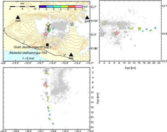
Since Monday 3 May, increased earthquake activity beneath Eyjafjallaj?kull has been recorded. Precise locations of the earthquakes show that their source is at first very deep, at about 23 km depth, but then migrates upwards. This strongly indicates that ?new? magma is intruding into the magma conduit and pushing on the over-lying magma, causing a difference in pressure at the surface. It is therefore anticipated that the eruption will continue at full force in the next days.

Significant changes in horizontal movement at GPS stations around Eyjafjallaj?kull have been observed in the last 48 hours. Renewed northward displacement is seen at stations BAS2 and STE2, located just north of the ice cap. To the south, westward movement is apparent at THEY (see figure below), while station FIM2 - located further east - shows eastward movement.

The distribution of earthquake activity in the magma conduit could also indicate the location of the magma chamber that has fuelled the eruption since 14 April. It is considered to be at a depth of approx. 3-5 kilometers, in an area where no earthquakes are detected.
T3-2010-1-5may-100505.png

Larger figure
Figure text: Earthquake activity beneath Eyjafjallaj?kull in April and May 2010. The green and bluegreen circles represent earthquakes occurring on 3-4 May, first at a great depth and gradually moving upwards on 4 May. The white circles represent earthquakes that were recorded from 13 to 30 April. Gray, open circles show earthquake locations from 2009 to March 2010. The red star represents the source of an M2.7 earthquake that was recorded at the beginning of an intense earthquake swarm that preceded the onset of the eruption by a couple of hours. The black stars show the location of the eruptive fissures at the summit and flank (Fimmv?r?uh?ls) of Eyjafjallaj?kull.

GPS stations BAS2, FIM2, and STE2 are operated in collaboration with the Earth Sciences Institute, University of Iceland. For further details, see site at IMO and site at Earth Sciences Institute.

http://en.vedur.is/earthquakes-and-volcanism/articles/nr/1884
 
Re: Icelandic volcano spews ash cloud - European flights hampered

I just now discovered there have been interactive maps added to the webcam sites.

Click on the map to enlarge it and a small one also appears. Click on the small square in the small map and move the square to view other areas of Iceland. Pretty neat.

Thank you Iceland for giving us the opportunity to watch this all in real time :tiphat:
 
Re: Icelandic volcano spews ash cloud - European flights hampered

Link to show tremors for the Eyjafjallaj?kull eruption ... http://hraun.vedur.is/ja/Katla2009/gosplott.html

Note the link contains the word Katla but the page does not contain Katla information

This message is on their site
Katla is NOT erupting and there are NO indications that Katla is about to erupt. Information on this page is for the Eyjafjallaj?kull eruption.
 
Re: Icelandic volcano spews ash cloud - European flights hampered

<TABLE cellSpacing=0 cellPadding=0 width="100%" border=0><TBODY><TR><TD colSpan=3 height=21>Iceland</TD></TR><TR><TD width=10></TD><TD class=categoryname vAlign=center align=left width="100%" background=../images/bg_topbar.gif height=17>Eruption at the Eyjafjallaj?kull volcanic system</TD><TD width=10></TD></TR><TR><TD colSpan=3 height=10>
pix.gif
</TD></TR></TBODY></TABLE><!-- text area--><TABLE cellSpacing=0 cellPadding=0 width="100%" border=0><TBODY><TR><TD width=10></TD><TD width="90%"><TABLE cellSpacing=0 cellPadding=2 width="100%" border=0><TBODY><TR><TD class=Date>5.5.2010</TD></TR><TR><TD>
News Release, May 5, 2010

</TD></TR><TR><TD>

Recently there has been an increase in attempts to enter the closed areas around the eruption site in Eyjafjallaj?kull. Even though the eruption is an awe-inspiring event that is fascinating to observe, there are dangers involved. The closures shown on the map published on 27 April 2010 are still fully in effect.

It is not fully known what effects the upheaval has had on the glacier itself. Fissures may have formed, and at least one melt water channel about 50 m deep has formed on the glacier''''s south side.

The glacial barrier between the crater on the top of Eyjafjallaj?kull and G?gj?kull is close to cracking.

When that happens poisonous gases, such as carbon dioxide (CO2) and hydrogen sulfide (H2S), will flow more easily down G?gj?kull and into the area in front of the glacier.

Volcanic eruptions of this type may unleash pyroclastic surges down channels such as the one formed by G?gj?kull, although this is uncommon. A pyroclastic surge is formed when a mixture of gas and fine particles form low volcanic plumes above erupting craters or when ash falls from a dense eruption column. Pyroclastic surges travel fast downhill, so their potential channels should be avoided.

The Civil Protection Department has received notifications of a rumbling noise from several locations in Iceland. Yesterday, the rumbling could be heard in western Iceland, and this morning similar rumbling could be heard in the south-western peninsulas and in the M?rar district. According to information from the Icelandic Met Office, this rumbling is most likely from the Eyjafjallaj?kull volcano and the noise carries far because of weather conditions and atmospheric moisture. The matter is being investigated further.

The service centre in Heimaland is open every day from 11:00?15:00. Experts have visited the centre and presented the local residents with the latest information. Meetings will be held all this week at Heimaland from 12:00 ? 13:30.

In the meeting yesterday, J?hann Hermannsson, agronomist, answered questions and today, Halld?r Run?lfsson, Chief Veterinary Officer, will give a lecture and answer questions. On Wednesday, May 5, Sveinn Run?lfsson, Director of the Soil Conservation Service, will be available to answer questions, followed on Thursday, May 6 by Sigurgeir ?orgeirsson, Permanent Secretary of the Ministry of Fisheries and Agriculture, and on May 7 by Haraldur Benediktsson, Director of the Farmers'''' Association of Iceland.

Residents are encouraged to visit Heimaland and get information on matters relating to the volcanic eruption and its effects.

A representative of the municipal authority will be at Heimaland every day from 12:00 - 13:30
Vagn Kristj?nsson is the Project Manager for the Department of Civil Protection and Emergency Management. He can be reached by phone at: 847 4230. Email: heimaland@visir.is

http://www.almannavarnir.is/displayer.asp?cat_id=413&module_id=220&element_id=2406


</TD></TR></TBODY></TABLE></TD></TR></TBODY></TABLE>
Map of restricted area around Eyjafjallajokull

http://www.almannavarnir.is/upload/files/Eyjafjallajokull_bannsvaedi_27042010.pdf
 
Re: Icelandic volcano spews ash cloud - European flights hampered

Eruption in Eyjafjallaj?kull - Status Report: 18:00 GMT, 06 May 2010
Icelandic Meteorological Office and Institute of Earth Sciences, University of Iceland

Compiled by: Sigurlaug Hjaltad?ttir, Bj?rn Oddsson, Egill Axelsson, Matthew J. Roberts, Sigr?n Hreinsd?ttir, Halld?r Bj?rnsson, Berg??ra S. ?orbjarnard?ttir.

Based on:
IMO seismic monitoring; IES-IMO GPS monitoring; IMO hydrological data; IMO weather radar measurements, MODIS satellite image; reports from sent through the IMO web site, information from the Icelandic Coast Guard flight yesterday.

Eruption plume:
Height (a.s.l.): The ash plume observed from commercial pilots between 0530h and 0800h: 30,000 ft/9km. ICG helicopter flight between 13h and 14h: sometimes under 20,000 ft (where there is a cloud bank) and oscillates up into the cloud bank (over 9 km). The height of the plume varies from 4-6 km according to the weather radar. Icelandair Cargo flight at
18:00 climbing towards east from Keflav?k estimates height at 21- 22,000ft.
Heading: East-south-east over land, then to the south (assessed from AVHRR figure from NOAA at 0435h and 1154h).

Colour: A police officer from Hvolsv?llur, stationed at Rau?afell, observed the ash plume to be dark-gray. Observation from ICG: dark.

Tephra fallout: Considerable ashfall at ?ykkvab?jarklaustur in ?lftaver (at a distance of 65-70 km), (everything has turned black). It has not been established whether the ash cloud south of Eyjafjallaj?kull is ashfall or ash that has already fallen and is being blown from the ground. Ashfall seems to start midway through M?rdalssandur.

Lightning: No detections today over the eruption site.

Noises: No noise can be heard at Hvolsv?llur. No noise was heard at Seljavellir at noon. Noise heard at Heggsta?anes (200 to the north).

Meltwater:
Discharge from G?gj?kull decreases further and meltwater seems to be running from the eastern side of the glacier. This is different from tuesdays meltwater were water was running from the west side. Lava flow might be changing the direction of meltwater flow. Such changes should be taken seriously with regard to possible outbursts due to accumulation of meltwater. Discharge at the old Markarflj?ts bridge is decreasing. It has now been verified that increase in electrical conducitvity in J?kuls? ? S?lheimasandi was caused by volcanic ash penetrating the glacier and the meltwater. This rules out the possibility of sulphur rich gas from magma entering the meltwater.

Conditions at eruption site:
The lava stream down G?gj?kull has been stationary for the
last two days. Explosive activity has increased and the cinder cone
continues to build up in the northern most ice cauldron.

Seismic tremor:
Tremor levels continued to decrease yesterday and this morning. They are now similar to what they were in the first phase of the eruption, 14 to 17 April.

Earthquakes:
Earthquake activity is still being recorded. At least 10 earthquakes have been located since midnight. Most of the earthquakes are sourced beneath or south of the top crater in the eruptive conduit that has formed since 3 May. Most of the earthquakes are less than magnitude 2, the biggest M2.2. Three events have been recorded beneath the southeastern ice cap, depth uncertain.

GPS deformation:
Measurements from around Eyjafjallaj?kull show continued horizontal displacement. South of the eruption, stations THEY and SVBH have begun to drift southward, whereas FIM2, located east of the eruption, shows northward motion. No further northward motion has been observed at STE2, located to the north. Today's displacement pattern suggests deformation beneath the southeastern part of Eyjafjallaj?kull.

Other remarks:
Between 14 April and 5 May no signals (exept diurnal and long-period earth tides) are seen at strain-station St?r?lfshvoll, ~35 km WNW of the eruption.

Overall assessment:
Explosive activity has increased and effusive part has decreased for the last two days. This results in a higher eruption column with increased tephra fallout. There are no signs that the eruption is about to end.

http://www.earthice.hi.is/page/ies_Eyjafjallajokull_eruption
 
Re: Icelandic volcano spews ash cloud - European flights hampered

<TABLE cellSpacing=0 cellPadding=0 width="100%" border=0><TBODY><TR><TD colSpan=3 height=21></TD></TR><TR><TD width=10></TD><TD class=categoryname vAlign=center align=left width="100%" background=../images/bg_topbar.gif height=17>Eruption at the Eyjafjallaj?kull volcanic system</TD><TD width=10></TD></TR><TR><TD colSpan=3 height=10>
pix.gif
</TD></TR></TBODY></TABLE><!-- text area--><TABLE cellSpacing=0 cellPadding=0 width="100%" border=0><TBODY><TR><TD width=10></TD><TD width="90%"><TABLE cellSpacing=0 cellPadding=2 width="100%" border=0><TBODY><TR><TD class=Date>7.5.2010</TD></TR><TR><TD>
Extensive ash fall from Eyjafjallaj?kull last night and this morning
</TD></TR><TR><TD>
There has been extensive ash fall in the Eyjafj?ll area, in V?k ? M?rdal and ?lftaver. The Environment Agency''s measurements in V?k ? M?rdal show air borne particle levels exceeding the health regulation levels, with a 24 hour average for yesterday of 418 ?g/m3. Last night yielded the highest hourly levels from the beginning of air borne particle measurements in Iceland. People are urged to stay indoors under these conditions and to not leave the house without a dust mask and protective glasses.

It is also necessary to seal doors and windows.

Raising the temperature indoors can keep ask from getting in. According to information from the Meteorological Office, ash fall can be expected to the south and south-east of Eyjafjallaj?kull today and until around noon tomorrow. More information can be found in the brochures on ash fall and the health effects of volcanic ash.

http://www.almannavarnir.is/displayer.asp?cat_id=413&module_id=220&element_id=2410

</TD></TR></TBODY></TABLE></TD></TR></TBODY></TABLE>
 
Re: Icelandic volcano spews ash cloud - European flights hampered

<TABLE cellSpacing=0 cellPadding=0 width="100%" border=0><TBODY><TR><TD class=categoryname vAlign=center align=left width="100%" background=../images/bg_topbar.gif height=17>Eruption at the Eyjafjallaj?kull volcanic system</TD><TD width=10> </TD></TR><TR><TD colSpan=3 height=10>
pix.gif
</TD></TR></TBODY></TABLE><!-- text area--><TABLE cellSpacing=0 cellPadding=0 width="100%" border=0><TBODY><TR><TD width=10></TD><TD width="90%"><TABLE cellSpacing=0 cellPadding=2 width="100%" border=0><TBODY><TR><TD class=Date>7.5.2010</TD></TR><TR><TD>
News Release May 7, 2010</TD></TR><TR><TD>Information on the health effects of volcanic ash from the Chief Epidemiologist, the Environment Agency, the South Iceland Health Surveillance and the Department of Civil Protection and Emergency Management

Due to extensive ash fall in V?k ? M?rdal and the surrounding areas, with air borne particle measurements reaching levels far above health regulation levels, the Red Cross has temporarily opened mass emergency reception centres in V?k ? M?rdal and Kirkjub?jarklaustur. Those intending to leave the ash fall areas are requested to register at a Red Cross emergency reception centre. In V?k the emergency reception centre is situated in the community hall Leiksk?lar, at V?kurbraut 8, and in Kirkjub?jarklaustur it is situated in the elementary school.

Practical advice:

? Those who can are advised not to stay in areas where ash fall is clearly visible and those who must stay in the ash fall areas are requested to stay indoors as much as possible.
? Decrease the ash getting into houses by sealing windows with adhesive tape. It is important to immediately clean up any ash that gets inside the house.
? Take care to disturb fallen ash as little as possible.
? Outdoors it is important to use dust masks and eye protection glasses. Masks must be kept in stock and changed frequently. Masks can be obtained from the health care centers in the ash fall areas, at the emergency reception centres and at the information center in Heimaland.
? Driving swirls up the ash and therefore it is important not to drive unless absolutely necessary and to drive slowly.
</TD></TR></TBODY></TABLE></TD></TR></TBODY></TABLE>
http://www.almannavarnir.is/displayer.asp?cat_id=413&module_id=220&element_id=2413
 
Re: Icelandic volcano spews ash cloud - European flights hampered

Update on activity

Eruption in Eyjafjallaj?kull, Iceland

Current events

EUMETSAT animation - 07 May 2010 15:15

During the evening of 5 May there was an abrupt increase in ash discharge from Eyjafjallaj?kull.

Aerosol particles are detectable through their light scattering properties. Their signature is a particular brightness temperature (channel) diffence recorded by meteorological satellites and other earth observation satellites. This type of detection is one of the main observational evidence for the existense of ash particles in the atmosphere.

The method, when utilizing 11 micrometer and 12 micometer wavelength channels, works well for ash clouds with mean aerosol sizes of less than 6 microns. The detection is however largely limited by cloudy conditions, which can hinder the progression of the warm thermal background radiation through the aerosol and up to the thermal imaging camera of the satellite. For strong detection it is important that the background be warm in comparison to the aerosol. A thermal background such as from the ocean surface, land or low clouds, works best because warm objects radiate more and result in greater amounts of scattered radiation, light-particle 'collisions' if you will.

As a cooperating member of EUMETSAT, the Icelandic Meteorological Office can monitor these ash signatures in real time. The animation shows the development of the volcanic ash cloud from the evening of
Wednesday 5th May till afternoon Thursday 6th May. The ash is clearly detectable by Brightness Temperature Difference (BTD) between two thermal channels in meteorological satellites. The images were generated chiefely with channels from EUMETSATS?s geostationary satellite, MSG.

However, image segments from NOAA's polar orbiting satellites are superimposed ontop where they were available.

The images show that most of the thermal background radiation comes from low clouds at ca. -20?C, while the aerosol temperature up at high altitudes would have been much lower, near -60?C.

An earlier article can be viewed relating to the spread of the initial ash cloud on 15th April. Aerosol from soil and sand is detectable with the same techniques. An article was written relating to the detection of sand aerosol from Landeyjasandur in Iceland, earlier this year.

The following animation is based on EUMETSAT-MSG and NOAA-AVHRR satellite images from Wedenesday through Thursday, showing ash dispersion from Eyjafjallaj?kull.

http://en.vedur.is/earthquakes-and-volcanism/articles/nr/1884
 
Back
Top