 Tweet
Tweet
Re: NOAA Observations Indicate a Small Portion of Light Oil Sheen Has Entered the Loop Current
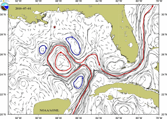
Current Ocean Conditions in the Gulf of Mexico
Why are these maps helpful?
These maps of ocean surface currents determined from satellite measurements provide information to scientists, decision makers, and emergency response personnel about the present oceanic flows and how they are changing with time.
The map below shows the latest estimate of the surface currents in the Gulf of Mexico. The red star indicates the location of the Deepwater Horizon. The solid contours indicate the location of the Loop Current and anticyclonic rings and eddies (red) and cyclonic eddies (blue).
...
Animation of the surface currents field:
JULY 2010
<CENTER></CENTER>
 <SCRIPT language=JavaScript> <!-- resizeToImage(700,501); // --> </SCRIPT>
Animation of the surface currents field:
AUGUST 2010
 <SCRIPT language=JavaScript> <!-- resizeToImage(700,501); // --> </SCRIPT>
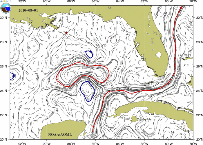
Current Ocean Conditions in the Gulf of Mexico
Why are these maps helpful?
These maps of ocean surface currents determined from satellite measurements provide information to scientists, decision makers, and emergency response personnel about the present oceanic flows and how they are changing with time.
The map below shows the latest estimate of the surface currents in the Gulf of Mexico. The red star indicates the location of the Deepwater Horizon. The solid contours indicate the location of the Loop Current and anticyclonic rings and eddies (red) and cyclonic eddies (blue).
...
Animation of the surface currents field:
JULY 2010
<CENTER></CENTER>
<SCRIPT language=JavaScript> <!-- resizeToImage(700,501); // --> </SCRIPT>Animation of the surface currents field:
AUGUST 2010
<SCRIPT language=JavaScript> <!-- resizeToImage(700,501); // --> </SCRIPT>
Comment