• FluTrackers.com Inc. does not provide medical advice. Information on this web site is collected from various internet resources, and the FluTrackers board of directors makes no warranty to the safety, efficacy, correctness or completeness of the information posted on this site by any author or poster. The information collated here is for instructional and/or discussion purposes only and is NOT intended to diagnose or treat any disease, illness, or other medical condition. Every individual reader or poster should seek advice from their personal physician/healthcare practitioner before considering or using any interventions that are discussed on this website. By continuing to access this website you agree to consult your personal physican before using any interventions posted on this website, and you agree to hold harmless FluTrackers.com Inc., the board of directors, the members, and all authors and posters for any effects from use of any medication, supplement, vitamin or other substance, device, intervention, etc. mentioned in posts on this website, or other internet venues referenced in posts on this website.
  • We are not asking for any donations. Do not donate to any entity who says they are raising funds for us.

Tropical storm Don laps at Texas coast, little rain

Pathfinder

Editor, Senior Moderator
Atlantic Graphical TWO Area 1 closeup


<HR align=left width="100%" noShade><!-- Content here --> Return to Atlantic Graphical TWO


1. THUNDERSTORM ACTIVITY ASSOCIATED WITH A TROPICAL WAVE NEAR THE YUCATAN CHANNEL CONTINUES TO BECOME BETTER ORGANIZED...AND RADARDATA FROM MEXICO SUGGESTS THAT A CIRCULATION COULD BE FORMING ABOUT50 MILES NORTHEAST OF CANCUN. IF CURRENT TRENDS CONTINUE...ATROPICAL DEPRESSION COULD DEVELOP LATER TODAY. INTERESTS IN THENORTHEASTERN YUCATAN PENINSULA...AS WELL AS THE CENTRAL AND WESTERNGULF OF MEXICO...SHOULD MONITOR THE PROGRESS OF THIS SYSTEM AS ITMOVES WEST-NORTHWESTWARD NEAR 15 MPH. THIS SYSTEM HAS A HIGHCHANCE...80 PERCENT...OF BECOMING A TROPICAL CYCLONE DURING THENEXT 48 HOURS. AN AIR FORCE RESERVE HURRICANE HUNTER AIRCRAFT ISSCHEDULED TO INVESTIGATE THIS SYSTEM LATER TODAY.


</PRE><!-- Set from archive.pl for LANA crossing 140W --><!-- END OF CONTENT -->http://www.nhc.noaa.gov/gtwo/gtwo_atl_sub.shtml?area1#contents
 
Tropical storm Don forms over the southern gulf of Mexico

Tropical storm Don forms over the southern gulf of Mexico

BULLETIN
TROPICAL STORM DON ADVISORY NUMBER 1
NWS NATIONAL HURRICANE CENTER MIAMI FL AL042011
400 PM CDT WED JUL 27 2011

...TROPICAL STORM DON FORMS OVER THE SOUTHERN GULF OF MEXICO...


SUMMARY OF 400 PM CDT...2100 UTC...INFORMATION
----------------------------------------------
LOCATION...22.2N 87.0W
ABOUT 120 MI...190 KM N OF COZUMEL MEXICO
ABOUT 755 MI...1220 KM ESE OF CORPUS CHRISTI TEXAS
MAXIMUM SUSTAINED WINDS...40 MPH...65 KM/H
PRESENT MOVEMENT...WNW OR 295 DEGREES AT 12 MPH...19 KM/H
MINIMUM CENTRAL PRESSURE...1001 MB...29.56 INCHES


WATCHES AND WARNINGS
--------------------
THERE ARE NO COASTAL WATCHES OR WARNINGS IN EFFECT. INTERESTS IN
THE NORTHWESTERN GULF OF MEXICO SHOULD MONITOR THE PROGRESS OF DON.
WATCHES AND/OR WARNINGS MAY BE REQUIRED FOR PORTIONS OF THE TEXAS
COAST TONIGHT OR THURSDAY.


DISCUSSION AND 48-HOUR OUTLOOK
------------------------------
AT 400 PM CDT...2100 UTC...THE CENTER OF TROPICAL STORM DON WAS
LOCATED NEAR LATITUDE 22.2 NORTH...LONGITUDE 87.0 WEST. DON IS
MOVING TOWARD THE WEST-NORTHWEST NEAR 12 MPH...19 KM/H. A GENERAL
NORTHWESTWARD MOTION IS EXPECTED DURING THE NEXT 48 HOURS. ON THE
FORECAST TRACK...THE CENTER OF DON SHOULD MOVE THROUGH THE
SOUTHERN AND CENTRAL GULF OF MEXICO TONIGHT AND THURSDAY...AND
APPROACH THE COAST OF THE NORTHWESTERN GULF OF MEXICO FRIDAY.

REPORTS FROM AN AIR FORCE RESERVE HURRICANE HUNTER AIRCRAFT INDICATE
THAT MAXIMUM SUSTAINED WINDS ARE NEAR 40 MPH...65 KM/H...WITH
HIGHER GUSTS. GRADUAL STRENGTHENING IS FORECAST DURING THE NEXT
48 HOURS.

TROPICAL STORM FORCE WINDS EXTEND OUTWARD UP TO 45 MILES...75 KM
MAINLY TO THE EAST OF THE CENTER.

THE MINIMUM CENTRAL PRESSURE REPORTED BY THE HURRICANE HUNTERS IS
1001 MB...29.56 INCHES.


HAZARDS AFFECTING LAND
----------------------
NONE.


NEXT ADVISORY
-------------
NEXT COMPLETE ADVISORY...1000 PM CDT.

$$
FORECASTER BEVEN

http://www.nhc.noaa.gov/text/refresh/MIATCPAT4+shtml/272053.shtml
 
Re: Tropical storm Don forms over the southern gulf of Mexico

Re: Tropical storm Don forms over the southern gulf of Mexico

Tropical Storm Force Wind Speed Probabilities - 120 Hours
Select a Future Forecast Time Below:
0 12 24 36 48 60 72 84 96 108 120 hours Loop


Click image to zoom in ? Download GIS data: 0.1 degree .shp 0.5 degree .shp


Click Here for a Printer Friendly Graphic

Coastal Watches/Warnings and 5-Day Forecast Cone for Storm Center

Click image to zoom in ? Download GIS data
Other images: 5-Day track on ? 3-Day track on ? 3-Day track off


Click Here for a Printer Friendly Graphic
Note: If a storm is expected to dissipate within 5 days, its track will be shorter

http://www.nhc.noaa.gov/refresh/graphics_at4+shtml/205313.shtml?5-daynl#contents
 
Re: Tropical storm Don forms over the southern Gulf of Mexico

Re: Tropical storm Don forms over the southern Gulf of Mexico

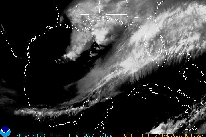
GULFWV.JPG

http://www.goes.noaa.gov/GIFS/GULFWV.JPG
--------------------------------------------------


Tropical Storm Don Forms Off Mexico?s Yucatan on Track for Texas Coast

<CITE class=byline>By Brian K. Sullivan - <SCRIPT type=text/javascript>document.write(dateFormat(new Date(1311812105000),"mmm d, yyyy h:MM TT Z"));</SCRIPT>Jul 27, 2011 7:15 PM CT <NOSCRIPT></NOSCRIPT></CITE>

Excerpt:

Energy companies have begun pulling some workers from their facilities in the Gulf as a precaution. Royal Dutch Shell Plc (RDSA) said it?s evacuating about 70 non-essential workers, while Apache Corp. (APA) and Anadarko Petroleum Corp. (APC), the two largest U.S. independent oil and gas producers by market value, said they are removing non-essential workers from some western Gulf operations.


BP Plc has evacuated non-essential personnel from its Southern Green
Canyon area, which includes the Atlantis, Mad Dog and Holstein platforms, according to a message recorded on the company?s hurricane hotline...
...
The biggest factor in determining where the storm will go is the same high pressure system that?s driving temperatures into the 100s across much of the central and southern U.S., Kottlowski said by telephone. That system may act as a barrier to deflect the storm into Texas or Mexico, depending on its strength and exact location.

Full text:
http://www.bloomberg.com/news/2011-...tic-ocean-on-track-to-southeastern-texas.html
 
Tropical storm Don heading toward the central Gulf of Mexico - Watch issued for Texas coast

Tropical storm Don heading toward the central Gulf of Mexico - Watch issued for Texas coast

Tropical Storm DON Public Advisory

BULLETIN
TROPICAL STORM DON ADVISORY NUMBER 2
NWS NATIONAL HURRICANE CENTER MIAMI FL AL042011
1000 PM CDT WED JUL 27 2011

...TROPICAL STORM DON HEADING TOWARD THE CENTRAL GULF OF MEXICO WITH
LITTLE CHANGE IN STRENGTH...


SUMMARY OF 1000 PM CDT...0300 UTC...INFORMATION
-----------------------------------------------
LOCATION...22.8N 88.1W
ABOUT 675 MI...1085 KM ESE OF CORPUS CHRISTI TEXAS
MAXIMUM SUSTAINED WINDS...40 MPH...65 KM/H
PRESENT MOVEMENT...WNW OR 300 DEGREES AT 12 MPH...19 KM/H
MINIMUM CENTRAL PRESSURE...1000 MB...29.53 INCHES


WATCHES AND WARNINGS
--------------------
CHANGES WITH THIS ADVISORY...

A TROPICAL STORM WATCH HAS BEEN ISSUED FOR THE TEXAS COAST FROM
PORT MANSFIELD NORTHWARD TO WEST OF SAN LUIS PASS.

SUMMARY OF WATCHES AND WARNINGS IN EFFECT...

A TROPICAL STORM WATCH IS IN EFFECT FOR...
* PORT MANSFIELD NORTHWARD TO WEST OF SAN LUIS PASS

A TROPICAL STORM WATCH MEANS THAT TROPICAL STORM CONDITIONS ARE
POSSIBLE WITHIN THE WATCH AREA...GENERALLY WITHIN 48 HOURS.

FOR STORM INFORMATION SPECIFIC TO YOUR AREA IN THE UNITED
STATES...INCLUDING POSSIBLE INLAND WATCHES AND WARNINGS...PLEASE
MONITOR PRODUCTS ISSUED BY YOUR LOCAL NATIONAL WEATHER SERVICE
FORECAST OFFICE. FOR STORM INFORMATION SPECIFIC TO YOUR AREA OUTSIDE
THE UNITED STATES...PLEASE MONITOR PRODUCTS ISSUED BY YOUR NATIONAL
METEOROLOGICAL SERVICE.


DISCUSSION AND 48-HOUR OUTLOOK
------------------------------
AT 1000 PM CDT...0300 UTC...THE CENTER OF TROPICAL STORM DON WAS
LOCATED NEAR LATITUDE 22.8 NORTH...LONGITUDE 88.1 WEST. DON IS
MOVING TOWARD THE WEST-NORTHWEST NEAR 12 MPH...19 KM/H. THIS GENERAL
MOTION IS EXPECTED TO CONTINUE THROUGH FRIDAY. ON THIS TRACK...THE
CENTER OF DON SHOULD MOVE THROUGH THE SOUTHERN AND CENTRAL GULF OF
MEXICO ON THURSDAY...AND APPROACH THE TEXAS COAST ON FRIDAY.

MAXIMUM SUSTAINED WINDS REMAIN NEAR 40 MPH...65 KM/H...WITH HIGHER
GUSTS. SOME STRENGTHENING IS FORECAST DURING THE NEXT 48 HOURS. AN
AIR FORCE RECONNAISSANCE PLANE IS SCHEDULED TO CHECK DON AT
DAYBREAK.

TROPICAL STORM FORCE WINDS EXTEND OUTWARD UP TO 45 MILES...75 KM
FROM THE CENTER.

ESTIMATED MINIMUM CENTRAL PRESSURE IS 1000 MB...29.53 INCHES.


HAZARDS AFFECTING LAND
----------------------
NONE.


NEXT ADVISORY
-------------
NEXT INTERMEDIATE ADVISORY...100 AM CDT.
NEXT COMPLETE ADVISORY...400 AM CDT.

$$
FORECASTER AVILA

http://www.nhc.noaa.gov/text/refresh/MIATCPAT4+shtml/280231.shtml
 
Re: Tropical storm Don heading toward the central Gulf of Mexico - Watch issued for Texas coast

Re: Tropical storm Don heading toward the central Gulf of Mexico - Watch issued for Texas coast

July 28, 2011
Tropical Storm Don churns toward Texas

Posted: 07:40 AM ET

Tropical storm Don is headed towards the coast of TX, and should make a landfall somewhere near Corpus Christi late Fri night or early Sat morning. Right now the winds are around 40 mph, but it doesn?t look very organized on the radar. It will start to churn into warmer water as it heads to the Western Gulf of Mexico that will help it intensify, and the National Hurricane Center brings it up to a 60 mph storm by Fri night (hurricane force winds are 75 mph). This could be some great news for parched TX, b/c it has the potential to bring a good 3-6? of rain with it, possibly a little more. It will also cool the temps down for a day or two as far north as lower OK. We?ll see how strong he gets, and what the weather will be like for the Western Gulf over the next few days...
Posted by: Meteorologist Bob Van Dillen

Full text:
http://mxp.blogs.cnn.com/2011/07/28/tropical-storm-don-churns-toward-texas/

More...
 
Re: Tropical storm Don heading toward the central Gulf of Mexico - Watch issued for Texas coast

Re: Tropical storm Don heading toward the central Gulf of Mexico - Watch issued for Texas coast

<TABLE class=full cellSpacing=0 cellPadding=0><TBODY><TR><TD class=full>Tropical Storm Don unimpressive so far


</TD><TD></TD></TR></TBODY></TABLE></B>By Dr. Jeff Masters

<SCRIPT type=text/javascript> (function($){ $("div#socialWeather > a[id^='social']").each(function(index) { $(this).hover(function () { $(this).parent().css('background-position','0px -' +(26*(index+1))+ 'px'); }, function () { $(this).parent().css('background-position','0px 0px'); }); }); $("#socialTwitter").click(function() { locationurl="http%3A%2F%2Fwww.wunderground.com%2Fblog%2FJeffMasters%2Farticle.html"; var miniurl = $.ajax({ url: "/miniurl/api.php?url="+locationurl, async: false }).responseText; if(miniurl && miniurl.length>0) pageurl="http://twitter.com/share?url=" + encodeURIComponent(miniurl) + "&via=wunderground&related=wunderground&text=Tropical+Storm+Don+unimpressive+so+far"; else pageurl="http://twitter.com/share?url=" + locationurl + "&via=wunderground&related=wunderground&text=Tropical+Storm+Don+unimpressive+so+far"; window.open(pageurl,"twitterwindow","menubar=1,resizable=0,width=550,height=370"); return false; }); })(jQuery); </SCRIPT>Published: 2:08 PM GMT on July 28, 2011


Excerpt:

Forecast for Don
The big question for Don is, will it be a boon or bane for Texas? The state is currently suffering through its worst drought in recorded history, and Don has the potential to bring some decent drought-busting rains to the state. If Don can expand in size and intensify to a 50 - 55 mph tropical storm, it has the capability to bring hundreds of millions of dollars worth of beneficial rains to the state. However, we have a Goldilocks problem. We can't have Don intensifying into a hurricane, or its winds and flooding might bring hundreds of millions in damage. Neither do we want Don to stay in its current state, which is too small and weak to bring significant rains to Texas. If Don follows the current NHC forecast, which brings the storm up to a moderate-strength tropical storm, that would be just right. This forecast is low-confidence, though, since Don's small size makes it prone to sudden changes in strength, either upward or downward. NHC is giving Don just a 14% chance of intensifying into a hurricane in its 5am advisory, but this could easily change upward if Don manages to overcome its vertical tilt and start consolidating an eyewall. I put the odds of Don reaching hurricane strength at 30%. None of the computer models is predicting Don will become a hurricane.

Full text:
http://www.wunderground.com/blog/JeffMasters/article.html
 
Re: Tropical storm Don heading toward the central Gulf of Mexico - TS Warning issued for Texas coast

Re: Tropical storm Don heading toward the central Gulf of Mexico - TS Warning issued for Texas coast

BULLETIN
TROPICAL STORM DON INTERMEDIATE ADVISORY NUMBER 4A
NWS NATIONAL HURRICANE CENTER MIAMI FL AL042011
100 PM CDT THU JUL 28 2011

...CENTER OF DON NOW OVER THE CENTRAL GULF OF MEXICO...


SUMMARY OF 100 PM CDT...1800 UTC...INFORMATION
----------------------------------------------
LOCATION...24.6N 90.7W
ABOUT 475 MI...765 KM ESE OF CORPUS CHRISTI TEXAS
ABOUT 430 MI...690 KM E OF BROWNSVILLE TEXAS
MAXIMUM SUSTAINED WINDS...45 MPH...75 KM/H
PRESENT MOVEMENT...NW OR 305 DEGREES AT 15 MPH...24 KM/H
MINIMUM CENTRAL PRESSURE...1005 MB...29.68 INCHES


WATCHES AND WARNINGS
--------------------
CHANGES WITH THIS ADVISORY...

NONE.

SUMMARY OF WATCHES AND WARNINGS IN EFFECT...

A TROPICAL STORM WARNING IS IN EFFECT FOR...
* TEXAS COAST FROM PORT MANSFIELD TO SAN LUIS PASS

A TROPICAL STORM WATCH IS IN EFFECT FOR...
* TEXAS COAST SOUTH OF PORT MANSFIELD TO THE MOUTH OF THE RIO GRANDE

A TROPICAL STORM WARNING MEANS THAT TROPICAL STORM CONDITIONS ARE
EXPECTED SOMEWHERE WITHIN THE WARNING AREA WITHIN 36 HOURS.

A TROPICAL STORM WATCH MEANS THAT TROPICAL STORM CONDITIONS ARE
POSSIBLE WITHIN THE WATCH AREA...GENERALLY WITHIN 48 HOURS.

FOR STORM INFORMATION SPECIFIC TO YOUR AREA IN THE UNITED
STATES...INCLUDING POSSIBLE INLAND WATCHES AND WARNINGS...PLEASE
MONITOR PRODUCTS ISSUED BY YOUR LOCAL NATIONAL WEATHER SERVICE
FORECAST OFFICE.


DISCUSSION AND 48-HOUR OUTLOOK
------------------------------
AT 100 PM CDT...1800 UTC...THE CENTER OF TROPICAL STORM DON WAS
LOCATED NEAR LATITUDE 24.6 NORTH...LONGITUDE 90.7 WEST. DON IS
MOVING TOWARD THE NORTHWEST NEAR 15 MPH...23 KM/H. A GENERAL MOTION
TOWARD THE NORTHWEST OR WEST-NORTHWEST IS EXPECTED THROUGH SATURDAY.
ON THIS TRACK...THE CENTER OF DON SHOULD CROSS THE CENTRAL GULF OF
MEXICO TODAY...APPROACH THE TEXAS COAST ON FRIDAY....AND REACH THE
TEXAS COAST FRIDAY NIGHT OR SATURDAY.

MAXIMUM SUSTAINED WINDS ARE NEAR 45 MPH...75 KM/H...WITH HIGHER
GUSTS. GRADUAL STRENGTHENING IS FORECAST DURING THE NEXT 36 HOURS.

TROPICAL-STORM-FORCE WINDS EXTEND OUTWARD UP TO 60 MILES...95 KM
FROM THE CENTER.

THE MINIMUM CENTRAL PRESSURE JUST REPORTED BY AN AIR FORCE RESERVE
HURRICANE HUNTER AIRCRAFT IS 1005 MB...29.68 INCHES.


HAZARDS AFFECTING LAND
----------------------
WIND...TROPICAL STORM CONDITIONS ARE EXPECTED WITHIN THE WARNING
AREA BY LATE FRIDAY OR FRIDAY NIGHT. TROPICAL STORM CONDITIONS ARE
POSSIBLE IN THE WATCH AREA BY LATE FRIDAY OR FRIDAY NIGHT.

STORM SURGE...A STORM SURGE WILL RAISE WATER LEVELS BY AS MUCH AS
1 TO 2 FEET ABOVE GROUND LEVEL...MAINLY ALONG THE IMMEDIATE COAST
NEAR AND TO THE NORTHEAST OF WHERE THE CENTER MAKES LANDFALL. NEAR
THE COAST...THE SURGE WILL BE ACCOMPANIED BY LARGE AND DAMAGING
WAVES.

RAINFALL...DON IS EXPECTED TO PRODUCE TOTAL RAIN ACCUMULATIONS OF
3 TO 5 INCHES FROM THE CENTRAL TEXAS COAST WESTWARD INTO SOUTH
CENTRAL TEXAS...WITH POSSIBLE ISOLATED MAXIMUM AMOUNTS OF 7 INCHES.


NEXT ADVISORY
-------------
NEXT COMPLETE ADVISORY...400 PM CDT.

$$
FORECASTER BEVEN/KIMBERLAIN

http://www.nhc.noaa.gov/text/refresh/MIATCPAT4+shtml/281739.shtml
 
Re: Tropical storm Don over central Gulf of Mexico - TS Warning issued for Texas coast

Re: Tropical storm Don over central Gulf of Mexico - TS Warning issued for Texas coast

Tropical Storm Don Not A Drought Breaker, Says State Climatologist/Texas A&M Prof

July 28, 2011


COLLEGE STATION, July 28, 2011 ? Tropical Storm Don, now moving across the Gulf of Mexico toward the Texas coast, is not potent enough to break the ongoing Texas drought, says Texas State Climatologist John Nielsen-Gammon.

?It?s been so dry in Texas for so long, this one storm will be a drop in an empty bucket,? says Nielsen-Gammon, who is a professor of atmospheric sciences at Texas A&M University in addition to serving as the state climatologist for Texas.

More...
http://tamunews.tamu.edu/2011/07/28...reaker-says-state-climatologisttexas-am-prof/
 
Re: Tropical storm Don over central Gulf of Mexico - TS Warning issued for Texas coast

Re: Tropical storm Don over central Gulf of Mexico - TS Warning issued for Texas coast

Ready or not, here comes Don

Center of the storm looks to hit near Baffin Bay; tropical storm strength winds should start to be felt in South Texas at 8 p.m.

By John Allen
Corpus Christi Caller Times
Posted July 29, 2011 at 5:04 a.m., updated July 29, 2011 at 3:06 p.m.

Excerpt:

?Don?s not behaving as a typical tropical storm,? said Mike Gittinger, meteorologist with National Weather Service Corpus Christi. ?The heavier rainfall could be more near and south of the center, which is unusual.?

High pressure to the north and upper level winds from the east are tilting the system to configure the rains on the southern side of the storm, he said.

?The swath of heavier rain might be more in the Rio Grande Valley,? Gittinger said.

Don?s path shifted southerly overnight, then nudged north this morning with the center expected to reach land between 11 p.m. and midnight south of Baffin Bay, between Sarita and Kingsville. The projected impact cone has narrowed, extending from near Rockport down through southern Kenedy County line near Port Mansfield. Don will be fizzling out by 7 a.m. east of Laredo in Webb County, forecasters say.

Full text:
http://www.caller.com/news/2011/jul/29/tropical-storm-don-corpus-christi-south-texas/
 
Center of tropical storm Don approaching the coast - TS Warning issued for Texas coast

Center of tropical storm Don approaching the coast - TS Warning issued for Texas coast

Click image to zoom in ? Download GIS data


Click Here for a Printer Friendly Graphic
http://www.nhc.noaa.gov/refresh/graphics_at4+shtml/203612.shtml?radii#contents


BULLETIN
TROPICAL STORM DON ADVISORY NUMBER 9
NWS NATIONAL HURRICANE CENTER MIAMI FL AL042011
400 PM CDT FRI JUL 29 2011

...CENTER OF DON APPROACHING THE COAST OF SOUTH TEXAS...RAINBANDS
SPREADING ONSHORE...


SUMMARY OF 400 PM CDT...2100 UTC...INFORMATION
----------------------------------------------
LOCATION...26.9N 96.2W
ABOUT 95 MI...155 KM SE OF CORPUS CHRISTI TEXAS
ABOUT 105 MI...170 KM NE OF BROWNSVILLE TEXAS
MAXIMUM SUSTAINED WINDS...50 MPH...85 KM/H
PRESENT MOVEMENT...WNW OR 300 DEGREES AT 16 MPH...26 KM/H
MINIMUM CENTRAL PRESSURE...1004 MB...29.65 INCHES


WATCHES AND WARNINGS
--------------------
CHANGES WITH THIS ADVISORY...

NONE.

SUMMARY OF WATCHES AND WARNINGS IN EFFECT...

A TROPICAL STORM WARNING IS IN EFFECT FOR...
* TEXAS COAST FROM THE MOUTH OF THE RIO GRANDE TO MATAGORDA

INTERESTS IN NORTHEASTERN MEXICO SHOULD MONITOR THE PROGRESS OF DON.

FOR STORM INFORMATION SPECIFIC TO YOUR AREA IN THE UNITED
STATES...INCLUDING POSSIBLE INLAND WATCHES AND WARNINGS...PLEASE
MONITOR PRODUCTS ISSUED BY YOUR LOCAL NATIONAL WEATHER SERVICE
FORECAST OFFICE. FOR STORM INFORMATION SPECIFIC TO YOUR AREA OUTSIDE
THE UNITED STATES...PLEASE MONITOR PRODUCTS ISSUED BY YOUR NATIONAL
METEOROLOGICAL SERVICE.


DISCUSSION AND 48-HOUR OUTLOOK
------------------------------
AT 400 PM CDT...2100 UTC...THE CENTER OF TROPICAL STORM DON WAS
LOCATED NEAR LATITUDE 26.9 NORTH...LONGITUDE 96.2 WEST. DON IS
MOVING TOWARD THE WEST-NORTHWEST NEAR 16 MPH...26 KM/H...AND THIS
GENERAL MOTION IS EXPECTED TO CONTINUE FOR THE NEXT 36 TO 48 HOURS.
ON THE FORECAST TRACK...THE CENTER OF DON IS EXPECTED TO MAKE
LANDFALL ON THE SOUTHERN TEXAS COAST TONIGHT...AND THEN MOVE ACROSS
SOUTHERN TEXAS ON SATURDAY.

MAXIMUM SUSTAINED WINDS ARE NEAR 50 MPH...85 KM/H...WITH HIGHER
GUSTS. SOME STRENGTHENING IS POSSIBLE BEFORE LANDFALL...WHILE
STEADY WEAKENING IS EXPECTED AFTER LANDFALL. DON IS EXPECTED TO
DISSIPATE OVER SOUTHERN TEXAS OR NORTHERN MEXICO BY SUNDAY.

TROPICAL STORM FORCE WINDS EXTEND OUTWARD UP TO 105 MILES...165 KM
MAINLY TO THE NORTH AND EAST OF THE CENTER.

ESTIMATED MINIMUM CENTRAL PRESSURE IS 1004 MB...29.65 INCHES.


HAZARDS AFFECTING LAND
----------------------
WIND...TROPICAL STORM CONDITIONS ARE EXPECTED WITHIN THE WARNING
AREA DURING THE NEXT SEVERAL HOURS.

STORM SURGE...WATER LEVELS WILL RISE BY AS MUCH AS 1 TO 2 FEET ABOVE
GROUND LEVEL...MAINLY ALONG THE IMMEDIATE COAST NEAR AND TO THE
NORTHEAST OF WHERE THE CENTER MAKES LANDFALL. NEAR THE COAST...THE
SURGE WILL BE ACCOMPANIED BY LARGE AND DAMAGING WAVES.

RAINFALL...DON IS EXPECTED TO PRODUCE TOTAL RAIN ACCUMULATIONS OF
2 TO 4 INCHES FROM SOUTH TEXAS INTO EXTREME NORTHEASTERN MEXICO...
WITH POSSIBLE ISOLATED MAXIMUM AMOUNTS OF 6 INCHES.

TORNADOES...ISOLATED TORNADOES ARE POSSIBLE OVER PORTIONS OF SOUTH
TEXAS TONIGHT.


NEXT ADVISORY
-------------
NEXT INTERMEDIATE ADVISORY...700 PM CDT.
NEXT COMPLETE ADVISORY...1000 PM CDT.

$$
FORECASTER BEVEN

http://www.nhc.noaa.gov/text/refresh/MIATCPAT4+shtml/292035.shtml
 
Tropical storm Don laps at Texas coast, little rain

Tropical storm Don laps at Texas coast, little rain

By Rob Boscamp
CORPUS CHRISTI, Texas | Fri Jul 29, 2011 10:22pm EDT

CORPUS CHRISTI, Texas (Reuters) - Tropical Storm Don began washing ashore on the south Texas Gulf Coast on Friday evening with mild winds and little of the rain that drought-afflicted Texans had been hoping for, the National Weather Service said.

With only two to four inches of rainfall expected, Don struck the lightly populated Baffin Bay area of the Texas Coastal Bend, north of Brownsville and south of Corpus Christi.

More...
http://www.reuters.com/article/2011/07/30/us-storm-texas-idUSTRE76S77M20110730
 
Back
Top Bottom