• FluTrackers.com Inc. does not provide medical advice. Information on this web site is collected from various internet resources, and the FluTrackers board of directors makes no warranty to the safety, efficacy, correctness or completeness of the information posted on this site by any author or poster. The information collated here is for instructional and/or discussion purposes only and is NOT intended to diagnose or treat any disease, illness, or other medical condition. Every individual reader or poster should seek advice from their personal physician/healthcare practitioner before considering or using any interventions that are discussed on this website. By continuing to access this website you agree to consult your personal physican before using any interventions posted on this website, and you agree to hold harmless FluTrackers.com Inc., the board of directors, the members, and all authors and posters for any effects from use of any medication, supplement, vitamin or other substance, device, intervention, etc. mentioned in posts on this website, or other internet venues referenced in posts on this website.
  • We are not asking for any donations. Do not donate to any entity who says they are raising funds for us.

President of Iceland & Scientists Warn about Volcano Katla

Re: President of Iceland & Scientists Warn about Volcano Katla

There's a good blog run by geologist Dr. Erik Klemetti that might either have answers people are seeking, or you could get them answered in the comment area. It's been a really active community lately. ;)


http://scienceblogs.com/eruptions/
 
Re: President of Iceland & Scientists Warn about Volcano Katla

Mýrdalsjökull - earthquakes during the last 48 hours (Preliminary results)

Earthquake location 29 May 15:15 GMT

quake-legend_en.gif


http://en.vedur.is/earthquakes-and-volcanism/earthquakes/myrdalsjokull/
 
Re: President of Iceland & Scientists Warn about Volcano Katla

Thinning ice caps? impact on Icelandic volcanic activity

Posted 07 June 2010 by Ruth Lunn

The thinning of Iceland's ice caps could be influencing volcanic activity, according to new research. The study developed a model to predict the changes in pressure on magma caused by thinning ice and applied it to the recent activity of two Icelandic volcanoes. The results suggest that the effects of thinning ice may increase volcanic activity in some cases, but reduce it in others.


<HR>Volcanic eruptions are influenced by the build-up of pressure below the Earth's crust. Increased pressure causes the magma to become more liquefied (or melt), which can then lead to eruption. This means that events that affect the pressure can affect the activity of a volcano, such as earthquakes and nearby eruptions. For those volcanoes below glaciers or ice sheets there is another source of pressure change: the variations in the load on the Earth's surface caused by changes in ice cover.

At the end of the last glaciation period, Iceland had a large pulse of volcanic activity that has been linked to the disappearance of an ice sheet more than 300 km wide. Trends toward a warmer climate mean that Icelandic ice caps currently covering areas of volcanic activity have been retreating since 1890.

The effect on pressure depends on the extent of the ice cap retreat. A retreating ice cap with a radius of only a few kilometres will influence only the shallow parts of the volcanic system, such as the magma chambers within the crust. A retreating ice cap with a radius of tens of kilometres or more will influence conditions in deeper parts within the mantle, which lies below the crust. The study developed a model to predict both these processes.

Considering the impact at the deeper level, the model estimated that since 1890 a significant amount of 'additional magma' has been generated within the mantle under Iceland at a rate of 0.014 km3 per year. Considering the shallower effects on magma chambers within the crust, the model predicted that a decrease in ice pack would inhibit the rupture of certain types of magma chamber, but promote the rupture of others. For example, pressure changes are most likely to rupture spherical chambers.

The research applied its predictions of the effects on shallow magma chambers to two Icelandic volcanoes: Gr?msv?ten and Katla. The 2004 eruption of Gr?msv?ten was preceded by the draining of water from a nearby lake beneath a glacier. The model indicated that the removal of this water above a 10 km3 magma chamber at a 2.5 km depth could have initiated the volcanic activity, particularly if the chamber was spherical.

For Katla the model predicted that, in the case of spherical or long horizontal chambers, eruptions are more probable when seasonal snow cover is lowest. This appears to be consistent with the fact that the last nine major historical eruptions of Katla all occurred during the summer period. Despite these short-term effects, the model indicated that the long-term thinning of ice might actually reduce the likelihood of eruptions at Katla, although more information is needed on the properties of the different layers of the Earth to explore this further.

http://www.iema.net/news/envnews?aid=19488
 
Re: President of Iceland & Scientists Warn about Volcano Katla

M?rdalsj?kull - earthquakes during the last 48 hours (Preliminary results)

Earthquake location 20 Jul 15:05 GMT:

http://en.vedur.is/earthquakes-and-volcanism/earthquakes/myrdalsjokull/


-----------------------------------------------------------
(Blog)

Katla volcano watch ? Iceland

20-July-2010

10 Earthquakes last 48 hrs


Several additional earthquakes were added to yesterday's total after having been checked for quality by the Icelandic Met office afterward.


The west northwest side has really been piling up with earthquakes.


Katla volcano - apprx. 126 Earthquake's as of 17-May


katla-earthquakes.jpg


.../
http://modernsurvivalblog.com/earth...t/attachment/strong-earthquakes-18-july-2010/
 
Re: President of Iceland & Scientists Warn about Volcano Katla

<TABLE border=0 cellSpacing=0><CAPTION>M?rdalsj?kull - earthquakes during the last 48 hours (Preliminary results)

Earthquake count:
  • Magnitude less than 1: 8
  • Magnitude 1 to 2: 6
  • Magnitude 2 to 3: 0
  • Magnitude more than 3: 0
  • Total: 14
Earthquake table


</CAPTION><TBODY><TR><TH>Date</TH><TH>Time</TH><TH>Latitude</TH><TH>Longitude</TH><TH>Depth</TH><TH>Magnitude</TH><TH>Quality</TH><TH>Location</TH></TR><TR><TD>Monday
23.08.2010


</TD><TD>12:37:39</TD><TD>63.611</TD><TD>-19.228</TD><TD>1.3 km</TD><TD>1.2</TD><TD>99.0</TD><TD>3.4 km SSE of Go?abunga</TD></TR><TR><TD>Monday
23.08.2010


</TD><TD>12:37:38</TD><TD>63.612</TD><TD>-19.102</TD><TD>4.4 km</TD><TD>1.6</TD><TD>66.31</TD><TD>3.6 km N of H?bunga</TD></TR><TR><TD>Monday
23.08.2010


</TD><TD>11:11:59</TD><TD>64.082</TD><TD>-18.811</TD><TD>1.1 km</TD><TD>1.6</TD><TD>99.0</TD><TD>15.9 km NE of Landmannalaugar</TD></TR><TR><TD>Monday
23.08.2010


</TD><TD>11:09:00</TD><TD>63.540</TD><TD>-19.219</TD><TD>10.6 km</TD><TD>1.5</TD><TD>99.0</TD><TD>7.4 km SW of H?bunga</TD></TR><TR><TD>Monday
23.08.2010


</TD><TD>07:34:20</TD><TD>63.689</TD><TD>-19.107</TD><TD>5.2 km</TD><TD>0.4</TD><TD>99.0</TD><TD>8.9 km NE of Go?abunga</TD></TR><TR><TD>Monday
23.08.2010


</TD><TD>06:25:02</TD><TD>63.686</TD><TD>-19.364</TD><TD>0.2 km</TD><TD>0.8</TD><TD>99.0</TD><TD>5.9 km E of B?sar</TD></TR><TR><TD>Monday
23.08.2010


</TD><TD>05:48:24</TD><TD>63.659</TD><TD>-19.332</TD><TD>0.1 km</TD><TD>1.6</TD><TD>99.0</TD><TD>4.5 km WNW of Go?abunga</TD></TR><TR><TD>Sunday
22.08.2010


</TD><TD>23:29:21</TD><TD>63.565</TD><TD>-19.361</TD><TD>0.1 km</TD><TD>1.6</TD><TD>99.0</TD><TD>7.7 km ENE of Sk?gar</TD></TR><TR><TD>Sunday
22.08.2010


</TD><TD>19:36:52</TD><TD>63.675</TD><TD>-19.911</TD><TD>9.6 km</TD><TD>0.9</TD><TD>99.0</TD><TD>7.7 km NNE of Seljalandsfoss</TD></TR><TR><TD>Sunday
22.08.2010


</TD><TD>12:31:23</TD><TD>63.739</TD><TD>-19.265</TD><TD>7.6 km</TD><TD>0.7</TD><TD>99.0</TD><TD>11.0 km N of Go?abunga</TD></TR><TR><TD>Sunday
22.08.2010


</TD><TD>07:30:35</TD><TD>63.622</TD><TD>-19.619</TD><TD>1.4 km</TD><TD>0.6</TD><TD>99.0</TD><TD>9.1 km SW of B?sar</TD></TR><TR><TD>Sunday
22.08.2010


</TD><TD>03:16:21</TD><TD>63.582</TD><TD>-19.073</TD><TD>5.2 km</TD><TD>0.8</TD><TD>99.0</TD><TD>1.4 km E of H?bunga</TD></TR><TR><TD>Sunday
22.08.2010


</TD><TD>03:09:00</TD><TD>63.667</TD><TD>-19.283</TD><TD>1.0 km</TD><TD>0.5</TD><TD>99.0</TD><TD>3.4 km NNW of Go?abunga</TD></TR><TR><TD>Sunday
22.08.2010


</TD><TD>02:33:22</TD><TD>63.588</TD><TD>-19.226</TD><TD>3.7 km</TD><TD>0.9</TD><TD>99.0</TD><TD>5.9 km SSE of Go?abunga</TD></TR><TR><TD colSpan=8>Samtals skj?lftar: 14</TD></TR></TBODY></TABLE>

http://en.vedur.is/earthquakes-and-volcanism/earthquakes/myrdalsjokull/#view=table

http://en.vedur.is/earthquakes-and-volcanism/earthquakes/myrdalsjokull/
(links are updated frequently)


bas.gif


god.gif


http://hraun.vedur.is/ja/oroi/allarsort.html

 
Re: President of Iceland & Scientists Warn about Volcano Katla

Scientists monitor Iceland?s Katla volcano amid flooding

By Associated Press, Updated: Saturday, July 9, 4:10 AM

REYKJAVIK, Iceland ? Scientists are monitoring Iceland?s Katla volcano amid signs that a small eruption may be taking place.

The acting head of the Civil Protection Agency Iris Marelsdottir, says flooding is taking place near the volcano, caused by the melting of its ice cap.
</ARTICLE>

But she says the flooding may have other causes ? such as high geothermal heat ? so it not yet clear whether there is an eruption.

...
http://www.washingtonpost.com/world...mid-flooding/2011/07/09/gIQARCh44H_story.html
 
Re: President of Iceland & Scientists Warn about Volcano Katla

Fyrst birt: 09.07.2011 09:02 GMT
S??ast uppf?rt: 09.07.2011 10:31 GMT

Possible eruption in Katla


A glacial flood from volcano Katla, in M?rdalsj?kull, has disrupted highway no.1 (the ring road), by river M?lakv?sl on M?rdalssandur, in the South of Iceland. The road is closed between H?f?abrekka, east of V?k, and river Sk?lm, near ?lftaver. The flood is thought be the result of a small eruption underneath the icecap of M?rdalsj?kull, probably in the Katla crater. The Civil Protection and Emergency Management has sent out a warning to people in the area, to beware of sulphurate smell near the river, as it might be poisonous sulphurate gas.

The mountain route Fjallabakslei? nyr?ri (North) is open for 4X4 vehicles only, and is the only open road in the area.

The ?lftaver area is being evacuated and preparation for evacuating the camping area in ?akgil is underway.
...
http://www.ruv.is/frett/possible-eruption-in-katla
 
Re: President of Iceland & Scientists Warn about Volcano Katla

Cracks in Glacier, No Sign of Katla Eruption IcelandReview
Iceland's Katla volcano shows signs of activity Kansas City Star
under. but there is steady activity down to 10-15 km depth, suggesting some magma movement.
Scientists are monitoring Iceland's Katla volcano amid signs that a small eruption may be taking place
Hekla: Anzeichen eines baldigen Vulkanausbruches?
vulkane.net (Blog) - ‎Jul 6, 2011‎
Seismik auf Island: Katla
vulkane.net (Blog) - ‎Jun 18, 2011‎
Die Erdbebenserie jetzt ist noch kein eindeutiges Indiz für einen bevorstehenden Ausbruch, allerdings ein erster Hinweis, dass sich tatsächlich Magma im Untergrund des Vulkans bewegen könnte. Statistisch gesehen ist ein Ausbruch der Katla überfällig
 
Re: President of Iceland & Scientists Warn about Volcano Katla

10.07.2011 | 13:30

Calderas in M?rdalsj?kull 50 Meters Deep


The Icelandic Coast Guard flew a team of scientists across M?rdalsj?kull glacier and the flooded area yesterday to examine the circumstances. They estimate that the two calderas in the southern part of the glacier from which the flood emerged are 50 meters deep.

The scientists estimate the depth based on ash layers in the ice. The black stripe that can be seen in the walls of the calderas is ash from the volcanic eruption in Eyjafjallaj?kull last year, while the edges of the calderas are black because of the ash from the recent Gr?msv?tn eruption, ruv.is reports.


Their vertical walls indicate that the glacial melt occurred very quickly. It was caused either by a magma intrusion or a steam explosion. The cracks around the calderas are extremely deep and wide?they could swallow a whole house.

More...
http://www.icelandreview.com/icelandreview/daily_news/?cat_id=29314&ew_0_a_id=380029

http://<IFRAME height=349 src="http://www.youtube.com/embed/UTgLe_BmyrM" frameBorder=0 width=560 allowfullscreen></IFRAME>

http://www.youtube.com/watch?v=UTgLe_BmyrM&feature=player_embedded
 
Re: President of Iceland & Scientists Warn about Volcano Katla

12.07.2011 | 00:00

Still Uncertain Whether Katla Volcano Erupted


Excerpt:

According to Morgunbladid, samples of gas and other chemicals collected by the team of scientists indicate the flood was likely caused by geothermal water. However, an eruption cannot be ruled out.

?The only thing we can be absolutely sure of is that there is a lot of heat underneath Katla and that there is meltwater there, regardless of whether it is geothermal water or whether it was caused by eruptions,? commented Sigurdur Reynir G?slason, a geochemist at the University of Iceland.

It is also clear that magma is moving but it isn?t certain that it has reached the surface, G?slason added. There is a sound reason to monitor Katla closely as its eruptions can prove dangerous.

Full text:
http://www.icelandreview.com/icelan...ther_Katla_Volcano_Erupted_0_380068.news.aspx
 
Re: President of Iceland & Scientists Warn about Volcano Katla

Earthquake activity in Katla volcano October 2011

5.10.2011
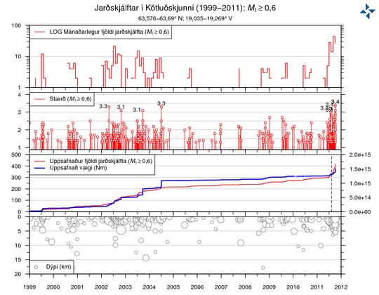
Heightened earthquake activity is presently occurring in the Katla volcano, southern Iceland. Earthquakes are taking place within the volcano's caldera, which is covered by the M?rdalsj?kull ice-cap. The current period of unrest began in July 2011, when a short-lived glacial flood burst from M?rdalsj?kull in connection with increased seismicity. Since then, several hundred micro-earthquakes have taken place within the area of the caldera. The enclosed graph shows how the ongoing activity compares to earlier episodes of seismic unrest at Katla in 1999 and 2002-2004.

In the early hours of today, 05 October 2011, an intense swarm of earthquakes was registered in the Katla caldera; the largest of these earthquake had a local magnitude of ~3.7. Most of the ongoing seismicity is sourced at shallow (< 5 km) depths.

There are presently no measurable signs that an eruption of Katla is imminent; however, given the heightened levels of seismicity, the situation might change abruptly. Monitoring teams at IMO are following the ongoing activity closely, and sensor-based networks around the volcano ensure that all seismological, geodetic, and hydrological changes are detected.
Historically, Katla is one of Iceland's most frequently erupting volcanoes.

The last eruption to break the ice surface of M?rdalsj?kull occurred in 1918, and it lasted about a month.

katla_cal_qu_new.png


http://en.vedur.is/about-imo/news/2011/nr/2360
 
Re: President of Iceland & Scientists Warn about Volcano Katla

jardskjalftar = Jarðskjálftar = earthquakes
http://twitter.com/#!/jardskjalftar

Kötluöskjunni = Katla Caldera

stærð = size


ask Icelandic volcanology experts for their subjective probability
estimates that Katla will erupt this year
 
Re: President of Iceland & Scientists Warn about Volcano Katla

Natural Disasters | 14.10.2011

As Icelandic volcano stirs, experts assess the risks of an eruption

Katla is widely considered to be Iceland's most-monitored volcano - and with good reason.

Icelandic scientists have warned that an eruption could trigger mass flooding, as well as a plume of fine ash that could cause a repeat of the travel disruptions that rocked the airline industry during the Eyjafjallaj?kull volcano's period of restlessness last year.

Now, new seismic data out of Iceland suggests that Katla could be roaring back to life.

A post published last week on Iceland's Meteorological Office (IMO) website pointed to an increase in seismic activity at Katla starting in July, including an "intense swarm" of earthquakes on October 5. Overall, hundreds of micro-earthquakes have been registered in Katla over the past few months.

But experts still aren't sure if that means Katla is getting ready to blow - and if it does erupt, whether they can expect a major event. The IMO was quick to point out that there was no cause for immediate alarm.
"There are presently no measurable signs that an eruption of Katla is imminent; however, given the heightened levels of seismicity, the situation might change abruptly," the office said in a statement on its website.

Katla's last major eruption was almost a century ago, in 1918. That eruption lasted less than a month, making it shorter than 2010's eruption of the Eyjafjallaj?kull volcano. Yet Katla averages two eruptions every 100 years, raising fears that it could be about to burst.

Read more:
http://www.dw-world.de/dw/article/0,,15460735,00.html
 
Back
Top Bottom