• FluTrackers.com Inc. does not provide medical advice. Information on this web site is collected from various internet resources, and the FluTrackers board of directors makes no warranty to the safety, efficacy, correctness or completeness of the information posted on this site by any author or poster. The information collated here is for instructional and/or discussion purposes only and is NOT intended to diagnose or treat any disease, illness, or other medical condition. Every individual reader or poster should seek advice from their personal physician/healthcare practitioner before considering or using any interventions that are discussed on this website. By continuing to access this website you agree to consult your personal physican before using any interventions posted on this website, and you agree to hold harmless FluTrackers.com Inc., the board of directors, the members, and all authors and posters for any effects from use of any medication, supplement, vitamin or other substance, device, intervention, etc. mentioned in posts on this website, or other internet venues referenced in posts on this website.
  • We are not asking for any donations. Do not donate to any entity who says they are raising funds for us.

NOAA Observations Indicate a Small Portion of Light Oil Sheen Has Entered the Loop Current

Re: NOAA Observations Indicate a Small Portion of Light Oil Sheen Has Entered the Loop Current

#20: "... said researchers can’t predict what oil or tar balls would do to the reef tract.
We haven’t done this experiment before,” ...
We’ll let you know after it’s over.”"


a typical "first we must do the experiment to know" logic


well, I think grassrootly we all can imagin what it will be with the spill affected reefs when toxic liquid oil blobs will stick onto the living polips of the reef ...

they (polip and algae) will be chocked, deprived of light/oxigen, and die

:yinyang:

http://www.coral.org/resources/about_coral_reefs/coral_overview

excerpt:
"Coral polyps eat in two different ways according to the species. Many coral polyps are nourished by a tiny algae called zooxanthellae (pronounced zo-zan-THEL-ee). The algae live within the coral polyps, using sunlight to make sugar for energy just like plants. Zooxanthellae process the waste of the polyp to retain important nutrients and in turn provide the polyp with oxygen. Meanwhile, the coral polyps provide the algae with carbon dioxide and a safe, protected home. Zooxanthellae living within the tissue of hard corals can supply them with up to 98 percent of their nutritional needs. Another way that corals eat is by catching tiny floating animals known as zooplankton. At night , coral polyps come out of their skeletons to feed, making the reef look like a wall of hungry mouths. The polyps stretch out their long, stinging tentacles to capture the zooplankton that are floating by. The captured plankton are then put into the polyps' mouths and digested in their stomachs."
 
Re: NOAA Observations Indicate a Small Portion of Light Oil Sheen Has Entered the Loop Current

AUDIO RELEASE: Jane Lubchenco teleconference call May 20, 2010


<TABLE style="WIDTH: 100%" cellSpacing=0 cellPadding=5 border=0><TBODY><TR><TD vAlign=top>

</TD></TR></TBODY></TABLE>ROBERT, La. - A teleconference call with NOAA Administrator Jane Lubchenco to discuss the BP oil spill?s trajectory in relation to the Loop Current and preparations for NOAA research flight investigating the Loop Current.

To download the audio, CLICK HERE.

A transcript of this audio recording will be provided as soon as it is available.

For information about the response effort, visit www.deepwaterhorizonresponse.com.

http://www.deepwaterhorizonresponse.com/go/doc/2931/558183/
 
Re: NOAA Observations Indicate a Small Portion of Light Oil Sheen Has Entered the Loop Current

Scientists see sheen, tarballs near loop current

By JANET McCONNAUGHEY Associated Press Writer © 2010 The Associated Press
May 26, 2010, 6:39PM

NEW ORLEANS, La. — Scientists looking for tuna larvae report seeing globs of reddish oil up to six inches across at an edge of the loop current, in an oily sheen that appeared to stretch for miles.

The fast, warm current could carry the Gulf of Mexico oil spill to the Florida's Keys and Atlantic Coast.

Researcher Jim Franks, of the University of Southern Mississippi's Gulf Coast Research Lab, reported the flecks and globs ranging from about a half-inch to five or six inches across.

"All those flecks and globules we saw were ... associated with a thin, widespread sheen that appeared to stretch for miles," he said in a report called in late Tuesday by satellite phone and posted Wednesday on the Gulf Coast Research Lab's website.

snip

http://www.chron.com/disp/story.mpl/ap/tx/7023871.html
 
Re: NOAA Observations Indicate a Small Portion of Light Oil Sheen Has Entered the Loop Current

Ocean currents likely to carry oil along Atlantic coast

June 03, 2010

BOULDER—A detailed computer modeling study released today indicates that oil from the massive spill in the Gulf of Mexico might soon extend along thousands of miles of the Atlantic coast and open ocean as early as this summer. The modeling results are captured in a series of dramatic animations produced by the National Center for Atmospheric Research (NCAR) and collaborators.
<embed src="http://www.youtube.com/v/pE-1G_476nA&hl=en_US&fs=1&color1=0x2b405b&color2=0x6b8ab6&border=1" type="application/x-shockwave-flash" allowscriptaccess="always" allowfullscreen="true" width="500" height="405">
snip

“We have been asked if and when remnants of the spill could reach the European coastlines,” says Martin Visbeck, a member of the research team with IFM-GEOMAR, University of Kiel, Germany. “Our assumption is that the enormous lateral mixing in the ocean together with the biological disintegration of the oil should reduce the pollution to levels below harmful concentrations. But we would like to have this backed up by numbers from some of the best ocean models.”

The scientists are using the Parallel Ocean Program, which is the ocean component of the Community Climate System Model, a powerful software tool designed by scientists at NCAR and the Department of Energy. They are conducting the simulations at supercomputers based at the New Mexico Computer Applications Center and Oak Ridge National Laboratory.

The University Corporation for Atmospheric Research manages the National Center for Atmospheric Research under sponsorship by the National Science Foundation. Any opinions, findings and conclusions, or recommendations expressed in this publication are those of the author(s) and do not necessarily reflect the views of the National Science Foundation.


<hr class="hr-padded">http://www2.ucar.edu/news/ocean-currents-likely-to-carry-oil-spill-to-atlantic-coast
 
Re: NOAA Observations Indicate a Small Portion of Light Oil Sheen Has Entered the Loop Current

Oil Spill on Track to Reach Atlantic No Later Than October


By Alexandra Witze, Science News
June 17, 2010 |
1:26 pm |


BOULDER, Colorado — Oil gushing from the Deepwater Horizon site in the Gulf of Mexico will reach the Atlantic Ocean within six months, says oceanographer Synte Peacock. Exactly when is all down to an eddy that broke off of the infamous Loop Current southwest of Florida on June 12.

Peacock, of the National Center for Atmospheric Research in Boulder, Colorado, usually studies how the ocean’s water absorbs atmospheric gases. But after the Deepwater Horizon platform exploded April 20, she realized her computer models could be used to follow where the oil gushing from the seafloor might end up.

Her simulations, announced in a press release June 3, made headlines worldwide. No surprise: The simulations suggested that, once the oil became caught up in the Loop Current, it would be funneled into the Atlantic within weeks.

Talking with reporters at NCAR on June 14, Peacock explained how some news outlets misrepresented her work by glossing over a few major caveats. Most important, the work simulated the movement of dye (not viscous oil) injected in the upper layers of the ocean (not the deep seafloor) for a total of two months (not the ongoing no-end-in-sight disaster).

snip

Image: National Center for Atmospheric Research


Read More http://www.wired.com/wiredscience/2010/06/oil-spill-in-atlantic-by-october/?utm_source=feedburner&utm_medium=feed&utm_campaign=Feed%3A+wired%2Findex+%28Wired%3A+Index+3+%28Top+Stories+2%29%29&utm_content=Google+Feedfetcher#ixzz0r9c6cgfw
 
Re: NOAA Observations Indicate a Small Portion of Light Oil Sheen Has Entered the Loop Current

NOAA Models Long-Term Oil Threat to Gulf and East Coast Shoreline

July 2, 2010
NOAA has used modeling of historical wind and ocean currents to project the likelihood that surface oil from the Deepwater Horizon/BP oil spill will impact additional U.S. coastline. This modeling, part of NOAA?s comprehensive response to the unprecedented Gulf oil disaster, can help guide the ongoing preparedness, response and cleanup efforts.
shoreline_300.jpg
Probability of Shoreline Threat, as of Day 120, for a 33,000 barrels/day release for 90 days.
High resolution (Credit: NOAA)

?This NOAA model shows where oil may be likely to travel, thereby giving coastal states and communities information about potential threats of shoreline impacts. This kind of information should assist in the preparation of adequate preparedness measures,? said Jane Lubchenco, Ph.D., under secretary of commerce for oceans and atmosphere and NOAA administrator. ?NOAA is strongly committed to providing reliable information to the public and to responders at all levels.?
In the technical report being released today, the model?s results aggregate information from 500 distinct scenarios (model outcomes). Each assumes a 90-day oil flow rate of 33,000 barrels per day ? the net amount from the flow rate ceiling of 60,000 barrels per day (the lower bound is 35,000 barrels/day) minus the daily estimated amount being skimmed, burned, and/or collected by the Top Hat mechanism. The model also accounts for the natural process of oil ?weathering? or breaking down, and considers oil a threat to the shoreline if there is enough to cause a dull sheen within 20 miles of the coast. If, for example, 250 of the 500 scenarios indicated a shoreline threat for a particular area, the overall threat for that area would be a 50 percent probability.

Considering these factors, the NOAA model indicates:
  • The coastlines with the highest probability for impact (81 to 100 percent) extend from the Mississippi River Delta to the western panhandle of Florida where there has been and will likely continue to be oil impacts.
  • Along U.S. Gulf of Mexico shorelines, the oil is more likely to move east than west, with much of the coast of Texas showing a relatively low probability of oiling (ranging from less than one percent in southern Texas to up to 40 percent near the Louisiana border).
  • Much of the west coast of Florida has a low probability (20 percent down to less than one percent) of oiling, but the Florida Keys, Miami and Fort Lauderdale areas have a greater probability (61 to 80 percent) due to the potential influence of the Loop Current. Any oil reaching this area would have spent considerable time degrading and dispersing and would be in the form of scattered tar balls and not a large surface slick of oil.
  • There is a low probability of shoreline impacts from eastern central Florida up the Eastern Seaboard (20 percent diminishing to less than one percent). Potential impacts become increasingly unlikely north of North Carolina as the Gulf Stream moves away from the continental U.S. at Cape Hatteras. If oil does reach these areas, it will be in the form of tar balls or highly weathered oil.
The threat outlined in the model does not necessarily indicate that oil will come ashore. Whether or not oil comes ashore will depend upon wind and ocean currents at the time. In addition to these and other natural factors, booms and other countermeasures could be used to mitigate the actual coastal contact.
The modeling results released today are based on several simplifying assumptions. In particular, they do not start with the current footprint of the spill, but rather model the spill beginning at day one, based on historical weather and current patterns. Also, the analysis does not adjust for effects of dispersants on the volume, weathering and movement of oil on the water?s surface. To date, no significant amount of oil has entered the Loop Current.
NOAA will continue to closely monitor the movement of the oil slick and develop daily 72-hour forecast projections. NOAA will also produce updated models of the long-term outlook as new data are gathered.
Updated scenarios and more information about the model can be found at:
http://response.restoration.noaa.gov/deepwaterhorizon/longterm_outlook.
NOAA?s mission is to understand and predict changes in the Earth's environment, from the depths of the ocean to the surface of the sun, and to conserve and manage our coastal and marine resources. Visit us on Facebook.
On the Web

Long Term Oil Outlook Report, July 2, 2010 [PDF]

What to Expect in South Florida from the Deepwater Horizon/ BP Oil Spill Fact Sheet [PDF]

NOAA Sends Two Ships to Study Loop Current and Coastal Florida Waters

http://www.noaanews.noaa.gov/stories2010/20100702_longterm.html
 
Re: NOAA Observations Indicate a Small Portion of Light Oil Sheen Has Entered the Loop Current

Contact: Rachel Wilhelm

FOR IMMEDIATE RELEASE
Rachel.wilhelm@noaa.gov July 3, 2010

CLARIFICATION on the Current Threat to Florida Peninsula and Florida Keys from Deepwater Horizon/BP Oil Spill

The risk of weathered oil and tar balls from the Deepwater Horizon/BP oil spill coming to the Florida Peninsula and the Florida Keys remains low under current ocean and wind conditions. NOAA?s long-term projection model released yesterday focused on the possible long-term shoreline threats and not on current wind and ocean conditions in the Gulf of Mexico.

The model considers conditions that are typical for this time of year to evaluate long-term likelihood of threats to different shorelines. Current conditions, especially given the absence of a significant amount of Deepwater Horizon/BP oil from the loop current, indicate that immediate threats to the Florida Keys, Miami and Ft. Lauderdale areas remain low.

"This modeling provides a glimpse for planning purposes but does not represent what we're actually seeing on the ground right now," said Debbie Payton, NOAA oceanographer. "Right now, three things are contributing to a very low probability of oil threatening Florida Peninsula shorelines in the short term: no oil has been observed in the area near the loop current, the northern part of the loop current has 'pinched off' into a clockwise rotating eddy, and the present forecast for winds, currents and oil transport do not indicate any oil moving into the loop current area."

The Florida Peninsula Command Post (FPCP) continues to aggressively monitor the current footprint of the spill in relation to the Florida Peninsula and the Florida Keys. The observed outer edge of the spill today is approximately 390 miles from the Dry Tortugas and over 100 miles away from the loop current's present location. The monitoring program includes surface sentry vessels, regular aerial patrols, satellite imagery and other scientific observations.
Should the situation change, the FPCP has developed effective response plans and is prepared to rapidly implement those plans should the need arise.

For the latest information and updates on the response to the oil spill, please visit:

www.deepwaterhorizonresponse.com.

NOAA?s mission is to understand and predict changes in the Earth's environment, from the depths of the ocean to the surface of the sun, and to conserve and manage our coastal and marine resources. Visit us on online or on Facebook.

On the Web:


<DIR><DIR>NOAA Models Long-Term Oil Threat to Gulf and East Coast Shoreline
http://www.noaanews.noaa.gov/stories2010/20100702_longterm.html
More information about the models:
http://response.restoration.noaa.gov/deepwaterhorizon/longterm_outlook ?
What to Expect in South Florida from the Deepwater Horizon/ BP Oil Spill (fact sheet)
http://www.noaa.gov/factsheets/new%20version/what_to_expect_in_southflorida.pdf
NOAA Sends Two Ships to Study Loop Current and Coastal Florida Waters


</DIR></DIR>
http://www.noaanews.noaa.gov/stories2010/20100630_ships.html
 
Re: NOAA Observations Indicate a Small Portion of Light Oil Sheen Has Entered the Loop Current

DATE: July 30, 2010 11:40:25 CST

NOAA: Gulf?s Surface Oil Not a Threat to Southern Florida, Keys, and East Coast

Southern Florida, the Florida Keys, and the East Coast are not likely to experience any effects from the remaining oil on the surface of the Gulf as the oil continues to degrade and is hundreds of miles away from the loop current, according to a new NOAA analysis. This analysis assumes the Deepwater Horizon/BP wellhead will remained capped.


?For southern Florida, the Florida Keys, and the Eastern Seaboard, the coast remains clear,? said Jane Lubchenco, Ph.D., under secretary of commerce for oceans and atmosphere and NOAA administrator. ?With the flow stopped and the loop current a considerable distance away, the light sheen remaining on the Gulf?s surface will continue to biodegrade and disperse, but will not travel far.?


This latest analysis is part of NOAA?s ongoing work related to the Deepwater Horizon/BP response and recovery efforts, including aerial and satellite-based observations of surface oil and monitoring of the loop current.


Overflights in the past week found only scattered patches of light sheen near the Mississippi Delta ? an indication that aggressive efforts to capture the oil have been effective and that the remaining oil is naturally dispersing and biodegrading.


A large loop current eddy, called Eddy Franklin, has pinched off and detached from the loop current. As of July 25, Eddy Franklin was more than 100 miles from the nearest surface oil associated with the Deepwater Horizon BP source.


Until the loop current fully reforms, there is no clear way for oil to be transported to southern Florida or beyond, which is not projected to occur for several months. At that point, essentially all of the remaining surface oil will have dissipated.

 
Re: NOAA Observations Indicate a Small Portion of Light Oil Sheen Has Entered the Loop Current

If no more oil escapes into the Gulf before the well is permanently sealed, which is expected to occur in the next few weeks, then there will be no danger of the oil from the spill ever impacting the region, Allen added.

The reason: the Franklin Eddy, which broke off from the Loop Current between the wellhead and where the current flows south to the Straits of Florida, has ``created a hydraulic barrier.''

``The chances that oil will become entrained in the Loop Current are very, very low and will go to zero as we continue to control the leakage at the well with the cap and ultimately kill it,'' Allen said.

http://www.miamiherald.com/2010/07/30/1754740/thad-allen-oil-from-gulf-spill.html
 
Re: NOAA Observations Indicate a Small Portion of Light Oil Sheen Has Entered the Loop Current

According to NOAA's report, a large loop current eddy, called Eddy Franklin, has pinched off and detached from the loop current. As of July 25, Eddy Franklin was more than 100 miles from the nearest surface oil associated with the Deepwater Horizon BP source. Until the loop current fully reforms, there is no clear way for oil to be transported to southern Florida or beyond, which is not projected to occur for several months. At that point, essentially all of the remaining surface oil will have dissipated.

http://sports.espn.go.com/outdoors/saltwater/columns/story?columnist=brown_david&id=5424181
 
Re: NOAA Observations Indicate a Small Portion of Light Oil Sheen Has Entered the Loop Current

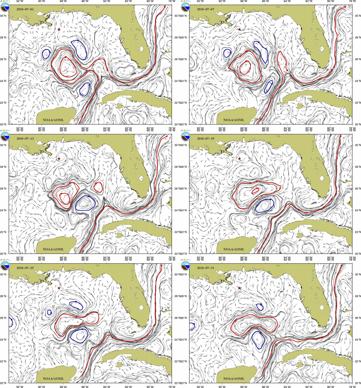
Current Ocean Conditions in the Gulf of Mexico

Why are these maps helpful?

These maps of ocean surface currents determined from satellite measurements provide information to scientists, decision makers, and emergency response personnel about the present oceanic flows and how they are changing with time.


The map below shows the latest estimate of the surface currents in the Gulf of Mexico. The red star indicates the location of the Deepwater Horizon. The solid contours indicate the location of the Loop Current and anticyclonic rings and eddies (red) and cyclonic eddies (blue).

...

Animation of the surface currents field:

JULY 2010


<CENTER></CENTER>
<SCRIPT language=JavaScript> <!-- resizeToImage(700,501); // --> </SCRIPT>
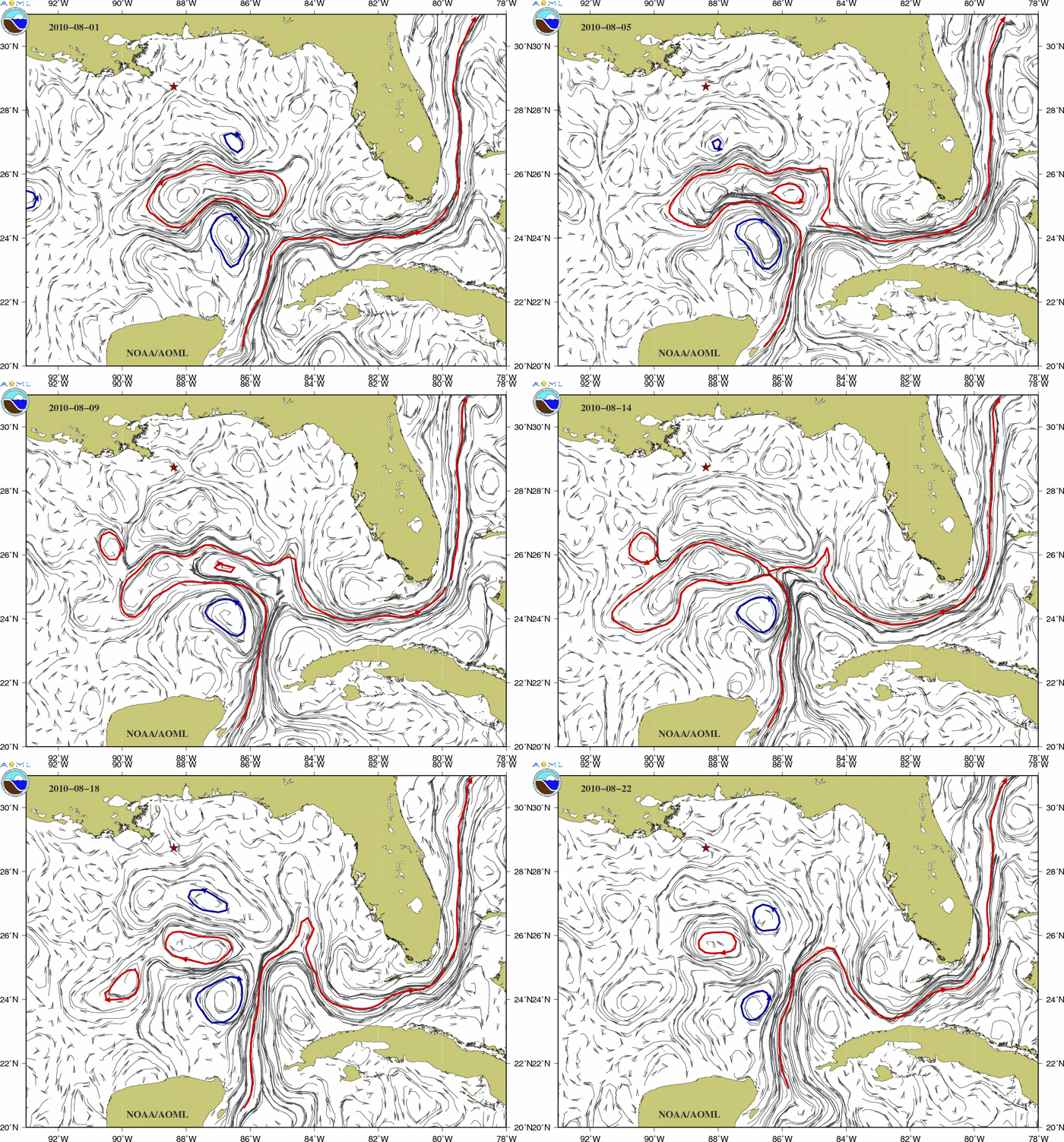


Animation of the surface currents field:

AUGUST 2010


<SCRIPT language=JavaScript> <!-- resizeToImage(700,501); // --> </SCRIPT>

http://www.aoml.noaa.gov/phod/dhos/geos.php
 
Back
Top