Announcement

Collapse
No announcement yet.

Tristan da Cunha region seismic activity

Collapse
X
 
  • Filter
  • Time
  • Show
Clear All
new posts

  • Tristan da Cunha region seismic activity

    Earthquakes


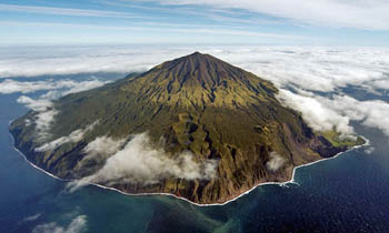
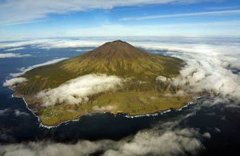
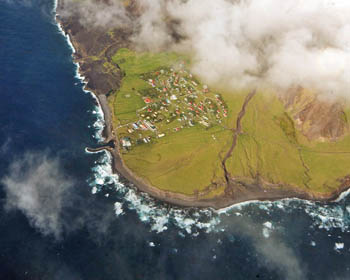
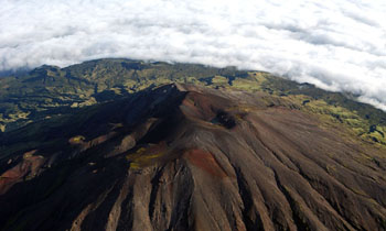
    Total features returned: 3 <TABLE border=1><TBODY><TR><TH>Location</TH><TH>Mag.</TH><TH>Time</TH></TR><TR></TR><TR><TD>Tristan da Cunha region</TD><TD>5.1</TD><TD>2010-01-27T12:31:36Z</TD><TR></TR><TR><TD>Tristan da Cunha region</TD><TD>5.2</TD><TD>2010-01-27T11:20:36Z</TD><TR></TR><TR><TD>Tristan da Cunha region</TD><TD>5.5</TD><TD>2010-01-26T15:22:05Z</TD></TR></TBODY></TABLE>


  • #2
    Re: Tristan da Cunha region seismic activity

    <TABLE cellSpacing=0 cellPadding=0><TBODY><TR><TD vAlign=top colSpan=2>Photographs from HMS Endurance's Helicopter taken on 12th April 2007

    </TD></TR><TR><TD vAlign=top width=366>

    </TD><TD vAlign=top width=370 rowSpan=2>

    </TD></TR><TR><TD vAlign=top width=366 rowSpan=2>Taken from the North-East showing ~

    Foreground : Rookery Point & behind The Ponds
    Far Left : Sandy Point
    Far Right : Hottentot Point & The Settlement


    Between Rookery Point & Hottentot Point ~
    note the distinct promontory of Big Point
    and beyond Pigbite and the black 1961 lava flow


    </TD></TR><TR><TD vAlign=top>Taken from the North-West showing ~

    Foreground: Boatharbour Bay and Hillpiece (obscured by cloud)
    Foreground left: Hottentot Point and The Settlement
    Foreground right: Patches Plain
    Behind the Patches Plain Tristan's highest cliffs rise sheer over 1500m
    towards Nellie's Hump and the Stone Castle


    </TD></TR><TR><TD vAlign=top width=366 rowSpan=2>

    </TD><TD vAlign=top>

    </TD></TR><TR><TD vAlign=top rowSpan=2>The 2060 m ~ 6760 ft Queen Mary's Peak from the NNE

    The heart-shaped summit crater is visible below The Peak,
    with Church Rock to the right
    A ridge runs south from The Peak to Mount Olav
    Visible in the distance left is Caves Gulch Hill
    and to its right Soggy Plain and Green Hill
    Note the contrast between the grey bare volcanic ash of the peak cinders, with only a sparse covering of lichens and mats of island berry
    and the green of the lower base, clothed in dwarf tree ferns and the island trees.


    </TD></TR><TR><TD vAlign=top width=366>Vertical view above Hottentot Point showing also ~
    The dry course of Hottentot Gulch
    Far Right: Crawford Point and above The Goat Ridge
    Centre : The Settlement of Edinburgh of the Seven Seas
    with the White roofed Fishing Factory above Calshot Harbour


    </TD></TR></TBODY></TABLE>

    <TABLE cellSpacing=0 cellPadding=0><TBODY><TR><TD vAlign=top width=366>

    </TD><TD vAlign=top>

    </TD></TR><TR><TD vAlign=top width=366>View from the east :

    Showing the Tristan Settlement
    with the 1961 Volcanic cone and lava flow in front
    and The Goat Ridge back left


    </TD><TD vAlign=top>Typical mountain ridge

    ridges radiate from the central peak
    sloping from the snow-covered stony upper slopes
    towards the lower base slopes


    </TD></TR><TR><TD vAlign=top width=366>

    </TD><TD vAlign=top>
    The Top Pond
    Smallest of the three Ponds - these features are unusual explosion craters, now linked by flowing streams which form depressions in the gently sloping north-eastern part of the base.
    There are five other crater lakes on the Tristan mountain, all within conventional raised volcanic parasitic cones known as parasitic cones, as well as the summit crater lake, making 9 in total


    </TD></TR></TBODY></TABLE>http://www.tristandc.com/aerialtristan.php


    Tristan da Cunha

    The World's Most Remote Island

    <Q></Q>
    Map of Tristan da Cunha's Location

    By Matt Rosenberg

    Located about midway between Cape Town, South Africa and Buenos Aires, Argentina lies what is often referred to as the world's most remote inhabited island - Tristan da Cunha. Tristan da Cunha is the primary island of the Tristan da Cunha island group, consisting of six islands at approximately 37?15' South, 12?30' West. That's about 1,500 miles (2,400 kilometers) west of South Africa in the South Atlantic Ocean.

    The other five islands in the Tristan da Cunha group are uninhabited, save for a manned meteorological station on the southernmost island of Gough. In addition to Gough, located 230 miles SSE of Tristan da Cunha, the chain includes

    Inaccessible at 20 miles (32 km) WSW, Nightingale 12 miles (19 km) SE, and Middle and Stoltenhoff islands - both just off the coast of Nightingale. The total area for all six islands amounts to a mere 52 mi2 (135 km2). The Tristan da Cunha islands are administered as part of the United Kingdom's colony of Saint Helena (1180 miles or 1900 km to the north of Tristan da Cunha).


    The circular island of Tristan da Cunha is approximately 6 miles (10 km) wide with a total area of 38 mi<SUP>2</SUP> (98 km<SUP>2</SUP>) and a coastline of 21 miles. The island group lies on the Mid-Atlantic Ridge and was created by volcanic activity. Queen Mary's Peak (6760 feet or 2060 meters) on Tristan da Cunha is an active volcano that last erupted in 1961, causing the evacuation of Tristan da Cunha's residents.

    Today, just under 300 people call Tristan da Cunha home. They live in the settlement known as Edinburgh that lies on the flat plain on the north side of the island. The settlement was named in honor of Prince Alfred, the Duke of Edinburgh, upon his visit to the island in 1867.

    Tristan da Cunha was named for Portuguese sailor Tristao da Cunha who discovered the islands in 1506 and although he was unable to land (the island of Tristan da Cunha is surrounded by 1000-2000 foot/300-600 meter cliffs), he named the islands after himself.

    The first inhabitant of Tristan da Cunha was American Jonathan Lambert of Salem, Massachusetts who arrived in 1810 and renamed the islands the Islands of Refreshment. Unfortunately, Lambert drowned in 1812.
    In 1816 the United Kingdom claimed and began to settle the islands. A handful of people were joined by the occasional shipwreck survivor over the next few decades and in 1856 the island's population was 71.

    However, the next year starvation caused many to flee leaving a population of 28 on Tristan da Cunha.

    The island's population fluctuated and eventually rose to 268 before the island was evacuated during the eruption of 1961. The evacuees went to England where some died due to the harsh winters and some women married British men. In 1963, almost all of the evacuees returned since the island was safe. However, having tasted the life of the United Kingdom, 35 left Tristan da Cunha for Europe in 1966.

    Since the 1960s, the population swelled to 296 in 1987. The 296 English-speaking residents of Tristan da Cunha share a mere seven surnames - most of the families have a history of being on the island since the early years of settlement.

    Today, Tristan da Cunha includes a school, hospital, post office, museum, and a crayfish canning factory. The issuance of postage stamps is a major source of revenue for the island. The self-supporting residents fish, raise livestock, make handicrafts, and grow potatoes. The island is visited annually by RMS St. Helena and more regularly by fishing vessels. There is no airport or landing field on the island.

    Species not found anywhere else in the world inhabit the island chain. Queen Mary's Peak is shrouded by clouds most of the year and snow covers its peak in the winter. The island receives an average of 66 inches (1.67 meters) of rain each year.

    Comment

    Working...
    X