Announcement

Collapse
No announcement yet.

Arctic freeze and snow wreak havoc across the planet

Collapse
X
 
  • Filter
  • Time
  • Show
Clear All
new posts

  • Arctic freeze and snow wreak havoc across the planet

    Originally posted by M.M., news text #1
    Guo Hu, the head of the Beijing Meteorological Bureau, linked this week’s conditions to unusual atmospheric patterns caused by global warming.


    China blames freak snow storm and record low temperatures on “global warming”

    Posted by CM on January 5, 2010
    It looks as though 2010 could be a record year for silly ’scientific’ statements, as meteorologists around the world clutch at straws trying to explain why the planet stubbornly refuses to behave the way it should. If this isn’t a classic case of climate scientists trying to have it all their own way, I don’t know what is.
    From the Sidney Morning Herald: Freak snowstorms and record low temperatures sweeping northern China are linked to global warming, say Chinese officials. But, unlike the unseasonal snow falls that hit Beijing at the start of winter, the dump this week appears to have no link to the Government’s relentless efforts to change the micro climate. There are about 2000 weather modification offices in China, according to the media, which are responsible for bombing the skies with silver iodide to induce precipitation.
    More than 2 million Beijing and Tianjin students were given the day off school yesterday because traffic was in chaos. On Sunday the capital received its biggest snow dump since 1951, immediately followed by the harshest Siberian winds in decades. Tomorrow morning the mercury is forecast to plunge to minus 16, a 40-year low, after a day-time maximum of minus 8.
    The head of the Beijing Meteorological Bureau, Guo Hu, linked the blizzard-like conditions this week to unusual atmospheric patterns caused by global warming.
    ”In the context of global warming, extreme atmospheric flows are causing extreme climate incidents to appear more frequently, such as the summer’s rain storms and last year’s icestorm disaster in southern China,” Mr Guo told Beijing News. Beijing winters are normally cold but arid, with most years recording only a light dusting of snow. On Sunday most of Beijing recorded between 10 and 20 centimetres of snow.
    The silliness continues here


    Posted in Uncategorized | Leave a Comment »

    UAH Global Temperature Update +0.28C

    Posted by CM on January 5, 2010

    The global-average lower tropospheric temperature anomaly fell back to the October level of +0.28 deg. C in December. The tropics continue warm from El Nino conditions there, while the NH and SH extratropics anomalies cooled from last month. While the large amount of year-to-year variability in global temperatures seen in the plot makes it difficult to provide meaningful statements about long-term temperature trends in the context of global warming, the running 25-month average suggests there has been no net warming in the last 11 years or so.
    [NOTE: These satellite measurements are not calibrated to surface thermometer data in any way, but instead use on-board redundant precision platinum resistance thermometers carried on the satellite radiometers.]
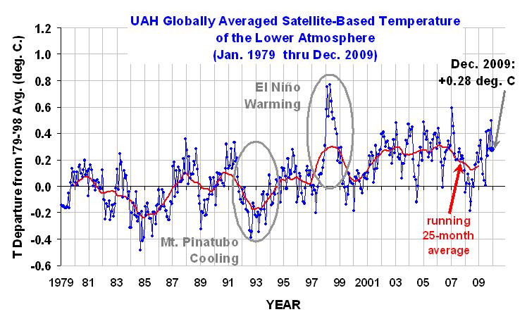
    Source: Dr. Roy Spencer
    ____
    ____

    About sat. radiometers, calibrations and errors:


    <table class="text" width="100&#37;" align="center" border="0" cellpadding="0" cellspacing="0"> <tbody><tr> <td colspan="3"> Chapter 6 - Temperature, Salinity, and Density<!-- InstanceBeginEditable name="CHAPTER NUM" --><!-- InstanceEndEditable --><!-- InstanceBeginEditable name="CHAPTER TITLE" --><!-- InstanceEndEditable -->

    <table width="450px" align="center" bgcolor="#99ccff" border="2" bordercolor="#000066" cellpadding="5" cellspacing="0"> <tbody><tr> <td class="subtitle">
    Chapter <!-- InstanceBeginEditable name="CHAPTER NUMBER" -->6<!-- InstanceEndEditable --> Contents
    </td> </tr> <tr> <td class="section">
    </td> </tr> </tbody></table> <!-- InstanceBeginEditable name="PRETEXT" --><!-- InstanceEndEditable --> <!-- InstanceBeginEditable name="SECTION NUMBER" -->

    6.6<!-- InstanceEndEditable --> <!-- InstanceBeginEditable name="SECTION NAME" -->Measurement of Temperature<!-- InstanceEndEditable -->
    <!-- InstanceBeginEditable name="BODY TEXT" --> Temperature in the ocean has been measured many ways. Thermistors and mercury thermometers are commonly used on ships and buoys. These are calibrated in the laboratory before being used, and after use if possible, using mercury or platinum thermometers with accuracy traceable to national standards laboratories. Infrared radiometers on satellites measure the ocean's surface temperature.


    Mercury Thermometer
    This is the most widely used, non-electronic thermometer. It was widely used in buckets dropped over the side of a ship to measure the temperature of surface waters, on Nansen bottles to measure subsea temperatures, and in the laboratory to calibrate other thermometers. Accuracy is about &#177; 0.001&#176;C with careful calibration.


    One very important mercury thermometer is the reversing thermometer (Figure 6.11) carried on Nansen bottles, which are described in the next section. It is a thermometer that has a constriction in the mercury capillary that causes the thread of mercury to break at a precisely determined point when the thermometer is turned upside down. The thermometer is lowered deep into the ocean in the normal position; and it is allowed to come to equilibrium with the water. Mercury expands into the capillary, and the amount of mercury in the capillary is proportional to temperature. The thermometer is then flipped upside down, the thread of mercury breaks trapping the mercury in the capillary, and the thermometer is brought back. The mercury in the capillary of the reversed thermometer is read on deck along with the temperature of a normal thermometer, which gives the temperature at which the reversed thermometer is read. The two readings give the temperature of the water at the depth where the thermometer was reversed.
    <table width="100%" align="center" border="0" cellpadding="0" cellspacing="10"> <tbody><tr> <td width="50%">
    </td> <td class="caption">Figure 6.11 Left: Protected and unprotected reversing thermometers is set position, before reversal. Right: The constricted part of the capillary in set and reversed positions. From von Arx (1962).</td> </tr> </tbody></table> The reversing thermometer is carried inside a glass tube which protects the thermometer from the ocean's pressure because high pressure can squeeze additional mercury into the capillary. If the thermometer is unprotected, the apparent temperature read on deck is proportional to temperature and pressure at the depth where the thermometer was flipped A pair of protected and unprotected thermometers gives temperature and pressure of the water at the depth the thermometer was reversed.
    Pairs of reversing thermometers carried on Nansen bottles were the primary source of subsea measurements of temperature as a function of pressure from around 1900 to 1970.


    Platinum Resistance Thermometer
    This is the standard for temperature. It is used by national standards laboratories to interpolate between defined points on the practical temperature scale. It is used primarily to calibrate other temperature sensors.


    Thermistor
    A thermistor is a semiconductor having resistance that varies rapidly and predictably with temperature. It has been widely used on moored instruments and on instruments deployed from ships since about 1970. It has high resolution and an accuracy of about &#177; 0.001&#176;C when carefully calibrated.


    Bucket temperatures The temperature of surface waters has been routinely measured at sea by putting a mercury thermometer into a bucket which is lowered into the water, letting it sit at a depth of about a meter for a few minutes until the thermometer comes to equilibrium, then bringing it aboard and reading the temperature before water in the bucket has time to change temperature. The accuracy is around 0.1&#176;C. This is a very common source of direct surface temperature measurements.
    Ship Injection Temperature The temperature of the water drawn into the ship to cool the engines has been recorded routinely for decades. These recorded values of temperature are called injection temperatures. Errors are due to ship's structure warming water before it is recorded. This happens when the temperature recorder is not placed close to the point on the hull where water is brought in. Accuracy is 0.5&#176;-1&#176;C.


    Advanced Very High Resolution Radiometer
    The most commonly used instrument to measure sea-surface temperature from space is the Advanced Very High Resolution Radiometer AVHRR. The instrument has been carried on all polar-orbiting meteorological satellites operated by NOAA since Tiros-N was launched in 1978.
    The instrument was originally designed to measure cloud temperatures and hence cloud height. The instrument had, however, sufficient accuracy and precision that it was soon used to measure regional and global temperature patterns at the sea surface.
    The instrument is a radiometer that converts infrared radiation into electrical signals. It includes a mirror that scans from side to side across the subsatellite track and reflects radiance from the ground into a telescope, a telescope that focuses the radiance on detectors, detectors sensitive to different wavelengths that convert the radiance at those wavelengths into electrical signals, and electronic circuitry to digitize and store the radiance values. The instruments observes a 2700-km wide swath centered on the subsatellite track. Each observation along the scan is from a pixel that is roughly one kilometer in diameter near the center of the scan and that increases in size with distance from the subsatellite track.
    The radiometers measures infrared radiation emitted from the surface in five wavelength bands: three infrared bands: 3.55–3.93 &#181;m, 10.30–11.30 &#181;m, and 11.50–12.50 &#181;m; a near-infrared band at 0.725–1.00 &#181;m; and a visible-light band at 0.58–0.68 &#181;m. All infrared bands include radiation emitted from the sea and from water vapor in the air along the path from the satellite to the ground. The 3.7 &#181;m band is least sensitive to water vapor and other errors, but it works only at night because sunlight has radiance in this band. The two longest wavelength bands at 10.8 &#181;m and 12.0 &#181;m are used to observe sea-surface temperature and water vapor along the path in daylight.
    Data with 1-km resolution are transmitted directly to ground stations that view the satellite as it passes the station. This is the Local Area Coverage mode. Data are also averaged to produce observations from 4km &#215; 4km pixels. These data are stored on tape recorders and later transmitted to NOAA receiving stations. This is the Global Area Coverage mode.
    The swath width is sufficiently wide that the satellite views the entire Earth twice per day, at approximately 09:00 AM and 9:00 PM local time. Areas at high latitudes may be observed as often as eight or more times per day.

    The most important errors are due to:

      1. Unresolved or undetected clouds: Large, thick clouds are obvious in the images of water temperature Thin clouds such as low stratus and high cirrus produce much small errors that are difficult or almost impossible to detect. Clouds smaller in diameter than 1km, such as trade-wind cumuli, are also difficult to detect. Special techniques have been developed for detecting small clouds (Figure 6.12).
      2. Water vapor, which absorbs part of the energy radiated from the sea surface: Water vapor reduces the apparent temperature of the sea surface. The influence is different in the 10.8 &#181;m and 12.0 &#181;m channels, allowing the difference in the two signals to be used to reduce the error.
      3. Aerosols, which absorb infrared radiation. They radiate at temperatures found high in the atmosphere. Stratospheric aerosols generated by volcanic eruptions can lower the observed temperatures by up to a few degrees Celsius. Dust particles carried over the Atlantic from Saharan dust storms can also cause errors.
      4. Skin temperature errors. The infrared radiation seen by the instrument comes from a layer at the sea surface that is only a few micrometers thick. The temperature in this layer is not quite the same as temperature a meter below the sea surface. They can differ by several degrees when winds are light (Emery and Schussel, 1989). This error is greatly reduced when AVHRR data are used to interpolate between ship measurements of surface temperature.


    <table width="100%" align="center" border="0" cellpadding="0" cellspacing="10"> <tbody><tr> <td></td> <td class="caption" width="50%">Figure 6.12 The influence of clouds on infrared observations. Left: The standard deviation of the radiance from small, partly cloudy areas each containing 64 pixels. The feet of the arch-like distribution of points are the seasurface and cloud-top temperatures. (After Coakley and Bretherton (1982)). Right: The maximum difference between local values of t<sub>11</sub>- t<sub>3.7</sub> and the local mean values of the same quantity. Values inside the dashed box indicate cloud-free pixels. t<sub>11</sub> and t<sub>3.7</sub> are apparent temperatures at 11.0 &#181;m and 3.7 &#181;m (data from K. Kelly). From Stewart (1985).</td> </tr> </tbody></table> Maps of temperature processed from Local Area Coverage of cloud-free regions show variations of temperature with a precision of 0.1&#176;C. These maps are useful for observing local phenomena including patterns produced by local currents. Figure 10.16 shows such patterns off the California coast.
    Global maps are made by the U. S. Naval Oceanographic Office, which receives the global AVHRR data directly from NOAA's National Environmental Satellite, Data and Information Service in near-real time each day. The data are carefully processed to remove the influence of clouds, water vapor, aerosols, and other sources of error. Data are then used to produce global maps between &#177; 70&#176; with an accuracy of &#177; 0.6&#176;C (May et a.,l 1998). The maps of sea-surface temperature are sent to the U.S. Navy and to NOAA's National Centers for Environmental Prediction. In addition, the office produces daily 100km global and 14km regional maps of temperature.
    Global Maps of Sea-Surface Temperature
    Global, monthly maps of surface temperature are produced by the National Centers for Environmental Prediction using Reynolds (1988, 1993, 1994) optimal-interpolation method. The technique blends ship and buoy measurements of sea-surface temperature with AVHRR data processed by the Naval Oceanographic Office in 1&#176; areas for a month. Essentially, AVHRR data are interpolated between buoy and ship reports using previous information about the temperature field. Overall accuracy ranges from approximately &#177; 0.3&#176;C in the tropics to &#177; 0.5&#176;C near western boundary currents in the northern hemisphere where temperature gradients are large. Maps are available from November 1981. Figures 6.2 - 6.4 were made by NOAA using Reynolds' technique.
    Maps of mean temperature have also been made from ICOADS data. The data are poorly distributed in time and space except for some areas of the northern hemisphere. In addition, Reynolds and Smith (1994) found that ship temperature data had errors twice as large as temperature errors in data from buoys and AVHRR. Thus, space data processed by Reynolds are more accurate, and better distributed than ICOADS.
    Anomalies of sea-surface temperature are calculated using mean sea-surface temperature from the period 1950-979 calculated from ICOADS supplemented with four years of satellite data 1982-1985 (Reynolds and Smith, 1995).
    <!-- InstanceEndEditable --> chapter contents

    </td> </tr> <tr valign="middle" align="center"> <td>
    </td> <td class="footer">Department of Oceanography, Texas A&M University
    Robert H. Stewart, stewart@ocean.tamu.edu
    All contents copyright &#169; 2005 Robert H. Stewart,
    All rights reserved
    Updated on <!-- #BeginDate format:Am1 -->September 15, 2008<!-- #EndDate --></td> <td>
    </td> </tr> </tbody></table> <!-- InstanceEnd -->

  • #2
    Re: Arctic freeze and snow wreak havoc across the planet

    It is 36 F in the Orlando area now. I think the high in my area was 37 F today. Tonight will the 2nd consecutive night below freezing.

    Weather Underground provides local & long-range weather forecasts, weather reports, maps & tropical weather conditions for locations worldwide

    Comment


    • #3
      Re: Arctic freeze and snow wreak havoc across the planet

      By Sara K. Clarke, Orlando Sentinel 9:52 a.m. EST, January 10, 2010


      FHP: Northbound lanes of U.S. 1 in Titusville closed due to ice


      Florida Highway Patrol is reporting a road closure in Titusville due to ice.

      The agency said the northbound lanes of U.S. 1 near East Cheney Highway in Brevard County are closed because to ice.


      snip

      Comment


      • #4
        Re: Arctic freeze and snow wreak havoc across the planet

        Louisiana

        Homeless, citrus growers among those struggling to deal with cold

        By Richard Thompson, The Times-Picayune

        January 09, 2010, 7:00PM

        Chris Granger, The Times-PicayuneFrank Gordon, far left, squats to take a picture of ice covered landscaping at City Park the morning that temperatures hovered in the 20s on Saturday.

        Despite a bitter cold that dipped well below freezing for several hours Saturday morning, David Dunhardt wasn't swayed to pack up his tent and wait for a bed at the nearby New Orleans Mission, one of several homeless shelters in the city that had beefed up their capacity for the weekend cold snap with portable cots.

        "If it was good enough for George Washington, it was good enough for us," Dunhardt, 42, one of a dozen homeless people who braved the mid-20s temperatures in a parking lot on Oretha Castle Haley Boulevard, said about spending the night outdoors.

        Forecasters expect the arctic air to remain over the region until early in the week, and the National Weather Service issued a hard-freeze warning for the south shore of Lake Pontchartrain through 9 a.m. Sunday.

        Amid the frigid temperatures, the coldest this far south in Louisiana since
        February 1996, nearly 9,800 homes and businesses were left in the dark Friday night because of a power outage in parts of St. Tammany and Tangipahoa parishes, said WST Electric spokeswoman Coylean Schloegel.
        Although power was restored Saturday to those affected, an additional 1,500 customers reported they lost power later in the day, said Schloegel, who attributed the incidents to overall strain on the system.
        Susan Poag, The Times-PicayuneWorkers at Ben & Ben Becnel,Inc. citrus growers rapidly try to get fruit off the trees Thursday.

        Elsewhere across the region, citrus growers in Plaquemines Parish were crossing their fingers after spending the past few days scrambling to harvest the parish's $15 million crop and brace their trees against the unseasonably cold weather.

        "Everything seems to be OK," said Sandy Becnel Palmer of Becnel's Stix-N-Stems Nursery in Belle Chasse, where a trio of workers spent three days picking fruit from the nursery's 580 trees, then packing it into 40-pound crates and putting it in a heated barn for safekeeping.

        At Ben & Ben Becnel Inc., a major fruit and vegetable grower in Plaquemines that owns about 5,000 trees, 14 workers spent five days harvesting and storing as much as 90 percent of the crop. "Fortunately, we had enough of our workers that we were able to do it just within the normal workday," Ben Becnel Jr. said. "Just picking as fast as we could and stacking them in the barn."

        The cold weather also caused a water main to burst Saturday in the Marrero and Harvey area, though Deano Bonano, Jefferson Parish's emergency management director, said no streets were closed as a result.

        Two shelters remained open in St. Tammany Parish, operated with the assistance of the Red Cross and the faith-based community at First Baptist Church of Mandeville and Northside Baptist Church near Slidell, parish spokeswoman Suzanne Parsons Stymiest said.

        Jefferson Parish hadn't opened a shelter as of Saturday afternoon but might do so should the parish receive a large number of calls for help, officials said.

        In New Orleans, caseworkers for the homeless reserved most of their dwindling stash of winter coats on Friday night for holdouts squatting inside the city's thousands of abandoned buildings.

        Teams from UNITY of Greater New Orleans and the New Orleans Police Department's homeless-outreach arm were able to take most of the homeless people they found on the streets to shelters. Some normally homeless individuals seemed to have found shelter from the life-threatening cold with relatives or friends. But many of the squatters who remained in abandoned houses were steadfast about staying in their jury-rigged tents and nests of blankets, said Martha Kegel, executive director of UNITY.

        Caseworkers were able to coax at least one woman whom they'd never known to sleep indoors to go to a shelter, but about nine out of 10 squatters refused to leave their hideouts, Kegel said.

        UNITY estimates that 6,000 people are living out of sight in New Orleans' blighted and abandoned buildings. Many of them are in frail health and have serious mental illnesses -- in many cases worse than those who seek out services at soup kitchens, shelters and drop-in centers.

        As part of the city's freeze plan, the city's handful of homeless shelters -- the Ozanam Inn, New Orleans Mission, Salvation Army Center of Hope, Covenant House New Orleans and Bridge House -- were allowed to expand their capacity to 686 beds for the cold spell, but all have been crammed full since Wednesday night.

        About 50 additional people slept inside a newly created public shelter Friday night after the city, in cooperation with the Red Cross, set up cots inside the Allie Mae Williams Multi-Service Center at Jackson and Simon Bolivar avenues. That shelter, open to anyone without shelter or heat where they normally sleep, is scheduled to remain open through Monday morning, if needed.

        Staff writer Katy Reckdahl contributed to this report.

        Comment


        • #5
          Re: Arctic freeze and snow wreak havoc across the planet

          From The Times

          January 9, 2010
          Weather eye: Cold Arctic weather sweeps across Europe and Asia
          ...

          While one part of the globe shivers, other regions are basking in the sun. The Mediterranean, Alaska and northern Canada are unseasonably warm, and heatwaves are roasting Australia. Parts of the Pacific are 3C above average.

          There is a redistribution of warm and cold air around different parts of the world — but the overall global temperature is staying much the same.[/quote]

          [size=3]Excerpt:

          "How are Global Warming and the Gulf Stream Connected?

          If melting glaciers deflect warm Gulf Stream, U.S. and Europe may freeze


          By Larry West, About.com Guide
          ...

          Gulf Stream Disruption Could Freeze Europe and North America

          Computer models simulating ocean-atmosphere climate dynamics indicate that the North Atlantic region would cool between three and five degrees Celsius if Conveyor circulation were totally disrupted. It would produce winters twice as cold as the worst winters on record in the eastern United States in the past century,” says Robert Gagosian of the Woods Hole Oceanographic Institution.

          Gulf Stream Linked to Previous Temperature Changes
          The slowing of the Gulf Stream has been directly linked with dramatic regional cooling before, says McGuire. “Just 10,000 years ago, during a climatic cold snap known as the Younger Dryas, the current was severely weakened, causing northern European temperatures to fall by as much as 10 degrees Fahrenheit,” he says. And 10,000 years earlier—at the height of the last ice age when most of northwestern Europe was a frozen wasteland—the Gulf Stream had just two-thirds of the strength it has now"


          from:

          http://environment.about.com/od/glob...ulf_stream.htm


          _____


          http://environment.about.com/od/globalwarmingandweather/a/gulf_stream.htm


          How are Global Warming and the Gulf Stream Connected?
          If melting glaciers deflect warm Gulf Stream, U.S. and Europe may freeze


          By Larry West, About.com Guide


          Dear EarthTalk: What is the issue with the Gulf Stream in relation to global warming? Could it really stop or disappear altogether? If so, what are the ramifications of this? -- Lynn Eytel, Clark Summit, PA Part of the Ocean Conveyor Belt—a great river of ocean water that traverses the saltwater sections of the globe—the Gulf Stream stretches from the Gulf of Mexico up the eastern seaboard of the United States, where it splits, one stream heading for Canada’s Atlantic coast and the other for northern Europe and Greenland. By taking warm water from the equatorial Pacific Ocean and carrying it into the colder North Atlantic, the Gulf Stream warms up the eastern United States and northwestern Europe by about five degrees Celsius (roughly nine degrees Fahrenheit), making those regions much more hospitable than they would be otherwise.
          Melting Glaciers Could Disrupt Warm Gulf Stream Currents
          Among the greatest fears scientists have about global warming is that it will cause the massive ice fields of Greenland and other locales at the northern end of the Gulf Stream to melt rapidly, sending surges of cold water into the ocean system and interrupting the flow of the Ocean Conveyor Belt. One doomsday scenario is that such an event would stop or disrupt the whole Ocean Conveyor Belt system, plunging Western Europe into a new ice age without the benefit of the warmth delivered by the Gulf Stream.
          Gulf Stream May Affect Climate Change Worldwide
          “The possibility exists that a disruption of the Atlantic currents might have implications far beyond a colder northwest Europe, perhaps bringing dramatic climatic changes to the entire planet,” says Bill McGuire, a geophysical hazards professor at University College London’s Benfield Hazard Research Centre.

          Gulf Stream Disruption Could Freeze Europe and North America
          Computer models simulating ocean-atmosphere climate dynamics indicate that the North Atlantic region would cool between three and five degrees Celsius if Conveyor circulation were totally disrupted. “It would produce winters twice as cold as the worst winters on record in the eastern United States in the past century,” says Robert Gagosian of the Woods Hole Oceanographic Institution.
          Gulf Stream Linked to Previous Temperature Changes
          The slowing of the Gulf Stream has been directly linked with dramatic regional cooling before, says McGuire. “Just 10,000 years ago, during a climatic cold snap known as the Younger Dryas, the current was severely weakened, causing northern European temperatures to fall by as much as 10 degrees Fahrenheit,” he says. And 10,000 years earlier—at the height of the last ice age when most of northwestern Europe was a frozen wasteland—the Gulf Stream had just two-thirds of the strength it has now.
          Could Weakened Gulf Stream Help Offset Global Warming?
          A less dramatic prediction sees the Gulf Stream slowing down but not stopping entirely, causing the east coast of North America and northwestern Europe to suffer only minor winter temperature dips. And some scientists even put forth the optimistic hypothesis that the cooling effects of a weakened Gulf Stream could actually help offset the higher temperatures otherwise caused by global warming.
          Global Warming: A Planetary Experiment
          To McGuire, these uncertainties underscore that fact that human-induced global warming is “nothing more nor less than a great planetary experiment, many of the outcomes of which we cannot predict.” Whether or not we can trim our addiction to fossil fuels might just be the determining factor in whether global warming wreaks havoc around the world, or just causes us minor annoyances.
          GOT AN ENVIRONMENTAL QUESTION? Send it to: EarthTalk, c/o E/The Environmental Magazine, P.O. Box 5098, Westport, CT 06881; submit it at: www.emagazine.com/earthtalk/thisweek/, or e-mail: earthtalk@emagazine.com.
          EarthTalk is a regular feature of E/The Environmental Magazine. Selected EarthTalk columns are reprinted on About Environmental Issues by permission of the editors of E.

          Comment


          • #6
            Re: Arctic freeze and snow wreak havoc across the planet

            4 more years gone ...

            ____

            From The Times
            <!-- BEGIN: Module - Advert:Top --> <script type="text/javascript"> <!-- //Get recommendations var wlrcmd= ""; var WlRnd = Math.floor(Math.random()*99999999999); var WlProtocol = location.protocol.indexOf('https')>-1?'https:':'http:'; var WlUrl= WlProtocol +'//rc.newsint.newscorp.individuad.net/Get/newsint/JS/GetRcmd.js?ord=' +WlRnd; document.write('<scr' + 'ipt language="JavaScript" src="' + WlUrl + '"></sc'+ 'ript>'); //--> </script><script language="JavaScript" src="http://rc.newsint.newscorp.individuad.net/Get/newsint/JS/GetRcmd.js?ord=70090306436"></script> <script type="text/javascript"> <!-- //Retrieve yaoo Cookie Value var yahoo = "no"; var IsYahoo="no"; if (GetQueryString("yahoo")=="yes" || get_cookie('YH') == "yes") IsYahoo="yes"; if (IsYahoo == "yes" || get_cookie('YH') == 'open') { set_cookie ("YH", "yes", "", "" ); yahoo = "yes"; } else { set_cookie ("YH", "no", "", "" ); yahoo = "no"; } window.onunload = setYahooCookie; //--> </script> <!-- For Travel Search --> <!--SECTION:parameter parameter="dart.server" /--> <!-- END: Module - Advert:Top -->
            December 1, 2005
            Britain faces big freeze as Gulf Stream loses strength

            The latest breaking UK, US, world, business and sport news from The Times and The Sunday Times. Go beyond today's headlines with in-depth analysis and comment.


            <!--CMA user Call Diffrenet Variation Of Image --> <!-- BEGIN: Module - M24 Article Headline with portrait image (c) --> <script type="text/javascript" src="http://www.timesonline.co.uk/tol/js/m24-image-browser.js"></script> <!-- BEGIN: Module - M24 Article Headline with portrait image (c) --> <script type="text/javascript"> <!-- /* Global variables that are used for "image browsing". Used on article pages to rotate the images of a story. */ var sImageBrowserImagePath = ''; var aArticleImages = new Array(); var aImageDescriptions = new Array(); var aImageEnlargeLink = new Array(); var aImageEnlargePopupWidth = '500'; var aImageEnlargePopupHeight = '500'; var aImagePhotographer = new Array(); var nSelectedArticleImage = 0; var i=0; //--> </script>

            By Mark Henderson, Science Correspondent

            <!-- BEGIN: M19 - Article tools --> <script type="text/javascript"> gSiteLife.Recommend("ExternalResource", "598464","http://www.timesonline.co.uk/tol/news/uk/article598464.ece"); </script>
            <!-- END: Module - Module - M24 Article Headline with pair of portrait images (c) --> <!-- BEGIN: Module - Main Article --> <!-- Check the Article Type and display accordingly--> <!-- Print Author image associated with the Author--> <!-- Print the body of the article--> <style type="text/css"> div#related-article-links p a, div#related-article-links p a:visited { color:#06c; } </style> <!-- Pagination --> <!--Display article with page breaks --> THE Gulf Stream currents that give Britain its mild climate have weakened dramatically, offering the first firm scientific evidence of a slowdown that threatens the country with temperatures as cold as Canada’s. The Atlantic Ocean “conveyor belt” that carries warm water north from the tropics has weakened by 30 per cent in 12 years, scientists have discovered. The findings, from the National Oceanography Centre in Southampton, give the strongest indication yet that Europe’s central heating system is breaking down under the impact of global warming.
            Scientists have long predicted that melting ice caps could disrupt the currents that keep Britain at least 5C (40F) warmer than it should be, but the new research suggests that this is already under way. It points to a cooling of 1C over the next decade or two, and an even deeper freeze could follow if the Gulf Stream system were to shut down altogether.
            The British Isles lie on the same latitude as Labrador on the East Coast of Canada, and are protected from a similarly icy climate by the Atlantic conveyor belt, which carries a million billion watts of heat. Although oceanographers still think it unlikely that the currents will stop completely, this could reduce average temperatures by between 4C and 6C in as little as 20 years, far outweighing any increase predicted as a result of global warming.
            Even a lesser fall in temperatures could mean that Britain gets colder even as the rest of the world warms up, and would severely disrupt the Government’s plans for mitigating the effects of climate change.
            <!--#include file="m63-article-related-attachements.html"--> <!-- BEGIN: Module - M63 - Article Related Attachements --> <script type="text/javascript" src="http://www.timesonline.co.uk/tol/js/picture-gallery.js"></script> <script type="text/javascript"> function slideshowPopUp(url) { pictureGalleryPopupPic(url); return false; } </script> <!-- BEGIN: Comment Teaser Module --> <!-- END: Comment Teaser Module --> <!-- BEGIN: Module - M63 - Article Related Package --> <!-- END: Module - M63 - Article Related Package --> Related Links


            <form name="relatedLinksform" action="" method="post"> </form>
            <form name="relatedLinksform" action="" method="post"> </form>
            <form name="relatedLinksform" action="" method="post"> </form> <form name="relatedLinksform" action="" method="post"> </form> <form name="relatedLinksform" action="" method="post"> </form>

            <!-- BEGIN: POLL --> <!--This block will execute if an article of type Poll is attached--> <!-- END : POLL --> <!-- BEGIN: DEBATE--> <!-- END: DEBATE-->
            <!-- END: Module - M63 - Article Related Attachements --> <!-- Call Wide Article Attachment Module --> <!--TEMPLATE:call file="wideArticleAttachment.jsp" /--> The Gulf Stream begins in the Gulf of Mexico and carries warm water north and east, through the straits of Florida and across the North Atlantic. Halfway across the ocean, it branches into two, with one current flowing south towards Africa and another drifting towards northern Europe. By the time the northern current reaches the Arctic, its waters have become colder and more saline, causing them to sink. A vast undersea river of cold water then flows back towards the Gulf.
            Global warming is predicted to disrupt this process, as extra freshwater from melting ice caps reduces the salinity of the Arctic waters, stopping it from sinking and breaking the circuit. The Southampton team measured current flow across a latitude of 250N. The original Gulf Stream, cold water returning from the Arctic, and the southern branch of warm water all cross this line stretching from North Africa to the Bahamas. Measurements taken last year were compared with data collected in 1957, 1981, 1992 and 1998.
            The results, published today in Nature, show that the outward flow of the Gulf Stream has not changed, but the strength of the cold water returning from the Arctic has fallen by 30 per cent since 1992. Over the same period, the flow of warm water branching off towards Africa has increased by 30 per cent. This suggests that the warm waters are being diverted away from Europe.
            Meric Srokosz, of the Natural Environment Research Council, which funded the work, said: “If it is persistent or there is a further decline then, yes, it would have an impact on the climate. The models suggest that if the change is persistent we might see the order of a 1C drop in temperature here over a decade or two.”
            It remains possible that flows change annually or seasonally and that the 1992 and 2004 data were aberrations. A project is under way to monitor Atlantic currents for four years.

            Comment


            • #7
              Re: Arctic freeze and snow wreak havoc across the planet

              Tropical - very pertinent article - you are right - 4 years down the track!

              Britain and China having trouble with food supplies and grit to keep roads clear.

              Crop failures, food prices soaring
              British Frozen out 5.4 billion a day
              (London, United Kingdom ‧ 11 AP) United Kingdom by the super-cold winds, crop failures led to food prices soaring, every day an estimated economic loss of 10 billion pounds (5.4 billion euros).

              England Center for Economic and Business Research predicted heavy snow will result in the UK suffer one billion pounds per day in economic losses. But economists and analysts believe that the real impact of snow on the economy can not be measured.

              Cold weather is expected to continue for 10 days, food supply, carrots skyrocketing price of 30%. People scramble for food like a festive Christmas Eve as the tense.

              Snow road closures, milk, transport difficulties, farmers estimated that as many as 10 million liters, or milk to be discarded down. Surge in demand for natural gas, but reserves are barely enough to 16 days to use.

              Is used to clear the roads and snow shortage of salt and coarse gravel, road traffic disruption, the number of deaths related to severe weather has increased to 26 people died of cold this winter to official estimates the number will exceed 4,000.

              London's Hyde Park 9 Lake Saturday was forced to close, this is first for 140 years. English Premier League and Super League rugby field and five respectively seven games were canceled.

              The Prime Minister held an emergency meeting

              British Prime Minister Gordon Brown has held an emergency meeting, said that importing natural gas from the North Sea to the public to ensure adequate supply. But the public is faced with ground and air traffic will be almost paralyzed predicament.

              China's largest salt company is expected that inventory will run out of salt, has seriously affected the work of clearing the snow, there are thousands of miles of roads will be paralyzed, millions of people trapped.

              Roads covered with snow, the Government Zhengchou lack of salt and coarse gravel clear the road, people may be in the "mind your own business", the way the snow clean-up public roads.

              However, under the existing legislation, if the clean-up improperly led to slipping injury, or will stay away from lawsuit. Therefore encouraged minding only their own, but experts and officials have criticized the law absurd.

              On the other hand, the UK's largest federation of employers said that Blizzard will not be a significant impact on economic recovery, because people just do not go out shopping and to work temporarily.

              Confederation of British Industry also said that thanks to the Internet easily accessible, people can shop online at any time, so the snow little impact on the UK economy.
              http://www.chinapress.com.my/content...12waa94a20.txt
              "The only security we have is our ability to adapt."

              Comment

              Working...
              X