
• FluTrackers.com Inc. does not provide medical advice. Information on this web site is collected from various internet resources, and the FluTrackers board of directors makes no warranty to the safety, efficacy, correctness or completeness of the information posted on this site by any author or poster. The information collated here is for instructional and/or discussion purposes only and is NOT intended to diagnose or treat any disease, illness, or other medical condition. Every individual reader or poster should seek advice from their personal physician/healthcare practitioner before considering or using any interventions that are discussed on this website. By continuing to access this website you agree to consult your personal physican before using any interventions posted on this website, and you agree to hold harmless FluTrackers.com Inc., the board of directors, the members, and all authors and posters for any effects from use of any medication, supplement, vitamin or other substance, device, intervention, etc. mentioned in posts on this website, or other internet venues referenced in posts on this website.
  • We are not asking for any donations. Do not donate to any entity who says they are raising funds for us.

US - Hurricane Milton - October 5+

000
WTNT64 KNHC 071305
TCUAT4

Hurricane Milton Tropical Cyclone Update
NWS National Hurricane Center Miami FL AL142024
805 AM CDT Mon Oct 07 2024


...MILTON RAPIDLY INTENSIFIES INTO A CATEGORY 4 HURRICANE...

Data from both Hurricane Hunter aircraft indicate that Milton has
strengthened to a category 4 hurricane. The maximum sustained
winds are estimated to be 150 mph
(240 km/h). Milton is a category
4 hurricane on the Saffir-Simpson Hurricane Wind Scale. Data
from the aircraft also indicate that the minimum pressure has
fallen to 940 mb (27.76 inches).

These changes will be reflected in the normal 10 AM CDT (1500 UTC)
advisory.


SUMMARY OF 805 AM CDT...1305 UTC...INFORMATION
----------------------------------------------
LOCATION...21.7N 92.0W
ABOUT 150 MI...240 KM W OF PROGRESO MEXICO
ABOUT 735 MI...11185 KM SW OF TAMPA FLORIDA
MAXIMUM SUSTAINED WINDS...150 MPH...240 KM/H
PRESENT MOVEMENT...ESE OR 115 DEGREES AT 8 MPH...13 KM/H
MINIMUM CENTRAL PRESSURE...940 MB...27.76 INCHES

$$
Forecaster Brown/Blake​

https://www.nhc.noaa.gov/text/refresh/MIATCUAT4+shtml/071305.shtml

----------------------------------------------
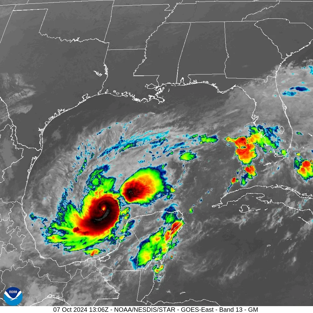
image.png


https://cdn.star.nesdis.noaa.gov/GOES16/ABI/SECTOR/gm/13/1000x1000.jpg
 
Hurricane Milton strengthens into a Category 4. Florida prepares for evacuations and storm surge

BY JEFF MARTIN AND FREIDA FRISARO
Updated 7:26 AM CST, October 7, 2024

FORT LAUDERDALE, Fla. (AP) — Milton rapidly strengthened into a Category 4 hurricane Monday on a path toward Florida population centers including Tampa and Orlando, threatening a dangerous storm surge in Tampa Bay and setting the stage for potential mass evacuations less than two weeks after a catastrophic Hurricane Helene swamped the coastline.
...
Milton is a bit atypical since it formed so far west and is expected to cross the entire southern Gulf, according to Daniel Brown, a hurricane specialist at the center.

“It’s not uncommon to get a hurricane threat in October along the west coast of Florida, but forming all the way in the southwest Gulf and then striking Florida is a little bit more unusual,” Brown said. Most storms that form in October and hit Florida come from the Caribbean, not the southwestern Gulf, he said.
...
Building on lessons learned during Irma and other previous storms, Florida is staging emergency fuel for gas vehicles and charging stations for electric vehicles along evacuation routes, Kevin Guthrie, executive director of the Florida Division of Emergency Management, said Sunday.

“We are preparing ... for the largest evacuation that we have seen, most likely since 2017, Hurricane Irma,” Guthrie said.
...
https://apnews.com/article/hurricane-milton-helene-florida-557c5c512135e0a8661b298e45e17c92​
 
ZCZC MIATCDAT4 ALL
TTAA00 KNHC DDHHMM

Hurricane Milton Discussion Number 10
NWS National Hurricane Center Miami FL AL142024
1000 AM CDT Mon Oct 07 2024


Milton's remarkable rapid intensification is continuing. Satellite
images show a small eye within the very cold central cloud cover,
and the eye is becoming better defined. Data from the Mexican
radar at Sabancuy show a small, closed eye with an intense eyewall
presentation. The Hurricane Hunter aircraft earlier reported a peak
flight-level wind of 146 kt, and dropsonde data show that the
pressure has fallen to around 933 mb, which is down about 22 mb in
4 hours. The initial wind speed is set to 135 kt, which is an
80-kt increase in 24 hours (only eclipsed by Wilma 2005 and Felix
2007 in our records).

The hurricane is still moving east-southeastward, now about 8 kt.
Global models continue to insist that Milton will turn eastward
soon as the frontal low pressure area over the northeastern Gulf of
Mexico departs. The new forecast near Mexico is about the same as
the previous one, but is close enough to bring hurricane-force
winds to the northern portion of Yucatan Peninsula. Later, a new
mid-level trough dropping into the northwestern Gulf of Mexico
should then cause Milton to move east-northeastward to northeastward
at a faster forward speed. The latest model fields are a bit left
of the previous runs, and the official NHC track forecast is shifted
to the north. This forecast is close to a consensus of the latest
GFS, ECMWF and regional hurricane models. Note that this track is
closer to the model fields rather than the model trackers which
appear to be too far south.

Milton is likely to become a category 5 hurricane later today
with light shear and very warm waters in its path.
By tomorrow,
its intensity should be dictated by any eyewall replacement
cycles, which will likely cause the system to gradually weaken
but grow larger.
After 36 h, Milton is expected to encounter a
much less favorable environment with strong shear and dry air
entrainment. Therefore, some weakening is anticipated before the
hurricane reaches the Florida Gulf coast. However, the system is
still likely to be a large and powerful hurricane at landfall in
Florida, with life-threatening hazards at the coastline and well
inland. After landfall, Milton should weaken and start extratropical
transition, which should be complete by 96 h.

Key Messages:

1. Damaging hurricane-force winds are expected across portions of
the northern coast of the Yucatan Peninsula. A life-threatening
storm surge with damaging waves is also likely along portions of
the northern coast of the Yucatan Peninsula.

2. There is an increasing risk of life-threatening storm surge and
damaging winds for portions of the west coast of the Florida
Peninsula beginning Tuesday night or early Wednesday.
Storm Surge
and Hurricane Watches are now in effect for portions of the west
coast of the Florida Peninsula and residents in that area should
follow any advice given by local officials and evacuate if told to
do so.

3. Areas of heavy rainfall will impact portions of Florida today
well ahead of Milton, with heavy rainfall more directly related to
the system expected later on Tuesday through Wednesday night. This
rainfall will bring the risk of considerable flash, urban, and
areal flooding, along with the potential for moderate to major
river flooding.


FORECAST POSITIONS AND MAX WINDS

INIT 07/1500Z 21.7N 91.7W 135 KT 155 MPH
12H 08/0000Z 21.5N 90.4W 145 KT 165 MPH
24H 08/1200Z 22.2N 88.3W 140 KT 160 MPH
36H 09/0000Z 23.6N 86.4W 135 KT 155 MPH
48H 09/1200Z 25.5N 84.7W 125 KT 145 MPH
60H 10/0000Z 27.7N 82.8W 110 KT 125 MPH

72H 10/1200Z 29.2N 80.1W 80 KT 90 MPH
96H 11/1200Z 30.8N 71.0W 55 KT 65 MPH...POST-TROP/EXTRATROP
120H 12/1200Z 31.0N 66.0W 45 KT 50 MPH...POST-TROP/EXTRATROP

$$
Forecaster Blake

NNNN​

https://www.nhc.noaa.gov/text/refresh/MIATCDAT4+shtml/071149.shtml?

-------------------------------------------
image.png


https://www.nhc.noaa.gov/refresh/graphics_at4+shtml/093335.shtml?peakSurge#contents

--------------------------------------------------------------

image.png


https://cdn.star.nesdis.noaa.gov/GOES16/ABI/SECTOR/gm/13/1000x1000.jpg
 
News October 7, 2024

County opens six emergency shelters ahead of Hurricane Milton


Pinellas County is opening six emergency shelters in advance of Hurricane Milton. Effective at noon today, Monday, Oct. 7, the following shelters will be open:
  • Largo High School (general population and pet friendly), 410 Missouri Ave. N., Largo
  • Gibbs High School (general population and pet friendly), 850 34[SUP]th[/SUP] St. S. St. Petersburg
  • Palm Harbor University High School (general population and pet friendly),1900 Omaha St, Palm Harbor
  • Palm Harbor University High School Bldg. 19 (special needs), 1900 Omaha St, Palm Harbor
  • Dunedin Highland Middle School (special needs), 70 Patricia Ave., Dunedin
  • Oak Grove Middle School (special needs), 1370 S. Belcher Road, Clearwater
Mandatory evacuations ordered for special needs residents

The County has issued mandatory evacuation orders for special needs and electrical dependent residents in zones A, B and C, effective at noon today. The County recommends that special needs residents in evacuation zones D and E also evacuate due to the risk of extended power and water outages.

Bus transportation will begin at noon for special needs residents who pre-registered with the County. Special needs residents who did not pre-register can call the County Information Center Call (727) 464-4333. Residents who are deaf or hard of hearing can contact the CIC through online chat at bit.ly/PinellasChat.

Additional evacuation orders are anticipated. At present, the County is encouraging residents in evacuation zones A, B, C and all mobile home residents to evacuate to a strong building on high ground. Depending on where Milton makes landfall, storm surge could impact all three evacuation zones. High winds pose a very serious threat to mobile homes, no matter where they are located.

Residents need not evacuate hundreds of miles. They are encouraged to stay with family or friends outside of an evacuation zone or take advantage of our emergency shelters. If you leave Pinellas County, be prepared to not be able to get back onto the peninsula for days or possibly longer if the storm compromises the bridges and other routes.

State of Local Emergency extended

The Board of County Commissioners extended its State of Local Emergency for seven days and authorized County Administrator Barry A. Burton authority to issue additional extensions. The declaration gives Burton the authority to quickly approve expenditures and issue special orders to ensure public safety and designates Sheriff Bob Gualtieri as the chief law enforcement officer for the County.

Latest storm/incident developments
  • Pinellas County is in the path of Hurricane Milton, a dangerous hurricane that is expected to make landfall Wednesday on the central-west coast of Florida. A Hurricane Watch, Storm Surge Watch and Flood Watch are in effect for Pinellas. Life-threatening storm surge of 8 to 12 feet, hurricane force winds and localized flooding are possible.
  • Pinellas County is encouraging residents and visitors in evacuation zones A, B and C to evacuate to a safe structure on higher ground. Mandatory evacuation orders may be issued today or tomorrow.
  • Mandatory evacuation orders are in effect for long-term care facilities, assisted living facilities and hospitals in evacuation zones A, B and C.
Pinellas County response/action
  • The Pinellas County Solid Waste Disposal Facility is open 24/7 to receive storm debris from anyone. Enter through the 34[SUP]th[/SUP] Street gate if you have storm debris,
  • Pinellas County is working with state and municipal partners and contractors to clear as much Hurricane Helene sand and debris as possible. Sunset Beach and Pass-a-Grille have been cleared of sand.
  • County self-serve sandbag sites are open today until 5 p.m. at John Chesnut Sr. Park and Walsingham Park, while supplies last.
  • The Pinellas County Offices, including Clerk’s Office, Property Appraiser and Tax Collector, are closed Monday through Wednesday. The Supervisor of Elections Office is open today for voter registration. Many employees are working in various capacity on storm response.
  • The County Information Center (CIC) is open 24/7 for preparedness questions. Call (727) 464-4333. Residents who are deaf or hard of hearing can contact the CIC via online chat at bit.ly/PinellasChat
Advice & Information for Residents
  • Take photos of the interior or exterior of your home now and after Hurricane Milton so that FEMA and your property insurance company can determine the damage differential.
  • If you are in an evacuation zone, put everything of importance to you (documents, photos, heirlooms) in a plastic case and take it with you.
  • Refill prescriptions now in case pharmacies are temporarily unavailable. Under a state of emergency, Floridians are permitted to receive early prescription refills.
  • Stay informed: 
  • Move vehicles in surge- and flood-vulnerable areas to higher ground. This is especially true for electric vehicles. Anything with a lithium-ion battery, including golf carts, bikes and scooters can erupt in flames after contact with flood water.
  • Check your Evacuation Zone one of three ways.
  • Call (727) 464-3800 from a landline
    Make your plan: 
    • Purchase necessary items to complete your emergency kit, include everyone in your family including your pet(s). 
    • Know if you can shelter in place or if you may have to evacuate. Know what you will need, where you will go, and how long it will take.  
https://pinellas.gov/news/county-opens-six-emergency-shelters-ahead-of-hurricane-milton/
 
Hurricane Milton Tropical Cyclone Update
NWS National Hurricane Center Miami FL AL142024
1055 AM CDT Mon Oct 07 2024

...MILTON RAPIDLY INTENSIFIES INTO A CATEGORY 5 HURRICANE...

Data from an Air Force Reserve Hurricane Hunter aircraft indicate
that Milton has strengthened to a category 5 hurricane.
The
maximum sustained winds are estimated to be 160 mph (250 km/h) with
higher gusts
. Data from the aircraft also indicate that the
minimum pressure has fallen to 925 mb (27.31 inches).


SUMMARY OF 1055 AM CDT...1555 UTC...INFORMATION
-----------------------------------------------
LOCATION...21.7N 91.6W
ABOUT 125 MI...200 KM W OF PROGRESO MEXICO
ABOUT 735 MI...1175 KM SW OF TAMPA FLORIDA
MAXIMUM SUSTAINED WINDS...160 MPH...250 KM/H
PRESENT MOVEMENT...ESE OR 110 DEGREES AT 9 MPH...15 KM/H
MINIMUM CENTRAL PRESSURE...925 MB...27.31 INCHES

https://www.nhc.noaa.gov/text/refresh/MIATCUAT4+shtml/071553.shtml?
 
A small on the ground report from the Orlando area:

1) It has been raining pre-storm...light rain but the ground is saturated.
2) There was a mob scene at a sandbag distribution I went to. Police were stationed. Did not see any fighting but people were not polite.
3) D batteries flew off the shelf as soon as an employee brought out a new box.
4) A lot of traffic on the roads.
5) There were so many people at Lowe's that it looked like they were having a free giveaway. (Lance's comment)

more later....
 
Emotional John Morales updates on Hurricane Milton as Cat. 5: 'I apologize, this is just horrific'

 
​NWS Tampa Bay
@NWSTampaBay

10/07/24 11am Major Hurricane Milton Update
⚠️Now a Category 5 Hurricane
⚠️If the storm stays on the current track, it will be the worst storm to impact the Tampa area in over 100 years.
⚠️Please evacuate if told to do so.
⚠️Complete all prep before tomorrow night. #flwx


image.png
image.png
image.png
image.png


9:56 AM · Oct 7, 2024​​
 
268
WTNT34 KNHC 071735
TCPAT4

BULLETIN
Hurricane Milton Intermediate Advisory Number 10A
NWS National Hurricane Center Miami FL AL142024
100 PM CDT Mon Oct 07 2024


...MILTON EXPLOSIVELY INTENSIFIES WITH 175-MPH WINDS...
...RESIDENTS IN FLORIDA ARE URGED TO FOLLOW THE ADVICE OF LOCAL
OFFICIALS...


SUMMARY OF 100 PM CDT...1800 UTC...INFORMATION
----------------------------------------------
LOCATION...21.7N 91.3W
ABOUT 105 MI...170 KM WNW OF PROGRESO MEXICO
ABOUT 700 MI...1130 KM SW OF TAMPA FLORIDA

MAXIMUM SUSTAINED WINDS...175 MPH...280 KM/H
PRESENT MOVEMENT...E OR 100 DEGREES AT 9 MPH...15 KM/H
MINIMUM CENTRAL PRESSURE...911 MB...26.90 INCHES
...
https://www.nhc.noaa.gov/text/refresh/MIATCPAT4+shtml/071735.shtml?

-------------------------------------------------

image.png - Click image for larger version  Name:	image.png Views:	1 Size:	1.27 MB ID:	998179


https://cdn.star.nesdis.noaa.gov/GOES16/ABI/SECTOR/gm/13/1000x1000.jpg


Know Your Zone, Know Your Home

​...
Instructions to Know Your Zone, Know Your Home
  • Click Know Your Zone Map (Please note, the Division is continuously updating and making improvements to this website. If you are prompted to log in or are unable to access the map, please try again at a later time.)
  • Type in your address
  • Know Your Zone - Find if your address is in one of the colored evacuation zones (these are flood zones)
​... https://www.floridadisaster.org/Know
 
[TABLE="cellpadding: 0, cellspacing: 2"]
[TR]
[TD]Hurricane Milton RSS Feed icon[/TD]
[TD="align: right"]Satellite | Buoys | Grids | Storm Archive[/TD]
[/TR]
[TR]
[TD="colspan: 2"] [TABLE="border: 0, cellpadding: 0, cellspacing: 5"]
[TR]
[TD="colspan: 8"]...HURRICANE AND STORM SURGE WARNINGS ISSUED FOR PORTIONS OF THE FLORIDA WEST COAST... ...MILTON POSES AN EXTREMELY SERIOUS THREAT TO FLORIDA AND RESIDENTS ARE URGED TO FOLLOW THE ORDERS OF LOCAL OFFICIALS...

4:00 PM CDT Mon Oct 7
Location: 21.8°N 90.8°W
Moving: E at 10 mph
Min pressure: 905 mb
Max sustained: 180 mph

BULLETIN
Hurricane Milton Advisory Number 11
NWS National Hurricane Center Miami FL AL142024
400 PM CDT Mon Oct 07 2024​

-snip-
WATCHES AND WARNINGS
--------------------
CHANGES WITH THIS ADVISORY:

A Storm Surge Warning has been issued for the west coast of Florida
from Flamingo northward to the Suwannee River, including Charlotte
Harbor and Tampa Bay.

A Hurricane Warning has been issued for the west coast of Florida
from Bonita Beach northward to the mouth of the Suwannee River,
including Tampa Bay.

A Tropical Storm Warning has been issued for the west coast of
Florida south of Bonita Beach to Flamingo, including Lake
Okeechobee, and north of the mouth of the Suwannee River northward
and westward to Indian Pass. A Tropical Storm Warning has also been
issued for all of the Florida Keys, including the Dry Tortugas and
Florida Bay.

A Storm Surge Watch has been issued for the U.S. east coast from
Sebastian Inlet Florida to Edisto Beach South Carolina, including
the St. Johns River.

A Hurricane Watch has been issued along the east coast of the
Florida Peninsula from the St. Lucie/Indian River County Line
northward to the mouth of the St. Marys River.

A Tropical Storm Watch has been issued along the east coast of the
Florida Peninsula south of the St. Lucie/Indian River County Line
southward to Flamingo. A Tropical Storm Watch has also been issued
along the coast of Georgia and South Carolina from north of the
mouth of the St. Marys River to South Santee River, South Carolina.​
-snip-

DISCUSSION AND OUTLOOK
----------------------
At 400 PM CDT (2100 UTC), the eye of Hurricane Milton was located
near latitude 21.8 North, longitude 90.8 West. Milton is moving
toward the east near 10 mph (17 km/h). This general motion is
expected through tonight followed by a turn toward the east-
northeast and northeast on Tuesday and Wednesday. On the forecast
track, the center of Milton is forecast to move near or just north
of the Yucatan Peninsula tonight and Tuesday, then cross the
eastern Gulf of Mexico and approach the west coast of the Florida
Peninsula on Wednesday.

Satellite data indicate that the maximum sustained winds have
increased to near 180 mph (285 km/h) with higher gusts. Milton is a
potentially catastrophic category 5 hurricane on the Saffir-Simpson
Hurricane Wind Scale. While fluctuations in intensity are
expected, Milton is forecast to remain an extremely dangerous
hurricane through landfall in Florida.

Hurricane-force winds extend outward up to 30 miles (45 km) from the
center and tropical-storm-force winds extend outward up to 80 miles
(130 km).

The estimated minimum central pressure is 905 mb (26.73 inches).​


HAZARDS AFFECTING LAND
----------------------
Key Messages for Milton can be found in the Tropical Cyclone
Discussion under AWIPS header MIATCDAT4 and WMO header WTNT44 KNHC
and on the web at hurricanes.gov/text/MIATCDAT4.shtml

STORM SURGE: A storm surge will raise water levels by as much as 4
to 6 feet above ground level along the northern coast of the
Yucatan Peninsula in areas of onshore winds. Near the coast, the
surge will be accompanied by large and destructive waves.

The combination of a dangerous storm surge and the tide will cause
normally dry areas near the coast to be flooded by rising waters
moving inland from the shoreline. The water could reach the
following heights above ground somewhere in the indicated areas if
the peak surge occurs at the time of high tide...

Anclote River, FL to Englewood, FL...10-15 ft
Tampa Bay...10-15 ft
Englewood, FL to Bonita Beach, FL...6-10 ft
Charlotte Harbor...6-10 ft
Yankeetown, FL to Anclote River, FL...5-10 ft

Bonita Beach, FL to Chokoloskee, FL...4-7 ft
Suwannee River, FL to Yankeetown, FL...3-5 ft
Chokoloskee, FL to Flamingo, FL...3-5 ft
Flagler/Volusia County Line, FL to Altamaha Sound, GA...3-5 ft
Sebastian Inlet, FL to Flagler/Volusia County Line, FL...2-4 ft
Altamaha Sound, GA to Edisto Beach, SC...2-4 ft
Dry Tortugas...2-4 ft
St. Johns River...2-4 ft


continued: https://www.nhc.noaa.gov/text/refresh/MIATCPAT4+shtml/072057.shtml[/TD]
[/TR]
[/TABLE]
[/TD]
[/TR]
[/TABLE]
 
I received the following message on my phone at 5:09 EDT:

National Weather Service:

A HURRICANE WARNING is in
effect for this area
for dangerous
and damaging
winds. This
warning is issued
up to 36 hours
before hazardous
conditions begin.
Urgently complete
efforts to protect
life and property.
Have food, water,
cash, fuel, and
medications for 3+
days. FOLLOW
INSTRUCTIONS FROM
LOCAL OFFICIALS.
 
[Jacksonville is Duval County]
From Florida Disaster


As of 5 p.m. ET, Hurricane Milton is located about 675 miles southwest of Tampa, Florida with maximum sustained winds of 180 mph. Milton is forecast to move near or just north of the Yucatan Peninsula today and Tuesday, then cross the eastern Gulf of Mexico and approach the west coast of Florida by Wednesday.

Hurricane Warning: Charlotte, Citrus, DeSoto, Hardee, Hernando, Highlands, Hillsborough, Lake, Lee, Levy, Manatee, Marion, Orange, Osceola, Pasco, Pinellas, Polk, Sarasota, Seminole and Sumter counties.

Hurricane Watches: Brevard, Clay, Collier, Duval, Flagler, Glades, Hendry, Indian River, Nassau, Okeechobee, Putnam, St. Johns and Volusia counties.

https://www.floridadisaster.org/news-media/news/20241007/
 
LIVE COVERAGE
Hurricane Milton live updates: 'Potentially catastrophic' Category 5 storm takes aim at Florida

Updated Oct. 7, 2024, 7:56 PM CDT
By NBC News

What to know
Hurricane Milton has intensified rapidly in the Gulf of Mexico, becoming a "potentially catastrophic" Category 5 storm.
  • The storm is making its way east toward Florida and is expected to make landfall late Wednesday on the state's Gulf Coast.
  • As Florida continues to recover from Hurricane Helene, as many as 15 million people are under flood watches there and 11 million are at risk for tropical tornadoes tomorrow and Wednesday. Mandatory evacuations are underway along areas of the state's west coast.
  • Milton is forecast to reach peak intensity tomorrow morning and then weaken to a strong Category 3 ahead of landfall.
... 1h ago / 7:04 PM CDT

National Hurricane Center website crashed briefly

Evan Bush

The National Hurricane Center's website crashed about 5 p.m. ET today. The website hosts hurricane forecasts, warnings and advisories.

"The NHC site was down for about 15 minutes, but it’s back up now and stable. We’ll have more information to share soon," said Erica Grow Cei, a public affairs specialist for the National Weather Service, a division of the National Oceanic and Atmospheric Administration.

The National Weather Service has experienced network outages and technology troubles during high-impact weather events in the recent past. In April, it experienced outages during an outbreak of tornadoes in the Midwest, according to The Washington Post. ...

https://www.nbcnews.com/news/weather/live-blog/hurricane-milton-live-updates-rcna174253
 
Category 4: Northern Yucatan Peninsula put on major Hurricane Milton watch

October 7, 2024
BY RIVIERA MAYA NEWS

Riviera Maya, Q.R. — As of early Monday morning, Hurricane Milton, now a major category 4 storm, was located less than 240 kilometers west-northwest of Progreso, Yucatan.

update--605x480.jpg

Milton is forecast to pass the top of the Yucatan Peninsula starting later today, creating strong winds, heavy rain and high waves. As a category 4 hurricane, authorities report Milton already has maximum sustained winds of 195 kms/h, gusts of 240 kms/h while moving east-southeast at 13 km/h. ...

https://riviera-maya-news.com/categ...urricane-milton-watch/2024.html?cn-reloaded=1
 
Quintana Roo island evacuations begin as Milton intensifies into a category 5 with 330 km/h gusts

OCTOBER 7, 2024

BY RIVIERA MAYA NEWS
CANCUN, RIVIERA MAYA WEATHER

Holbox, Q.R. — Voluntary evacuations on the island of Holbox have begun after Milton took on category 5 status. Around 2:00 p.m. Cancun time, Milton, which is approximately 170 km west-northwest of Progreso, Yucatan, was reported packing sustained winds of 280 kms/h and gusts of 330 kms/h.​

The evacuation is also part of a slight trajectory change that now has Milton forecast to touch Mexican land as it passes through the Gulf of Mexico. The northwestern tip of Mexico’s Yucatan Peninsula is likely to be hit hardest by Milton as its bands dip over land before veering north again into the Gulf.​ ...

https://riviera-maya-news.com/quint...to-a-category-5-with-330-km-h-gusts/2024.html


Back
Top