• FluTrackers.com Inc. does not provide medical advice. Information on this web site is collected from various internet resources, and the FluTrackers board of directors makes no warranty to the safety, efficacy, correctness or completeness of the information posted on this site by any author or poster. The information collated here is for instructional and/or discussion purposes only and is NOT intended to diagnose or treat any disease, illness, or other medical condition. Every individual reader or poster should seek advice from their personal physician/healthcare practitioner before considering or using any interventions that are discussed on this website. By continuing to access this website you agree to consult your personal physican before using any interventions posted on this website, and you agree to hold harmless FluTrackers.com Inc., the board of directors, the members, and all authors and posters for any effects from use of any medication, supplement, vitamin or other substance, device, intervention, etc. mentioned in posts on this website, or other internet venues referenced in posts on this website.
  • We are not asking for any donations. Do not donate to any entity who says they are raising funds for us.

US - Hurricane Milton - October 5+

Pathfinder

Editor, Senior Moderator
National Hurricane Center@NHC_Atlantic

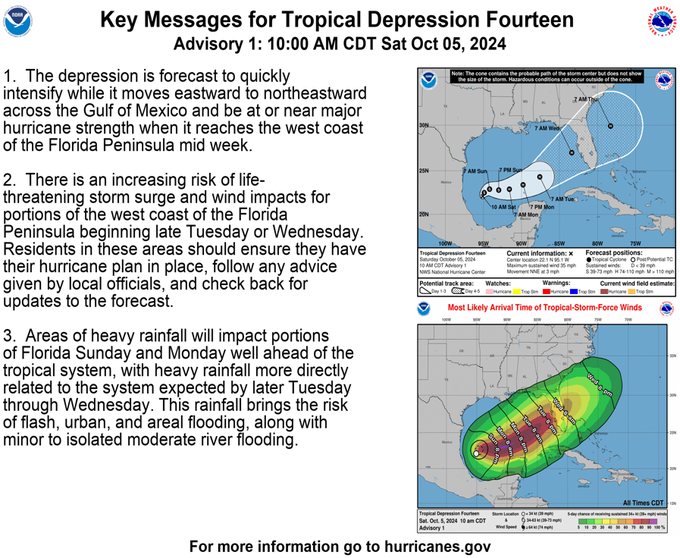
10AM CDT Oct 5: Tropical Depression Fourteen forms in the southwestern Gulf of Mexico. Forecast to strengthen and bring the risk of Life-Threatening impacts to portions of the west coast of Florida next week. Make sure to check back with updates through the weekend and into next week at http://hurricanes.gov​

image.png - Click image for larger version  Name:	image.png Views:	3 Size:	413.5 KB ID:	998099


9:06 AM · Oct 5, 2024

--------------------------------------------

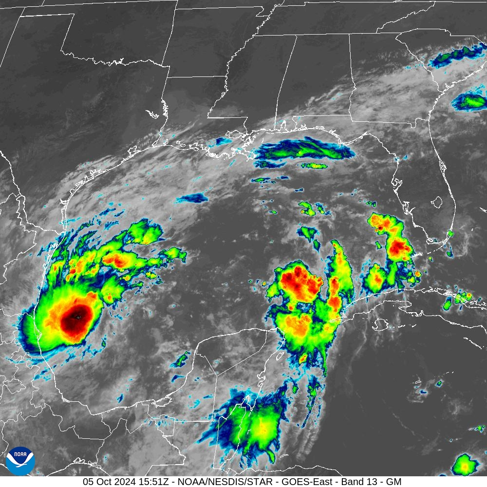
image.png
https://cdn.star.nesdis.noaa.gov/GOES16/ABI/SECTOR/gm/13/1000x1000.jpg
 
As a reminder - no matter what the weather is in Florida, this site will stay online with pertinent information because of our global volunteers.

:flamingo:
 
Tropical Storm Milton Tropical Cyclone Update
NWS National Hurricane Center Miami FL AL142024
1225 PM CDT Sat Oct 05 2024

...TROPICAL DEPRESSION BECOMES TROPICAL STORM MILTON...
...FORECAST TO STRENGTHEN AND BRING THE RISK OF LIFE-THREATENING
IMPACTS TO PORTIONS OF THE WEST COAST OF FLORIDA NEXT WEEK...

Recent satellite wind data indicate that the depression has
strengthened into Tropical Storm Milton. The maximum sustained
winds are estimated to be 40 mph (65 km/h) with higher gusts.


SUMMARY OF 1225 PM CDT...1725 UTC...INFORMATION
---------------------------------------------------
LOCATION...22.3N 95.3W
ABOUT 220 MI...355 KM NNE OF VERACRUZ MEXICO
ABOUT 365 MI...590 KM WNW OF PROGRESO MEXICO
MAXIMUM SUSTAINED WINDS...40 MPH...65 KM/H
PRESENT MOVEMENT...NNE OR 15 DEGREES AT 3 MPH...6 KM/H
MINIMUM CENTRAL PRESSURE...1006 MB...29.71 INCHES

$$
Forecaster Brown/Kelly​
https://www.nhc.noaa.gov/text/refresh/MIATCUAT4+shtml/051725.shtml
 
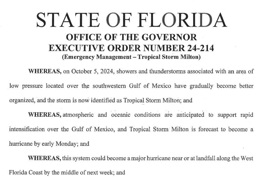
The governor just signed an executive order:

snip

Section 1. Because of the foregoing conditions, which are projected to constitute a major disaster, I declare that a state of emergency exists in Brevard, Broward, Charlotte, Citrus, Collier, DeSoto, Flagler, Glades, Hardee, Hendry, Hernando, Highlands, Hillsborough, Indian River, Lake, Lee, Manatee, Marion, Martin, Miami-Dade, Monroe, Okeechohee, Orange, Osceola, Palm Beach, Pasco, Pinellas, Polk, Putnam, Sarasota, Seminole, St. Johns, St. Lucie, Sumter, and Volusia counties.


https://www.flgov.com/wp-content/uploads/2024/10/EO-24-214.pdf
 
243
WTNT34 KNHC 060530
TCPAT4

BULLETIN
Tropical Storm Milton Intermediate Advisory Number 3A
NWS National Hurricane Center Miami FL AL142024
100 AM CDT Sun Oct 06 2024

...MILTON MOVING SLOWLY BUT EXPECTED TO STRENGTHEN RAPIDLY...
...RISK OF LIFE-THREATENING IMPACTS INCREASING FOR PORTIONS OF THE
FLORIDA WEST COAST...


SUMMARY OF 100 AM CDT...0600 UTC...INFORMATION
----------------------------------------------
LOCATION...23.0N 95.1W
ABOUT 365 MI...585 KM WNW OF PROGRESO MEXICO
ABOUT 855 MI...1375 KM WSW OF TAMPA FLORIDA
MAXIMUM SUSTAINED WINDS...45 MPH...75 KM/H
PRESENT MOVEMENT...NNE OR 25 DEGREES AT 4 MPH...6 KM/H
MINIMUM CENTRAL PRESSURE...1005 MB...29.68 INCHES


WATCHES AND WARNINGS
--------------------
CHANGES WITH THIS ADVISORY:

None.

SUMMARY OF WATCHES AND WARNINGS IN EFFECT:

A Tropical Storm Watch is in effect for...
* Celestun to Cancun

A Tropical Storm Watch means that tropical storm conditions are
possible within the watch area, generally within 48 hours.

Interests in the remainder of the Yucatan peninsula of Mexico, the
Florida Peninsula, the Florida Keys, and the northwestern Bahamas
should monitor the progress of this system.

Hurricane and Storm Surge Watches will likely be required for
portions of Florida late Sunday.

For storm information specific to your area, please monitor
products issued by your national meteorological service.


DISCUSSION AND OUTLOOK
----------------------
At 100 AM CDT (0600 UTC), the center of Tropical Storm Milton was
located near latitude 23.0 North, longitude 95.1 West. Milton is
moving toward the north-northeast near 4 mph (6 km/h). An eastward
to east-northeastward motion is forecast during the next couple of
days, followed by a faster northeastward motion. On the forecast
track, Milton is forecast to move across the Gulf of Mexico and
approach the west coast of the Florida Peninsula by midweek.

Maximum sustained winds are near 45 mph (75 km/h) with higher gusts.
Steady to rapid strengthening is forecast during the next few days.
Milton is forecast to become a hurricane tonight, and it could
become a major hurricane while it moves across the central and
eastern Gulf of Mexico.

Tropical-storm-force winds extend outward up to 35 miles (55 km)
from the center.

The estimated minimum central pressure is 1005 mb (29.68 inches).


HAZARDS AFFECTING LAND
----------------------
Key Messages for Tropical Storm Milton can be found in the Tropical
Cyclone Discussion under AWIPS header MIATCDAT4 and WMO header
WTNT44 KNHC and on the web at hurricanes.gov/text/MIATCDAT4.shtml

RAINFALL: Rainfall amounts of 5 to 8 inches, with localized totals
up to 12 inches, are expected across portions of the Florida
Peninsula and the Keys through Wednesday night. This rainfall brings
the risk of flash, urban, and areal flooding, along with minor to
moderate river flooding.

The system may also produce rainfall of 2 to 4 inches across
portions of the northern Yucatan Peninsula and western Cuba.

For a complete depiction of forecast rainfall associated with
Tropical Storm Milton, please see the National Weather
Service Storm Total Rainfall Graphic, available at
hurricanes.gov/graphics_at4.shtml?rainqpf.

WIND: Tropical storm conditions are possible in the Tropical Storm
Watch area in the Yucatan Peninsula Monday night and Tuesday.

SURF: Swells generated by the system will begin to affect the coast
of the southwestern Gulf of Mexico today. These swells are expected
to spread northward and eastward along much of the Gulf Coast by
early next week, and could cause life-threatening surf and rip
current conditions. Please consult products from your local weather
office.


NEXT ADVISORY
-------------
Next complete advisory at 400 AM CDT.

$$
Forecaster Beven


https://www.nhc.noaa.gov/text/refresh/MIATCPAT4+shtml/060530.shtml?

 
Square profile picture
FL Division of Emergency Management

@FLSERT


As we continue to monitor Tropical Storm #Milton, keep your vehicles at least halfway full or halfway charged to ensure you can evacuate the tens of miles needed to a shelter or safer location based on a storm's strength or your risk of flooding. Ensure your disaster plans are in place for any impacts from #Milton & find more info at http://FloridaDisaster.org/Updates.​


----------------------------------------------------------


snip


BULLETIN
Tropical Storm Milton Intermediate Advisory Number 4A
NWS National Hurricane Center Miami FL AL142024
700 AM CDT Sun Oct 06 2024

...NOAA HURRICANE HUNTER AIRCRAFT FINDS A STRONGER MILTON...
...RISK OF LIFE-THREATENING IMPACTS INCREASING FOR PORTIONS OF THE
FLORIDA WEST COAST...


SUMMARY OF 700 AM CDT...1200 UTC...INFORMATION
----------------------------------------------
LOCATION...22.6N 94.9W
ABOUT 345 MI...560 KM WNW OF PROGRESO MEXICO
ABOUT 860 MI...1385 KM WSW OF TAMPA FLORIDA
MAXIMUM SUSTAINED WINDS...60 MPH...95 KM/H
PRESENT MOVEMENT...E OR 90 DEGREES AT 5 MPH...7 KM/H
MINIMUM CENTRAL PRESSURE...991 MB...29.26 INCHES


WATCHES AND WARNINGS
--------------------
CHANGES WITH THIS ADVISORY:

None.​


https://www.nhc.noaa.gov/text/refresh/MIATCPAT4+shtml/061149.shtml?
 
With Milton, Evacuation Is The Better Part Of Valor


AVvXsEg1b5N4Byc1HzsQqM7luAmVo24kyDUxQFaODzVljbnPRTaU0X1nM-psrx5qNzidP8E160OraO3ORruttsf8RNs6yeo-P0oyYPMqSE8Llj3fgapM6KR0W1kKlcMVab8i6qjxMN6ZlZttFHVtQx6Wnuqiw87I4bYUhELuFosLlbhDVXFGjOGKvTAz7g=w400-h320


NOTE: As of this posting, there are no Hurricane watches or warnings for Florida, and no evacuation orders. But both are coming (either later today or early Monday).

#18,342


With the dual caveats that soon-to-be Hurricane Milton is still 80 hours away, and both its forecast track and intensity (CAT 3) at landfall are subject to change, it is difficult as someone born and raised in St. Petersburg not to shudder at the implications of the NHC graphic above.

For Tampa Bay - home to more than 3 million people - this is pretty close to the worst-case scenario, as it would drive a huge storm surge up into the bay.​

A CAT 4 or 5 storm, or a track another 15-20 miles further up the coast would be worse, of course. While a landfall even 30 to 40 miles further south would greatly reduce the storm surge in Tampa bay.

But that would only shift the disaster to other coastal communities who are still reeling from last week's devastation from Hurricane Helene.​

Even tiny shifts in the track can have huge impacts on storm surge and who needs to evacuate. The flood zones for the Tampa Bay area (below) illustrates just how vulnerable this region is.


But the broader threat from Milton extends across much of the state. Because of the enormity of this threat, last night the Governor issued a State of Emergency for 35 counties.

This will, among other things, allow people to get a 30-day emergency supply of Rx meds.


Regardless of where Milton makes landfall, power outages are likely to be extensive and prolonged. Water and sewer services may be offline, roads and bridges may be blocked, flooded, or damaged, and emergency services (EMS, fire, police) may be severely degraded.

Banks, gas stations, grocery stores, pharmacies, doctors, and other essential services may be shuttered for days or weeks. Stores that are able to reopen may not be able to process Credit or Debit cards. And for thousands of families, there may be no home to return to after the storm.

Barring some major shift in the path, I'll be among the millions who will be forced to evacuate on Tuesday, taking only what I can fit in my car. Thankfully, I have a `Disaster Buddy', who will take me and the cat in.

Not everyone is that lucky, and many may end up in emergency shelters for days. Those who live on the barrier islands may not be able to return for weeks.​

The last time a major hurricane made a direct hit on Tampa Bay (1921), its population was 1/10th what it is today, and practically no one lived on the beaches, or the barrier islands. The damage from Helene just last week is the worst we've taken since then.

We've had close calls, of course.​

Hurricane `Easy' in 1950. Hurricane Donna in 1960, Agnes in 1972, and the no name `storm of the century' in March 1993. In 2004 Cat 4 Hurricane Charley was headed directly for Tampa when it unexpectedly veered east into Ft. Myers.

While I'm hoping for a reprieve, I'll be spending the next 2 days preparing to bug-out. I've got my flu shot scheduled for tomorrow morning (they may be hard to get post-Milton), just like I got my COVID shot before Helene.

I'm going to try to get an emergency 30-day supply of my Rx meds (allowed under the State of Emergency), and I'll be staging what I am able take with me (clothes, Rx meds, important papers, Emergency gear, etc.), so I can quickly pack the car on Tuesday.


Evacuation could be a nightmare, since millions may be ordered to leave, there are limited roads and bridges out of the affected areas, and the weather is expected to deteriorate on Monday (heavy rains). I expect it will take hours to drive the 40 miles to my bug-out location.

I'll take my laptop, but I fully expect to be incommunicado for some time. I'll try to get word to Sharon at FluTrackers (who is also in the path), after the storm.​

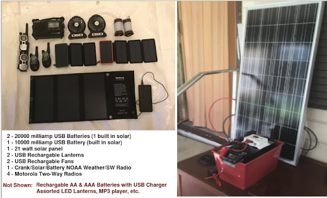
I'll be taking my solar panels, batteries, and accessories (see How Not To Swelter In Place). The one (minor) consolation is that it isn't August, and excessive heat should be less of a problem.


These preps should give us a few basic creature comforts like lights, radios, fans, MP3 players, and charged cell phones. We've got a camp stove, plenty of canned food, and enough propane for several weeks of cooking.

In the end, you can only do what you can do, and hope it turns out to be enough.​

So, if you live anywhere near the west coast of Florida, in a flood-prone region, or live (as I do) in a mobile home away from the coast, now is the time to start planning what you will do tomorrow, and Tuesday, as the storm approaches.

The danger is that too many people will wait too long before deciding whether they will evacuate. Some may be lulled by a forecast track that seems to spare them - but forecasts can change - leaving little time to act.​

While I'll be doing usual hurricane preparedness blogs - and I follow (and highly recommend) Mark Sudduth's Hurricane Track, and Mike's Weather page - your primary source of forecast information should always be the National Hurricane Center in Miami, Florida.
These are the real experts, and the only ones you should rely on to track and forecast the storm.​

If you are on Twitter, you should also follow @FEMA, @NHC_Atlantic, @NHC_Pacific and @ReadyGov, and of course take direction from your local Emergency Management Office.

For more Hurricane resources from NOAA, you'll want to follow these links.
HURRICANE SAFETY
ADDITIONAL RESOURCES
.

https://afludiary.blogspot.com/2024/10/with-milton-evacuation-is-better-part.html
 
583
WTNT44 KNHC 061458
TCDAT4

Tropical Storm Milton Discussion Number 5
NWS National Hurricane Center Miami FL AL142024
1000 AM CDT Sun Oct 06 2024


Satellite and aircraft data indicate that Milton is strengthening.
A large burst of convection is occurring in the northern semicircle
of the storm, with lots of expanding outflow. The last fix from the
NOAA Hurricane Hunter aircraft showed a pressure down to 991 mb
with maximum 500m low-level winds of about 65 kt. These winds
reduce down to the surface to about 55 kt, and this value will be
the initial intensity.

The fixes from the aircraft indicate that Milton is south of the
previously anticipated and has been moving east-southeastward or
105/5 kt. Milton is forecast to move a little south of due east
today in westerly flow from a shortwave trough over the northern
Gulf of Mexico. The storm should then turn northeastward and
accelerate on Tuesday and Wednesday toward the Florida Peninsula.
As a result of this re-positioning and initial motion, there's been
a southward change to most of the guidance this morning. The new
NHC forecast is adjusted south of the previous one, especially early
on, and further southward adjustments could be required if the
guidance trend continues. The Mexican government has issued a
Tropical Storm Warning for the north coast of the Yucatan Peninsula
as a result of the forecast change. It should be noted that the
average NHC track error at day 3 is around 100 miles, and users
should not focus on the exact track.

The NOAA Hurricane Hunter crew reported that an eyewall has formed
on the last center fix, suggesting that this system is ready to
intensify quickly.
Given the track over the very deep warm waters
of the Gulf of Mexico and little shear for the next couple of days,
rapid intensification is explicitly forecast, and the new NHC
prediction could still be conservative over the central Gulf of
Mexico.
The biggest question actually seems to be the intensity as
Milton approaches Florida, with much of the guidance showing a
notable increase in shear. While some weakening is anticipated,
the shear could help transition Milton to be a large hurricane at
landfall, with impacts spread out over a big area. Regardless of
the details, there is increasing confidence that a powerful
hurricane with life-threatening hazards will be affecting portions
of the Florida west coast around the middle of this week. Residents
there should closely monitor this system and listen to local
officials.


Key Messages:

1. Milton is forecast to quickly intensify while it moves eastward
to northeastward across the Gulf of Mexico and be a major hurricane
when it reaches the west coast of the Florida Peninsula mid week.

Users are reminded to not focus on the details of the forecast as
there remains significant uncertainty in the eventual track and
intensity of Milton.

2. While it is too soon to specify the exact magnitude and location
of the greatest impacts, there is an increasing risk of
life-threatening storm surge and damaging winds for portions of the
west coast of the Florida Peninsula beginning Tuesday night or early
Wednesday
. Storm Surge and Hurricane Watches could be issued later
today or tonight.
Residents in the Florida Peninsula should follow
any advice given by local officials and check back for updates to
the forecast.

3. Areas of heavy rainfall will impact portions of Florida today
and Monday well ahead of Milton, with heavy rainfall more directly
related to the system expected later on Tuesday through Wednesday
night. This rainfall will bring the risk of flash, urban, and areal
flooding, along with the potential of moderate to major river
flooding.

4. Tropical storm conditions are expected beginning Monday across
portions of the northern Yucatan Peninsula of Mexico where a
Tropical Storm Warning is in effect.


FORECAST POSITIONS AND MAX WINDS

INIT 06/1500Z 22.4N 94.4W 55 KT 65 MPH
12H 07/0000Z 22.2N 93.7W 65 KT 75 MPH
24H 07/1200Z 22.2N 92.0W 85 KT 100 MPH
36H 08/0000Z 22.5N 90.0W 100 KT 115 MPH
48H 08/1200Z 23.5N 88.0W 110 KT 125 MPH
60H 09/0000Z 24.7N 86.0W 110 KT 125 MPH
72H 09/1200Z 26.5N 84.0W 105 KT 120 MPH

96H 10/1200Z 29.0N 79.0W 75 KT 85 MPH
120H 11/1200Z 31.0N 72.0W 55 KT 65 MPH...POST-TROP/EXTRATROP

$$
Forecaster Blake​

https://www.nhc.noaa.gov/text/refresh/MIATCDAT4+shtml/061458.shtml

-----------------------------------------------
image.png

https://www.nhc.noaa.gov/refresh/graphics_at4+shtml/145937.shtml?key_messages#contents

-----------------------------------------------

image.png


https://cdn.star.nesdis.noaa.gov/GOES16/ABI/SECTOR/gm/GEOCOLOR/1000x1000.jpg
 
...TROPICAL STORM WARNING ISSUED FOR THE NORTH COAST OF YUCATAN... ...RISK OF LIFE-THREATENING IMPACTS INCREASING FOR PORTIONS OF THE FLORIDA WEST COAST... [TABLE="border: 0, cellpadding: 0, cellspacing: 5"]
[TR]
[TD="colspan: 8"]
[/TD]
[/TR]
[TR]
[TD="width: 22%"]10:00 AM CDT Sun Oct 6
Location: 22.4°N 94.4°W
Moving: ESE at 6 mph
Min pressure: 991 mb
Max sustained: 65 mph[/TD]
[/TR]
[/TABLE]

BULLETIN
Tropical Storm Milton Advisory Number 5...Corrected
NWS National Hurricane Center Miami FL AL142024
1000 AM CDT Sun Oct 06 2024

Corrected for Motion description in the outlook section


DISCUSSION AND OUTLOOK
----------------------
At 1000 AM CDT (1500 UTC), the center of Tropical Storm Milton was
located near latitude 22.4 North, longitude 94.4 West. Milton is
moving toward the east-southeast near 6 mph (9 km/h), and this
general motion is expected today. An eastward to east-northeastward
motion is forecast on Monday, followed by a faster northeastward
motion on Tuesday and Wednesday.
On the forecast track, Milton is
forecast to move north of the Yucatan Peninsula and to move across
the Gulf of Mexico and approach the west coast of the Florida
Peninsula by midweek.

Maximum sustained winds have increased to near 65 mph (100 km/h)
with higher gusts. Milton is forecast to rapidly intensify during
the next couple of days and become a hurricane later today and a
major hurricane late Monday.


Tropical-storm-force winds extend outward up to 60 miles (95 km)
from the center.

The estimated minimum central pressure is 991 mb (29.27 inches)
based on NOAA dropsonde data.

In Discussion:
excerpt:
Milton is forecast to move a little south of due east
today in westerly flow from a shortwave trough over the northern
Gulf of Mexico. The storm should then turn northeastward and
accelerate on Tuesday and Wednesday toward the Florida Peninsula.
As a result of this re-positioning and initial motion, there's been
a southward change to most of the guidance this morning. The new
NHC forecast is adjusted south of the previous one, especially early
on, and further southward adjustments could be required if the
guidance trend continues.​


https://www.nhc.noaa.gov/text/refresh/MIATCPAT4+shtml/061518.shtml
 
Orlando area:

I went to a local pharmacy and the pharmacist told me it has been very busy today. There was someone getting cash out of the inside atm.

Traffic was also busy - like a workday.

The Publix parking lot was packed and looked like the day before Thanksgiving.


Seems people have got the message.
 
The storm has been looking like it will move along the Interstate 4 corridor - that is Tampa area in the west, thru Orlando, and ending at Daytona Beach on the east side of the state. The population of the I-4 corridor is about 8 million.

snip

"The Tampa Bay region combined with the I-4 Corridor is home to almost half of Florida’s population. With more than 400 distribution centers, the I-4 Corridor is fueling demand for everything from retail and e-commerce goods, food & beverage, to energy products, and construction & building materials."

https://www.porttb.com/i-4-corridor-growth
 
Hurricane Milton​
4:00 PM CDT Sun Oct 6

SUMMARY OF 400 PM CDT...2100 UTC...INFORMATION
----------------------------------------------
LOCATION...22.4N 93.8W
ABOUT 275 MI...440 KM WNW OF PROGRESO MEXICO
ABOUT 805 MI...1295 KM WSW OF TAMPA FLORIDA
MAXIMUM SUSTAINED WINDS...85 MPH...140 KM/H
PRESENT MOVEMENT...E OR 100 DEGREES AT 7 MPH...11 KM/H
MINIMUM CENTRAL PRESSURE...983 MB...29.03 INCHES


Maximum sustained winds have increased to near 85 mph (140 km/h)
with higher gusts. Milton is forecast to rapidly intensify during
the next couple of days and become a major hurricane on Monday.

Hurricane-force winds extend outward up to 25 miles (35 km) from the
center and tropical-storm-force winds extend outward up to 80 miles
(130 km).

The estimated minimum central pressure is 983 mb (29.03 inches).

Discussion:
While it is too soon to specify the exact magnitude and location
of the greatest impacts, there is an increasing risk of life-
threatening storm surge and damaging winds for portions of the west
coast of the Florida Peninsula beginning early Wednesday and Storm
Surge and Hurricane Watches will likely be issued tonight or early
Monday.​

https://www.nhc.noaa.gov/text/refresh/MIATCPAT4+shtml/DDHHMM.shtml


000
WTNT44 KNHC 062053
TCDAT4

Hurricane Milton Discussion Number 6
NWS National Hurricane Center Miami FL AL142024
400 PM CDT Sun Oct 06 2024

Milton is rapidly intensifying.
Satellite images indicate very
deep convection in the eyewall and hints of an eye starting to
appear. The last fix from the aircraft showed that the
central pressure was down to 985 mb, about 3 mb less than 80
minutes prior, and winds supporting 70 kt at the surface. Since
that time, satellite images continue to show further organization,
and the initial wind speed is set to 75 kt.

Milton is moving just south of due east at about 6 kt. This
equatorward motion has been more than expected probably due to a
stronger low/ mid-level frontal low over the northeastern Gulf of
Mexico. The frontal feature is forecast to weaken while it moves
across Florida and gradually lose its influence on Milton. This
evolution should allow the hurricane to turn eastward on Monday and
then accelerate to the northeast on Tuesday and Wednesday toward the
Florida Peninsula ahead of a trough moving offshore of Texas. The
NHC forecast is a bit south of the previous one through 48 hours,
following the trend of the guidance at that time, and the government
of Mexico has issued a Hurricane Watch for a portion of the northern
coast of Yucatan. Later on, the guidance is similar to, or slightly
north of the last cycle, and very little change is made to the
forecast near Florida. It should be noted that the average NHC track
error at day 3 is around 100 miles, and users should not focus on
the exact track.


The intensity forecast appears straightforward at first, with rapid
intensification likely while the small hurricane remains within
light shear and over very deep warm waters. Intensity guidance is
about as bullish as I've seen in this part of the basin, with
almost everything showing a peak intensity of category 4 or 5 in
the southern Gulf of Mexico in a day or two. The NHC forecast is
raised from the previous one and lies near the intensity consensus
model and still could be too low.
Later on, vertical wind shear is
forecast to markedly increase as Milton approaches Florida, and
some weakening is anticipated. However, the regional hurricane
models are showing the system growing even if it weakens, and we are
expecting Milton to be a large hurricane at landfall, with very
dangerous impacts spread out over a big area. There is increasing
confidence that a powerful hurricane with life- threatening hazards
will be affecting portions of the Florida west coast around the
middle of this week. Residents there should closely monitor this
system and listen to local officials.


Key Messages:

1. Milton is forecast to be a major hurricane when it reaches the
west coast of the Florida Peninsula midweek.
Users are reminded to
not focus on the details of the forecast as there remains
significant uncertainty in the eventual track and intensity of
Milton.


2. While it is too soon to specify the exact magnitude and location
of the greatest impacts, there is an increasing risk of life-
threatening storm surge and damaging winds for portions of the west
coast of the Florida Peninsula beginning early Wednesday and Storm
Surge and Hurricane Watches will likely be issued tonight or early
Monday. Residents in the Florida Peninsula should follow any advice
given by local officials and monitor updates to the forecast.

3. Areas of heavy rainfall will impact portions of Florida through
Monday well ahead of Milton, with heavy rainfall more directly
related to Milton expected on Tuesday through Wednesday night. This
rainfall will bring the risk of considerable flash, urban, and areal
flooding, along with the potential for moderate to major river
flooding.

4. Tropical storm conditions are expected with hurricane conditions
possible beginning Monday across portions of the northern Yucatan
Peninsula of Mexico where a Tropical Storm Warning and Hurricane
Watch are in effect.


FORECAST POSITIONS AND MAX WINDS

INIT 06/2100Z 22.4N 93.8W 75 KT 85 MPH
12H 07/0600Z 22.2N 92.6W 90 KT 105 MPH
24H 07/1800Z 22.2N 90.9W 110 KT 125 MPH
36H 08/0600Z 22.6N 89.0W 120 KT 140 MPH
48H 08/1800Z 23.6N 86.9W 125 KT 145 MPH
60H 09/0600Z 25.2N 85.1W 120 KT 140 MPH

72H 09/1800Z 27.0N 83.1W 105 KT 120 MPH
96H 10/1800Z 29.8N 77.5W 65 KT 75 MPH...POST-TROP/EXTRATROP
120H 11/1800Z 31.4N 68.8W 55 KT 65 MPH...POST-TROP/EXTRATROP

$$
Forecaster Blake​

https://www.nhc.noaa.gov/text/refresh/MIATCDAT4+shtml/062053.shtml

-------------------------------------------------------

image.png


https://www.nhc.noaa.gov/refresh/graphics_at4+shtml/212936.shtml?key_messages#contents

------------------------------------------------------------
image.png


https://cdn.star.nesdis.noaa.gov/GOES16/ABI/SECTOR/gm/13/1000x1000.jpg
 
BULLETIN
Hurricane Milton Intermediate Advisory Number 6A
NWS National Hurricane Center Miami FL AL142024
700 PM CDT Sun Oct 06 2024

...MILTON EXPECTED TO BECOME A MAJOR HURRICANE IN THE NEXT DAY OR
SO...


SUMMARY OF 700 PM CDT...0000 UTC...INFORMATION
----------------------------------------------
LOCATION...22.5N 93.4W
ABOUT 250 MI...405 KM WNW OF PROGRESO MEXICO
ABOUT 780 MI...1255 KM WSW OF TAMPA FLORIDA
MAXIMUM SUSTAINED WINDS...85 MPH...140 KM/H
PRESENT MOVEMENT...E OR 100 DEGREES AT 7 MPH...11 KM/H
MINIMUM CENTRAL PRESSURE...981 MB...28.97 INCHES​


DISCUSSION AND OUTLOOK
----------------------
At 700 PM CDT (0000 UTC), the center of Hurricane Milton was
located by Air Force and NOAA Hurricane Hunters near latitude 22.5
North, longitude 93.4 West. Milton is moving toward the east near
7 mph (11 km/h), and this general motion is expected tonight. An
eastward to east-northeastward motion is forecast on Monday,
followed by a faster northeastward motion on Tuesday and
Wednesday. On the forecast track, Milton is forecast to move just
north of the Yucatan Peninsula and across the southern Gulf of
Mexico Monday and Tuesday and approach the west coast of the
Florida Peninsula by Wednesday.

Maximum sustained winds are near 85 mph (140 km/h) with higher
gusts. Milton is forecast to intensify rapidly during the next
couple of days and become a major hurricane on Monday
.

Hurricane-force winds extend outward up to 25 miles (35 km) from
the center and tropical-storm-force winds extend outward up to 80
miles (130 km).

The minimum central pressure estimated from Hurricane Hunter
aircraft observations is 981 mb (28.97 inches).

https://www.nhc.noaa.gov/text/refresh/MIATCPAT4+shtml/062355.shtml

 
BULLETIN
Hurricane Milton Advisory Number 8
NWS National Hurricane Center Miami FL AL142024
400 AM CDT Mon Oct 07 2024

...MILTON STRENGTHENING OVER THE SOUTHERN GULF OF MEXICO...
...STORM SURGE AND HURRICANE WATCHES ISSUED FOR PORTIONS OF
FLORIDA...


SUMMARY OF 400 AM CDT...0900 UTC...INFORMATION
----------------------------------------------
LOCATION...22.1N 92.6W
ABOUT 195 MI...310 KM WNW OF PROGRESO MEXICO
ABOUT 750 MI...1210 KM WSW OF TAMPA FLORIDA
MAXIMUM SUSTAINED WINDS...100 MPH...155 KM/H
PRESENT MOVEMENT...ESE OR 105 DEGREES AT 8 MPH...13 KM/H
MINIMUM CENTRAL PRESSURE...972 MB...28.71 INCHES​


WATCHES AND WARNINGS
--------------------
CHANGES WITH THIS ADVISORY:

The Government of Mexico has issued a Hurricane Warning for the
coast of the Yucatan Peninsula from Celestun to Rio Lagartos.

A Hurricane Watch is now in effect for the Gulf coast of Florida
from Chokoloskee northward to the mouth of the Suwanee River,
including Tampa Bay, and the Dry Tortugas.

A Storm Surge Watch has been issued for the Florida Gulf Coast from
Flamingo northward to the Suwannee River, including Charlotte Harbor
and Tampa Bay.

A Tropical Storm Watch is now in effect for the Florida Gulf Coast
west of the Suwannee River to Indian Pass, and south of Chokoloskee
to Flamingo. A Tropical Storm Watch has also been issued for the
Lower, Middle, and Upper Florida Keys, including Florida Bay

SUMMARY OF WATCHES AND WARNINGS IN EFFECT:

A Hurricane Warning is in effect for...
* Coast of the Yucatan Peninsula of Mexico from Celestun to Rio
Lagartos

A Hurricane Watch is in effect for...
* Coast of the Yucatan Peninsula of Mexico from Rio Lagartos to
Cabo Catoche
* Florida Gulf coast from Chokoloskee to the mouth of the Suwanee
River, including Tampa Bay
* Dry Tortugas

A Storm Surge Watch is in effect for...
* Florida Gulf coast from Flamingo northward to the Suwannee River,
including Charlotte Harbor and Tampa Bay

A Tropical Storm Warning is in effect for...
* Coast of the Yucatan Peninsula of Mexico from Rio Lagartos to
Cancun


​continued: https://www.nhc.noaa.gov/text/refresh/MIATCPAT4+shtml/070857.shtml?
 
[TABLE="border: 0, cellpadding: 0, cellspacing: 5"]
[TR]
[TD="colspan: 8"]
[/TD]
[/TR]
[TR]
[TD="width: 22%"]6:00 AM CDT Mon Oct 7
Location: 21.9°N 92.4°W
Moving: ESE at 8 mph
Min pressure: 954 mb
Max sustained: 120 mph


Hurricane Milton Tropical Cyclone Update
NWS National Hurricane Center Miami FL AL142024
600 AM CDT Mon Oct 07 2024

...NOAA HURRICANE HUNTERS FIND MILTON A MAJOR HURRICANE...

Data from a NOAA Hurricane Hunter aicraft indicate that Milton has
strengthened to a major hurricane. The maximum sustained winds are
estimated to be 120 mph (195 km/h). Milton is a category three
hurricane
on the Saffir-Simpson Hurricane Wind Scale. Data from
the aircraft also indicate that the minimum pressure has fallen to
954 mb (28.17 inches).

A special advisory will be issued by 7 AM CDT (1200 UTC) to reflect
this change and update the forecast.


SUMMARY OF 600 AM CDT...1100 UTC...INFORMATION
----------------------------------------------
LOCATION...21.9N 92.4W
ABOUT 180 MI...285 KM WNW OF PROGRESO MEXICO
ABOUT 750 MI...1210 KM WSW OF TAMPA FLORIDA
MAXIMUM SUSTAINED WINDS...120 MPH...195 KM/H
PRESENT MOVEMENT...ESE OR 105 DEGREES AT 8 MPH...13 KM/H
MINIMUM CENTRAL PRESSURE...954 MB...28.17 INCHES


https://www.nhc.noaa.gov/text/refresh/MIATCUAT4+shtml/071100.shtml[/TD]
[/TR]
[/TABLE]
 
Hurricane Watches Raised For Most of Florida's West Coast


AVvXsEiiuNy-dkirnB3gHuOPGKU3xzfw4zei4b1yFXhgbu3RHX2K133IpQDZY7i_Lksls3-o2kMR713jTXSwOf5atciRunmrWDmSjvepNKF_pcCCzVHCDaAABFO60FEkCaBAtGWdtJnQ2x98r7h9ibWCBdegGk6iE-zNEIU7Xef4ntlqM1GuulirI5EaOA=w400-h327


#18,343

In their 5 am advisory, the NHC posted Hurricane & Tropical storm watches for the entire west coast of Florida in anticipation of the arrival of Hurricane Milton late Wednesday afternoon. As the graphic above shows, Hurricane conditions are expected well inland.

Milton, currently a CAT 3 storm still in the far western Gulf of Mexico, is expected to grow to a CAT 4 or 5 storm over the next 36 hours, but is forecast to weaken somewhat before landfall. Probably to a CAT 3 or (hopefully) lower.​

But even if that happens, it will be pushing a massive wall of water ahead of it towards the coast. Record surge tides are expected to the right of where the eye makes landfall, but exactly where that will be is still unknown.


Because of this uncertainty, a lot of people are going to be forced to evacuate low-lying coastal areas, even though some may be spared the worst. While surge is the biggest risk to life and property, the effects of Milton are likely to be widespread and long-lasting.

Extended power outages are inevitable. Millions are likely to find themselves without power, water, internet, or sewer for days or even weeks. Others may find their homes flooded, or damaged from high winds, and unlivable without extensive repairs.​

As far as what people can expect inland, away from the coast the National Weather Service has released this local product:


For the purple colored regions they forecast:

Threat Level - Potential for wind greater than 110 mph

Potential Impacts Include:​
*Structural damage to sturdy buildings, some with complete roof and wall failures. Complete destruction of mobile homes. Damage greatly accentuated by large airborne projectiles. Locations may be uninhabitable for weeks or months.
*Numerous large trees snapped or uprooted along with fences and roadway signs blown over.​
*Many roads impassable from large debris, and more within urban or heavily wooded places. Many bridges, causeways, and access routes impassable.
*Widespread power and communications outages.

For the red colored area:
Threat Level - Potential for wind 74 to 110 mph

Potential Impacts Include:​
*Considerable roof damage to sturdy buildings, with some having window, door, and garage door failures leading to structural damage. Mobile homes severely damaged, with some destroyed. Damage accentuated by airborne projectiles. Locations may be uninhabitable for weeks.
*Many large trees snapped or uprooted along with fences and roadway signs blown over.​
*Some roads impassable from large debris, and more within urban or heavily wooded places. Several bridges, causeways, and access routes impassable.​
*Large areas with power and communications outages.

While not everyone in these warned areas will see these extreme conditions, everyone in Milton's path needs to prepare as if they could.

Since I live in a mobile home in the red area, I'll be evacuating to a friend's house (also in the red area). Luckily, I'm well inland and don't have to worry about flood damage to my home, but the wind is another matter.​

As I've written often, most disasters boil down to unscheduled camping. Living without power, internet, heat or A/C, running water (and sometimes even flushing toilets) . . . sometimes for weeks. Most of my preps are built upon that premise.

While the 12 hours or so that Milton pounds Florida will be traumatic and damaging, the biggest dangers from a hurricane often come in the days and weeksafter the storm has passed, due to injuries or illness that occur during the `recovery' period.​

Some of the many dangers include:
One of the most common, and dangerous threats comes from floodwaters which may linger for days, or even weeks following the storm. Waters that may contain toxic chemicals, dangerous viruses and bacteria, and hidden hazards like snakes, rats, and broken glass, sharp metal, or even live electrical wires.The CDC maintains a web page on the dangers of Flood Waters or Standing Waters and in 2022 we looked at Florida: Uptick Of Vibrio Infections Following Hurricane Ian.

And lastly, the physical and mental impact of a major disaster should not be underestimated. Many people are going to lose their homes, businesses, and their savings due to this storm.​

In March of 2009, in a study led by Dr. Anand Irimpen (Associate Professor of clinical medicine at Tulane), it was disclosed that residents of New Orleans saw a 300% increase in heart attacks in the first 2 years after hurricane Katrina.

A follow up, published in 2014 (see Tulane University: Post-Katrina Heart Attack Rates - Revisited),once again found the impact of Katrina on cardiac health remained pronounced.​

In the wake of Hurricane Katrina, a study funded by the National Institute of Mental Health, which surveyed 1,043 survivors, found:
  • More than 11% were diagnosed with a serious mental illness following the storm. This compares to just over 6% before the hurricane.
  • 9.9% had mild-moderate mental illness, compared to 9.7% before Katrina.
  • They estimated 200,000 people facing serious mental problems, such as PTSS (Post Traumatic Stress Syndrome) and depression, in the three states most affected.
In 2014, in Post-Disaster Stress Cardiomyopathy: A Broken-Hearted Malady,we looked at a rare condition known as Takotsubo cardiomyopathy – or stress induced cardiomyopathy which is often linked to extreme grief or stress, as might be experienced following a disaster.

Also known as broken heart syndrome, this acute ballooning of the heart ventricles is a well-recognized cause of acute heart failure and dangerous cardiac arrhythmia's.​

While often hidden from view, the psychological impact of a disaster can be enormous and ongoing. In 2011, in Post Disaster Stress & Suicide Rates, we looked at the impacts of disaster-related PTSD (Post Traumatic Stress Disorder).

A small reminder that in the wake of a disaster not all wounds bleed, not all fractures show up on an X-ray, and that the best treatment can't always found inside your first aid kit.

https://afludiary.blogspot.com/2024/10/hurricane-watches-raised-for-most-of.html
 
Back
Top