• FluTrackers.com Inc. does not provide medical advice. Information on this web site is collected from various internet resources, and the FluTrackers board of directors makes no warranty to the safety, efficacy, correctness or completeness of the information posted on this site by any author or poster. The information collated here is for instructional and/or discussion purposes only and is NOT intended to diagnose or treat any disease, illness, or other medical condition. Every individual reader or poster should seek advice from their personal physician/healthcare practitioner before considering or using any interventions that are discussed on this website. By continuing to access this website you agree to consult your personal physican before using any interventions posted on this website, and you agree to hold harmless FluTrackers.com Inc., the board of directors, the members, and all authors and posters for any effects from use of any medication, supplement, vitamin or other substance, device, intervention, etc. mentioned in posts on this website, or other internet venues referenced in posts on this website.
  • We are not asking for any donations. Do not donate to any entity who says they are raising funds for us.

US - Hurricane Helene updates: death toll >200, damage across the Southeast - September 26+ ,2024

Pathfinder

Editor, Senior Moderator
Tropical Storm Helene Public Advisory
[TABLE="border: 0, cellpadding: 0, cellspacing: 0"]
[TR]
[TD]Home Public Adv Fcst Adv Discussion Wind Probs Graphics Archive

U.S. Watch/Warning

Español: Aviso Publico Discusión

[/TD]
[/TR]
[/TABLE]
062
WTNT34 KNHC 241458
TCPAT4

BULLETIN
Tropical Storm Helene Advisory Number 5
NWS National Hurricane Center Miami FL AL092024
1100 AM EDT Tue Sep 24 2024

...TROPICAL STORM HELENE FORMS OVER THE NORTHWESTERN CARIBBEAN
SEA...
...HURRICANE AND STORM SURGE WATCHES REMAIN IN EFFECT FOR PORTIONS
OF THE FLORIDA GULF COAST...


SUMMARY OF 1100 AM EDT...1500 UTC...INFORMATION
-----------------------------------------------
LOCATION...19.5N 84.3W
ABOUT 180 MI...295 KM ESE OF COZUMEL MEXICO
ABOUT 170 MI...275 KM SSE OF THE WESTERN TIP OF CUBA
MAXIMUM SUSTAINED WINDS...45 MPH...75 KM/H
PRESENT MOVEMENT...NW OR 310 DEGREES AT 12 MPH...19 KM/H
MINIMUM CENTRAL PRESSURE...1000 MB...29.53 INCHES


WATCHES AND WARNINGS
--------------------
CHANGES WITH THIS ADVISORY:

A Tropical Storm Warning has been issued for the Lower Florida Keys
west of the Seven Mile Bridge and for the Dry Tortugas.

A Tropical Storm Watch has been issued for the Middle Florida Keys
from the Seven Mile Bridge to the Channel 5 Bridge.

SUMMARY OF WATCHES AND WARNINGS IN EFFECT:

A Storm Surge Watch is in effect for...
* Indian Pass southward to Flamingo
* Tampa Bay
* Charlotte Harbor

A Hurricane Watch is in effect for...
* Cabo Catoche to Tulum, Mexico
* Cuban province of Pinar del Rio
* Englewood to Indian Pass
* Tampa Bay

A Tropical Storm Warning is in effect for...
* Dry Tortugas
* Lower Florida Keys west of the Seven Mile Bridge
* Grand Cayman
* Rio Lagartos to Tulum, Mexico
* Cuban provinces of Artemisa, Pinar del Rio, and the Isle of Youth

A Tropical Storm Watch is in effect for...
* Middle Florida Keys from the Seven Mile Bridge to the Channel 5
Bridge
* Flamingo to south of Englewood
* West of Indian Pass to Walton Bay County line

A Storm Surge Watch means there is a possibility of life-
threatening inundation, from rising water moving inland from the
coastline, in the indicated locations during the next 48 hours.
For a depiction of areas at risk, please see the National Weather
Service Storm Surge Watch/Warning Graphic, available at
hurricanes.gov.

A Tropical Storm Warning means that tropical storm conditions are
expected somewhere within the warning area within the next 36 hours.

A Hurricane Watch means that hurricane conditions are possible
within the watch area. A watch is typically issued 48 hours
before the anticipated first occurrence of tropical-storm-force
winds, conditions that make outside preparations difficult or
dangerous.

A Tropical Storm Watch means that tropical storm conditions are
possible within the watch area, generally within 48 hours.

Wind and storm surge warnings will likely be required for the
U.S. later today.

For storm information specific to your area in the United
States, including possible inland watches and warnings, please
monitor products issued by your local National Weather Service
forecast office. For storm information specific to your area
outside of the United States, please monitor products issued by
your national meteorological service.


DISCUSSION AND OUTLOOK
----------------------
At 1100 AM EDT (1500 UTC), the center of Tropical Storm Helene was
located near latitude 19.5 North, longitude 84.3 West. Helene is
moving toward the northwest near 12 mph (19 km/h), and this
general motion is expected to continue through early Wednesday. A
northward to north-northeastward motion at a faster forward speed
is expected on Wednesday and Thursday. On the forecast track, the
center of Helene will move across the far northwestern Caribbean
Sea through tonight, and then move across the eastern Gulf of
Mexico Wednesday and Thursday, potentially reaching the Gulf coast
of Florida late Thursday.

Data from an Air Force Reserve Hurricane Hunter aircraft indicate
that the system has acquired a well-defined center of circulation,
and maximum sustained winds have increased to near 45 mph (75 km/h)
with higher gusts. Additional strengthening is forecast, and
Helene is expected to become a hurricane on Wednesday. Continued
strengthening is anticipated after that time, and Helene could
become a major hurricane on Thursday.

Tropical-storm-force winds extend outward up to 140 miles (220 km)
to the east of the center.

Data from the Hurricane Hunter aircraft indicate that the minimum
central pressure is 1000 mb (29.53 inches).


HAZARDS AFFECTING LAND
----------------------
Key Messages for Helene can be found in the Tropical Cyclone
Discussion under AWIPS header MIATCDAT4 and WMO header WTNT44 KNHC
and on the web at hurricanes.gov/text/MIATCDAT4.shtml

RAINFALL: Helene is expected to produce total rain accumulations of
4 to 8 inches over western Cuba and the Cayman Islands with isolated
totals around 12 inches. Over the eastern Yucatan Peninsula, 4 to 6
inches of rain are expected with isolated totals over 8 inches. This
rainfall brings a risk of considerable flooding.

Over the Southeastern U.S., Helene is expected to produce total rain
accumulations of 4 to 8 inches with isolated totals around 12
inches. This rainfall will likely result in areas of considerable
flash and urban flooding, with minor to moderate river flooding
likely, and isolated major river flooding possible.

For a complete depiction of forecast rainfall associated with
Helene, please see the National Weather Service Storm Total Rainfall
Graphic, available at hurricanes.gov/graphics_at4.shtml?rainqpf and
the Flash Flood Risk graphic at
hurricanes.gov/graphics_at4.shtml?ero.

STORM SURGE: The combination of a dangerous storm surge and the
tide will cause normally dry areas near the coast to be flooded by
rising waters moving inland from the shoreline. The water could
reach the following heights above ground somewhere in the indicated
areas if the peak surge occurs at the time of high tide...

Ochlockonee River, FL to Chassahowitzka, FL...10-15 ft
Chassahowitzka, FL to Anclote River, FL...6-10 ft
Indian Pass, FL to Ochlockonee River, FL...5-10 ft
Anclote River, FL to Middle of Longboat Key, FL...5-8 ft
Tampa Bay...5-8 ft
Middle of Longboat Key, FL to Englewood, FL...4-7 ft
Englewood, FL to Bonita Beach, FL...3-5 ft
Charlotte Harbor...3-5 ft

For a complete depiction of areas at risk of storm surge inundation,
please see the National Weather Service Peak Storm Surge Graphic,
available at hurricanes.gov/graphics_at4.shtml?peakSurge.

Storm surge could raise water levels by as much as 2 to 4 feet above
normal tide levels in areas of onshore winds along the southern
coast of Pinar del Rio, Cuba, including the Isle of Youth.

Storm surge could raise water levels by as much as 2 to 4 feet above
ground level in areas of onshore winds within the warning area along
the east coast of the Yucatan Peninsula.

WIND: Hurricane conditions are possible within the watch areas in
Cuba and Mexico by early Wednesday. Hurricane conditions are
possible within the U.S. watch areas Wednesday night and early
Thursday. Tropical storm conditions are expected in the warning
areas in the Cayman Islands, Cuba, and Mexico today. Tropical
storm conditions are expected in the warning area in the Lower
Florida Keys beginning on Wednesday, and are possible in the watch
area in the Middle Florida Keys beginning late Wednesday.

SURF: Swells generated by Helene will affect the southern coast
of Cuba and the Yucatan Peninsula of Mexico during the next couple
of days. Swells will spread northward toward the west coast of
Florida and the northeastern Gulf Coast on Wednesday and Thursday.
These swells are likely to cause life-threatening surf and rip
current conditions. Please consult products from your local weather
office.


NEXT ADVISORY
-------------
Next intermediate advisory at 200 PM EDT.
Next complete advisory at 500 PM EDT.

$$
Forecaster Berg​

https://www.nhc.noaa.gov/text/refresh/MIATCPAT4+shtml/241458.shtml

-------------------------------------
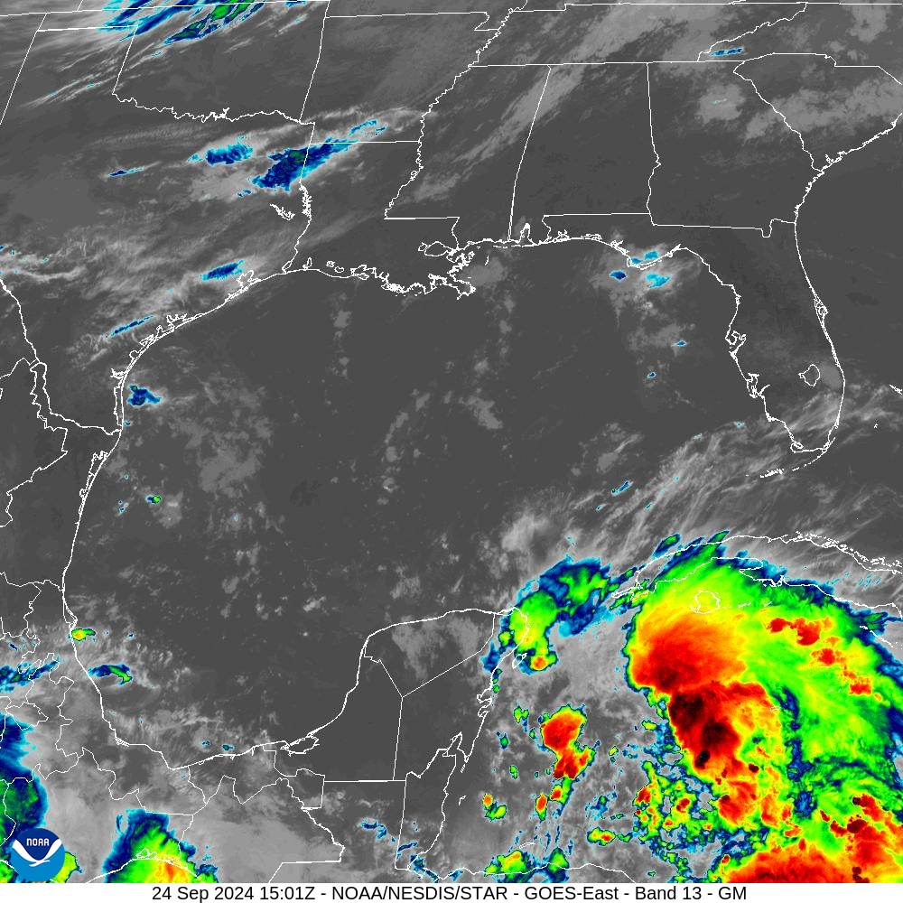
image.png
https://cdn.star.nesdis.noaa.gov/GOES16/ABI/SECTOR/gm/13/1000x1000.jpg
 
Ron DeSantis
@GovRonDeSantis


Tropical Storm Helene, now formed, is projected to intensify.

As always, Florida will prepare for the worst and hope for the best. We already have nearly 18,000 linemen staged (and more en route), and are ready with search and rescue and roadway clearing crews.

Stay tuned to local and state emergency recommendations and alerts. Get preparations in place now for the storm and heed evacuation directives, if issued, from local officials.

image.png


9:32 AM · Sep 24, 2024​​
 
Michael Lowry@MichaelRLowry

These points from the @NWSNHC discussion on #Helene can't be emphasized enough. This is destined to be a BIG hurricane. Don't be fooled by recent storms. The forecast extent of tropical storm winds is nearly twice the size of Debby and Idalia, with possibly a stronger core.​

image.png - Click image for larger version  Name:	image.png Views:	1 Size:	200.8 KB ID:	997411


9:11 AM · Sep 24, 2024
 
Helene's explosive forecast one of the 'most aggressive' in hurricane history

Dinah Voyles Pulver
USA TODAY
PublIshed 4:55 p.m. ET Sept. 24, 2024

The forecast for Helene to transition from a potential tropical cyclone to a Category 3 hurricane appears to be the fastest progression ever predicted for a depression by the National Hurricane Center.

“They had never forecast a major hurricane within 60 hours for a disturbance below tropical storm level,” said Sam Lillo, a meteorologist and software engineer for DTN Weather, based on a computer analysis of the center’s historical forecast data. "The entire forecast is also basically faster than has ever been seen for 36 hours and 48 hours from a tropical depression.”

The National Hurricane Center didn't have that stat at the ready Tuesday as they were focused on operational forecasting for Helene, now a tropical storm, but "it's either the highest or one of the highest," said John Cangialosi, one of the center's senior hurricane specialists.

The forecast for a "70-knot increase in 72 hours on Monday was among the most aggressive forecasts" for a potential tropical cyclone, Cangialosi said.

"It's an aggressive forecast for good reason," he said. "We're trying to get ahead of the possible rapid intensification before it gets to Florida."
...
https://www.usatoday.com/story/news...icane-helene-forecast-aggressive/75365007007/
 
Tropical Storm Helene Discussion Number 8...Corrected
NWS National Hurricane Center Miami FL AL092024
400 AM CDT Wed Sep 25 2024


Corrected Helen to Helene

Helene has strengthened some since the last advisory. Reports from
an Air Force Reserve Hurricane Hunter aircraft indicate that
the central pressure has fallen to 985 mb, and that the maximum
850 mb flight-level were 58 kt in the northeastern quadrant. A
dropsonde in the northwest quadrant reported a splash wind of 59
kt, but the boundary-layer average suggested sustained winds closer
to 45 kt. Based on these data and increasing satellite intensity
estimates, the initial intensity is increased to 55 kt. Despite
the increased intensity, the aircraft data, along with radar data
from Mexico and Cuba, show that Helene has not yet formed a
well-defined inner core.

The initial motion is 325/8 kt. Helene should turn northward
during the next 12 h or so on the western side of a mid-level
ridge, and then it should accelerate northward to
north-northeastward as it become embedded in the deep-layer flow
between the ridge and a mid-latitude trough/developing cut-off low
over the Mississippi valley. This motion should bring the center
near the northeastern coast of the Yucatan Peninsula this morning,
then across the eastern Gulf of Mexico tonight and Thursday to a
landfall along the northeast coast of the Gulf of Mexico late
Thursday or Thursday night.
After landfall, Helene should curve
cyclonically around the cut-off low until it dissipates. The new
forecast track is little changed from the previous track.

Over the next couple of days, Helene will be moving through an
environment of low vertical wind shear, ample environmental
moisture, and over waters of high oceanic heat content. All
guidance forecasts steady to rapid intensification, including the
RI indices associated with the SHIPS model. The latest forecast
calls for a 105 kt intensity by 36 h, and this could be
conservative as some of the guidance is stronger.
After landfall,
Helene is forecast to weaken and become post-tropical as it gets
tangled up in the baroclinic system over the southeastern United
States.

Helene's wind field is predicted to grow to a very large size in the
NHC forecast. Therefore storm surge, wind, and rainfall impacts
will likely extend well away from the center and outside the
forecast cone, particularly on the east side. In addition, the fast
forward speed while Helene crosses the coast will likely result in
farther inland penetration of strong winds over parts of the
southeastern United States after landfall.


KEY MESSAGES:

1. Helene is forecast to intensify and be near hurricane strength
when it passes near the northeastern coast of the Yucatan
Peninsula during the next several hours, where a Hurricane Warning
is in effect.

2. Helene is expected to rapidly intensify and grow in size over the
eastern Gulf of Mexico. There is a danger of life-threatening storm
surge along the entire west coast of the Florida Peninsula and
Florida Big Bend. The highest inundation levels are expected along
the coast of the Florida Big Bend. Residents in those areas should
follow advice given by local officials and evacuate if told to do
so.


3. Damaging hurricane-force winds are expected along portions of
coast of the Florida Big Bend, where a Hurricane Warning is now in
effect. Preparations to protect life and property should be
completed by early Thursday since tropical storm conditions are
expected to begin within this area on Thursday.


4. Tropical Storm Helene will bring heavy rain to portions of the
western Caribbean with potentially significant flooding across
western Cuba and the northeastern Yucatan Peninsula. Considerable
and potentially life-threatening flash and urban flooding is
expected across portions of Florida, the Southeast, the Southern
Appalachians, and the Tennessee Valley beginning today through
Friday.
This includes the risk of landslides across the southern
Appalachians. Widespread minor to moderate river flooding is likely,
and isolated major river flooding is possible.


FORECAST POSITIONS AND MAX WINDS

INIT 25/0900Z 20.7N 86.2W 55 KT 65 MPH
12H 25/1800Z 21.9N 86.5W 70 KT 80 MPH
24H 26/0600Z 24.1N 86.2W 90 KT 105 MPH
36H 26/1800Z 27.4N 85.0W 105 KT 120 MPH
48H 27/0600Z 32.0N 84.2W 65 KT 75 MPH...INLAND
60H 27/1800Z 35.9N 85.4W 30 KT 35 MPH...POST-TROP/INLAND
72H 28/0600Z 37.0N 87.8W 20 KT 25 MPH...POST-TROP/INLAND
96H 29/0600Z 36.5N 88.0W 20 KT 25 MPH...POST-TROP/INLAND
120H 30/0600Z...DISSIPATED

$$​

https://www.nhc.noaa.gov/text/refresh/MIATCDAT4+shtml/250913.shtml?

---------------------------------------------------------------

image.png - Click image for larger version  Name:	image.png Views:	2 Size:	1.74 MB ID:	997433


https://cdn.star.nesdis.noaa.gov/GOES16/ABI/SECTOR/gm/GEOCOLOR/1000x1000.jpg

--------------------------------------

image.png


https://www.nhc.noaa.gov/refresh/graphics_at4+shtml/094338.shtml?cone#contents​
 
Tropical Storm Helene

Press Release Updates


ICYMI: Governor Ron DeSantis Issues Updates on State Preparedness Efforts Ahead of Helene 9/24/24 Executive Orders


Executive Order 24-208

Executive Order 24-209

State Assistance Information Line


Residents in need of information can call: 1-800-342-3557 for resources before and after Helene.

There are English, Spanish and Creole speakers available to answer questions.


Make a Plan


While living in and visiting Florida offers many benefits and advantages, it is important to keep in mind severe weather hazards and potential threats. Every family and business should have predefined emergency plans and always keep an emergency supply kit ready and stocked.

Each Florida county has a designated emergency management program, and residents, businesses, and visitors should also visit their county's emergency management for the most up-to-date and locally significant information.
County Emergency Management Information

County Emergency Management Websites

[TD="width: 860"] Alachua | Baker | Bay | Bradford | Brevard | Broward [/TD]

[TD="width: 860"] Calhoun | Charlotte | Citrus | Clay | Collier | Columbia [/TD]

[TD="width: 860"] DeSoto | Dixie | Duval | Escambia | Flagler | Franklin [/TD]

[TD="width: 860"] Gadsden | Gilchrist | Glades | Gulf [/TD]

[TD="width: 860"] Hamilton | Hardee | Hendry | Hernando | Highlands | Hillsborough | Holmes [/TD]

[TD="width: 860"] Indian River | Jackson | Jefferson [/TD]

[TD="width: 860"] Lafayette | Lake | Lee | Leon | Levy | Liberty [/TD]

[TD="width: 860"] Madison | Manatee | Marion | Martin | Miami-Dade | Monroe [/TD]

[TD="width: 860"] Nassau | Okaloosa | Okeechobee | Orange | Osceola [/TD]

[TD="width: 860"] Palm Beach | Pasco | Pinellas | Polk | Putnam [/TD]

[TD="width: 860"] Santa Rosa | Sarasota | Seminole | St. Johns | St. Lucie | Sumter | Suwannee [/TD]

[TD="width: 860"] Taylor | Union | Volusia | Wakulla | Walton | Washington [/TD]
County Emergency Managers


Click the link or view the map below for County EM Managers with contact information
Evacuation Information


All Florida coastal counties and counties are susceptible to storm surge and most have designated evacuation zones. Use the mapping tool below to search by address and determine if you are in a designated evacuation zone.

For assistance in finding shelters near you and transportation support CALL: (800) 729-3413

Evacuation Zones - to determine if you are in a designated evacuation zone

Evacuation Orders - View Florida county evacuation orders

Read More About Evacuation Zones - learn more about designated evacuation zones, which counties have them and which don't, how flood zones are factored into evacuations, and evacuation orders

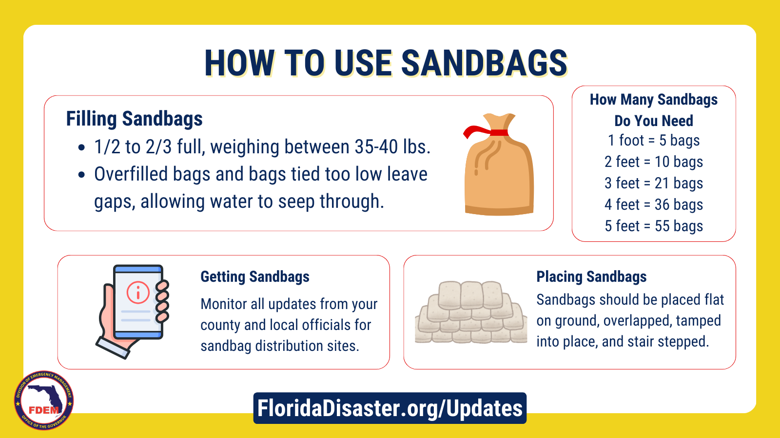
Sandbag Usage


How To Fill A Sandbag:

Fill sandbags 1/2 to 2/3 full, tie at top so bag will lay flat when put in place. A properly filled sand bag should weigh between 35-40 lbs.

Overfilled bags and bags tied too low leave gaps in sandbag levee allowing water to seep through. An overfilled sandbag can weigh 70 - 75 lbs.

TIP: Always use gloves to protect your hands during the filling operation. After handling treated bags, avoid contact with your eyes and mouth. Dress appropriately and layer clothing. Safety goggles should be used on dry and windy days.

Overfilled bags and bags tied too low leave gaps in sandbag levee allowing water to seep through. An overfilled sandbag can weigh 70–75 lbs.

How To Place Sandbags:

Sandbags should be placed flat on ground, overlapped, tamped into place, and stair stepped.

How Many Bags Do You Need? [TABLE="border: 0, cellpadding: 0, cellspacing: 0"]
[TR]
[TD] [TABLE="border: 0, cellpadding: 0, cellspacing: 1"]
[TR]
[TD]Height in feet[/TD]
[TD]Bags Required[/TD]
[/TR]
[TR]
[TD]1[/TD]
[TD]5[/TD]
[/TR]
[TR]
[TD]2[/TD]
[TD]10[/TD]
[/TR]
[TR]
[TD]3[/TD]
[TD]21[/TD]
[/TR]
[TR]
[TD]4[/TD]
[TD]36[/TD]
[/TR]
[TR]
[TD]5[/TD]
[TD]55[/TD]
[/TR]
[/TABLE]
[/TD]
[/TR]
[/TABLE]
imageko3oj.png


Know Your Zone, Know Your Home


Every year it's important for residents to know if they live an evacuation zone, a low-lying, flood prone area, a mobile home or an unsafe structure during hurricane season. These areas and buildings are most likely to be evacuated and knowing these zones helps Floridians prepare to evacuate and better understand orders from local officials.

This year, it is also very important for residents to know their home. If an evacuation order is not issued for your area and your house is not in an evacuation zone, you may consider sheltering in place. If you shelter in place, it’s important to know your home and its ability to withstand strong winds and heavy rain.

Instructions to Know Your Zone, Know Your Home
  • Click Know Your Zone Map (Please note, the Division is continuously updating and making improvements to this website. If you are prompted to log in or are unable to access the map, please try again at a later time.)
  • Type in your address
  • Know Your Zone - Find if your address is in one of the colored evacuation zones (these are flood zones)
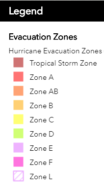
  • If you are in an evacuation zone, listen to evacuation orders from local officials (Typically Zone A is the most vulnerable and the most likely to evacuate first. Zone E is most likely to evacuate last)
  • If an evacuation order is not issued for your area, you may consider sheltering in place. Not all evacuations zones are always ordered.
  • If you shelter in place, it’s important to Know Your Home and its ability to withstand strong winds and heavy rain
Take a look to see where your zone is at Know Your Zone Map. Zone Designations


evacuation_zones.png


Report Price Gouging


Report Price Gouging in Florida

Anyone who suspects price gouging can report it to the Florida Attorney General’s Office by visiting MyFloridaLegal.com or calling 1(866) 9NO-SCAM.
  • Office of the Attorney General Call: 1-866-966-7226

https://www.floridadisaster.org/disaster-updates/storm-updates/
 
Hurricane Helene Discussion Number 9
NWS National Hurricane Center Miami FL AL092024
1000 AM CDT Wed Sep 25 2024


Air Force Reserve and NOAA Hurricane Hunter aircraft have been
investigating Helene, with each plane recently measuring peak
flight-level winds of 81 kt and 78 kt, respectively. Helene has
therefore become a hurricane
with an estimated intensity of 70 kt.
Dropsonde data also indicate that the pressure has fallen to about
979 mb. Radar data from Mexico and Cuba, as well as reconnaissance
reports, indicate that Helene has formed a partial, elliptical
eyewall that is open on the east side.

Helene has turned north-northwestward (330/9 kt) and is expected to
turn northward and north-northeastward later today and tonight,
bringing the center to the coast of the Florida Big Bend Thursday
evening.
After landfall, Helene is expected to interact with a
deep-layer trough over the Lower Mississippi Valley and swing back
to the northwest and stall near the Tennessee Valley late Friday
into the weekend. The track guidance remains tightly clustered,
and the NHC forecast is generally just an update of the previous
prediction. It is still too soon at this point to be overly focused
on an exact landfall location and time, since NHC track forecasts
can be off by an average of 60 nm at the 36-hour forecast time.

Helene is expected to move through/over an environment of
relatively low shear, strong upper-level divergence, and sea
surface temperatures of 29-31 degrees Celsius, all of which should
foster additional strengthening. Rapid Intensification (RI)
indices indicate a high chance of RI during the next 24 hours, and
as a result the NHC intensity forecast shows Helene becoming a
major hurricane by Thursday morning. There is still some
uncertainty on exactly how strong Helene will get, and upward
adjustments to the forecast intensity could be required in
subsequent advisories if Helene rapidly intensifies more than
forecast. Regardless, Helene is forecast to be a large major
hurricane when it reaches the Big Bend coast of Florida
. As a
result, storm surge, wind, and rainfall impacts will likely extend
well away from the center and outside the forecast cone,
particularly on the east side. In addition, the fast forward speed
while Helene crosses the coast will likely result in farther inland
penetration of strong winds over parts of the southeastern United
States after landfall, including strong gusts over higher terrain
of the southern Appalachians.


KEY MESSAGES:

1. Hurricane and tropical storm conditions are expected over
northeastern portions of the Yucatan Peninsula of Mexico today where
Tropical Storm and Hurricane Warnings are in effect. Tropical storm
conditions are occurring over portions of western Cuba within the
Tropical Storm Warning area, and hurricane conditions are possible
today within the Hurricane Watch area.

2. Due to the large size of Helene, there is a danger of
life-threatening storm surge along the entire west coast of the
Florida Peninsula and Florida Big Bend. The highest inundation of
greater than 10 ft is expected along the Florida Big Bend coast.
Residents in those areas should follow advice given by local
officials and evacuate if told to do so.


3. Devastating hurricane-force winds are expected across portions
of northern Florida and southern Georgia where the core of Helene
moves inland. Preparations to protect life and property should be
completed by early Thursday since tropical storm conditions are
expected to begin within these areas on Thursday. Because of
Helene’s expected fast forward speed, damaging and life-threatening
wind gusts, are expected to penetrate well inland over portions of
the southeastern United States, including in the higher terrain of
the southern Appalachians.


4. Helene will bring heavy rain to portions of the western
Caribbean with potentially significant flooding across western Cuba
and the northeastern Yucatan Peninsula into early Thursday.
Considerable and potentially life-threatening flash and urban
flooding is expected across portions of northwestern and northern
Florida, the Southeast, southern Appalachians, and the Upper
Tennessee Valley Wednesday through Friday. This includes the risk of
landslides across the southern Appalachians.
Widespread minor to
moderate river flooding is likely, and isolated major river flooding
is possible.


FORECAST POSITIONS AND MAX WINDS

INIT 25/1500Z 21.6N 86.3W 70 KT 80 MPH
12H 26/0000Z 23.0N 86.4W 85 KT 100 MPH
24H 26/1200Z 25.7N 85.7W 105 KT 120 MPH
36H 27/0000Z 29.7N 84.6W 110 KT 125 MPH
48H 27/1200Z 34.3N 85.0W 50 KT 60 MPH...INLAND
60H 28/0000Z 36.6N 86.9W 30 KT 35 MPH...POST-TROP/INLAND
72H 28/1200Z 36.9N 87.8W 20 KT 25 MPH...POST-TROP/INLAND
96H 29/1200Z 36.6N 87.9W 15 KT 15 MPH...POST-TROP/INLAND
120H 30/1200Z...DISSIPATED

$$
Forecaster Berg​

https://www.nhc.noaa.gov/text/refresh/MIATCDAT4+shtml/251457.shtml?

----------------------------------------
image.png


https://www.nhc.noaa.gov/refresh/graphics_at4+shtml/152934.shtml?key_messages#contents

---------------------------------------------

image.png
https://cdn.star.nesdis.noaa.gov/GOES16/ABI/SECTOR/gm/13/1000x1000.jpg
 
Governor Ron DeSantis Issues Updates on State Preparedness Efforts Ahead of Hurricane Helene

On September 25, 2024, in News Releases, by Staff


TALLAHASSEE, Fla.—Today, Governor Ron DeSantis was joined by Florida Division of Emergency Management (FDEM) Executive Director Kevin Guthrie in Tampa to meet with power and utility linemen staged and ready to respond to power outages caused by Hurricane Helene, and to provide updates on state preparedness efforts before the storm’s landfall.

Following Governor DeSantis’ request, FEMA approved the state’s pre-landfall disaster declaration request. This will provide important resources and assistance from the federal government, including personnel, equipment and supplies, as well as making available funding sources for emergency protective measures. The pre-landfall declaration request is for the 41 Florida counties included in Executive Order 24-208.

Governor DeSantis issued Executive Order 24-209 on September 24, updating EO 24-208 and declaring a state of emergency for 61 counties, which allows for state officials to make critical resources available to communities ahead of any potential storm impacts.

Voluntary and mandatory evacuation orders are in effect in multiple counties statewide. Residents need to evacuate as soon as possible if they are under a mandatory evacuation order. Counties under evacuation orders can be found at FloridaDisaster.org/EvacuationOrders.

Residents in need of assistance finding or going to a shelter in the Big Bend region for Hurricane Helene can call (800) 729-3413. FDEM team members will be conducting callbacks from messages received last night, as well as accepting new calls today, to facilitate shelter coordination. For additional resources and assistance, residents can call the State Assistance Information Line (SAIL) at (800) 342-3557. Assistance is available in English, Spanish and Haitian-Creole.

As of 11AM ET, the storm has strengthened into Hurricane Helene, with maximum sustained winds of 80 mph. Helene is expected to move across the eastern Gulf of Mexico and to the Florida Big Bend coast by Thursday evening. Additional strengthening is forecast, and Helene is expected to be a major hurricane when it reaches landfall.

Watches and warnings in effect include

Hurricane Warning: western Alachua, coastal Citrus, Columbia, Dixie, Franklin, Gadsden, Gilchrist, Gulf, Hamilton, coastal Hernando, Jefferson, Lafayette, Leon, Levy, Liberty, Madison, western Marion, coastal Pasco, Suwannee, Taylor and Wakulla counties

Hurricane Watch: inland Citrus, inland Hernando, coastal Hillsborough, coastal Manatee, inland Pasco, Pinellas, coastal Sarasota

Tropical Storm Warning: central and eastern Alachua, Baker, Bay, Bradford, Brevard, Broward, Calhoun, Charlotte, inland Citrus, Clay, Collier, DeSoto, Duval, Flagler, Glades, Hardee, Hendry, Highlands, inland Hernando, Hillsborough, Holmes, Indian River, Jackson, Lake, Lee, Miami-Dade, Monroe (including Florida Keys and Dry Tortugas), Manatee, central and eastern Marion, Martin, Nassau, Okeechobee, Orange, Osceola, Palm Beach, inland Pasco, Pinellas, Polk, Putnam, Sarasota, Seminole, St. Johns, St. Lucie, Sumter, Union, Volusia, Walton, Washington

Storm Surge Warning: along the entire Florida Big Bend and West Coast through Southwest Florida

Storm Surge Watch: Coastal Bay and Gulf counties along Mexico Beach to Indian Pass

Floridians are encouraged to know their risks from hurricane hazards and prepare for potential impacts from Hurricane Helene. To learn more, residents can visit FloridaDisaster.org/Guide.

Counties have begun their preparation efforts including measures like sandbag stations. For updates on county resources available visit FloridaDisaster.org/Counties for a list of all 67 county emergency management contacts.

State Preparedness Efforts
  • The Florida Division of Emergency Management (FDEM) activated the State Emergency Operations Center to a Level 1 on Tuesday, September 24 and is leading coordination efforts for the State Emergency Response Team.
  • FDEM is hosting twice-daily calls with all 67 counties to identify needs and to ensure the state is prepared to respond quickly and efficiently.
  • Additionally, FDEM is coordinating with state agencies, non-governmental organizations, and private sector partners to facilitate ongoing resource requests for counties, including requests for water, generators and support personnel.
  • Over 800 missions are being facilitated by the State Emergency Response Team to assist counties in their preparation efforts. These missions accomplish vital tasks like prestaging response resources, protecting critical infrastructure facilities like hospitals and utility stations, and coordinating personnel statewide.
  • There are 35,000 shelf-stable meals being staged near the anticipated area of storm impact, ready to deploy for response.
  • Seven Urban search and rescue task forces are ready to deploy to as soon as weather conditions permit.
  • The Florida National Guard (FLNG) has mobilized nearly 3,500 Soldiers and Airmen in preparation for Hurricane Helene, and is able to surge to 5,500, if needed.
  • The FLNG is focused on preparing and staging forces ahead of the storm, assigning areas of responsibility, and placing liaison officers in the projected affected counties.
  • The FLNG is postured to provide logistics support, law enforcement support, route clearance, search and rescue, commodity distribution, flood mitigation, aviation and other support as needed by the state.
  • The Florida State Guard (FSG) has prepared the following:
    • 250+ Soldiers ready to deploy.
    • 10 shallow water vessel boat teams
    • 7 flat-bottom-flood rescue skiffs
    • 2 amphibious rescue vehicles
    • 12 UTV’s
    • 15 Cut and toss crews
    • 7 search and rescue teams
    • 1 UH-60 Blackhawk for daytime aerial assessment and logistics missions
  • The Florida Department of Law Enforcement (FDLE) mutual aid team is at the State Emergency Operations Center coordinating law enforcement missions. FDLE logistics teams are moving and staging assets.
  • FDLE has moved all assets, including aircraft, and is ready to respond for reconnaissance and damage assessments.
  • FDLE members are coordinating with our partners to immediately respond to impacted areas once it is safe.
  • FDLE agents are assigned to all activated county emergency management centers.
  • FDLE has prepared all back-up satellite and communications systems. Portable towers have been staged for emergency communications.
  • FDLE has ten squads of agents ready to respond.
  • The Florida Fish and Wildlife Conservation Commission (FWC) continues to monitor Hurricane Helene’s path and has readied high-water vehicles and all other storm response resources statewide so they may be rapidly deployed to assist Floridians in need in the event of damage or flooding.
  • Contingency plans and pre-storm staging areas based on forecasted landfall locations have been developed and remain flexible based on the storm’s projected path.
  • 53 FWC officers and two support staff are ready to deploy and respond with a variety of specialized equipment as necessary, such as:
    • 6 Airboats
    • 8 Shallow draft boats
    • ATVs/Side-by-sides
    • 54 high-water capable four-wheel drive vehicles
    • 3 aerial surveillance drones
    • 10 high-water capable swamp buggies/Fat Truck/UTVs
    • 3 SOG support trailers
    • 3 BERG self-sustainment container units
    • 3 Hygiene trailers
    • 2 Mobile command units
    • 5 Generators
    • 2 Water trailers
    • 1 Fuel trailer
  • The FWC has identified multiple teams of officers from areas of the state unlikely to be severely affected by the storm to deploy to areas that may be seriously impacted.
    • These teams are mobilizing self-sustainment equipment to establish an effective base of operations immediately following the storm’s passing.
    • These officers and assets are in addition to local FWC officers already assigned to any affected areas. FWC officers have the training, capacity, equipment, and experience to effectively respond to natural disasters.
  • FWC Captive Wildlife Investigators have contacted captive wildlife facilities in the projected path to assist as needed.
  • FWC teams are assembling chainsaws and other necessary equipment for storm debris cleanup mission.
  • The Florida Department of Corrections (FDC) is monitoring the storm and implementing mitigation measures, including:
    • Mobilizing evacuation assets
    • Locating areas of evacuation
    • Pre-staging equipment (including generators) in advance of landfall
    • Established liaisons in our local county and municipal EOCs for storm assistance
    • Suspended inmate visitation statewide until Monday, September 30th
    • Evacuated 22 facilities and relocated 2,553 inmates into hardened housing units, with more on the way
    • Readied 7 maintenance strike teams around the state to respond to potential damage to infrastructure
    • The FDC will be posting updates publicly and in real-time at FDC.myflorida.com/weather-updates
  • The Florida Department of Juvenile Justice (DJJ) offices and have finalized storm preparations to ensure the safety and security of staff and youth.
  • These actions include fueling all vehicles, moving vehicles in low-lying and flood-prone areas to higher ground, testing and ensuring adequate fuel supplies for generators in the event of loss of power, and ensuring food, medicine, and emergency supplies are stocked and ready.
  • The Florida Department of State continues to share on its social media channels various updates about information, resources and assistance available from the Executive Office of the Governor and the Division of Emergency Management.
  • The Florida Department of State, Division of Elections has been monitoring the storm and has been providing updates and information to Supervisors of Elections about potential impacts and resources available to their offices.
  • Over 1,700 Florida Department of Transportation (FDOT) team members are working directly on storm response.
  • 7 Districts, Central Office, and FDOT’s Turnpike Enterprise initiated statewide internal preparedness conference calls beginning Monday, September 23, which continue daily.
  • FDOT Secretary issued FDOT Emergency Order on 9/23/24.
    • FDOT has lifted weight restrictions and is allowing bypass of weigh stations for emergency response vehicles, including utility vehicles staging for rapid response.
  • FDOT Statewide Preparedness Efforts Include:
    • 889 team members working in offices, and EOCs conducting pre-storm preparations.
    • 574 team members working in the field conducting pre-storm preparations.
    • 228 pieces of heavy equipment being used for pre-storm preparations.
    • 176 team members staged for cut and toss operations
    • 90 bridge inspectors staged for deployment
    • 32 team members staged for UAV (drone) deployment
    • 40 large pumps staged
    • 553 generators staged to assist with traffic signal power
    • 4 ITS trailers staged.
    • Road Ranger Service is available 24 hours in FDOT District 2 (Northeast Florida, and in Marion County in District 5 (Central Florida).
      • Road Ranger Service will be available in District 3 (Panhandle) beginning Wednesday, September 25, at 10 p.m.
    • Clearing shoulders in preparation for potential Emergency Should Use (ESU).
    • Currently analyzing flooding vulnerabilities for major roadways and bridges.
    • Inspecting and clearing drainage systems, monitoring flood-prone and currently saturated areas, and pre-positioning pumps as appropriate.
    • Work has been suspended and project sites secured on construction projects with lane closures in the counties listed below that are located on I-10, I-75, Florida Turnpike facilities or major arterials (evacuation routes):
      • Alachua, Baker, Bay, Bradford, Brevard, Calhoun, Charlotte, Citrus, Clay, Collier, Columbia, DeSoto, Dixie, Duval, Escambia, Flagler, Franklin, Gadsden, Gilchrist, Glades, Guld, Hamilton, Hardee, Hendry, Hernando, Highlands, Hillsborough, Holmes, Jackson, Jefferson, Lafayette, Lake, Lee, Leon, Levy, Liberty, Madison, Manatee, Marion, Monroe, Nassau, Okaloosa, Okeechobee, Orange, Osceola, Pasco, Pinellas, Polk, Putnam, Santa Rosa, Sarasota, Seminole, St. Johns, Sumter, Suwannee, Taylor, Union, Volusia, Wakulla, Walton, Washington
  • Securing high mast lighting, maintenance yards, active construction projects, rest areas/welcome centers, service plazas, and weigh stations.
    • Howard Frankland Bridge barges and cranes anticipated to be fully secured by Wednesday, 9/25
    • Sanibel Island Causeway construction barges anticipated to be fully secured by end of day, Tuesday, 9/24.
    • Replenishing fuel reserves, checking generator readiness, and pre-positioning assets as appropriate.
  • Completing repairs on malfunctioning vehicles and equipment in preparation for deployment.
  • Initiated communication with modal partners – seaports, airports, railroads, transit, and spaceports. All partners are currently in monitoring posture.
  • Staging ITS trailers, as well as drone teams and equipment are being prepped and ready to deploy as needed.
  • FDOT encourages drivers to download the FL511 app or visit FL511.com for road/bridge closures and potential detours that may be activated. Remember to always follow the direction of local law enforcement and emergency personnel.
  • Seaports are open and preparing for storm.
    • Port of Key West is closed waterside.
    • Port Tampa Bay is open with restrictions waterside.
    • SeaPort Manatee is open with restrictions waterside.
    • Port St. Pete is open with restrictions waterside.
    • All other Seaports are open and preparing for storm.
  • Airports are open and monitoring the storm.
  • Railroads are open and monitoring the storm.
    • Amtrak
    • September 25th – Train 91 (Southbound Silver Star) New York to Miami via Tampa will bypass Tampa and Lakeland, Florida.
    • September 26th – Train 92 (Northbound Silver Star) Miami to New York via Tampa will bypass Tampa and Lakeland, Florida.
  • Transit agencies are open and monitoring the storm.
    • Transit agencies are monitoring the storm.
    • The following transit providers have made the following schedule modifications:
      • JTA Skyway will not be operating on Thursday.
      • Big Bend Transit will not be operating on Thursday or Friday.
      • Calhoun County Transit will not be operating on Thursday or Friday.
      • Gulf ARC Transit will not be operating on Thursday or Friday.
        JTRANS will not be operating on Thursday or Friday.
      • Liberty County Transit will not be operating on Thursday or Friday. (Emergency and Evacuation only)
      • Wakulla County Transit will not be operating on Thursday or Friday.
    • Spaceport partners are open and monitoring the storm.
      • The Space X flight scheduled for Thursday has been rescheduled for Saturday.
  • The Florida Department of Veterans’ Affairs (FDVA) has alerted the home administrators of its nine State Veterans’ Homes of the approach of the coming storm. They are implementing their hurricane preparation checklists.
  • As a reminder, the VISN 8 Clinical Contact Center is operational 24/7/365 for virtual care and tele-emergency care and support to Veterans enrolled for VA Health Care in Florida. 1-877-741-3400. Visit https://department.va.gov/integrated-service-networks/visn-08 (under highlights), for more information.
  • Volunteer Florida, in coordination with Volunteer Florida Partners and the Florida VOAD, are identifying actions taken, available assets, resource gaps, and staging and service locations.
  • Volunteer Florida continues ongoing coordination with Florida Community Emergency Response Teams.
  • Coordination calls with Volunteer Florida partners are scheduled to begin today
  • Florida Department of Management Services (FDMS) are working to identify potential evacuation shelter sites for special needs and pet friendly evacuees as far east as Lake City and west as Panama City.
Health and Human Services
  • The Agency for Persons with Disabilities (APD) has established Response and pre-landfall communications and protocols with region personnel and facilities teams.
  • APD is hosting calls with regional offices, APD-operated Facilities, Adult Day Training providers, and Group Home providers located within the 61 counties under declared state of emergency (EO 24-209); anticipating unmet needs, communicating up-to-date storm activities, office closures, and ensuring effective reporting.
  • APD is preparing policy documentation for anticipated storm event actions: Providing regional staff with curfew letters for providers in potential counties with issued curfews.
  • APD is identifying team members for post-storm deployment and staffing for potential local distribution centers.
  • In collaboration with the SERT, sister agencies, and partners, APD plans to oversee the necessary Access and Functional Needs activities for this storm.
  • The Florida Department of Health’s (DOH) is deploying over 135 emergency response vehicles. Staging is currently in Leon, Liberty, Osceola, and Pinellas counties.
  • The following County Health Departments are closed:
    • Taylor: Tuesday, September 24, 2024, anticipated reopening Friday September 27, 2024
    • Pasco: Tuesday, September 24, 2024, anticipated reopening Friday September 27, 2024
    • Pinellas: Tuesday, September 24, 2024, anticipated reopening Friday September 27, 2024
    • Sarasota: Tuesday, September 24, 2024, anticipated reopening Friday September 27, 2024
    • Charlotte: Wednesday, September 25, 2024, anticipated reopening Friday September 27, 2024
    • Hernando: Wednesday, September 25, 2024, anticipated reopening Friday September 27, 2024
  • The DOH provided Women, Infants, and Children (WIC) clients in affected areas with an early pickup schedule for medical formula. WIC clients are being contacted regarding clinic closures as needed to ensure services are not disrupted.
  • WIC is alerting coordinators in areas of potential impact and preparing for remote operations.
  • The following county WIC offices are closed:
    • Pasco: Tuesday, September 24, 2024, through Friday, September 27, 2024
    • St. Johns: 12:00 p.m. on Wednesday, September 25, 2024, through Friday, September 27, 2024
    • Sarasota: 12:00 p.m. on Wednesday, September 25, 2024, through Friday, September 27, 2024
    • Manatee: Wednesday, September 25, 2024, through Friday, September 27, 2024
    • Marion: Thursday, September 26, 2024
    • Charlotte: Wednesday, September 25, 2024, through Friday, September 27, 2024
    • Leon: 12:00 p.m. on Wednesday, September 25, 2024, through Friday, September 27, 2024
    • Lee: Thursday, September 26, 2024
    • Baker: September 26, 2024
    • Putnam: September 26, 2024
    • Lake: September 26, 2024
  • DOH Children’s Medical Services (CMS) Managed Care Plan conducted outreach to providers and high-risk clients, ensuring clients have access to early prescription refills and any additional needs are being met.
  • DOH remains in contact with Medical Foster Care families to ensure services and needs are met.
  • DOH and the Office of Insurance Regulation (OIR) sent information regarding early prescription refills permitted under Executive Order 24-209. This information was sent to the public, health insurers, managed care organizations, pharmacy benefit managers, pharmacy chains and health care providers.
  • The Agency for Health Care Administration (AHCA) has been in communication with health care facilities as they are evaluating any potential evacuation plans.
  • AHCA made 551 provider calls for Hurricane Helene preparation ahead of landfall. As of 10am today there are 18 facilities (7 ALFs, 5 nursing homes, 4 hospitals, 1 ICFDD, and 1 RTF) reporting that they are evacuating.
  • E-PLUS update:
    • E-PLUS staff conducted password support and refresher training for end users.
    • 2 patient searches and 1 medication search were conducted.
    • E-PLUS staff is in communication with the Florida Department of Health to send Special Needs Shelters intake data.
    • E-PLUS staff continues monitoring E-PLUS and the inbox for inquiries.
Infrastructure, Roads and State Closures
  • The Florida Highway Patrol (FHP) is pre-staging assets for immediate response post-landfall, such as command centers, high-water rescue vehicles, aviation assets, etc.
  • FHP is in communications with local, county and state stakeholders to provide assistance in preparation for storm events.
  • FHP is supporting evacuation efforts throughout the state and coordinating with law enforcement personnel and the Florida Department of Transportation.
  • FHP is proactively patrolling interstate systems to ensure appropriate traffic flow while supporting evacuation efforts.
  • FHP has personnel assigned to the State Emergency Operations Center.
  • FHP will have representation at all affected County Emergency Operation Centers as needed.
  • FHP is prepared to cancel days off and adjust personnel schedules and assignments as needed.
  • FHP is assisting the Florida Department of Corrections with escorting 26 buses relocating inmates from Franklin Correctional Institution to Northwest Florida Reception Center in Washington County.
  • FHP is assisting with evacuations in Taylor County and in Cedar Key in Levy County.
  • Florida Department of Highway Safety and Motor Vehicles (FLHSMV) issued Emergency Order 24-05, in support of Executive Order 24-209 which: waives specific requirements for commercial motor vehicles providing emergency relief; and waives the replacement fees for driver’s license and identification credentials, vehicle registrations and titles, vessel registrations and titles and temporary parking permits for impacted individuals.
  • The Department of Children and Families (DCF) is preparing for Hurricane Helene and has secured supplies should the Hope Bus need to be deployed.
  • DCF is working with the Community-Based Care Lead Agencies to contact foster families and group home providers to ensure preparedness.
  • The State Mental Health Treatment Facilities have activated their disaster preparation plans, have completed their needs assessments, and are prepared for disaster response.
  • DCF has contacted adult protective services clients to assess any needs and to ensure they have a plan in place.
  • DCF has contacted Continuums of Care, licensed child care facilities, and licensed Substance Use Disorder treatment facilities to ensure they are prepared.
  • The Managing Entities are communicating with their network service providers, local Emergency Management teams, and their staff to ensure preparedness.
  • The Department of Elder Affairs (DOEA) contacted all our Area Agencies on Aging partners and received the following updates:
  • Advantage Aging Solutions (PSA 2)
    • Staff have initiated call-downs to clients to assess their needs.
    • Gulf, Franklin, and Liberty Counties: Service providers will be closed starting Wednesday, September 25 at 12:00 p.m.
    • Taylor County: The county is assisting seniors with transportation to shelters outside the county, and those choosing to stay have been provided with additional meals and water.
  • Elder Options (PSA 3)
    • ElderCare of Alachua County: Their special needs shelter will open on Wednesday, September 25 at 12:00 p.m. Meal sites and services will be closed on Thursday, September 26.
    • Citrus County Support Services: Citrus County will close all county buildings Wednesday, September 25 at 12:00 p.m. They will remain closed, along with all meal sites, on Thursday, September 26.
    • Columbia County Senior Services: Columbia County Senior Services will suspend operations on Thursday, September 26, including meal sites.
    • Marion Senior Services: Offices and meal sites will be closed on Thursday, September 26.
    • You Thrive Florida (Hernando, Lake, Sumter): Offices and meal sites will be closed on Thursday, September 26 and Friday, September 27.
  • ElderSource (PSA 4)
    • Senior Centers in Baker County are closed today through the end of the week, and clients have been provided with shelf-stable meals.
    • Senior Resource Alliance (PSA 7)
    • Providers are distributing additional meals in preparation for the storm.
  • The Florida Department of Education (FDOE) has been in contact with all school districts that may be impacted by Hurricane Helene. For the latest information on school closures, visit FLDOE.org/storminfo.
  • Following the issuance of the Governor’s Executive Order 24-209, the Florida Department of Environmental Protection (DEP) issued an Emergency Final Order allowing for the activation of disaster debris management sites to store and process storm generated solid waste and debris.
  • DEP’s Emergency Final Order also removes barriers for expediting necessary repair, replacement and restoration of structures, including coastal structures, equipment, surface water management systems, works and other systems that may be damaged by the storm.
  • DEP has pre-authorized 871 Disaster Debris Management Sites for the counties included in the Governor’s Executive Order to temporarily stage debris that may result from the storm. These sites are a critical component of expediting clean-up and reducing environmental and public health impacts post-storm.
  • All significant hazardous waste facilities and both phosphate and non-phosphate mines in potentially affected counties have been notified to ensure all pre-storm preparations are being made.
  • DEP published a storm updates webpage to keep state park visitors updated of closures: FloridaStateParks.org/StormUpdates. Visitors with existing camping and cabin reservations at closed parks have been notified of their reservation status.
Resources for Employees, Businesses and Consumer
  • The Florida Department of Business and Professional Regulation (DBPR) has partnered with the Florida Restaurant and Lodging Association to encourage more than 71,000 Florida-licensed lodging establishments to relax pet policies and waive pet fees for evacuees.
  • Through this effort, anti-price gouging information and emergency accommodations resources have also been provided.
  • DBPR has proactively communicated with more than 137,000 restaurant and lodging licensees to provide storm preparation and food safety resources.
  • DBPR encourages Florida’s licensed contractors who provide post-storm construction-related services to register with its Florida Disaster Contractors Network at DCNOnline.org.
  • FloridaCommerce is communicating and coordinating with more than 200 private sector partners across the state, encouraging them to review their emergency plans for their businesses and prepare their employees in advance of the weather event.
  • FloridaCommerce has activated the private sector hotline at 850-815-4925, open daily 8:00 a.m. to 5:00 p.m. Inquiries may also be emailed to ESF18@em.myflorida.com.
  • Updates on business closures and business resources are consistently being updated at FloridaDisaster.biz/CurrentDisasterUpdates.
  • FloridaCommerce and CareerSource Florida continue to host calls with the 21 Local Workforce Development Boards and 38 Community Action Agencies across the state to prepare teams to assist local employees and employers after the weather event. To find your local career center, visit careersourceflorida.com.
  • VISIT FLORIDA has activated Emergency Accommodation Modules on Expedia and Priceline to provide real-time hotel availability and lodging resources for impacted Floridians and visitors.
  • Sandestin Golf and Beach Resort has crafted special offers for Evacuees and First Responders in need of accommodations in the event of an evacuation. Please see the linked pages below for more information.
  • The Florida Department of Agriculture and Consumer Services (FDACS) is coordinating with Florida’s ports and fuel industry partners to ensure adequate fuel supplies are available across Florida, as well as with Florida’s agricultural partners to ensure producers have adequate resources and support.
  • The Florida Forest Service is staging equipment, like high-water vehicles, to support recovery operations.
  • The Commissioner of Agriculture, Wilton Simpson, has approved an Emergency Order temporarily suspending the intrastate movement requirements for the transportation of animals. In addition, the following states have waived their interstate import requirements for Florida pets, horses and livestock leaving the state: Alabama, Georgia (does not include livestock), Mississippi, North Carolina, and South Carolina.
  • The Florida Forest Service has announced State Forest closures. An updated list can be found here.
  • The Office of Financial Regulation (OFR) issued a proclamation to financial institutions and securities professionals.
  • The Department of Revenue (FDOR) has issued Emergency Order 24-001: Taxing Authority Millage and Budget Hearings to assist local taxing authorities with altering their plans for annual budget hearings because of Helene. Department of Revenue bulletin PTO 20-07 provides further instructions for local taxing authorities during declared emergencies.
  • For previous updates see below:
    9/24/2024
Follow FDEM on X, Instagram, and Facebook for updates and visit FloridaDisaster.org/Updates for information relating to Hurricane Helene.
###​

https://www.flgov.com/2024/09/25/go...eparedness-efforts-ahead-of-hurricane-helene/
 
‘Nightmare scenario’: Hurricane Helene will make catastrophic Florida landfall; Tallahassee in direct path

By DAVID SCHUTZ | dschutz@sunsentinel.com | South Florida Sun Sentinel, ROBIN WEBB | rwebb@sunsentinel.com | South Florida Sun Sentinel, BILL KEARNEY | South Florida Sun Sentinel and ANGIE DIMICHELE | adimichele@sunsentinel.com | South Florida Sun Sentinel

UPDATED: September 26, 2024 at 8:13 a.m.
...
The state’s capital, Tallahassee, is directly in Helene’s path. The hurricane’s center is forecast to make landfall late Thursday or early Friday morning.

Helene will have one of the largest wind fields of any storm to hit the southeast U.S. in years, according to Colorado State University hurricane researcher Phil Klotzbach, who said that since 1988, only three Gulf hurricanes were bigger than Helene’s predicted size: 2017’s Irma, 2005’s Wilma and 1995’s Opal.

Forecasters said Helene will intensify further than previously forecast, forecasting 130 mph winds Thursday before landfall.

“This forecast, if realized, is a nightmare surge scenario for Apalachee Bay,” the National Weather Service office said. “Please, please, please take any evacuation orders seriously!”
...

https://www.sun-sentinel.com/2024/09/26/hurricane-helene-florida-warnings-landfall/

-------------------------------------------------------------

Hurricane Helene Intermediate Advisory Number 12A
NWS National Hurricane Center Miami FL AL092024
700 AM CDT Thu Sep 26 2024


...HELENE BECOMES A CATEGORY 2 HURRICANE WITH SIGNIFICANT
ADDITIONAL STRENGTHENING EXPECTED BEFORE LANDFALL IN FLORIDA...
...PREPARATIONS TO PROTECT LIFE AND PROPERTY SHOULD BE RUSHED TO
COMPLETION...


SUMMARY OF 700 AM CDT...1200 UTC...INFORMATION
----------------------------------------------
LOCATION...24.5N 85.9W
ABOUT 320 MI...515 KM SW OF TAMPA FLORIDA
ABOUT 365 MI...585 KM S OF APALACHICOLA FLORIDA
MAXIMUM SUSTAINED WINDS...100 MPH...155 KM/H
PRESENT MOVEMENT...NNE OR 15 DEGREES AT 12 MPH...19 KM/H
MINIMUM CENTRAL PRESSURE...960 MB...28.35 INCHES


WATCHES AND WARNINGS
--------------------
CHANGES WITH THIS ADVISORY:

None.

SUMMARY OF WATCHES AND WARNINGS IN EFFECT:

A Storm Surge Warning is in effect for...
* Mexico Beach eastward and southward to Flamingo
* Tampa Bay
* Charlotte Harbor

A Hurricane Warning is in effect for...
* Anclote River to Mexico Beach

A Hurricane Watch is in effect for...
* Englewood to Anclote River, including Tampa Bay

A Tropical Storm Warning is in effect for...
* Florida Keys, including the Dry Tortugas
* Flamingo to Anclote River, including Tampa Bay
* West of Mexico Beach to the Okaloosa/Walton County Line
* Flamingo northward to Little River Inlet
* Lake Okeechobee
* Cuban provinces of Artemisa, Pinar del Rio, and the Isle of Youth

A Storm Surge Warning means there is a danger of life-threatening
inundation, from rising water moving inland from the coastline. For
a depiction of areas at risk, please see the National Weather
Service Storm Surge Watch/Warning Graphic, available at
hurricanes.gov. This is a life-threatening situation. Persons
located within these areas should take all necessary actions to
protect life and property from rising water and the potential for
other dangerous conditions. Promptly follow evacuation and other
instructions from local officials.

A Hurricane Warning means that hurricane conditions are expected
somewhere within the warning area. Preparations to protect life
and property should be rushed to completion.

A Tropical Storm Warning means that tropical storm conditions are
expected somewhere within the warning area.

A Storm Surge Watch means there is a possibility of life-
threatening inundation, from rising water moving inland from the
coastline. For a depiction of areas at risk, please see the
National Weather Service Storm Surge Watch/Warning Graphic,
available at hurricanes.gov.

A Hurricane Watch means that hurricane conditions are possible
within the watch area.

For storm information specific to your area in the United
States, including possible inland watches and warnings, please
monitor products issued by your local National Weather Service
forecast office. For storm information specific to your area
outside of the United States, please monitor products issued by
your national meteorological service.


DISCUSSION AND OUTLOOK
----------------------
At 700 AM CDT (1200 UTC), the center of Hurricane Helene was located
near latitude 24.5 North, longitude 85.9 West. Helene is moving
toward the north-northeast near 12 mph (19 km/h). This general
motion is expected to continued with a significant increase in
forward speed during the next 24 hours. On the forecast track,
Helene will move across the eastern Gulf of Mexico today and cross
the Florida Big Bend coast this evening or early Friday morning.
After landfall, Helene is expected to turn northwestward and slow
down over the Tennessee Valley on Friday and Saturday.

Maximum sustained winds have increased to near 100 mph (155 km/h)
with higher gusts. Additional strengthening is forecast, and Helene
is expected to be a major hurricane when it reaches the Florida Big
Bend coast this evening.
Weakening is expected after landfall, but
Helene's fast forward speed will allow strong, damaging winds,
especially in gusts, to penetrate well inland across the
southeastern United States, including over the higher terrain of the
southern Appalachians.

Hurricane-force winds extend outward up to 60 miles (95 km) from
the center and tropical-storm-force winds extend outward up to 345
miles (555 km).
The Key West Naval Air Station recently reported
sustained winds of 41 mph (66 km/h) and a wind gust of 55 mph (89
km/h). An observation in Sand Key recently reported sustained
winds of 45 mph (72 km/h) and a gust to 58 mph (93 km/h).

The estimated minimum central pressure based on data from the
NOAA and Air Force Reserve Hurricane Hunter aircraft is 960 mb
(28.35 inches).


HAZARDS AFFECTING LAND
----------------------
Key Messages for Helene can be found in the Tropical Cyclone
Discussion under AWIPS header MIATCDAT4 and WMO header WTNT44 KNHC
and on the web at hurricanes.gov/text/MIATCDAT4.shtml

STORM SURGE: The combination of a life-threatening storm surge and
the tide will cause normally dry areas near the coast to be flooded
by rising waters moving inland from the shoreline. The water could
reach the following heights above ground somewhere in the indicated
areas if the peak surge occurs at the time of high tide...

Carrabelle, FL to Suwannee River, FL...15-20 ft
Apalachicola, FL to Carrabelle, FL...10-15 ft
Suwannee River, FL to Chassahowitzka, FL...10-15 ft
Chassahowitzka, FL to Anclote River, FL...8-12 ft
Indian Pass, FL to Apalachicola, FL...6-10 ft
Anclote River, FL to Middle of Longboat Key, FL...5-8 ft
Tampa Bay...5-8 ft
Middle of Longboat Key, FL to Englewood, FL...4-7 ft
East of Mexico Beach, FL to Indian Pass, FL...3-5 ft
Englewood, FL to Flamingo, FL...3-5 ft
Charlotte Harbor...3-5 ft

For a complete depiction of areas at risk of storm surge inundation,
please see the National Weather Service Peak Storm Surge Graphic,
available at hurricanes.gov/graphics_at4.shtml?peakSurge.

Storm surge could raise water levels by as much as 2 to 4 feet above
normal tide levels in areas of onshore winds along the southern
coast of Pinar del Rio, Cuba, including the Isle of Youth.

WIND: Hurricane conditions are expected within the U.S. hurricane
warning area late today. Tropical storm conditions have
already begun in the Florida Keys and portions of south
Florida, and these conditions are expected to spread northward
across the state and into Georgia and South Carolina through
tonight.

Tropical storm conditions are expected over portions of the warning
area in western Cuba during the next few hours.

RAINFALL: Hurricane Helene is expected to produce total rain
accumulations of 4 to 8 inches over western Cuba, the Cayman Islands
and the northeast Yucatan Peninsula, with isolated totals around 12
inches. This rainfall brings a risk of considerable flooding.

Over portions of the Southeastern U.S. into the Southern
Appalachians, Helene is expected to produce total rain accumulations
of 6 to 12 inches with isolated totals around 18 inches. This
rainfall will likely result in catastrophic and potentially
life-threatening flash and urban flooding, along with significant
river flooding. Numerous landslides are expected in steep terrain
across the southern Appalachians.

For a complete depiction of forecast rainfall associated with
Hurricane Helene, please see the National Weather Service Storm
Total Rainfall Graphic, available at
hurricanes.gov/graphics_at4.shtml?rainqpf and the Flash Flood Risk
graphic at hurricanes.gov/graphics_at4.shtml?ero.

TORNADOES: The risk for several tornadoes will gradually increase
today through tonight. The greatest threat is expected from parts of
northern Florida into southeast Georgia, the Midlands and Low
Country of South Carolina, and southern North Carolina.

SURF: Swells generated by Helene will affect much of Florida and
the coasts of Georgia and the Carolinas during the next couple of
days. Swells will also continue across portions of Cuba and the
Yucatan Peninsula through tonight. These swells are likely to cause
life-threatening surf and rip current conditions. Please consult
products from your local weather office.


NEXT ADVISORY
-------------
Next complete advisory at 1000 AM CDT.

$$
Forecaster Cangialosi

https://www.nhc.noaa.gov/text/refresh/MIATCPAT4+shtml/261139.shtml?
 
image.png


https://cdn.star.nesdis.noaa.gov/GOES16/ABI/SECTOR/gm/GEOCOLOR/1000x1000.jpg
-------------------------------------------

Hurricane Helene Discussion Number 13
NWS National Hurricane Center Miami FL AL092024
1000 AM CDT Thu Sep 26 2024


Helene is gaining strength as it approaches the Florida Big Bend. A
large eye has become apparent in satellite images
, and that feature
has been gradually clearing out over the past few hours. Convective
banding is wrapping around the eye, and recent microwave images and
reports from the NOAA and Air Force Hurricane Hunter aircraft
indicate than an eyewall is almost completely closed. The minimum
pressure has been dropping steadily to near 960 mb, and based on the
aircraft flight-level wind data, the initial intensity is estimated
to have increased to 90 kt. There have been several reports of
tropical-storm-force winds occurring in portions of South Florida
and the Florida Keys during the past few hours.

The large hurricane is picking up speed and has turned slightly to
the north-northeast. The latest initial motion is 025/12 kt. A
notably faster north-northeastward motion is expected through
landfall, which is expected to occur in the Florida Big Bend region
this evening. After Helene moves inland, it is forecast to track
over Georgia and then slow down or stall over the Tennessee Valley
when it merges with a mid- to upper-level low pressure system. Only
minor changes were made to the previous NHC track forecast.

Significant intensification is expected until Helene reaches the
coast since the overall atmospheric and oceanic conditions will
remain conducive.
The amount of strengthening will likely depend on
how much the inner core can contract and consolidate. The HWRF and
HMON models show significant strengthening to category 4 status,
while most of the other models are a little lower. The main message
is that Helene will likely make landfall as a large major hurricane
in the Florida Big Bend this evening, and all preparations in the
hurricane warning area should be rushed to completion.


It should also be re-emphasized that Helene is a very large
hurricane. In fact, comparing the system with previous hurricanes
in the Gulf of Mexico over the past couple of decades, Helene is at
the upper bound in terms of size. As a result, storm surge, wind,
and rainfall impacts will extend far away from the center and well
outside the forecast cone, particularly on the east side. In
addition, the fast forward speed when Helene moves inland will
result in a far inland penetration of strong winds over parts of the
southeastern United States, including strong gusts over higher
terrain of the southern Appalachians. Accordingly, a
higher-than-normal gust factor is indicated in the official forecast
while Helene is inland.


KEY MESSAGES:

1. A catastrophic and deadly storm surge is likely along portions
of the Florida Big Bend coast,
where inundation could reach as high
as 20 feet above ground level, along with destructive waves. There
is also a danger of life-threatening storm surge along the remainder
of the west coast of the Florida Peninsula. Residents in those
areas should follow advice given by local officials and evacuate if
told to do so.

2. Potentially catastrophic hurricane-force winds are expected
within the eyewall of Helene when it makes landfall in the Florida
Big Bend region this evening. Preparations to protect life and
property should be rushed to completion
. Damaging and
life-threatening hurricane-force winds, especially in gusts, will
penetrate well inland over portions of northern Florida and southern
Georgia later today and tonight where Hurricane Warnings are in
effect. Strong wind gusts are also likely farther north across
portions of northern Georgia and the Carolinas, particularly over
the higher terrain of the southern Appalachians.

3. Catastrophic and life-threatening flash and urban flooding,
including numerous significant landslides,
is expected across
portions of the southern Appalachians through Friday. Considerable
to locally catastrophic flash and urban flooding is likely for
northwestern and northern Florida and the Southeast through Friday.
Widespread significant river flooding and isolated major river
flooding are likely.


FORECAST POSITIONS AND MAX WINDS

INIT 26/1500Z 25.5N 85.5W 90 KT 105 MPH
12H 27/0000Z 28.8N 84.3W 105 KT 120 MPH
24H 27/1200Z 33.9N 84.5W 55 KT 65 MPH...INLAND
36H 28/0000Z 36.4N 86.6W 30 KT 35 MPH...POST-TROP/EXTRATROP
48H 28/1200Z 36.5N 87.5W 25 KT 30 MPH...POST-TROP/EXTRATROP
60H 29/0000Z 36.3N 87.6W 20 KT 25 MPH...POST-TROP/EXTRATROP
72H 29/1200Z 36.2N 87.2W 20 KT 25 MPH...POST-TROP/EXTRATROP
96H 30/1200Z...DISSIPATED

$$
Forecaster Cangialosi

NNNN​

https://www.nhc.noaa.gov/text/refresh/MIATCDAT4+shtml/260852.shtml
 
National Hurricane Center
@NWSNHC


2:25 PM EDT - Air Force Hurricane Hunters found that the max sustained winds have increased to near 120 mph (195 km/h). This makes #Helene a dangerous Category 3 MAJOR hurricane. Additional strengthening is expected before #Helene makes landfall in the FL Big Bend this evening.

12:48 PM · Sep 26, 2024
·​
-----------------------------------------

image.png


https://www.nhc.noaa.gov/refresh/graphics_at4+shtml/154002.shtml?tswind120#contents

---------------------------------------------------

image.png


https://cdn.star.nesdis.noaa.gov/GOES16/ABI/SECTOR/gm/13/1000x1000.jpg
 
Hurricane Helene Advisory Number 14
NWS National Hurricane Center Miami FL AL092024
500 PM EDT Thu Sep 26 2024

...HELENE IS A VERY DANGEROUS AND LARGE MAJOR HURRICANE...
...DAMAGING HURRICANE WINDS AND CATASTROPHIC STORM SURGE
EXPECTED TO BEGIN IN THE FLORIDA BIG BEND THIS EVENING...


SUMMARY OF 500 PM EDT...2100 UTC...INFORMATION
----------------------------------------------
LOCATION...27.9N 84.6W
ABOUT 130 MI...205 KM W OF TAMPA FLORIDA
ABOUT 175 MI...280 KM S OF TALLAHASSEE FLORIDA
MAXIMUM SUSTAINED WINDS...125 MPH...205 KM/H
PRESENT MOVEMENT...NNE OR 25 DEGREES AT 23 MPH...37 KM/H
MINIMUM CENTRAL PRESSURE...951 MB...28.09 INCHES


WATCHES AND WARNINGS
--------------------
CHANGES WITH THIS ADVISORY:

None

SUMMARY OF WATCHES AND WARNINGS IN EFFECT:

A Storm Surge Warning is in effect for...
* Mexico Beach eastward and southward to Flamingo
* Tampa Bay
* Charlotte Harbor

A Hurricane Warning is in effect for...
* Anclote River to Mexico Beach

A Hurricane Watch is in effect for...
* Englewood to Anclote River, including Tampa Bay

A Tropical Storm Warning is in effect for...
* Florida Keys, including the Dry Tortugas
* Flamingo to Anclote River, including Tampa Bay
* West of Mexico Beach to the Okaloosa/Walton County Line
* Flamingo northward to Little River Inlet
* Lake Okeechobee

A Storm Surge Warning means there is a danger of life-threatening
inundation, from rising water moving inland from the coastline. For
a depiction of areas at risk, please see the National Weather
Service Storm Surge Watch/Warning Graphic, available at
hurricanes.gov. This is a life-threatening situation. Persons
located within these areas should take all necessary actions to
protect life and property from rising water and the potential for
other dangerous conditions. Promptly follow evacuation and other
instructions from local officials.

A Hurricane Warning means that hurricane conditions are expected
somewhere within the warning area. Preparations to protect life
and property should be rushed to completion.

A Tropical Storm Warning means that tropical storm conditions are
expected somewhere within the warning area.

A Hurricane Watch means that hurricane conditions are possible
within the watch area.

For storm information specific to your area in the United
States, including possible inland watches and warnings, please
monitor products issued by your local National Weather Service
forecast office. For storm information specific to your area
outside of the United States, please monitor products issued by
your national meteorological service.


DISCUSSION AND OUTLOOK
----------------------
At 500 PM EDT (2100 UTC), the eye of Hurricane Helene was located
near latitude 27.9 North, longitude 84.6 West. Helene is moving
toward the north-northeast near 23 mph (37 km/h). A continued fast
motion to the north-northeast is expected through landfall in the
Florida Big Bend this evening.
After landfall, Helene is expected to
turn northwestward and slow down over the Tennessee Valley on
Friday and Saturday.

Maximum sustained winds have increased to near 125 mph (205 km/h)
with higher gusts. Helene is a category 3 hurricane on the
Saffir-Simpson Hurricane Wind Scale. Additional strengthening is
expected, and Helene will likely be an extremely dangerous category
4 hurricane at landfall.
Weakening is expected after Helene moves
inland, but the fast forward speed will allow strong, damaging
winds, especially in gusts, to penetrate well inland across the
southeastern United States, including over the higher terrain of the
southern Appalachians.

Hurricane-force winds extend outward up to 60 miles (95 km) from the
center and tropical-storm-force winds extend outward up to 310 miles
(500 km).
A weather station at Venice Municipal Airport recently
reported a sustained wind of 46 mph (74 km/h) with a gust of 69 mph
(111 km/h). Another observation near Venice Beach reported a
sustained wind of 51 mph (82 km/h) with a gust to 66 mph (106
km/h).

The estimated minimum central pressure based on data from the Air
Force Hurricane Hunters is 951 mb (28.09 inches).


HAZARDS AFFECTING LAND
----------------------
Key Messages for Helene can be found in the Tropical Cyclone
Discussion under AWIPS header MIATCDAT4 and WMO header WTNT44 KNHC
and on the web at hurricanes.gov/text/MIATCDAT4.shtml

STORM SURGE: The combination of a life-threatening storm surge and
the tide will cause normally dry areas near the coast to be flooded
by rising waters moving inland from the shoreline. The water could
reach the following heights above ground somewhere in the indicated
areas if the peak surge occurs at the time of high tide...

Carrabelle, FL to Suwannee River, FL...15-20 ft
Apalachicola, FL to Carrabelle, FL...10-15 ft
Suwannee River, FL to Chassahowitzka, FL...10-15 ft
Chassahowitzka, FL to Anclote River, FL...8-12 ft
Indian Pass, FL to Apalachicola, FL...6-10 ft
Anclote River, FL to Middle of Longboat Key, FL...5-8 ft
Tampa Bay...5-8 ft
Middle of Longboat Key, FL to Englewood, FL...4-7 ft
East of Mexico Beach, FL to Indian Pass, FL...3-5 ft
Englewood, FL to Flamingo, FL...3-5 ft
Charlotte Harbor...3-5 ft

The deepest water will occur along the immediate coast near and to
the east of the landfall location, where the surge will be
accompanied by large and dangerous waves. Surge-related flooding
depends on the relative timing of the surge and the tidal cycle,
and can vary greatly over short distances. For information
specific to your area, please see products issued by your local
National Weather Service forecast office.

For a complete depiction of areas at risk of storm surge inundation,
please see the National Weather Service Peak Storm Surge Graphic,
available at hurricanes.gov/graphics_at4.shtml?peakSurge.

WIND: Hurricane conditions are expected within the hurricane warning
area this evening. Tropical storm conditions are occurring in the
southern and central Florida, and these conditions are expected to
spread northward across the tropical storm warning areas in the
Southeastern U.S. through early Friday. Strong, damaging winds,
especially in gusts, will likely penetrate as far inland as the
higher terrain of the southern Appalachians.

RAINFALL: Over portions of the Southeastern U.S. into the Southern
Appalachians, Helene is expected to produce total rain accumulations
of 6 to 12 inches, with isolated totals around 20 inches. This
rainfall will likely result in catastrophic and potentially
life-threatening flash and urban flooding, along with significant
river flooding. Numerous significant landslides are expected in
steep terrain across the southern Appalachians.

For a complete depiction of forecast rainfall associated with
Hurricane Helene, please see the National Weather Service Storm
Total Rainfall Graphic, available at
hurricanes.gov/graphics_at4.shtml?rainqpf and the Flash Flood Risk
graphic at hurricanes.gov/graphics_at4.shtml?ero.

For a list of rainfall observations (and wind reports) associated
this storm, see the companion storm summary at WBCSCCNS4 with the
WMO header ACUS44 KWBC or at the following link:
www.wpc.ncep.noaa.gov/discussions/nfdscc4.html.

TORNADOES: The risk for several tornadoes continues through
tonight over much of Florida, southeast Georgia, central and
southern South Carolina, and southern North Carolina. The tornado
risk will continue Friday across the Carolinas and southern
Virginia.

SURF: Swells generated by Helene will affect much of Florida and
the coasts of Georgia and the Carolinas during the next couple of
days. These swells are likely to cause life-threatening surf and
rip current conditions. Please consult products from your local
weather office.


NEXT ADVISORY
-------------
Next intermediate advisory at 800 PM EDT.
Next complete advisory at 1100 PM EDT.

$$
Forecaster Cangialosi​

https://www.nhc.noaa.gov/text/refresh/MIATCPAT4+shtml/262042.shtml?

--------------------------------------------


Hurricane Helene Discussion Number 14
NWS National Hurricane Center Miami FL AL092024
500 PM EDT Thu Sep 26 2024


Helene has rapidly intensified today while nearing landfall in the
Florida Big Bend.
Doppler radar and aircraft data indicate that the
eyewall is now completely closed and the eye has become more
circular and is clearing out.
The aircraft data also indicated
that the inner core has contracted significantly today while the
tropical-storm-force winds have expanded. Based on all of the data,
the initial intensity is set at 110 kt. The latest minimum pressure
based on the aircraft data is around 951 mb. Tropical-storm-force
winds are occurring across portions of west-central and southwestern
Florida, and conditions are expected to deteriorate rapidly in the
hurricane warning area during the next several hours. It should be
emphasized that Helene is at the upper bound of hurricanes in
terms of storm size and impacts are and will occur well away
from the center.


The large hurricane is now accelerating north-northeastward, with
the latest initial motion estimated to be 025/20 kt. This general
motion is expected to continue, taking the core of the major
hurricane to the Florida Big Bend later this evening. After
landfall, a turn to the north over Georgia is expected late tonight
and early Friday, followed by a slowdown or a complete stall over
the Tennessee Valley late Friday and Saturday when Helene merges
with a mid- to upper-level low.

The hurricane has intensified by 30 kt since sunrise and given the
conducive environmental conditions and contracting inner core, it
seems likely that Helene will be at or very near category 4 strength
when it makes landfall in the Florida Big Bend this evening.
The fast forward speed when Helene moves inland will result in a
far inland penetration of strong winds over parts of the
southeastern United States, including strong gusts over the higher
terrain of the southern Appalachians. Accordingly, a
higher-than-normal gust factor is indicated in the official forecast
while Helene is inland.

KEY MESSAGES:

1. A catastrophic and deadly storm surge will occur along portions
of the Florida Big Bend coast, where inundation could reach as high
as 20 feet above ground level, along with destructive waves. If
you live in this area and were told to evacuate by local officials,
your opportunity to do so is almost over. There is also a danger
of life-threatening storm surge along the remainder of the west
coast of the Florida Peninsula.


2. Potentially catastrophic hurricane-force winds are expected
within the eyewall of Helene and will spread inland over portions
of northern Florida and southern Georgia when Helene makes landfall
in the Florida Big Bend region this evening. Persons in these
areas should be prepared to take shelter in the interior portion of
a well-built structure and remain sheltered until after hazardous
conditions pass. You may need to remain sheltered after the storm
due to downed trees and power lines, as well as flooding, in the
area.


3. Damaging wind gusts will penetrate well inland over portions of
Georgia and the Carolinas tonight, particularly over the higher
terrain of the southern Appalachians. Residents in these areas
should be prepared for the possibility of long-duration power
outages. If you use a generator after the storm, be sure it is
placed outside at least 20 feet away from doors, windows, and
garages to avoid deadly carbon monoxide poisoning.

4. Catastrophic and life-threatening flash and urban flooding,
including numerous significant landslides, is expected across
portions of the southern Appalachians through Friday. Considerable
to locally catastrophic flash and urban flooding is likely for
northwestern and northern Florida and the Southeast through Friday.
Widespread significant river flooding and isolated major river
flooding are likely.


FORECAST POSITIONS AND MAX WINDS

INIT 26/2100Z 27.9N 84.6W 110 KT 125 MPH
12H 27/0600Z 31.5N 83.7W 90 KT 105 MPH...INLAND
24H 27/1800Z 35.8N 85.0W 40 KT 45 MPH...POST-TROP/EXTRATROP
36H 28/0600Z 37.0N 86.5W 30 KT 35 MPH...POST-TROP/EXTRATROP
48H 28/1800Z 37.1N 87.0W 25 KT 30 MPH...POST-TROP/EXTRATROP
60H 29/0600Z 37.1N 87.3W 20 KT 25 MPH...POST-TROP/EXTRATROP
72H 29/1800Z...DISSIPATED

$$
Forecaster Cangialosi


https://www.nhc.noaa.gov/text/refresh/MIATCDAT4+shtml/262043.shtml?
 
Crazy! Check out people driving on the causeway....scroll down to about an hour ago....


Square profile picture
FHP Tampa

@FHPTampa
·
1h


The Skyway Bridge and the Howard Frankland Bridge are both CLOSED due to high winds and storm surge. Motorists should stay off the highways. #Helene


Post


See new posts Conversation


Dr. Levi Cowan

@TropicalTidbits

Subscribe


Radar data continues to suggest that the eyewall is increasingly dominating the secondary band that had been preventing consolidation of the inner core wind field. Simultaneously, subsidence warming in the eye is strengthening leading to a clearer eye on IR imagery. This probably means max winds in #Helene's eyewall are increasing further, unfortunately.
Image
Image
Image
5:13 PM · Sep 26, 2024
·
21.8K
Views​
 
Hurricane Helene Tropical Cyclone Update
NWS National Hurricane Center Miami FL AL092024
900 PM EDT Thu Sep 26 2024


...HELENE SLIGHTLY STRONGER AS ITS EYE APPROACHES THE COAST OF THE
FLORIDA BIG BEND...

...900 PM EDT POSITION UPDATE...

A University of Florida Coastal Monitoring Program tower located on
Cedar Key recently reported a sustained wind of 55 mph (89 km/h) and
a wind gust of 73 mph (117 km/h).

A NOAA National Ocean Service tide gauge located at Clearwater Beach
recently reported a water level of 5.07 feet above mean higher high
water, which is an approximation of inundation in that area.

SUMMARY OF 900 PM EDT...0100 UTC...INFORMATION
----------------------------------------------
LOCATION...29.1N 84.2W
ABOUT 65 MI...105 KM W OF CEDAR KEY FLORIDA
ABOUT 90 MI...145 KM S OF TALLAHASSEE FLORIDA
MAXIMUM SUSTAINED WINDS...140 MPH...225 KM/H
PRESENT MOVEMENT...NNE OR 20 DEGREES AT 24 MPH...39 KM/H
MINIMUM CENTRAL PRESSURE...941 MB...27.79 INCHES

$$
Forecaster Bucci/Sardi

https://www.nhc.noaa.gov/text/refresh/MIATCUAT4+shtml/270056.shtml?

--------------------------------------

image.png - Click image for larger version  Name:	image.png Views:	2 Size:	1.34 MB ID:	997536


https://cdn.star.nesdis.noaa.gov/GOES16/ABI/SECTOR/gm/GEOCOLOR/1000x1000.jpg
 
Extreme Wind Warning

Extreme Wind Warning
FLC029-065-067-073-079-123-129-270400-
/O.NEW.KTAE.EW.W.0001.240927T0100Z-240927T0400Z/

BULLETIN - EAS ACTIVATION REQUESTED
Extreme Wind Warning
National Weather Service Tallahassee FL
900 PM EDT Thu Sep 26 2024

The National Weather Service in Tallahassee has issued a

* Extreme Wind Warning for...
Lafayette County in Big Bend Florida...
Northeastern Wakulla County in Big Bend Florida...
Northwestern Dixie County in Big Bend Florida...
Taylor County in Big Bend Florida...
Jefferson County in Big Bend Florida...
Eastern Leon County in Big Bend Florida...
Madison County in Big Bend Florida...

* Until midnight EDT.

* At 859 PM EDT, National Weather Service Doppler radar indicated
extreme winds, associated with the eyewall of Hurricane Helene,
were moving onshore 39 miles southeast of Carrabelle, moving north
at 35 mph. THIS IS AN EXTREMELY DANGEROUS AND LIFE-THREATENING
SITUATION!

* Locations impacted include...
Tallahassee, Woodville, Monticello, Mayo, Steinhatchee, St. Marks,
Perry, Madison, Horseshoe Point, Wakulla, Greenville, Lee,
Horseshoe Beach, Alma, Cody, Pinetta, Perry-Foley Airport, San
Pedro Junction, Natural Bridge, and Lake Miccosukee.

PRECAUTIONARY/PREPAREDNESS ACTIONS...

TAKE COVER NOW! Treat these imminent extreme winds as if a tornado
was approaching and move immediately to the safe room in your
shelter. Take action now to protect your life!

The safest place to be during a major landfalling hurricane is in a
reinforced interior room away from windows. Get under a table or
other piece of sturdy furniture. Use mattresses, blankets or pillows
to cover your head and body. Remain in place through the passage of
these life-threatening conditions. ...

https://forecast.weather.gov/showsi...cane+Local+Statement&lat=30.4407&lon=-84.2783

 
Back
Top Bottom