• FluTrackers.com Inc. does not provide medical advice. Information on this web site is collected from various internet resources, and the FluTrackers board of directors makes no warranty to the safety, efficacy, correctness or completeness of the information posted on this site by any author or poster. The information collated here is for instructional and/or discussion purposes only and is NOT intended to diagnose or treat any disease, illness, or other medical condition. Every individual reader or poster should seek advice from their personal physician/healthcare practitioner before considering or using any interventions that are discussed on this website. By continuing to access this website you agree to consult your personal physican before using any interventions posted on this website, and you agree to hold harmless FluTrackers.com Inc., the board of directors, the members, and all authors and posters for any effects from use of any medication, supplement, vitamin or other substance, device, intervention, etc. mentioned in posts on this website, or other internet venues referenced in posts on this website.
  • We are not asking for any donations. Do not donate to any entity who says they are raising funds for us.

US - Hurricane Florence reduced to a category 2 status - 11 pm ET, September 12, 2018

[FONT=&quot]NCDOTVerified account @NCDOT 44m44 minutes ago More[/FONT]


[FONT=&quot]
26a0.png
Please stay inside as #FlorenceNC continues to move across the state with winds, heavy rain and flooding. If you must be on the road, get travel conditions at http://drivenc.gov.
[/FONT]


[FONT=&quot]
DnJMiU0XoAATm2j.jpg
[/FONT]
 
645
WTNT31 KNHC 152339
TCPAT1

BULLETIN
Tropical Storm Florence Intermediate Advisory Number 66A
NWS National Hurricane Center Miami FL AL062018
800 PM EDT Sat Sep 15 2018

...CENTER OF FLORENCE DRIFTING WESTWARD OVER SOUTH CAROLINA...
...FLASH FLOODING AND MAJOR RIVER FLOODING OCCURRING OVER A
SIGNIFICANT PORTION OF THE CAROLINAS...


SUMMARY OF 800 PM EDT...0000 UTC...INFORMATION
----------------------------------------------
LOCATION...33.6N 80.1W
ABOUT 45 MI...75 KM SSW OF FLORENCE SOUTH CAROLINA
ABOUT 65 MI...100 KM ESE OF COLUMBIA SOUTH CAROLINA
MAXIMUM SUSTAINED WINDS...45 MPH...75 KM/H
PRESENT MOVEMENT...W OR 270 DEGREES AT 2 MPH...4 KM/H
MINIMUM CENTRAL PRESSURE...997 MB...29.44 INCHES


WATCHES AND WARNINGS
--------------------
CHANGES WITH THIS ADVISORY:

None.

SUMMARY OF WATCHES AND WARNINGS IN EFFECT:

A Tropical Storm Warning is in effect for...
* South Santee River South Carolina to Surf City North Carolina

Interests elsewhere in the southeastern and mid-Atlantic states
should monitor the progress of Florence due to the heavy rainfall
threat.

For storm information specific to your area, including possible
inland watches and warnings, please monitor products issued by your
local National Weather Service forecast office.


DISCUSSION AND OUTLOOK
----------------------
At 800 PM EDT (0000 UTC), the center of Tropical Storm Florence was
located by NOAA Doppler radars near latitude 33.6 North, longitude
80.1 West. Florence is moving toward the west near 2 mph (4 km/h),
and a slow westward motion is expected to continue through tonight.
A turn toward the west-northwest and northwest is expected on
Sunday. Florence is forecast to turn northward through the Ohio
Valley by Monday.

Surface observations indicate that maximum sustained winds remain
near 45 mph (75 km/h) with higher gusts, mainly to the northeast and
east of the center in heavy rainbands over water. Gradual weakening
is forecast while Florence moves farther inland during the next
couple of days, and it is expected to weaken to a tropical
depression tonight or by Sunday morning.

Tropical-storm-force winds extend outward up to 150 miles (240 km)
mainly to the east of the center near the coast and over water.
Within the past hour or two, a sustained wind of 46 mph (74 km/h)
with a gust to 59 mph (95 km/h) was reported at the Johnny Mercer
Pier in Wrightsville Beach, North Carolina. A wind gust to 45 mph
(72 km/h) was recently reported near Hartsville, South Carolina.

The estimated minimum central pressure based on nearby surface
observations is 997 mb (29.44 inches).


HAZARDS AFFECTING LAND
----------------------
STORM SURGE: Water levels along the coast of North and South
Carolina are gradually receding. Some minor coastal flooding is
still possible through Sunday. For information specific to your
area, please see products issued by your local National Weather
Service forecast office.

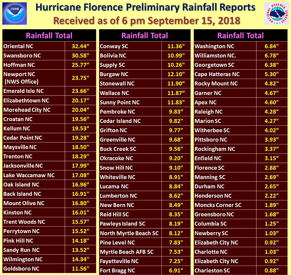
RAINFALL: Florence is expected to produce heavy and excessive
rainfall in the following areas...

Southern and central portions of North Carolina into far northeast
South Carolina...an additional 15 to 20 inches, with storm totals
between 30 and 40 inches along the North Carolina coastal areas
south of Cape Hatteras. This rainfall will continue to produce
catastrophic flash flooding and prolonged significant river
flooding.

Remainder of northern South Carolina into western North Carolina and
southwestern Virginia...5 to 10 inches, isolated 15 inches.

West-central Virginia into far eastern West Virginia, north of
Roanoke and west of Charlottesville, 3 to 6 inches, isolated 8
inches. These rainfall amounts will result in life-threatening
flash flooding and river flooding, along with an elevated risk for
landslides.

WIND: Tropical storm conditions will continue overnight in portions
of the warning area along the coast and also over large portions of
eastern North Carolina and extreme eastern South Carolina, with
tropical-storm-force wind gusts spreading well inland.

TORNADOES: A few tornadoes are possible in southeastern North
Carolina and northeastern South Carolina through tonight.

SURF: Swells generated by Florence are affecting Bermuda, portions
of the U.S. East Coast, and the northwestern and central Bahamas.
These swells are likely to cause life-threatening surf and rip
current conditions. Please consult products from your local weather
office.


NEXT ADVISORY
-------------
Next complete advisory at 1100 PM EDT.

$$
Forecaster Berg

https://www.nhc.noaa.gov/text/refresh/MIATCPAT1+shtml/152339.shtml

 
HURRICANE FLORENCE 1 hour ago

Weakened Florence remains dangerous as it works its way North

Lucia Suarez Sang By Lucia I. Suarez Sang | Fox News

Downgraded from hurricane to tropical depression, Florence continued Monday to wreak havoc in the Carolinas as it works its way north, dropping massive amounts of rainwater and flooding already saturated rivers.

The storm has already claimed the lives of 17 peoples ? including a 3-month-old who died after a pine tree crashed into a mobile home in Dallas, North Carolina. Officials blamed rain and wind from the remnants of the storm for causing the tree to fall, county spokesman James McConnell told the AP.
...
Despite its downgraded classification, Florence remains massive -- and a threat. Radar showed parts of the sprawling storm over six states, with North and South Carolina in the bullseye. Flash flood watches and warnings were still in effect.

Forecasters said Florence is expected to weaken some before re-intensifying as it transitions to an extratropical cyclone through Wednesday.
...
Meanwhile, the city of Wilmington, N.C., has been completely cut off by floodwaters and officials are asking for additional help from the National Guard.
...
http://www.foxnews.com/us/2018/09/1...ains-dangerous-as-it-works-its-way-north.html
 
Pig Excrement Spills Into North Carolina Floodwater

By Mark Niquette , Ari Natter , and Justina Vasquez
September 18, 2018, 4:01 AM CDT Updated on September 18, 2018, 12:19 PM CDT
...
Hurricane-wracked North Carolina faced a health and environmental crisis after at least 17 hog-waste lagoons were compromised and sewage plants across the state flooded, releasing millions of gallons of partially treated human discharge.
...
?We don?t think it?s a good idea for people to be swimming around in poop,? said John Rumpler, clean water program director for Environment America, a Colorado-based advocacy group. ?It?s a pretty serious public-health risk that people should be concerned about.?

Four days after deadly Hurricane Florence made landfall, much of the Tar Heel State?s low-lying east remained flooded and impassible. The storm, blamed for killing at least 34 people, damaged a Duke Energy Corp. coal-ash landfill and trapped workers at one of its nuclear plants near stricken Wilmington. The disaster, forecast to cost $22 billion, was wreaking havoc in myriad ways:
...
Hog waste contains E. coli and bacteria, Rumpler said. Sewage overflows, combined with high floodwaters, bring the prospect of ecological impacts including fish kills. Humans coming into contact with fecal matter risk viruses, parasitic infections and rashes.

?There are a lot of potentially nasty pathogens,? said Tara Smith, a professor of epidemiology at Kent State University in Ohio.
...
There is also the possibility of contamination from dead livestock, Smith said. Tens of thousands of hogs died in Floyd, but no similar tally could yet be made for Florence. But late Monday, Sanderson Farms Inc., one of the largest U.S. poultry companies, said that 60 North Carolina chicken houses and four breeding facilities were flooded. It estimated 1.7 million chickens were lost, and another 30 farms with about 211,000 birds each can?t get feed. More poultry may die if relief can?t get through, the company said.
...
That flowing water is itself polluted. North Carolina utilities reported that millions of gallons of raw sewage and partially treated wastewater were released into lakes, streams and city streets after systems lost power or were overwhelmed by rainfall that reached 40 inches in some places. Seven publicly owned sewage treatment plants aren?t working, the U.S. Environmental Protection Agency said.
...

https://www.bloomberg.com/news/arti...rolina-hog-waste-lagoons-flooded-by-hurricane
 
Back
Top