
Install the app
How to install the app on iOS
Follow along with the video below to see how to install our site as a web app on your home screen.
Note: This feature may not be available in some browsers.
-
FluTrackers.com Inc. does not provide medical advice. Information on this web site is collected from various internet resources, and the FluTrackers board of directors makes no warranty to the safety, efficacy, correctness or completeness of the information posted on this site by any author or poster. The information collated here is for instructional and/or discussion purposes only and is NOT intended to diagnose or treat any disease, illness, or other medical condition. Every individual reader or poster should seek advice from their personal physician/healthcare practitioner before considering or using any interventions that are discussed on this website. By continuing to access this website you agree to consult your personal physican before using any interventions posted on this website, and you agree to hold harmless FluTrackers.com Inc., the board of directors, the members, and all authors and posters for any effects from use of any medication, supplement, vitamin or other substance, device, intervention, etc. mentioned in posts on this website, or other internet venues referenced in posts on this website. -
We are not asking for any donations. Do not donate to any entity who says they are raising funds for us.
- Home
- Forums
- Forum
- United States
- Other diseases
- Seasonal Flu 2009+, including H1N1 pandemic 2009
- New Mexico
You are using an out of date browser. It may not display this or other websites correctly.
You should upgrade or use an alternative browser.
You should upgrade or use an alternative browser.
New Mexico Surveillance in Border Region - Dramatic Jump in ILI Revised Downward
- Thread starter JimO
- Start date
Laidback Al
Well-known member
Re: New Mexico Surveillance in Border Region - Dramatic Jump in ILI in Mexico
Re: New Mexico Surveillance in Border Region - Dramatic Jump in ILI in Mexico
Col is an abbreviation for colonia. From wikipedia:
Here is a street view of the front entrance from Google.

Re: New Mexico Surveillance in Border Region - Dramatic Jump in ILI in Mexico
<small>
This map shows my best guess for the location of Centro de Salud B, Juarez, Chihuahua, Mex.
I searched high and low for the map location of Centro de Salud B, which pops up in numerous recent flu vaccination-related news articles but I could not locate it. It may be a large center that was recently expanded. The only address (see below) I found, places the Center at Juarez and Vicente Guerreros Aves</small><small>, shown by the green icons. </small><small>Juarez Ave. appears to be Fed. Hwy. Mexico 45 as well. I found a small cluster of pharmacies near this intersection, which tells me there could be a health care delivery center somewhere around.
On the other hand, the largest cluster of pharmacies on Vicente Guerreros is near "Centro" about 5 miles due west--when you zoom out. Unfortunately, I do not know what "Col Centro" (below) means. Could this be the location of B instead?
I thought "B" could stand for "Benito Juarez" but I found no confirmation for this either.
Centro de Salud ?B?
Av. Ju?rez y Vicente Guerrero s/n
Col Centro
Cd. Ju?rez, Chihuahua, M?xico
Tel?fono 612-3162
Hope this helps
</small>
Col is an abbreviation for colonia. From wikipedia:
Sorry you went to all this effort LaMenchos. I posted a location map yesterday for Centro de Salud "B" in post #13 in this thread.In general, colonias are neighborhoods in Mexican cities, which have no jurisdictional autonomy or representation. It is plausible that the name, which literally means colony, arose in the late 19th, early 20th centuries, when one of the first urban developments outside Mexico City's core was inhabited by a French colony in the city. Usually colonias are assigned a specific postal code; nonetheless, in recent urban developments, gated communities are also defined as colonias and share the postal code with adjacent neighborhoods. In spite of this, the name of the colonia must be specified when writing an address in large urban areas in Mexico.
Here is a street view of the front entrance from Google.
Re: New Mexico Surveillance in Border Region - Dramatic Jump in ILI in Mexico
Re: New Mexico Surveillance in Border Region - Dramatic Jump in ILI in Mexico
Fantastic! And thank you for all that info, Laidback Al.
As I often say "You guys" are great! :tiphat:
Reporting errors are probably not rare. At some point, I would suspect that they may be even common. If nothing else, it's a statistical given. In the case of a pandemic, is it informative to know and, if so, publish what are both the frequency of errors and its range of variation?
Re: New Mexico Surveillance in Border Region - Dramatic Jump in ILI in Mexico
Fantastic! And thank you for all that info, Laidback Al.
As I often say "You guys" are great! :tiphat:
Reporting errors are probably not rare. At some point, I would suspect that they may be even common. If nothing else, it's a statistical given. In the case of a pandemic, is it informative to know and, if so, publish what are both the frequency of errors and its range of variation?
Laidback Al
Well-known member
Re: New Mexico Surveillance in Border Region - Dramatic Jump in ILI in Mexico
Re: New Mexico Surveillance in Border Region - Dramatic Jump in ILI in Mexico
Link to border report archives under Surveillance Report on this page:
http://nmhealth.org/flu/weekly_reports.shtml
Re: New Mexico Surveillance in Border Region - Dramatic Jump in ILI in Mexico
apparantly those border-reports are not listed officially
and linked to on some official webpage.
I did find one with google-search and then guessing
the URLs of the others.
They used different URLs for weeks 7,8 - hard to guess,
and some of the weeks couldn't be found.
Also, is there an archive for previous years ?
Link to border report archives under Surveillance Report on this page:
http://nmhealth.org/flu/weekly_reports.shtml

gsgs
Registered User
Re: New Mexico Surveillance in Border Region - Dramatic Jump in ILI in Mexico
Re: New Mexico Surveillance in Border Region - Dramatic Jump in ILI in Mexico
thanks. Probably I didn't scroll down.
Googling for the URL wasn't successful.
Some of the reports were not found,The URLs are not uniform
http://nmhealth.org/flu/Border_Reports_10-11.shtml
http://nmhealth.org/flu/Border_Reports_09-10.shtml
http://nmhealth.org/flu/Border_Reports_08-09.shtml
2008/09:
the 3 Juarez-hospitals started reporting since 2008/10/25
80/1,449/0,226/0
93/1,527/0,112/0
88/1,505/0,240/0
71/0,525/0,263/1
74/0,495/0,202/6
117/0,506/0,301/3
92/0,598/0,201/1
no report,512/0,270/1
---,---,---
98/0,518/0,243/2
96/3,598/0,301/3
92/1,610/0,293/8
95/0,559/7,280/16
75/2,536/8,232/9
75/1,598/5,264/19
94/3,577/5,283/14
74/1,109/4,357/42 2009/02/28
67/2,157/6,292/19
87/1,137/5,269/10
893/0,120/1,236/5
894/2,154/6,289/6
832/1,111/0,275/2
721/1,93/0,189/2
854/0,102/7,188/1
906/5,101/0,176/14
769/7,169/26,765/40
620/11,54/18,1260/55
877/15,54/13,333/45 2009/05/16
864/10,96/1,255/38
report error,128/2,289/34
not available
848/7,106/0,365/18
770/1,82/0,343/13
no report,no report,no report
769/7,169/26,75/40
847/0,51/0,340/1
853/0,49/0,288/4
not available
908/0,65/0,202/4
2009/10: with UTEP El Paso and total
915/9,745/0,1192/39,156/5,5737/500
726/9,690/7,909/8,131/10,4562/211
443/4,541/12,1303/3,158/2,5138/231
330/2,525/2,912/2,173/7,3989/105
403/1,573/0,946/3,189/5,4194,121
...
2011 weekly patients in 3 major hospitals in Juarez
week atients/ILI-patients
07:226/0,847/2,1224/4
08:226/0,847/0,1146/9
09:244/0,859/1,1134/0
10:275/0,851/0,1134/0
11:?/0,?/0,1000/1
12:298/67,697/6,1132/24
13:631/7,892/1,1122/50
14:552/355,947/2,1095/50
12:298/67,697/6,1132/24,?/?,3318/100
13:631/7,892/1,1122/50,?/?,3977/66
14:552/355,947/2,1095/50,?/?,4089/410
15:?/?,914/2,1068/2,?/?,3404/7
so, you see how this increase in week 14/2011 is unprecedented
and dramatical - if true.
The number of patients per week did change a lot before,
e.g. in March 2009 almost 10-fold for Aguilas, this could be some
reorganisation or a new department/building starts taking patients
Re: New Mexico Surveillance in Border Region - Dramatic Jump in ILI in Mexico
thanks. Probably I didn't scroll down.
Googling for the URL wasn't successful.
Some of the reports were not found,The URLs are not uniform
http://nmhealth.org/flu/Border_Reports_10-11.shtml
http://nmhealth.org/flu/Border_Reports_09-10.shtml
http://nmhealth.org/flu/Border_Reports_08-09.shtml
2008/09:
the 3 Juarez-hospitals started reporting since 2008/10/25
80/1,449/0,226/0
93/1,527/0,112/0
88/1,505/0,240/0
71/0,525/0,263/1
74/0,495/0,202/6
117/0,506/0,301/3
92/0,598/0,201/1
no report,512/0,270/1
---,---,---
98/0,518/0,243/2
96/3,598/0,301/3
92/1,610/0,293/8
95/0,559/7,280/16
75/2,536/8,232/9
75/1,598/5,264/19
94/3,577/5,283/14
74/1,109/4,357/42 2009/02/28
67/2,157/6,292/19
87/1,137/5,269/10
893/0,120/1,236/5
894/2,154/6,289/6
832/1,111/0,275/2
721/1,93/0,189/2
854/0,102/7,188/1
906/5,101/0,176/14
769/7,169/26,765/40
620/11,54/18,1260/55
877/15,54/13,333/45 2009/05/16
864/10,96/1,255/38
report error,128/2,289/34
not available
848/7,106/0,365/18
770/1,82/0,343/13
no report,no report,no report
769/7,169/26,75/40
847/0,51/0,340/1
853/0,49/0,288/4
not available
908/0,65/0,202/4
2009/10: with UTEP El Paso and total
915/9,745/0,1192/39,156/5,5737/500
726/9,690/7,909/8,131/10,4562/211
443/4,541/12,1303/3,158/2,5138/231
330/2,525/2,912/2,173/7,3989/105
403/1,573/0,946/3,189/5,4194,121
...
2011 weekly patients in 3 major hospitals in Juarez
week
atients/ILI-patients07:226/0,847/2,1224/4
08:226/0,847/0,1146/9
09:244/0,859/1,1134/0
10:275/0,851/0,1134/0
11:?/0,?/0,1000/1
12:298/67,697/6,1132/24
13:631/7,892/1,1122/50
14:552/355,947/2,1095/50
12:298/67,697/6,1132/24,?/?,3318/100
13:631/7,892/1,1122/50,?/?,3977/66
14:552/355,947/2,1095/50,?/?,4089/410
15:?/?,914/2,1068/2,?/?,3404/7
so, you see how this increase in week 14/2011 is unprecedented
and dramatical - if true.
The number of patients per week did change a lot before,
e.g. in March 2009 almost 10-fold for Aguilas, this could be some
reorganisation or a new department/building starts taking patients
Attachments
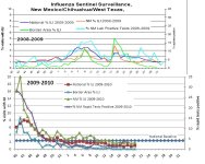

sharon sanders
Editor-in-Chief & President
Re: New Mexico Surveillance in Border Region - Dramatic Jump in ILI in Mexico
Re: New Mexico Surveillance in Border Region - Dramatic Jump in ILI in Mexico
We have not changed the title of this thread because the border report does still indicate a dramatic increase in ILI in week 14 for the Aquilas clinic in Cuidad Juarez.
This requires scrutiny.
So what is happening here?
Clearly there is a flu outbreak in the Juarez/El Paso area. The PAHO report indicates A/H1N1 activity this year in: Ecuador. Mexico, Venezuela, Dominican Republic, Cuba, Colombia, Honduras, Jamaica and El Salvador.
Furthermore, this reports recommends vigilance for the Americas and implementation of pandemic preparedness plans. This is prudent action.
So what does the average person do? Stay alert to flu activity in your community. Contact your health practitioner about flu and the flu vaccine. Wash your hands frequently. Stay out of crowded areas. If someone gets sick in your household, contact their health practitioner and keep them isolated away from other family members. Now is the time to stop smoking, and also, lose those extra pounds.
As we have seen, A/H1N1 can be very deadly to pregnant women. If you are pregnant, take special precautions regarding flu prevention. Some are listed above. Contact your health practitioner about the flu about what you can do.
There are a lot of rumours about A/H1N1 at this time regarding this outbreak and the PAHO report. People always question the motivations of people who are "hyping" the level of discourse.
This is not the case here at FT. We operate this site as parents. Some of us are medical doctors, some have PhDs, but mostly, we are moms and dads.
We are very concerned about the spread of A/H1N1. In fact, the pandemic is really not "over". The world is experiencing the continuing waves of A/H1N1 that started in 2009. All persons should be vigilant about this disease because, as time progresses, the evolution of the genetic code of the various A/H1N1 strains will render the vaccine less and less effective. Anti-viral medicine that has worked so well in the past is gradually losing its effectiveness too.
And, there is always the chance that A/H1N1, which is fully humanized, may pick up some genetic characteristics that might make it more lethal. The currently circulating A/H5N1 is a candidate for this process.
Overall, it is our recommendation that all persons in the world remain vigilant about the flu. The pandemic is not over, and in fact, with the novel strains of A/H5N1, trH3N2 circulating we are in a more dangerous position than ever.
If you have any questions about what is going on in your community and you do not trust the media and/or government officials, then look around. How many people do you know are sick with the flu or severe respiratory illnesses? Are they hospitalized? For how long? Are they young? Pregnant? Are there lines outside the emergency rooms? The pharmacies? Is it difficult to contact your doctor because their patient load has suddenly increased? Are staple food products disappearing off the shelves of your grocery store?
You are not powerless. You can look for yourself.
Re: New Mexico Surveillance in Border Region - Dramatic Jump in ILI in Mexico
We have not changed the title of this thread because the border report does still indicate a dramatic increase in ILI in week 14 for the Aquilas clinic in Cuidad Juarez.
This requires scrutiny.
So what is happening here?
Clearly there is a flu outbreak in the Juarez/El Paso area. The PAHO report indicates A/H1N1 activity this year in: Ecuador. Mexico, Venezuela, Dominican Republic, Cuba, Colombia, Honduras, Jamaica and El Salvador.
Furthermore, this reports recommends vigilance for the Americas and implementation of pandemic preparedness plans. This is prudent action.
So what does the average person do? Stay alert to flu activity in your community. Contact your health practitioner about flu and the flu vaccine. Wash your hands frequently. Stay out of crowded areas. If someone gets sick in your household, contact their health practitioner and keep them isolated away from other family members. Now is the time to stop smoking, and also, lose those extra pounds.
As we have seen, A/H1N1 can be very deadly to pregnant women. If you are pregnant, take special precautions regarding flu prevention. Some are listed above. Contact your health practitioner about the flu about what you can do.
There are a lot of rumours about A/H1N1 at this time regarding this outbreak and the PAHO report. People always question the motivations of people who are "hyping" the level of discourse.
This is not the case here at FT. We operate this site as parents. Some of us are medical doctors, some have PhDs, but mostly, we are moms and dads.
We are very concerned about the spread of A/H1N1. In fact, the pandemic is really not "over". The world is experiencing the continuing waves of A/H1N1 that started in 2009. All persons should be vigilant about this disease because, as time progresses, the evolution of the genetic code of the various A/H1N1 strains will render the vaccine less and less effective. Anti-viral medicine that has worked so well in the past is gradually losing its effectiveness too.
And, there is always the chance that A/H1N1, which is fully humanized, may pick up some genetic characteristics that might make it more lethal. The currently circulating A/H5N1 is a candidate for this process.
Overall, it is our recommendation that all persons in the world remain vigilant about the flu. The pandemic is not over, and in fact, with the novel strains of A/H5N1, trH3N2 circulating we are in a more dangerous position than ever.
If you have any questions about what is going on in your community and you do not trust the media and/or government officials, then look around. How many people do you know are sick with the flu or severe respiratory illnesses? Are they hospitalized? For how long? Are they young? Pregnant? Are there lines outside the emergency rooms? The pharmacies? Is it difficult to contact your doctor because their patient load has suddenly increased? Are staple food products disappearing off the shelves of your grocery store?
You are not powerless. You can look for yourself.
gsgs
Registered User
Re: New Mexico Surveillance in Border Region - Dramatic Jump in ILI in Mexico
Re: New Mexico Surveillance in Border Region - Dramatic Jump in ILI in Mexico
someone else to help typing such numbers into the computer
so we can make charts and statistics ?
These are often only available in .pdf
Mexican reported H3 numbers show a H3-wave in Mexico in weeks 30-52, 2010
but apparantly nothing in Juarez
do those regions that had H3N2 also have H1N1 now ?
Re: New Mexico Surveillance in Border Region - Dramatic Jump in ILI in Mexico
someone else to help typing such numbers into the computer
so we can make charts and statistics ?
These are often only available in .pdf
Mexican reported H3 numbers show a H3-wave in Mexico in weeks 30-52, 2010
but apparantly nothing in Juarez
do those regions that had H3N2 also have H1N1 now ?
sharon sanders
Editor-in-Chief & President
Re: New Mexico Surveillance in Border Region - Dramatic Jump in ILI in Mexico
Re: New Mexico Surveillance in Border Region - Dramatic Jump in ILI in Mexico
There have been no new reports since the April 9 report. In previous months it appears the reports were issued weekly.
In the 200-2010 flu season reports were issued weekly from October - May, inclusive:
2009 - 2010 Influenza Surveillance archives
October Reports
 Week Ending 10/03/09
Week Ending 10/10/09
Week Ending 10/17/09
Week Ending 10/24/09
Week Ending 10/31/09
November Reports
Week Ending 11/07/09
Week Ending 11/14/09
Week Ending 11/21/09
Week Ending 11/28/09
December Reports
Week Ending 12/05/09
Week Ending 12/12/09
Week Ending 12/19/09
Week Ending 12/26/09
January Reports
Week Ending 01/02/10
Week Ending 01/09/10
Week Ending 01/16/10
Week Ending 01/23/10
Week Ending 01/30/10
February Reports
Week Ending 02/06/10
Week Ending 02/13/10
Week Ending 02/20/10
Week Ending 02/27/10
March Reports
Week Ending 03/06/10
Week Ending 03/13/10
Week Ending 03/20/10
Week Ending 03/27/10
April Reports
Week Ending 04/03/10
Week Ending 04/10/10
Week Ending 04/17/10
Week Ending 04/24/10
May Reports
Week Ending 05/01/10
Week Ending 05/08/10
Week Ending 05/15/10
Week Ending 05/22/10
Week Ending 05/29/10
http://www.health.state.nm.us/flu/report_archives_09-10.shtml
So......err......what is the deal?

Re: New Mexico Surveillance in Border Region - Dramatic Jump in ILI in Mexico
There have been no new reports since the April 9 report. In previous months it appears the reports were issued weekly.
In the 200-2010 flu season reports were issued weekly from October - May, inclusive:
2009 - 2010 Influenza Surveillance archives
October Reports
November Reports
December Reports
Week Ending 12/05/09 Week Ending 12/12/09 Week Ending 12/19/09 Week Ending 12/26/09January Reports
Week Ending 01/02/10 Week Ending 01/09/10 Week Ending 01/16/10 Week Ending 01/23/10
February Reports
Week Ending 02/06/10 Week Ending 02/13/10 Week Ending 02/20/10 Week Ending 02/27/10March Reports
Week Ending 03/06/10 Week Ending 03/13/10 Week Ending 03/20/10 Week Ending 03/27/10April Reports
Week Ending 04/03/10 Week Ending 04/10/10 Week Ending 04/17/10 Week Ending 04/24/10May Reports
Week Ending 05/01/10 Week Ending 05/08/10 Week Ending 05/15/10 Week Ending 05/22/10 Week Ending 05/29/10http://www.health.state.nm.us/flu/report_archives_09-10.shtml
So......err......what is the deal?

JimO
Well-known member
Re: New Mexico Surveillance in Border Region - Dramatic Jump in ILI Revised Downward
http://nmhealth.org/flu/documents/WeeklyReportBISN.Eng.10-11.Wk15.pdf
The %ILI has been revised dramatically downward for Weeks 12, 13, and 14 as compared with the chart from Week 14. Also, the links to the reports for Weeks 13 and 14 have been deactivated. If that was an error, then it was a whopper. The only other possibility is that somebody didn't like the data. It is interesting that the number for Week 12, which was only slightly above baseline, has been revised down below baseline. I can understand an error with the Week 14 number, but changes to three weeks worth of data is suspicious to me. It's as though someone did not want to show and increasing trend in %ILI.
I might also add that there is no explanation (or even mention) of the chart revisions. Such a substantial revision of three weeks' worth of data, particularly in a region where there has been significant concern over recent cases and deaths, is certainly warranted.
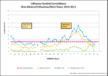
http://nmhealth.org/flu/documents/WeeklyReportBISN.Eng.10-11.Wk15.pdf
The %ILI has been revised dramatically downward for Weeks 12, 13, and 14 as compared with the chart from Week 14. Also, the links to the reports for Weeks 13 and 14 have been deactivated. If that was an error, then it was a whopper. The only other possibility is that somebody didn't like the data. It is interesting that the number for Week 12, which was only slightly above baseline, has been revised down below baseline. I can understand an error with the Week 14 number, but changes to three weeks worth of data is suspicious to me. It's as though someone did not want to show and increasing trend in %ILI.
I might also add that there is no explanation (or even mention) of the chart revisions. Such a substantial revision of three weeks' worth of data, particularly in a region where there has been significant concern over recent cases and deaths, is certainly warranted.
sharon sanders
Editor-in-Chief & President
Re: New Mexico Surveillance in Border Region - Dramatic Jump in ILI Revised Downward
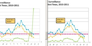
I uploaded the report from week 14 onto our server here. The week 14 report also contains the figures for week 13.
Most of us trackers have seen news reports etc. disappear after questions are asked.
I agree. A revision to public health data should be accompanied by an explanation at the time of revision.
:magnify:
I uploaded the report from week 14 onto our server here. The week 14 report also contains the figures for week 13.
Most of us trackers have seen news reports etc. disappear after questions are asked.
I agree. A revision to public health data should be accompanied by an explanation at the time of revision.
:magnify:
sharon sanders
Editor-in-Chief & President
Re: New Mexico Surveillance in Border Region - Dramatic Jump in ILI Revised Downward
Dr. Lopez said the 355 number was a mistake so, therefore, there was no huge difference between the Aguilas clinic and the other clinics.

Dr. Lopez said the 355 number was a mistake so, therefore, there was no huge difference between the Aguilas clinic and the other clinics.
JimO
Well-known member
Re: New Mexico Surveillance in Border Region - Dramatic Jump in ILI Revised Downward
That still doesn't explain why they changed the numbers for Weeks 12 and 13 at the same time.
That still doesn't explain why they changed the numbers for Weeks 12 and 13 at the same time.
Dr. Lopez said the 355 number was a mistake so, therefore, there was no huge difference between the Aguilas clinic and the other clinics.
sharon sanders
Editor-in-Chief & President
Re: New Mexico Surveillance in Border Region - Dramatic Jump in ILI Revised Downward
Agreed. Odd.
That still doesn't explain why they changed the numbers for Weeks 12 and 13 at the same time.
Agreed. Odd.
JimO
Well-known member
Re: New Mexico Surveillance in Border Region - Dramatic Jump in ILI Revised Downward
Yes, they changed the graph. Sharon pasted them side by side. What puzzles me is that they not only changed the value for Week 14, but they also changed the Week 12 value so that it is now below baseline.
Yes, they changed the graph. Sharon pasted them side by side. What puzzles me is that they not only changed the value for Week 14, but they also changed the Week 12 value so that it is now below baseline.
you mean, the graph was changed ?
the numbers in the old reports are still the same
they just removed Aguilas from the list
Laidback Al
Well-known member
Re: New Mexico Surveillance in Border Region - Dramatic Jump in ILI Revised Downward
Indeed the graph have changed and the links to the original data for weeks 12 - 14 have been deactivated.
I checked archive of the border reports back to 2007. (link) For the past four years the reporting format has been the same. It has always been weekly counts, not cumulative counts, or running averages. I think Dr. Lopez needs to provide more of an explanation of the "mistake", especially a recurring "mistake" over three reporting periods.
For those who are curious, I have attached the original pdf files from weeks 12 -14 showing the higher numbers than are shown on the current graph.
View attachment BISN Week 12.PDF
View attachment BISN Week 13.PDF
View attachment BISN Week 14.PDF
Yes, they changed the graph. Sharon pasted them side by side. What puzzles me is that they not only changed the value for Week 14, but they also changed the Week 12 value so that it is now below baseline.
Indeed the graph have changed and the links to the original data for weeks 12 - 14 have been deactivated.
Dr. Lopez said the 355 number was a mistake so, therefore, there was no huge difference between the Aguilas clinic and the other clinics.
I checked archive of the border reports back to 2007. (link) For the past four years the reporting format has been the same. It has always been weekly counts, not cumulative counts, or running averages. I think Dr. Lopez needs to provide more of an explanation of the "mistake", especially a recurring "mistake" over three reporting periods.
For those who are curious, I have attached the original pdf files from weeks 12 -14 showing the higher numbers than are shown on the current graph.
View attachment BISN Week 12.PDF
View attachment BISN Week 13.PDF
View attachment BISN Week 14.PDF
gsgs
Registered User
Re: New Mexico Surveillance in Border Region - Dramatic Jump in ILI Revised Downward
the files are still there
http://nmhealth.org/flu/documents/WeeklyReportBISN.Eng.10-11.Wk12.pdf
http://nmhealth.org/flu/documents/WeeklyReportBISN.Eng.10-11.Wk13.pdf
http://nmhealth.org/flu/documents/WeeklyReportBISN.Eng.10-11.Wk14.pdf
http://nmhealth.org/flu/documents/WeeklyReportBISN.Eng.10-11.Wk15.pdf
what could have been the "error" ?
they counted vaccinees as ILIs ?
one doctor changed the rule, what counts as ILI ?
--------------------
they also renamed the April reports as March reports
http://nmhealth.org/flu/Border_Reports_10-11.shtml
the files are still there
http://nmhealth.org/flu/documents/WeeklyReportBISN.Eng.10-11.Wk12.pdf
http://nmhealth.org/flu/documents/WeeklyReportBISN.Eng.10-11.Wk13.pdf
http://nmhealth.org/flu/documents/WeeklyReportBISN.Eng.10-11.Wk14.pdf
http://nmhealth.org/flu/documents/WeeklyReportBISN.Eng.10-11.Wk15.pdf
what could have been the "error" ?
they counted vaccinees as ILIs ?
one doctor changed the rule, what counts as ILI ?
--------------------
they also renamed the April reports as March reports
http://nmhealth.org/flu/Border_Reports_10-11.shtml
gsgs
Registered User
Re: New Mexico Surveillance in Border Region - Dramatic Jump in ILI Revised Downward
week 16: http://nmhealth.org/flu/documents/WeeklyReportBISN.Eng.10-11.Wk16.pdf
week 17: http://nmhealth.org/flu/documents/WeeklyReportBISN.Eng.10-11.Wk17.pdf
week 18: http://nmhealth.org/flu/documents/WeeklyReportBISN.Eng.10-11.Wk18.pdf
week 19: http://nmhealth.org/flu/documents/WeeklyReportBISN.Eng.10-11.Wk19.pdf
Aguilas is in again in week 17 , 4 ILI out of 276 total patients
week 16: http://nmhealth.org/flu/documents/WeeklyReportBISN.Eng.10-11.Wk16.pdf
week 17: http://nmhealth.org/flu/documents/WeeklyReportBISN.Eng.10-11.Wk17.pdf
week 18: http://nmhealth.org/flu/documents/WeeklyReportBISN.Eng.10-11.Wk18.pdf
week 19: http://nmhealth.org/flu/documents/WeeklyReportBISN.Eng.10-11.Wk19.pdf
Aguilas is in again in week 17 , 4 ILI out of 276 total patients
gsgs
Registered User
Re: New Mexico Surveillance in Border Region - Dramatic Jump in ILI Revised Downward
http://nmhealth.org/flu/BorderReports11_12/WeeklyReportBISN.Eng.11-12.Wk5.pdf
the US-military reported "clusters of H1N1v at US-clinics near the
Mexican border in mid-January 2012
mixin1771 [12:26]: deaths in mexico from H1N1 up 67% in one week
mixin1771 [12:26]: The total number of deaths from AH1N1 flu reported by Mexico’s Health Secretariat up to Feb. 9 was 81, with another 54 the following week.
mixin1771 [12:27]: deaths from the AH1N1 strain of flu from Jan. 1 to Feb. 16 represents 91 percent of the 149 fatalities from the different types of flu now active in the country.
http://www.laht.com/article.asp?CategoryId=14091&ArticleId=471606
El Paso:
01 131 95 25 6 2 3 2
02 118 87 21 4 3 3 1
03 133 90 30 8 3 2 4
04 95 64 25 3 2 1 3
05 102 74 17 5 3 3 4
06 66 47 11 4 1 3 4
07 106 76 19 6 2 3 3
08 100 78 16 3 1 2 1
09 111 78 26 3 3 1 4
10 116 78 29 6 1 2 7
11 89 69 15 2 3 - 6
12 114 81 24 6 2 1 8
http://nmhealth.org/flu/BorderReports11_12/WeeklyReportBISN.Eng.11-12.Wk10.pdf
http://nmhealth.org/flu/BorderReports11_12/WeeklyReportBISN.Eng.11-12.Wk5.pdf
the US-military reported "clusters of H1N1v at US-clinics near the
Mexican border in mid-January 2012
mixin1771 [12:26]: deaths in mexico from H1N1 up 67% in one week
mixin1771 [12:26]: The total number of deaths from AH1N1 flu reported by Mexico’s Health Secretariat up to Feb. 9 was 81, with another 54 the following week.
mixin1771 [12:27]: deaths from the AH1N1 strain of flu from Jan. 1 to Feb. 16 represents 91 percent of the 149 fatalities from the different types of flu now active in the country.
http://www.laht.com/article.asp?CategoryId=14091&ArticleId=471606
El Paso:
01 131 95 25 6 2 3 2
02 118 87 21 4 3 3 1
03 133 90 30 8 3 2 4
04 95 64 25 3 2 1 3
05 102 74 17 5 3 3 4
06 66 47 11 4 1 3 4
07 106 76 19 6 2 3 3
08 100 78 16 3 1 2 1
09 111 78 26 3 3 1 4
10 116 78 29 6 1 2 7
11 89 69 15 2 3 - 6
12 114 81 24 6 2 1 8
http://nmhealth.org/flu/BorderReports11_12/WeeklyReportBISN.Eng.11-12.Wk10.pdf