• FluTrackers.com Inc. does not provide medical advice. Information on this web site is collected from various internet resources, and the FluTrackers board of directors makes no warranty to the safety, efficacy, correctness or completeness of the information posted on this site by any author or poster. The information collated here is for instructional and/or discussion purposes only and is NOT intended to diagnose or treat any disease, illness, or other medical condition. Every individual reader or poster should seek advice from their personal physician/healthcare practitioner before considering or using any interventions that are discussed on this website. By continuing to access this website you agree to consult your personal physican before using any interventions posted on this website, and you agree to hold harmless FluTrackers.com Inc., the board of directors, the members, and all authors and posters for any effects from use of any medication, supplement, vitamin or other substance, device, intervention, etc. mentioned in posts on this website, or other internet venues referenced in posts on this website.
  • We are not asking for any donations. Do not donate to any entity who says they are raising funds for us.

Louisiana: Assumption Parish Bayou Corne Sinkhole 2012-2015

Re: Louisiana: Assumption Parish Bayou Corne Sinkhole 2012

Re: Louisiana: Assumption Parish Bayou Corne Sinkhole 2012

There was rumbling again in Bayou Corne this past weekend that was attributed to seismic waves passing through the area from the big earthquake off the coast of SE Alaska:
http://www.wafb.com/story/20521963/group-wants-sinkhole-declared-federal-disaster

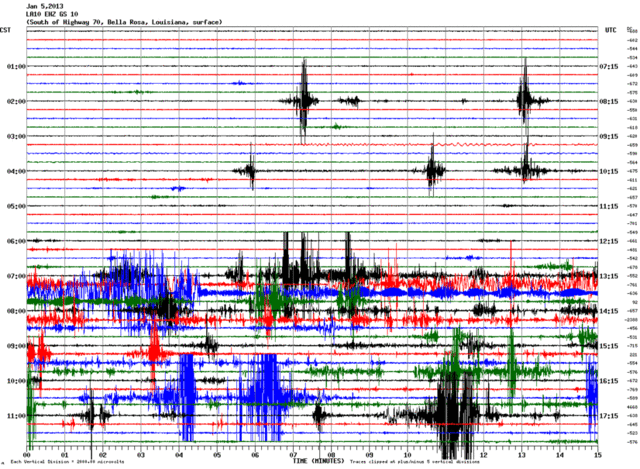
The parish blog says the waves hit at about 3 am local time on Saturday, Jan. 5th. You can see them clearly on the helicorders - with another distinct pattern at about 7 am local time. One sensor only picked up only the later pattern. To me, that indicates some activity in the area might have been triggered by the waves.

http://folkworm.ceri.memphis.edu/heli_temp/
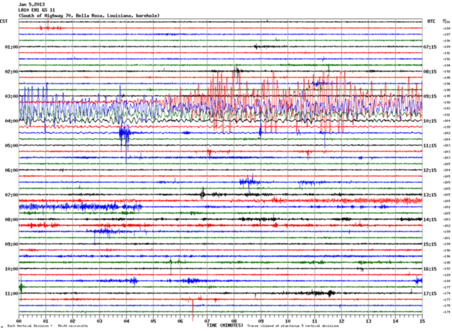
AKearthquakeLA10_EH1_GS_112013010500.gif


AKearthquakeLA03_BHZ_GS_002013010500.gif


AKearthquakeLA01_BHZ_GS_002013010500.gif


AKearthquakeLA10_EHZ_GS_102013010500.gif


The parish blog also said:
The Office of Conservation has advised Assumption Parish officials of that detection because, though the Alaska quake was too far away to have any effect on subsurface stability in Louisiana, local officials and residents monitoring the seismic recordings should be informed that the readings for that period do not indicate a change in conditions in or near the Napoleonville Salt Dome.

Maybe in this case stability was not affected, but I saw research that does link energy waves to microseismicity during salt cavern collapse. Seismic waves generated by an M∼7.2 earthquake at more than 10000 km from a salt cavern in France are studied. The link below has the whole text of the paper in either HTML or PDF format, but I would read it soon if you are interested, since most links have only the abstract.

Evidence for remotely triggered microearthquakes during salt cavern collapse

I think that one of the key points in that article is that a cavern has to be in a very compromised state already to be affected by seismic waves from distant earthquakes. They are a triggering mechanism, not the cause of the collapse or related seismic activity.

The Bayou Corne bubbling was first officially reported on May 30th of 2012, I believe, but processes related to collapse might have started earlier. There were a couple of unusual earthquakes reported in the Spring of 2012:

The April 11, 2012 Sumatra great earthquake sequence

May 20, 2012 M6.0 thrust earthquake in Italy

Even if the timing is proven to be off on those two, the article on the cavern collapse in France raises the possibility that even Earth tides can induce microearthquakes in unstable systems. I guess the relevant point to Bayou Corne is that the research article and the way the Alaska earthquake affected the failed cavern there supports that any seismicity related to the cavern collapse there was caused by the cavern's instability, rather than the other way around.
 
Last edited:
Re: Louisiana: Assumption Parish Bayou Corne Sinkhole 2012

Re: Louisiana: Assumption Parish Bayou Corne Sinkhole 2012

There's a petition on the Whitehouse's web site asking that the Obama administration recognize the Bayou Corne disaster. If it gets 25,000 signatures by February 4th, they will definitely at least address the situation at that point.

https://petitions.whitehouse.gov/petition/recognize-sinkhole-disaster-bayou-corne-la-federal-emergency-and-assign-federal-team-efforts/JtsgTjHS?page=2&last=50f37174cde5b88829000000

You do not need to be an area resident to sign it, or even a U.S. citizen. I noticed on the Cajun Cabin's web site that the area has a lot of admirers who visit from all over the world.

http://www.cajuncabinsonline.com/?page_id=24
 
Re: Louisiana: Assumption Parish Bayou Corne Sinkhole 2012

Re: Louisiana: Assumption Parish Bayou Corne Sinkhole 2012

Smithsonian.com blogs:
January 16, 2013 3:42 pm
Giant Sinkhole Is Swallowing Up a Louisiana Bayou Community
Posted By: Rachel Nuwer

http://www.southernstudies.org/2013/01/louisiana-governor-continues-to-ignore-growing-bayou-sinkhole.html
Louisiana governor continues to ignore growing bayou sinkhole

By Cherri Foytlin, Bridge the Gulf

Over five months since the Texas Brine sinkhole first appeared over the Napoleonville Salt Dome, residents of Bayou Corne, Louisiana continue to struggle to be heard -- particularly by Governor Bobby Jindal.
..

The author of the above article in Southern Studies also has done a mini-documentary about the Bayou Corne disaster for a Gulf-based media group, 28 Stones. The article contains some embedded videos with longer interviews with residents. The first video has background about the history of industrial encroachment into the area.

Here's the main documentary, "A Hole in the Bayou":
<object width="420" height="315"><param name="movie" value="http://www.youtube.com/v/mwQqyO6yizM?hl=en_US&version=3"></param><param name="allowFullScreen" value="true"></param><param name="allowscriptaccess" value="always"></param><embed src="http://www.youtube.com/v/mwQqyO6yizM?hl=en_US&version=3" type="application/x-shockwave-flash" width="420" height="315" allowscriptaccess="always" allowfullscreen="true"></embed></object>
 
Re: Louisiana: Assumption Parish Bayou Corne Sinkhole 2012

Re: Louisiana: Assumption Parish Bayou Corne Sinkhole 2012

Sinkhole seismic event studied<!--/fi:/csp/mediapool/sites/Advocate/assets/csp/storyheadline.csp, e:.000406 -->

by robert stewart
Advocate staff writer
January 20, 2013

Scientists believe the restless, 8.5-acre sinkhole in Assumption Parish swampland is undergoing a ?growth event?...

Officials first began noticing an increase in seismic activity about two weeks ago, said John Boudreaux, director of the Assumption Parish Office of Homeland Security and Emergency Preparedness.

Scientists reported that more than 80 seismic events were monitored two days ago, Boudreaux said.

?There was a tremendous amount of activity over the past couple of days,? Boudreaux said.

The sinkhole then ?burped? up crude oil, debris and hydrocarbon to its surface around 10 a.m. Saturday, Boudreaux said. After the burp, the seismic activity decreased dramatically.

The latest ?burp? is at least the third such event reported.

More...
http://theadvocate.com/home/4960234-125/sinkhole-seismic-event-studied
 
Re: Louisiana: Assumption Parish Bayou Corne Sinkhole 2012

Re: Louisiana: Assumption Parish Bayou Corne Sinkhole 2012

Officials first began noticing an increase in seismic activity about two weeks ago...

That's about when they reported that the seismic waves from the Alaska earthquake passed through the area. So maybe that did trigger more problems, after all, though it was inevitable that something would trigger further movements if equilibrium hasn't been reached yet.

With TB's well pad cracking up now and movement being pinpointed to the dome's salt east of the cavern, this can't be good news. It will be really tragic if another community ends up abandoned in that area, but there is talk of buyouts already. :(

Another development that The Advocate reported is that standing water from a recent heavy rain revealed gas bubbling in the Bayou Corne community. The concept is like when the gas company coats a pipe or valve with soapy water to find a leak via the bubbles.

The Advocate: Rain Reveals Gas Bubbles

Video taken by Mike Schaff on January 18, 2013 posted by bridgethegulfproject:
<object width="420" height="315"><param name="movie" value="http://www.youtube.com/v/Wkot_kgoc4Q?version=3&hl=en_US"></param><param name="allowFullScreen" value="true"></param><param name="allowscriptaccess" value="always"></param><embed src="http://www.youtube.com/v/Wkot_kgoc4Q?version=3&hl=en_US" type="application/x-shockwave-flash" width="420" height="315" allowscriptaccess="always" allowfullscreen="true"></embed></object>

rainbeaudais posted this video of the one of several bubbling areas on January 18th, 2013:
<object width="560" height="315"><param name="movie" value="http://www.youtube.com/v/Of61jljTYWk?version=3&hl=en_US"></param><param name="allowFullScreen" value="true"></param><param name="allowscriptaccess" value="always"></param><embed src="http://www.youtube.com/v/Of61jljTYWk?version=3&hl=en_US" type="application/x-shockwave-flash" width="560" height="315" allowscriptaccess="always" allowfullscreen="true"></embed></object>
 
Re: Louisiana: Assumption Parish Bayou Corne Sinkhole 2012

Re: Louisiana: Assumption Parish Bayou Corne Sinkhole 2012

http://www.gpo.gov/fdsys/pkg/FR-2013-01-09/html/2013-00264.htm
DEPARTMENT OF ENERGY

Federal Energy Regulatory Commission

[Docket No. CP13-31-000]


Gulf South Pipeline Company, LP; Notice of Application for
Abandonment

Take notice that on December 19, 2012, Gulf South Pipeline Company,
LP (Gulf South)
, 9 Greenway Plaza, Suite 2800, Houston, TX 77046, filed
in Docket No. CP13-31-000, an application pursuant to sections 157.7
and 157.18 of the Commission's Regulations under the Natural Gas Act
(NGA) as amended. Gulf South seeks authority to abandon the Magnolia
Gas Storage Facility (Magnolia Facility) at the Napoleonville salt dome
in Assumption Parish, Louisiana, and the storage services provided from
that facility
, all as more fully set forth in the application on file
with the Commission and open to public inspection. Gulf South also
seeks Commission authority to idle the facilities remaining at the
Magnolia Facility which were constructed and placed into natural gas
service in 2003, but are not proposed for refunctionalization as
transmission facilities in Docket No. CP13-12-000. These facilities
will remain physically in place and held for future use...

This facility was just constructed about 10 yrs ago:
http://www.thefederalregister.com/d.p/2002-04-29-02-10434
 
Last edited:
Re: Louisiana: Assumption Parish Bayou Corne Sinkhole 2012

Re: Louisiana: Assumption Parish Bayou Corne Sinkhole 2012

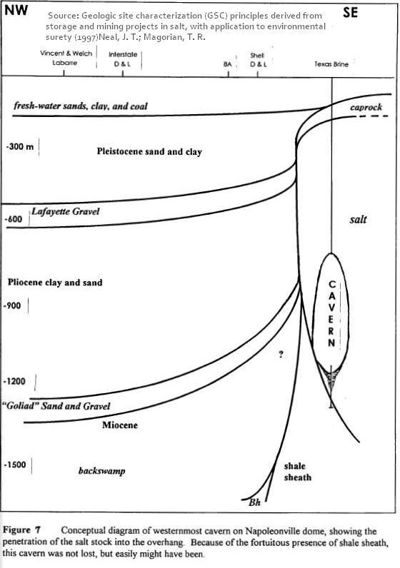
It turns out that the article cited in post #138 is available for public distribution. There isn't much more detail about what happened, but the diagram indicates that it was a Texas Brine cavern:

cavernsketch1997a.jpg


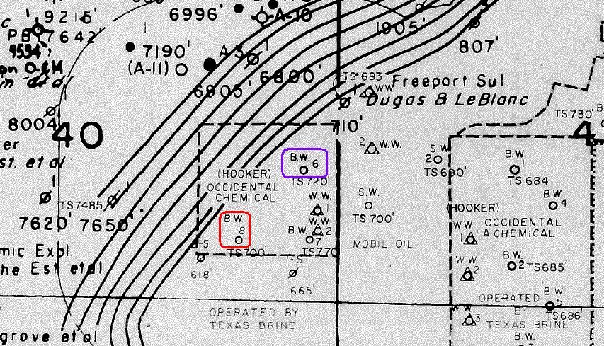
Here's a dome map. I think the currently collapsing Oxy3 is the one I circled in red, and Oxy1 is the one I circled in purple:
(Hooker 6,7,8 got renamed to Vulcan 1,2,3 at some point...which is also called Oxy 1,2,3 now, I'm assuming)

wellmap.jpg

(Source for above map: http://ucmwww.dnr.state.la.us/ucmsearch/UCMRedir.aspx?url=http%3a%2f%2fdnrucm%2fucm%2fgroups%2fconservation%2fdocuments%2fooc%2f4282885.pdf. Hat tip to Freedomrox for pointing this out.)

Oxy3 is the westernmost brine well (BW) on the dome at the point that map was made, but in 1987 on page 33 in this document, Texas Brine says Hooker 6 was the only well in that westernmost area that had encountered an 'anomaly' - shale. (There is more on that on page 75.)

That doesn't agree with the 1997 article by Sandia scientists, since Hooker 6 is a little east of Hooker 8, (a.k.a. Vulcan/Oxy3). So I'm still unsure about which of those two caverns had some sort of incident prior to 1997. :confused:
 
Re: Louisiana: Assumption Parish Bayou Corne Sinkhole 2012

Re: Louisiana: Assumption Parish Bayou Corne Sinkhole 2012

Good find, Emily :tiphat:

The cavern in figure 7 sure looks like the current collapsing cavern. If so, then what happened to the shale sheath that prevented past problems?

The helicorders are really active at this time. Texas Brine was ordered to put the helis online, which they did; now they are back down to only 6 online for La. It would be great if we had some sort of situation update when we see action like what's happening today. Maybe they have already started with the vibrating equipment mentioned below?

Heli 14.webp
http://folkworm.ceri.memphis.edu/heli_temp/
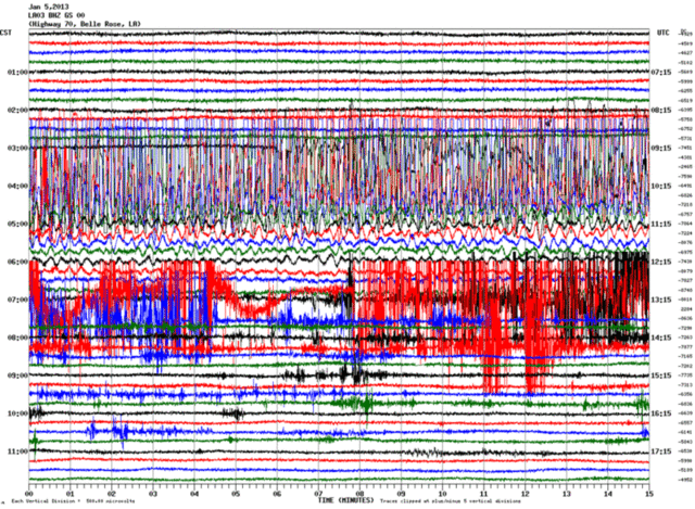
There was a meeting yesterday but nothing has been posted yet at the parish site. However, the news covered it. It appears that the residents are understandably losing patience.

Regarding 3d seismic monitoring:
Bayou Corne residents can expect to see vibrator trucks and air guns (equipment attached to flat bottom boats) in the area. Workers will use them to send vibrations in to the ground that will be picked up on measuring equipment around the area. Officials said it will take until at least mid April to wrap up testing.
http://www.nbc33tv.com/node/39541
 
Re: Louisiana: Assumption Parish Bayou Corne Sinkhole 2012

Re: Louisiana: Assumption Parish Bayou Corne Sinkhole 2012

Emily, and friends,

I just want to say I am so proud of your efforts and research skills. It blew me away how on top of this you have been, and that's saying something when I write a blog about it.

I believe I can answer your questions about Hooker #6, Oxy #1. Back in 1987Texas Brine sought to expand the solution mined cavern for larger storage capacity, but failed. They went down to 3000 ft. approximately, and hit shale rock. They then plugged off and cemented the bottom and proceeded to brine the cavern outwards more towards the top. This is the most deformed and shallowest of caverns as shown by the 1993 SONAR survey.

http://ucmwww.dnr.state.la.us/ucmse...groups/conservation/documents/ooc/4436906.pdf

As for the 1997 paper, this speaks of Oxy 3, as is shown by coordinates of it being the westernmost cavern in the Salt Dome. The last 500 ft. at the time, showed the straight line deformation of where the cavern had been miscalculated and was now resting upon the shale sheath, which is all that held containment at the time.

SONAR Survey and VSP shown at my blog.
http://freedomrox.wordpress.com/201...nd-texas-brine-knew-oxy-3-could-fail-in-2010/

What was not taken into account was two-fold, first they did not take into account the effects of drawdowns, as this would widen the area against the sheath that was bereft of salt. This finally left about the deepest 1000 ft. (4500-5500 ft.) of the cavern and the contents and pressures sitting on the actual shale sheath itself from the inside.

The second thing not taken into consideration was that salt creeps. When a cavern is filled it is under pressure, plus the weight of the overburden, and when it is drawndown then the salt creeps back in with the difference in temps and pressures. In a very real way, it can be stated a salt cavern functions similar to a lung. This is due to the plasticity of salt rock. Shale has no such elasticity. It can only take so much in the way of pressure, and then it fractures.

Now, add to this that Big Hum, Marg Vag and all the oil and gas and water formation sands were pressing from the outside of the Salt Dome and pinching up against the very same shale sheath that was dealing with the cavern pressures in almost the exact same spots but from opposing sides. When this shale sheath finally fractured, it was a mighty geologic explosion 4500-5500 ft. down. Enough of one to fracture the shale and other materials all the way to the surface.

Every bit of this was known by LDNR and Texas Brine long before the mill out that failed the MIT test, and they Plugged and Abandoned Oxy #3. If they had drawndown the cavern one last time and Cemented the bottom 1000 ft.. then pumped back the brine and P&A'd the cavern, then this probably would not have ever happened. Due to the costs, they chose not to. LDNR knew this as well, even about the oil sands pressing against the shale sheath and cavern, due to their accessibility to Golden Gate's proprietary 3-D 2007 survey, that no one else has been allowed to see.

I wonder what Texas Brine thinks about the cost of that cementing job now?
:oops:
 
Last edited:
Re: Louisiana: Assumption Parish Bayou Corne Sinkhole 2012

Re: Louisiana: Assumption Parish Bayou Corne Sinkhole 2012

Welcome to FluTrackers, freedomrox. Thanks for your positive comments and information.
<object style="position:absolute;z-index:1000" type="application/x-dgnria" id="plugin0" height="0" width="0">

</object>
 
Re: Louisiana: Assumption Parish Bayou Corne Sinkhole 2012

Re: Louisiana: Assumption Parish Bayou Corne Sinkhole 2012

Thank you for allowing me to answer Emily, and proud to be here, Laidback Al. A wealth of information on this site.
 
Re: Louisiana: Assumption Parish Bayou Corne Sinkhole 2012

Re: Louisiana: Assumption Parish Bayou Corne Sinkhole 2012

Welcome to Flutrackers, freedomrox! :) Thanks very much for the background about the caverns - that explains why TB was milling upwards
from the top of Oxy3 back in 2010. That was a big mystery to me, since I got the impression, (could be wrong), that current convention was to mill from the top down. But if the bottom of the cavern had already been mined through to shale by 1997, then they couldn't mine in that direction. Given that the 1997 diagram shows the cavern right up against the edge of the dome, maybe the cavern should have been plugged at that point, and never re-worked. (If only...)

That is very interesting about the possibility of filling the bottom of the cavern with cement. It does sound like it would have been expensive, but as you point out, look at the expenses incurred from this unprecedented geological disaster. There's the new road, the berm, all the thumping and drilling, and now the 2-month 3D seismic survey. (Like the one Golden Gate did on the north side of the dome in 2007?) Then there is the 6 month long (and counting) evacuation costs and the human toll from that.

I read about the T-Rex studying the area on your blog and in the local papers. There's a good document with photos on that equipment here:
http://esg.eri.ucsb.edu/sites/esg.eri.ucsb.edu/files/Nigbor_NEES@UTexas.pdf

It seems to travel all over the country studying high risk earthquake areas like Seattle, New Madrid, etc. I hope all the studies and new vents have positive results - soon!
 
Re: Louisiana: Assumption Parish Bayou Corne Sinkhole 2012

Re: Louisiana: Assumption Parish Bayou Corne Sinkhole 2012

Good find, Emily :tiphat:

The cavern in figure 7 sure looks like the current collapsing cavern. If so, then what happened to the shale sheath that prevented past problems?

The helicorders are really active at this time. Texas Brine was ordered to put the helis online, which they did; now they are back down to only 6 online for La. It would be great if we had some sort of situation update when we see action like what's happening today. Maybe they have already started with the vibrating equipment mentioned below?

View attachment 15898
http://folkworm.ceri.memphis.edu/heli_temp/
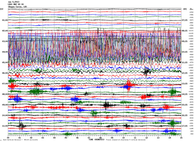
There was a meeting yesterday but nothing has been posted yet at the parish site. However, the news covered it. It appears that the residents are understandably losing patience.

Regarding 3d seismic monitoring:
http://www.nbc33tv.com/node/39541


The credit will have to go to Sandia for having these documents available. :tiphat: They will email you the articles you request from this list:

https://ugsprtech.sandia.gov/Pag_Reports/Bibliographies.aspx?c=2,4&g=Geotechnical

Thanks for sharing that unusual seismic pattern. It sure does look like something generated by research equipment. People are understandably worried about all the tests causing structural damage. I've never heard of anything like that happening, but it would be good to know there was insurance held to cover all possibilities.
 
Re: Louisiana: Assumption Parish Bayou Corne Sinkhole 2012

Re: Louisiana: Assumption Parish Bayou Corne Sinkhole 2012

What happened at the meeting was a joke. All brand new players, and a one Mr. "X" that kept brow-beating the audience with how he had left Brazil to come up here. He also stated he was a part of the Golden Gate proprietary survey in 2007, and that he was getting a tiny portion of that survey of the westernmost side to compare with the new VSP and 3 D survey to take place sometime this month. One more very interesting thing he did reveal was that they could not perform the 3 D surveys any further east around the other caverns due to the Danger of disturbing them.

I can provide the videos if you need them. Also the USGS heli's are gone. They have now been totally replaced with the geophones and are much more sensitive. Also, the Texas Brine Geo 3 in the 1000 ft. borehole they have been drilling should be online soon. Dr. Stephen Horton has sounded the alarm that much more seismic activity is taking place, signaling what I believe to be a continuation of the last event.

http://assumptionla.wordpress.com/

One question. Which one of the documents did you request to get the 1997 graphic, please? I would like to insert it into one of my articles.

All appreciation to you 'mixin' and others for your investigative skills.
 
Last edited by a moderator:
Re: Louisiana: Assumption Parish Bayou Corne Sinkhole 2012

Re: Louisiana: Assumption Parish Bayou Corne Sinkhole 2012

From today's parish update:
It has been reported to us, by Dr. Steve Horton, that there has been an above normal recording of seismic activity within the last few days. Should additional details or information regarding this situation become available, they will be posted.
http://assumptionla.wordpress.com/2013/02/04/1115-a-m-increased-seismic-activity/

Texas Brine also has a recent update:
1. The sinkhole has remained stable since Jan. 19, when vegetative material
rose to the surface and a small area sloughed in on the southern perimeter.
The vegetative material was corralled on the southeastern edge of the
sinkhole and is expected to be removed this coming week. No other changes
to the size or shape of the sinkhole have been observed.
2. Rehabilitation and elevation of the first segment of the access road that runs
southward from Hwy. 70 along the western side of the pipeline right-of-way
has been completed. A total of approximately 35,000 cubic yards of fill dirt
were added to raise the road elevation and also create a drill pad for a 1,000-
foot deep geophone well. Following the installation of the mat to support
the drilling rig, the first casing was driven, the rig was assembled and
drilling began early Sunday morning .
3. Construction of the square-shaped containment berm surrounding the
sinkhole has begun. Work on the southern segment is underway and
stretches from the Texas Brine site, westward across the pipeline right-of-
way to the southern end of the access road off of Hwy. 70. This road will
continue to be upgraded southward from the 1,000-foot deep geophone well
and will serve as the western boundary of the containment system. Texas
Brine?s facility site will provide containment on the eastern boundary. The
northern boundary, when complete, will connect the Texas Brine entrance
road to the access road nearer to Hwy. 70.
4. Two additional relief wells have been installed on the Texas Brine site. This
brings the total relief well count on the site to four. The first relief well,
installed in late October, continues to flare natural gas at the surface. The
other three are being prepared to start flaring next week.
Two new relief wells have been installed off site: one on the access road
near the intersection with Hwy. 70, and another on the northern side of
Hwy.70 west of the rig road entrance.
Seven additional relief wells will be installed in the area to complete Phase
II. Installation of those wells is targeted for completion by mid-February.
An additional ten (10) relief wells will be installed for Phase III as access to
properties becomes available.
5. The 3D seismic project is progressing. Project design is complete. Efforts
now are concentrated on surveying and on landowner access and permitting.
Representatives of the 3D seismic contractor are working to secure
permission from Bayou Corne homeowners to place seismic geophones on
their property. The placement of the geophones in the Bayou Corne
community, as well as all other receiver points in the project design area, is
important to the acquisition of sufficient data to generate as clear an image
as possible of the subsurface geologic conditions to a depth of 7,000 feet.
6. The passive seismic monitoring system that will replace the USGS
geophones currently in use is nearing completion. The system will be
comprised of a 480-foot deep geophone array, individual geophones placed
in six, 80-foot deep cased wells and a geophone array placed in Well #1, and
the final component, a geophone array placed in the 1000-foot deep well
being drilled adjacent to the access road west of the Texas Brine site. The
entire system is expected to be in place by mid-February. The seismic data
collected by all of the geophones in this passive system will be directed to
the same repository for analysis.
7. After being closed in for the past two weeks, the Observation Well was
opened Thursday in attempt to remove any liquid hydrocarbon remaining in
cavern #3. That process yielded no liquid hydrocarbon. The most recent
logging of the cavern indicated that floor had risen 100 feet since last
measured on Jan. 18.
8. To date, 23 pairs of LEL and H2S indoor monitors have been installed in 16
qualifying structures in the Bayou Corne community. By the middle of next
week, an additional 22 monitors are to be installed in14 other structures..
The monitors are designed to detect both the Lower Explosive Limit (LEL)
and hydrogen sulfide gas if any were to migrate into enclosed spaces in slab-
on-grade homes and structures as well as unvented spaces beneath raised
dwellings and structures. If either is detected at the preset alarm levels (10%
for LEL and 10 ppm for hydrogen sulfide) the monitor alarm will be
triggered and a signal will be transmitted to local emergency responders. To
assure transmission signal strength, a series of outside antennas have been
installed at carefully chosen locations throughout the Bayou Corne
community. To date, after over 90 indoor air sampling events by DEQ and
Texas Brine contractors, no detectable levels of LEL or hydrogen sulfide
have been found.
http://www.texasbrine.com/response/2013-02-03_TBC-Update.pdf
 
Re: Louisiana: Assumption Parish Bayou Corne Sinkhole 2012

Re: Louisiana: Assumption Parish Bayou Corne Sinkhole 2012

Thanks for the kind words, Freedomrox... and welcome to the forum.

I thought when they brought the internationally-recognized group, Itasca, to try to get some answers to the unknowns that we would finally get some good info on what's happening. Was any mention made of them in this last meeting?
 
Re: Louisiana: Assumption Parish Bayou Corne Sinkhole 2012

Re: Louisiana: Assumption Parish Bayou Corne Sinkhole 2012

Actually no mention was made of them at all.

From here you can see the presentation itself. Another meeting is supposed to be held on February 6th, if it hasn't been changed.

<iframe width="560" height="315" src="http://www.youtube.com/embed/_C4v37mZFZU" frameborder="0" allowfullscreen></iframe>
 
Last edited by a moderator:
Re: Louisiana: Assumption Parish Bayou Corne Sinkhole 2012

Re: Louisiana: Assumption Parish Bayou Corne Sinkhole 2012

One question. Which one of the documents did you request to get the 1997 graphic, please? I would like to insert it into one of my articles.

Here's the one that the diagram of Oxy3 is in, freedomrox:

Neal, J. T. and T.R. Magorian. April 1995. Geologic Site Characterization (GSC) Principles Derived from Storage and Mining Projects in Salt, With Application to Environmental Surety. SAND95-2400J. Sandia National Laboratories, Albuquerque, NM.


Once again, all the credit goes to Neal and Magorian, (and Sandia for having that Unlimited Distribution.)

Thanks for sharing insights about the latest briefing and the video links. :)
 
Re: Louisiana: Assumption Parish Bayou Corne Sinkhole 2012

Re: Louisiana: Assumption Parish Bayou Corne Sinkhole 2012

It just hit me Emily.... This paper was published in April 1995. So, they knew then or even 1994.
 
Re: Louisiana: Assumption Parish Bayou Corne Sinkhole 2012

Re: Louisiana: Assumption Parish Bayou Corne Sinkhole 2012

It just hit me Emily.... This paper was published in April 1995. So, they knew then or even 1994.

Good catch, freedomrox! One of the journals had published it in 1997, but looking at that again, it had been accepted in 1995, same date as in the Sandia reference, so the cavern trouble was indeed known a few years earlier than 1997.

Here's some new articles on developments in the sinkhole story.


Advocate: Residents - Insurance policies canceled

Insurance is great until you need it...


This is an article on the meeting tonight with politicians. :(

Advocate: Meeting gets contentious

It also has news about technical issues. The Shaw consulting group is recommending putting vent wells right in residential yards, but residents are hoping placement in the swamp or on the edges of residential areas might be adequate.

There's another scientist introduced who's going to give an independent opinion about the results of the 3D seismic survey for the state. This will be in addition to the opinion of the consultant hired by Texas Brine.

No mention of what happened to Itasca, mixin, but here is the Advocate article that reported about how their assessment about the cavern collapse differed from the first theory:
http://theadvocate.com/news/ascension/4718520-123/monitoring-projections-of-sinkhole-draw
BY DAVID J. MITCHELL
River Parishes bureau
December 26, 2012
[snip]
Hecox later said that Pettitt?s work has shown that part of the running theory on the formation of the sinkhole is likely incorrect.

Hecox and other scientists had initially theorized that the cavern had a ?frack out? of brine that happened almost immediately before the sinkhole?s formation.

He told residents Tuesday that Itasca has persuaded him that the formation of the collapse zone leading to the sinkhole occurred through a slow-moving fracture of the sedimentary rocks along the salt dome during a several-month span.

Hecox said the tremors residents had been feeling in the months before the sinkhole?s emergence were likely part of this process...

That would tie some of the damages to homes in the area and the bubbling prior, (ignored by both TB and LDNR), directly to the cavern collapse, I think. I hope they are still involved with the analysis...
 
Back
Top Bottom