• FluTrackers.com Inc. does not provide medical advice. Information on this web site is collected from various internet resources, and the FluTrackers board of directors makes no warranty to the safety, efficacy, correctness or completeness of the information posted on this site by any author or poster. The information collated here is for instructional and/or discussion purposes only and is NOT intended to diagnose or treat any disease, illness, or other medical condition. Every individual reader or poster should seek advice from their personal physician/healthcare practitioner before considering or using any interventions that are discussed on this website. By continuing to access this website you agree to consult your personal physican before using any interventions posted on this website, and you agree to hold harmless FluTrackers.com Inc., the board of directors, the members, and all authors and posters for any effects from use of any medication, supplement, vitamin or other substance, device, intervention, etc. mentioned in posts on this website, or other internet venues referenced in posts on this website.
  • We are not asking for any donations. Do not donate to any entity who says they are raising funds for us.

Louisiana: Assumption Parish Bayou Corne Sinkhole 2012-2015

Re: Louisiana: Assumption Parish Bayou Corne Sinkhole 2012

Re: Louisiana: Assumption Parish Bayou Corne Sinkhole 2012

Here is the latest map showing the new bubble sites on the left side and the other sites on the right side of the map. (I added the arrows). It's worrisome that bubbling has spread that far west, if it's from the same source as the rest of the sites.

Thanks, mixin. I didn't realize how far the bubbles had spread. That map makes it very clear. There's another good map that the OpEdNews author modified to highlight the growth of the sinkhole here:

http://www.opednews.com/articles/Mysterious-Bayou-Sinkhole-by-Meryl-Ann-Butler-120929-961.html

The Examiner has an article about some news shared at meeting on the situation.

http://www.examiner.com/article/hydrocarbons-breaching-sinkhole-cavern-bottom-oil-75-atop-hole

It sounds like the bottom of the cavern has been breached by hydrocarbons of some sort. It might be oil. The cavern seems a long way from finding equilibrium.

The Parish posted a video of clean-up efforts at the sinkhole. As the camera pans away from the working equipment to survey the vast contamination of the site, it's just overwhelming. I hope the workers have proper respirators and life jackets on at all times.

<object width="560" height="315"><param name="movie" value="http://www.youtube.com/v/2pcLQhfyLkY?version=3&hl=en_US"></param><param name="allowFullScreen" value="true"></param><param name="allowscriptaccess" value="always"></param><embed src="http://www.youtube.com/v/2pcLQhfyLkY?version=3&hl=en_US" type="application/x-shockwave-flash" width="560" height="315" allowscriptaccess="always" allowfullscreen="true"></embed></object>
 
Last edited:
Re: Louisiana: Assumption Parish Bayou Corne Sinkhole 2012

Re: Louisiana: Assumption Parish Bayou Corne Sinkhole 2012

The videos of the residents' meeting last Saturday is at YouTube. They broke it down into 23 parts so each one is about 4 minutes long.

http://www.youtube.com/user/assumptionla

I took some notes from the first 9 videos, the first 2 were mostly updates that we've already heard. Then came Brian Davis from Shaw talking about the cavern findings.

They used sonar to examine the walls, pinging every 3? all around the cavern at multiple depths. Whatever is in the bottom of the cavern is solid and the sonar weight would not penetrate it. So the sonar could not ping the area of solid material (1600 ft.). Davis said the area from 4000 ft. up to the top of the cavern is very similar to the last sonar taken in 2007. He concluded the breach was somewhere in the area of the solid material.

In vid #5, there was a slightly heated discussion between one of the residents and the officials. The resident asked (but didn't state it clearly enough) how the top protective layer of diesel escaped from the cavern into the sinkhole if the top wasn't compromised. After some confusion regarding the question was cleared up, Davis finally admitted in vid #7 they did not know the answer to that question.

In video #9, a resident also asked about the possibility of another cavern collapse and what they would do about it. Steven Chustz, from the DNR, said they are looking at monitoring all of the caverns in the dome.

They give the residents a lot of info about what is currently being done but very little regarding the "what ifs".

They also uploaded some new flyover vids at that same link. The cleanup of the sinkhole has resumed and it looks a lot better. It has done some serious spotty expansion, shown in the second screen cap.

Sinkhole Flyover a 10.4.12.webp

Sinkhole Flyover b 10.4.12.webp
 
Re: Louisiana: Assumption Parish Bayou Corne Sinkhole 2012

Re: Louisiana: Assumption Parish Bayou Corne Sinkhole 2012

Thanks very much for taking the time to review the videos, mixin! I looked at the cavern sketch you posted here, and if I am reading things right, they think the bottom 2/3's of the cavern is badly compromised.

I'm surprised they don't know what that dense material is at the bottom of the cavern. How many possibilities could there be? Wonder why the ROV has not been sent in:

http://ieeexplore.ieee.org/xpl/login.jsp?tp=&arnumber=726339&url=http%3A%2F%2Fieeexplore.ieee.org%2Fxpls%2Fabs_all.jsp%3Farnumber%3D726339
A specialized ROV for inspection of salt dome caverns
Abstract

An underwater remotely operated vehicle was designed to enter a solution-mined cavern in the Clovelly salt dome in southern Louisiana to survey the condition of its interior, take core samples, and restore its structural integrity using a new gel technology. Preliminary experiments were conducted to determine the operating environment inside the cavern. The resulting vehicle system was deployed inside the cavern, and completed the first phase of operations, including survey, sample collection, and distribution of gel.

Maybe this one is already too far gone to fix now, but they could at least find out what kind of rocks are in there.

Apparently a 'controlled collapse' was used once to deal with a whole solution mined field that went awry in Romania. (They decided to close the entire field down for the sake of nearby residents' safety):

http://www.springerlink.com/content/5766716138727x2t/
Microseismic Monitoring of a Controlled Collapse in Field II at Ocnele Mari, Romania
C-I. Trifu and V. Shumila

Abstract
Several decades of faulty exploitation of salt through solution mining led to the creation of an underground cavern containing several million cubic meters of brine. To eliminate the huge hazard near a densely inhabited area, a technical solution was implemented to resolve this instability concern through the controlled collapse of the roof while pumping the brine out and filling the cavern with sterile. To supervise this, an area of over 1 km2 was monitored with a staggered array of 36 one-component, 15 Hz geophones installed in 12 boreholes about 160?360 m deep. A total of 2,392 seismic events with M w −2.6 to 0.2 occurred from July 2005 to March 2006, located within an average accuracy of 18 m. The b-value of the frequency-magnitude distribution exhibited a time variation from 0.5 to 1 and from there to 1.5, suggesting that the collapse initiated as a linear fracture pattern, followed by shear planar fragmentations and finally a 3-D failure process. The brunching ratio of seismicity is indicative of a super-critical process, except for a short period in mid-February when temporary stability existed. Event relocation through the use of a collapsing technique outlines that major clusters of seismicity were associated with the main cavern collapse, whereas smaller clusters were generated by the fracturing of smaller size nearby caverns...

When you get a bunch of these caverns in close proximity to each other, they essentially become a system like one big underground pillar and room salt mine, with the unmined land between the caverns acting as the pillars holding the entire overburden up. When the virtual pillars collapse in such a system, several caverns form one massive one then.
 
Re: Louisiana: Assumption Parish Bayou Corne Sinkhole 2012

Re: Louisiana: Assumption Parish Bayou Corne Sinkhole 2012

Emily,
they think the bottom 2/3's of the cavern is badly compromised.
I agree with your comment based on the measurements we have; but Davis said the top 2/3 was not compromised. However, he's only been involved for a couple of weeks, so maybe he just got it a little backwards.

The residents are asking good, straight-up questions that deserve answers. One asked about a possibility of something happening (I couldn't understand the question, something about gas venting) and Chustz avoided answering. There was a bit of heated exchange and Chustz came back to the podium and answered: yes, there is the possibility but we are going to do it safely so it doesn't. Another question was what gas pressure they had in mind and they got no answer, until they absolutely pushed the issue. I guess the officials forget that a few residents remember the Gulf South incident.

I didn't know they had ROVs for salt domes; how big are they? If I'm understanding the diagram of the cavern roof, the only opening in the top of it is the 6 1/8" borehole.

Golden Gate Petroleum has an oil/gas well interest in this salt dome. Here is a 2010 article, detailing their project and containing this map. I wish I could find the original map; it's hard to tell what sands are up against the dome where the cavern is.

I find no mention of that gas/oil drilling in the area; I wonder if the officials have ruled those out as possibilities for the gas leaks. If they have indeed been monitoring all of the brine/storage caverns, they would surely know if one of the storage wells was leaking. Chustz replied to to a cavern monitoring question but he didn't give any results of that monitoring.


Salt Dome Marg Vag.webp
 
Re: Louisiana: Assumption Parish Bayou Corne Sinkhole 2012

Re: Louisiana: Assumption Parish Bayou Corne Sinkhole 2012

I didn't know they had ROVs for salt domes; how big are they? If I'm understanding the diagram of the cavern roof, the only opening in the top of it is the 6 1/8" borehole.

There are few details available about that salt cavern ROV, but I can't imagine it being small enough to fit through a pipe that size. I wonder about exploring the sinkhole for access to the cavern with an ROV? In the latest Texas Brine update, the substance at the bottom of the cavern is being described as a 'sediment' so I wonder did some cavern brine and diesel exchange places with the missing matter in the sinkhole? But most likely any channels are closed by now if that did happen, I suppose.

Whatever it is, the parish says that Texas Brine is running a 'wire line' to sample it now. Also the parish says the fingerprinting of the cavern gas should be done next week. That could solve a big mystery if all the bubble fingerprints match that.

I watched the last video in the meeting series, and an official at the end said that what is happening at the dome is complex and unprecedented in this country. They are aware of similar things happening in other countries, (maybe like the case in Romania), and it sounded like they are trying to get more information about those cases.

Here's the latest Advocate article about drilling to remove gas:

http://theadvocate.com/news/4070183-123/drilling-to-remove-gas-near
 
Re: Louisiana: Assumption Parish Bayou Corne Sinkhole 2012

Re: Louisiana: Assumption Parish Bayou Corne Sinkhole 2012

There are reports of tremors and explosive sounds in a couple more parishes in southern Louisiana:

http://www.examiner.com/article/mysterious-tremors-45-miles-from-sinkhole
Mysterious tremors 45 miles from sinkhole

top national news
October 5, 2012
By: Deborah Dupre


http://www.houmatoday.com/article/20121004/ARTICLES/121009798?tc=ar
Mysterious tremors raise questions
Xerxes A. Wilson
Staff Writer
Published: Thursday, October 4, 2012 at 9:59 p.m.
Last Modified: Thursday, October 4, 2012 at 9:59 p.m.

Nobody quite knows what caused the ground in some parts of Lafourche and Terrebonne parishes to shake, but it certainly has people talking...

Officials say it's not related to the Bayou Corne situation, but these are also salt dome areas with caverns, from what I understand, so people can't help but think of the Assumption Parish sinkhole.

You'll have to hit the '-' sign to see all the new points of interest:

  • A: Lockport, LA
  • B: Raceland, LA
  • C: Houma, LA
  • D: Pierre Part, LA (A few miles southwest of sinkhole where new bubbles and some tremors were reported recently, too,)
<iframe width="425" height="350" frameborder="0" scrolling="no" marginheight="0" marginwidth="0" src="http://maps.google.com/maps?f=d&source=s_d&saddr=Lockport,+LA&daddr=Raceland,+LA+70394+to:Houma,+LA+to:Pierre+Part,+LA&hl=en&geocode=Fd9cxAEdDHua-illtqj2cOMghjG6jd5wv7m65Q%3BFcmaxQEdwJGZ-imF5p2q4OEghjF2bRngaV2jqg%3BFXqYwwEd0bqX-indH8ENwwQhhjFhcgx8c1hlNg%3BFZI7yQEdqVmQ-im5QoUkBlghhjEC_JbsvYiGoA&aq=0&oq=pie&sll=29.668963,-90.637207&sspn=2.529556,3.532104&gl=us&mra=ls&ie=UTF8&ll=29.7809,-90.878615&spn=0.37012,0.67873&t=m&output=embed"></iframe><br /><small><a href="http://maps.google.com/maps?f=d&source=embed&saddr=Lockport,+LA&daddr=Raceland,+LA+70394+to:Houma,+LA+to:Pierre+Part,+LA&hl=en&geocode=Fd9cxAEdDHua-illtqj2cOMghjG6jd5wv7m65Q%3BFcmaxQEdwJGZ-imF5p2q4OEghjF2bRngaV2jqg%3BFXqYwwEd0bqX-indH8ENwwQhhjFhcgx8c1hlNg%3BFZI7yQEdqVmQ-im5QoUkBlghhjEC_JbsvYiGoA&aq=0&oq=pie&sll=29.668963,-90.637207&sspn=2.529556,3.532104&gl=us&mra=ls&ie=UTF8&ll=29.7809,-90.878615&spn=0.37012,0.67873&t=m" style="color:#0000FF;text-align:left">View Larger Map</a></small>
 
Last edited:
Re: Louisiana: Assumption Parish Bayou Corne Sinkhole 2012

Re: Louisiana: Assumption Parish Bayou Corne Sinkhole 2012

This is getting so complicated we could subtitle this thread as: More than we ever thought we would know about salt domes. :D

In vid #19, one of the officials said the preliminary fingerprint results, aka isotope testing, had just come in. In his non-expert opinion, he thought the gas from the cavern and the gas from some of the bubble sites was very similar. He said the experts would look at them and hopefully they would know more "next week", which should have been this week. So we continue to wait...

One of the residents did ask about intentionally collapsing the failed cavern and Davis laughingly said he hoped he was back in Texas if they tried something like that.

They reassured residents that there was nothing dangerous health-wise in the air samples and the smell from the diesel was very unpleasant but compared it to the health risks of smelling a dead skunk.

The resident asked about monitoring the elevations around Highway 70 and that expert said they were unchanged. Resident asked if they could use the 1960's as a benchmark, claiming he thought the road had sunk over the years. The highway info will be posted on the site.

*******************
Emily, your comments about the pillars added to my curiosity about the dome. Here is the link to the USGS report: SALT-DOME LOCATIONS IN THE GULF COASTAL PLAIN, SOUTH-CENTRAL UNITED STATES

Page 28 shows Napoleonville dome has a volume 7.7 cubic miles. I had intended to calculate how much salt had been mined; but then realized unless we know the depth of all of the caverns and the shape of the dome, it's kind of a moot point.
 
Re: Louisiana: Assumption Parish Bayou Corne Sinkhole 2012

Re: Louisiana: Assumption Parish Bayou Corne Sinkhole 2012

Gas trapped near sinkhole<!--/fi:/csp/mediapool/sites/Advocate/assets/csp/storyheadline.csp, e:.000473 --></HEADER><!--/fi:/csp/mediapool/sites/Advocate/assets/templates/common/Header.csp, e:.007148 -->
<!-- fi:/csp/mediapool/sites/Advocate/assets/templates/common/Main.csp -->
By David J. Mitchell
River Parishes bureau
October 08, 2012

An as-yet undetermined amount of natural gas is trapped in the aquifer underneath the Bayou Corne community, state and parish officials have said.
...
John Boudreaux, director of the Assumption Parish Office of Homeland Security and Emergency Preparedness, said there are concerns the gas can build up pressure under the clay layer that lies above the aquifer.

Once the pressure in the aquifer reaches a pressure greater than 75 to 85 pounds per square inch, the clay layer might not be able to hold back the accumulated gas, according to Boudreaux and geologists.

?And then it could be a problem because you do not know where the weak point would be until after it has already done its thing,? Boudreaux said.

He said contractors started driving casing Saturday for three vent wells in Bayou Corne to get a better idea about what is happening underground, where the gas is located, so the gas can be vented off.
...

Full text:
http://theadvocate.com/home/4074852-125/gas-trapped-near-sinkhole
 
Re: Louisiana: Assumption Parish Bayou Corne Sinkhole 2012

Re: Louisiana: Assumption Parish Bayou Corne Sinkhole 2012

I assumed that everyone who was in an area that could be affected by fumes from the sinkhole were in the evacuation zone that could receive aid from Texas Brine to relocate, but that isn't true.

Family with 2 and 6 yr-old children suffering headaches, earaches, nausea and respiratory problems strongly correlated to air pollution from sinkhole that reaches their home 2 miles from the sinkhole when the wind is blowing in that direction:
http://www.examiner.com/article/gassed-louisiana-sinkhole-family-human-rights-plea-exposes-coverup

I think the evacuation zone should have included areas with children if they are being routinely exposed to fumes. It sounds like the family above is also near one of the newer bubbling sites in the Pierre Part area.

There is a petition to extend the evacuation zone online:

http://www.change.org/petitions/lou...ded-in-the-bayou-corne-grand-bayou-evacuation

They say they need more signatures.
 
Re: Louisiana: Assumption Parish Bayou Corne Sinkhole 2012

Re: Louisiana: Assumption Parish Bayou Corne Sinkhole 2012

The smell was brought up by a resident at the meeting. He said some people claimed their headaches and other sypmtoms went away after they were evacuated. They are being asked to contact the number on their site (health dept?) and give all of their symptoms.

Here are the recent updates at the Assumption Parish Blog

October 8, 2012 Regarding the Highway Survey:
The Location and Survey Section of DOTD has been conducting surveys along La. Hwy. 70 for the purpose of detecting any possible movement in the roadway. To date four surveys have been conducted on points that were set for this purpose. The resulting data from the four surveys has been entered into an automated spreadsheet that compares coordinate and elevation values of each survey to the first survey.

DOTD survey crews began preparations to conduct the surveys on 08-06-12 setting the control points necessary to conduct the surveys, establishing the coordinates and elevations of the control points and setting the points that would be monitored.

The first survey was completed on 08-15-12 which is the benchmark survey to which the subsequent surveys are being compared. The subsequent surveys were completed on 08-22-12, 09-19-12 and 09-25-12.

Additional surveys will be conducted and the resulting data will be compared to the benchmark survey data. (One of the residents asked them to go back to the 60's for the benchmark. One prior to the sinkhole forming would have been better than the 8-15 benchmark, IMO)

At this time, the data comparisons do not indicate to us that there is any detectable movement in the roadway. The small differences we see in the data appear to us to be normal survey error which is typical in survey measurements. We have made our survey data available to the scientific community for their assessment.

The survey data can be found here:
http://www.dotd.la.gov/administration/public_info/projects/bayoucorne/

*******************

October 9, 2012 8:45 a.m.
Driving of casing in the third vent well is complete, they were able to go down to 200′. We are advised to expect flaring by the weekend.

We have been advised that Texas Brine is continuing clean up at the sinkhole site.

The resident briefing will be held this evening at 6:00 p.m. at the Command Post.

********************

October 9, 2012 10:50 a.m.
There has been a 10′ x 50′ foot slough in of the sinkhole on the SW side (towards the pipeline right-of-way, the 50′ is along the embankment of the hole). Five trees were lost during this slough in. Clean up has been halted until further notice.

**************

From Texas Brine:
Texas Brine will have a representative at the community meeting scheduled
for 6:00 p.m. Tuesday, October 9th at the command center on Hwy. 70 at
Bayou Corne.
 
Last edited:
Re: Louisiana: Assumption Parish Bayou Corne Sinkhole 2012

Re: Louisiana: Assumption Parish Bayou Corne Sinkhole 2012

http://theadvocate.com/home/4097747-125/gas-found-in-aquifer-previously
Gas found in aquifer previously
By David J. Mitchell
River Parishes bureau
October 09, 2012

The latest release of natural gas discovered in an underground aquifer near Bayou Corne may be the third time in the past 13 years that gas has been loosed in shallow formations over or near the subterranean Napoleonville salt dome, according to a review of regulatory filings....

Another important revelation in the article is that DNR officials and the group of scientists working with them have not ruled out that gas from the 2003-04 Grand Bayou incident is still in the aquifer, contrary to the impression Gulf South had until this point in time.

Also I think this is the first article that brings up the possibility that leaking wells from oil and gas exploration in the dome vicinity may have contributed to the gas burden in the aquifer. I've been wondering about this after reading about that wild well incident in 2010. There was a relief well in progress at the time it stopped spewing on its own, and the operator got permission to divert the relief well into a production well. Looking at the diagram on page 16 below, it looks like the first well overshot the oil pocket.
http://www.docstoc.com/docs/123837983/This-presentation-contains-forward-looking-statements-that-are

When a blowout stops on its own, they assume either it spontaneously 'bridged' or the pressure was released from the pocket it hit.

To me, a 'bridged' well sounds very uncertain as to consequences. Did a collapse of the well bore underground just end up diverting the water and gas elsewhere? The well was eventually properly plugged at the surface, but the spontaneous bridge that actually stopped the blowout would be a plug wouldn't it, and possibly a poor plug?

http://www.npc.org/Prudent_Development-Topic_Papers/2-25_Well_Plugging_and_Abandonment_Paper.pdf
Working Document of the NPC North American Resource Development Study
Made Available September 15, 2011
[snip]
Unplugged or poorly plugged wells are an environmental hazard as they provide potential conduits for fluids to migrate between formations and potentially into the fresh water zones. Poorly plugged wells also might provide pathways for natural gas to seep to the surface and potentially cause fire or be a health hazards. An abandoned well?s potential for causing a
potential hazard is largely dependent on the original use of the well. Oil wells that have been pumped for years will typically be very low pressure and the risk of contamination is low while a gas well that is flowing at a rate that is non-economical can still posses enough pressure to be a risk to the environment...
 
Re: Louisiana: Assumption Parish Bayou Corne Sinkhole 2012

Re: Louisiana: Assumption Parish Bayou Corne Sinkhole 2012

Here are screen caps of the helicorder readings at #3 and #9. The first one is from midnight until noon today and the second is from noon to current. Notice how the increased activity begins around 7 am. The other 4 weren't as active as these 2.

This is #3

LA03 00 Oct 9.webp

LA03 12 Oct 9.webp


This is #9

LA09 00 Oct 9.webp

LA09 12 Oct 9.webp

Here's a map of the placements of the helicorders

Seismometer Map R.webp
 
Re: Louisiana: Assumption Parish Bayou Corne Sinkhole 2012

Re: Louisiana: Assumption Parish Bayou Corne Sinkhole 2012

Thanks, mixin! That's very interesting to see! The active locations look close to the sinkhole. Maybe this was involved in the latest collapse. Fortunately no workers were injured, but the last photo of the sinkhole I saw had shown great progress in cleanup. It even looked like all the debris had been removed so they could move on to dealing with the oil. Now they have more debris to pull out and operations had to stop again. :(

http://www.nola.com/environment/index.ssf/2012/10/sinkhole_cleanup_halted_as_mor.html
Assumption Parish sinkhole cleanup halted as more land consumed
The Associated Press By The Associated Press
on October 09, 2012 at 3:59 PM, updated October 09, 2012 at 4:21 PM
 
Re: Louisiana: Assumption Parish Bayou Corne Sinkhole 2012

Re: Louisiana: Assumption Parish Bayou Corne Sinkhole 2012

Just posted:
http://assumptionla.wordpress.com/

NEWS RELEASE
www.dnr.louisiana.gov
For Immediate Release
Tuesday, Oct. 9, 2012
Contact: Phyllis Darensbourg, 225.342.0058

Office of Conservation: Crude Oil Source May Link Sinkhole and Failed Texas Brine Cavern.
Analysis indicates sinkhole ?diesel slick? and liquid hydrocarbon found in cavern samples are likely raw crude oil from same source

BATON ROUGE ? Louisiana Commissioner of Conservation James Welsh said today that detailed, comparative analysis has revealed that the liquid hydrocarbon from the failed Texas Brine cavern and samples from the nearby sinkhole/slurry area strongly indicate that both are naturally occurring crude oil and not diesel ? likely from the same underground source.

Experts theorized that early analysis of the substance coating the surface of the sinkhole/slurry area showed it could be a ?diesel-range? hydrocarbon ? meaning it contains some of the same hydrocarbons as refined diesel fuel; however, that classification has now been ruled out.

Welsh said that early analysis was primarily aimed at establishing potential toxic effects, and used the term ?diesel-range? as a rough classification, with further analysis needed to determine the nature of the substance more precisely.

?Distinguishing between ?diesel fuel? and ?diesel-range crude oil? is critical to the effort to ensure public safety by determining the cause of the cavern failure and the sinkhole, and their possible link to each other and to the natural gas that has been found in the aquifer in the Bayou Corne area,? Welsh said. ?While our ongoing review of operational records on the Napoleonville Salt Dome has not shown one single underground source known to contain enough diesel fuel to cover the sinkhole/slurry area, an underground oil-and-gas formation could easily account for the amounts found on the sinkhole/slurry area surface and in the cavern.?

Welsh said that better understanding of the source of the crude oil could also help better identify the source of the natural gas in the aquifer because oil and natural gas are often found together in productive formations.

Additionally, he noted that ongoing ?fingerprint? analysis of natural gas samples from Bayou Corne-area bubbling sites has now ruled out the nearby Crosstex butane storage caverns and Acadian natural gas storage caverns as potential sources of the natural gas bubbling.

Welsh also said that as analysis of the failed cavern and sinkhole is ongoing, work has progressed on construction of the vent wells ? with initial flaring of natural gas expected to begin by Friday.

?We discovered natural gas in both wells sites near the sinkhole and are now working as quickly as possible to remove it through these vent wells,? Welsh said. ?However, the initial analysis of the third well, sited on the west side of Bayou Corne, reveals that it does not have an accumulation of natural gas, though analysis will continue at that well as the work continues throughout the area to resolve the situation for the community.?

Patrick Courreges
Department of Natural Resources
225-454-8223
assumptionla | October 10, 2012 at 6:35 am | Categories: Uncategorized | URL: http://wp.me/p2Ed3J-eN
 
Re: Louisiana: Assumption Parish Bayou Corne Sinkhole 2012

Re: Louisiana: Assumption Parish Bayou Corne Sinkhole 2012

Some highpoints from the meeting yesterday:
http://assumptionla.wordpress.com/

* Hydrocarbon from the failed Texas Brine cavern and samples taken from the sinkhole strongly indicate that both are naturally occuring crude oil (not diesel) and likely coming from same underground source
* Analysis of the failed cavern and the sinkhole are ongoing
* Flaring of the vent wells on Highway 70 are expected to begin flaring on Friday
* Results of Isotopic samples taken from bubbling discovered on private property on Bayou Drive in Pierre Part have been determined to be swamp gas and not natural gas. Results show that the bubbling is not associated with this incident

********************
Texas Brine has provided profiles of the sinkhole. The deepest point is 449'.

Sinkhole Profile 9.10.webp

You can find that at the Assumption Parish site


or at this direct link

*************

Also released at the DNR site are 2 very informative docs:

Direct links:
-Current Status of Cavern Operations
-Precision Level Surveys & Subsidence Analysis
 
Re: Louisiana: Assumption Parish Bayou Corne Sinkhole 2012

Re: Louisiana: Assumption Parish Bayou Corne Sinkhole 2012

Thanks for posting the sinkhole profile, mixin! It's amazing how jagged it is. The parish site says a big section of Acadian Gas's pipeline just popped to the surface there today. It had been emptied so the concern would be for cleanup workers as far as a collision. They are using an airboat to push debris to the long-reaching crane for removal. Also it sounds like they are back at work in sinkhole today already.

The parish also reported that LA 70 was closed again after a startling flare from the Crosstex site. That was determined later to be within normal operating parameters, but just very large.

The Advocate has an extensive article covering some of the points in your post. They discuss the mystery of the material in the bottom of the cavern:

http://theadvocate.com/news/4121479-123/expert-links-gas-sinkhole
Expert links gas, sinkhole
Geologist: Connection seen in info

By David J. Mitchell
River Parishes bureau
October 11, 2012
[snip]
Material believed to be a shale sediment was found inside the plugged and abandoned Texas Brine salt cavern, apparently filling about 1,500 feet of the 2,250-foot-long cavity and pointing to some kind of cavern failure along its lower side.

I haven't been able to find another case exactly like this where the side of a cavern collapsed. I saw a report about a 'salt fall' in an SPR cavern, but they are saying this is shale, not salt. That's confusing since you'd think the walls of a salt cavern would be made of salt, but maybe the shale is indicative of the 'breach' that was suspected in 2011, and concern that the salt dome boundary was closer to the well than originally thought.
 
Re: Louisiana: Assumption Parish Bayou Corne Sinkhole 2012

Re: Louisiana: Assumption Parish Bayou Corne Sinkhole 2012

I started listening to the meeting videos but got sidetracked at #3. Texas Brine sent a rep and he talked for about 10 minutes. He said the sediment is a dark gray shale-type material, which almost gives the appearance of wet cement.

New findings were posted last night in a 4 page PDF (which won't allow copying) so I made this brief summary of the important points.

* it's believed that there is a side breach and a side wall collapse in the cavern
* it now contains 3.3 million cubic yards of material and 700,000 cubic yards of brine
* based on the location of the sinkhole, the movement of the material from the outside of the cavern into the cavern likely followed the edge of the salt from the cavern to the surface, resulting in the sinkhole
* the volume of the sinkhole is 550,000 cubic yards.
* it has to be assumed that the collapse zone is currently unstable
* the gas has all of the characteristics of natural gas
* based on chromatograms, the hydrocarbon liquid from the sinkhole surface has the same characteristics as the cavern, except for the absence of light-end hydrocarbons which is typical when exposed to surface environment.
* eliminated as probable sources: Chevron, Acadian, Crosstex and residual gas from the 2003 Gulf South blowout.
* remaining probable source: Big Hum, Marg A, Cris R, and Marg Vag production zones
* current data indicates the failure of the Texas Brine cavern provided an upward path of migration for crude oil & natural gas previously confined to a naturally occurring formation, allowing accumulation of NG in the alluvial aquifer and causing the bubbling sites.
* ~10 ft of gas accumulation has been found near the TB core-hole and ~ 5 ft accumulation has been detected NW of the Oxy 3 facility and the sinkhole. Additional gas or crude oil migration is possible.
* TB given 8 measures to undertake regarding upgrades, installations, etc. and failure to comply may result in civil penalties.

Direct link
http://dnr.louisiana.gov/assets/OC/BC_All_Updates/12.OC.OCTORDER.pdf
 
Re: Louisiana: Assumption Parish Bayou Corne Sinkhole 2012

Re: Louisiana: Assumption Parish Bayou Corne Sinkhole 2012

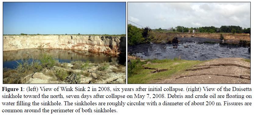
The Daisetta, (photo on the right), sinkhole is so far the only one I could find that had crude oil and debris on top of it like the one at Bayou Corne. Daisetta is in a shallow salt dome in east Texas so somewhat similar geology to the Napoleonville dome. (That 'Wink Sink' area is in west Texas.)

http://www.beg.utexas.edu/staffinfo/paine-pubs/sageep2009_paine_sinkholes.pdf
Paine, J. G., Buckley, Sean, Collins, E. W., Wilson, C. R., Kress, Wade, 2009, Assessing sinkhole potential at Wink and Daisetta using gravity and radar interferometry: in Proceedings, 22nd Symposium on the Application of Geophysics to Engineering and Environmental Problems, Fort Worth, Texas, March 29?April 2, p. 480?488.
winksinkdaisettatexassinkholes.jpg

What might be different is the source of the crude. I have not seen that explained for the Daisetta sinkhole, and you can see storage tanks falling into the hole as it opened.
<object width="420" height="315"><param name="movie" value="http://www.youtube.com/v/cz-MajKq_XY?version=3&hl=en_US"></param><param name="allowFullScreen" value="true"></param><param name="allowscriptaccess" value="always"></param><embed src="http://www.youtube.com/v/cz-MajKq_XY?version=3&hl=en_US" type="application/x-shockwave-flash" width="420" height="315" allowscriptaccess="always" allowfullscreen="true"></embed></object>

Also I did not see anything about gas being released in Daisetta, though it sounds like injected waste was released.
http://www.chron.com/news/houston-texas/article/Daisetta-fears-sinkhole-has-put-town-on-shaky-1715094.php#photo-1234291
The report also stated the force of that collapse created an underground wave of fluids that pushed up through the mayor's unplugged well and two others.

That spray left everything in its wake ?graveyard dead,? declared the mayor. Wells said the fluid flowed like a river over six acres of his property. New vegetation has started to replace the crunchy brown grass, but none of his trees survived. ?I'm having to cut down 100 of them,? he said. ?This was potent stuff.?
 
Re: Louisiana: Assumption Parish Bayou Corne Sinkhole 2012

Re: Louisiana: Assumption Parish Bayou Corne Sinkhole 2012

http://theadvocate.com/home/4142733-125/displacedresidents-question-area-safety
By Bret H. McCormick
River Parishes bureau
October 15, 2012

BAYOU CORNE
[snip]
The problem residents have when trying to plan for the future, Carolyn Welch said, is they simply don?t know when they?ll be allowed to return home.

?The uncertainty and not knowing when it?s going to be over? has been the hardest part, she said. ?It could be two months. It could be two years. We just don?t know.?..
 
Re: Louisiana: Assumption Parish Bayou Corne Sinkhole 2012

Re: Louisiana: Assumption Parish Bayou Corne Sinkhole 2012

Using the ?benefit of hindsight,? Waguespack said Texas Brine officials should have continued to monitor their well after a failed integrity test in 2010 instead of simply plugging it, abandoning it and moving on.

?It seems these guys should have put a little bit more controls in place to monitor the situation,? Waguespack said.

In the letter from Texas Brine to Joseph Ball, Jr. at the DNR:
"Texas Brine provides this information for the purpose...and also to seek DNR guidance in developing a plan for continuous monitoring." So an answer as to why it wasn't done should be forthcoming.

"vertical seismic data gathered during the workover" is also referred to in that letter; I wonder if that data is this view the DNR has on its website.

There is some real confusion as to how the oil has gotten from the outside of the dome, into the cavern and back out again to migrate to the sinkhole. So I did some speculating with this view. I assume this view is similar to viewing a globe of the earth.. that it would rotate in a circle. So I added that short, white rectangle (inside the green salt dome) where I think the cavern is, if the numbers at the right are meters. If I'm right about the rotation of the view, then the sinkhole is to the right of of the cavern.

That also meshes with their statement that the Big H, etc, layers lay against the dome wall near the cavern.

So, for the sediment to get into the cavern, it and the dome wall are likely damaged. But that still leaves the question of how the sediment got out of the cavern and into the sinkhole. This in an official statement
current data indicates the failure of the Texas Brine cavern provided an upward path of migration for crude oil & natural gas previously confined to a naturally occurring formation, allowing accumulation of NG in the alluvial aquifer and causing the bubbling sites.
but they say there is no breach above the new cavern bottom.

I'll add the disclaimer that my speculations could be totally wrong.

Seismic View of N Salt Dome.webp
 
Back
Top Bottom