• FluTrackers.com Inc. does not provide medical advice. Information on this web site is collected from various internet resources, and the FluTrackers board of directors makes no warranty to the safety, efficacy, correctness or completeness of the information posted on this site by any author or poster. The information collated here is for instructional and/or discussion purposes only and is NOT intended to diagnose or treat any disease, illness, or other medical condition. Every individual reader or poster should seek advice from their personal physician/healthcare practitioner before considering or using any interventions that are discussed on this website. By continuing to access this website you agree to consult your personal physican before using any interventions posted on this website, and you agree to hold harmless FluTrackers.com Inc., the board of directors, the members, and all authors and posters for any effects from use of any medication, supplement, vitamin or other substance, device, intervention, etc. mentioned in posts on this website, or other internet venues referenced in posts on this website.
  • We are not asking for any donations. Do not donate to any entity who says they are raising funds for us.

Hurricane Harvey: NOAA Public Advisories and CDC Hurricane links, pages, - August 2017

sharon sanders

Editor-in-Chief & President
http://www.nhc.noaa.gov/text/refresh...l/251145.shtml


BULLETIN Hurricane Harvey Intermediate Advisory Number 20A NWS National Hurricane Center Miami FL AL092017 700 AM CDT Fri Aug 25 2017 ...PREPARATIONS ALONG THE MIDDLE TEXAS COAST SHOULD BE RUSHED TO COMPLETION THIS MORNING... ...CONDITIONS EXPECTED TO DETERIORATE THROUGH THE DAY... SUMMARY OF 700 AM CDT...1200 UTC...INFORMATION ---------------------------------------------- LOCATION...26.3N 95.8W ABOUT 140 MI...225 KM SE OF CORPUS CHRISTI TEXAS ABOUT 145 MI...235 KM SSE OF PORT OCONNOR TEXAS MAXIMUM SUSTAINED WINDS...110 MPH...175 KM/H PRESENT MOVEMENT...NW OR 315 DEGREES AT 10 MPH...17 KM/H MINIMUM CENTRAL PRESSURE...950 MB...28.05 INCHES WATCHES AND WARNINGS --------------------

CHANGES WITH THIS ADVISORY: None.

SUMMARY OF WATCHES AND WARNINGS IN EFFECT: A Storm Surge Warning is in effect for... * Port Mansfield to High Island Texas A Storm Surge Watch is in effect for... * South of Port Mansfield Texas to the Mouth of the Rio Grande A Hurricane Warning is in effect for... * Port Mansfield to Sargent Texas A Tropical Storm Warning is in effect for... * North of Sargent to High Island Texas * South of Port Mansfield Texas to the Mouth of the Rio Grande A Hurricane Watch is in effect for... * South of Port Mansfield Texas to the Mouth of the Rio Grande A Tropical Storm Watch is in effect for... * South of the Mouth of the Rio Grande to Boca de Catan Mexico A Storm Surge Warning means there is a danger of life-threatening inundation from rising water moving inland from the coastline in the indicated locations. For a depiction of areas at risk, please see the National Weather Service Storm Surge Watch/Warning Graphic, available at hurricanes.gov. This is a life-threatening situation. Persons located within these areas should take all necessary actions to protect life and property from rising water and the potential for other dangerous conditions. Promptly follow evacuation and other instructions from local officials. A Hurricane Warning means that hurricane conditions are expected somewhere within the warning area, in this case within the next 12 to 24 hours. Preparations to protect life and property should be rushed to completion. A Storm Surge Watch means there is a possibility of life- threatening inundation, from rising water moving inland from the coastline, in the indicated locations during the next 48 hours. A Hurricane Watch means that hurricane conditions are possible within the watch area. In addition, interests in southwestern Louisiana should continue to monitor the progress of this system. For storm information specific to your area in the United States, including possible inland watches and warnings, please monitor products issued by your local National Weather Service forecast office. For storm information specific to your area outside the United States, please monitor products issued by your national meteorological service.

DISCUSSION AND 48-HOUR OUTLOOK ------------------------------ At 700 AM CDT (1200 UTC), the eye of Hurricane Harvey was located by Air Force Reserve reconnaissance aircraft and NOAA Doppler radar near latitude 26.3 North, longitude 95.8 West. Harvey is moving toward the northwest near 10 mph (17 km/h), but its forward speed is expected to decrease significantly during the next couple of days. On the forecast track, Harvey will make landfall on the middle Texas coast tonight or early Saturday. Harvey is then likely to meander near or just inland of the middle Texas coast through the weekend. Maximum sustained winds are near 110 mph (175 km/h) with higher gusts. Some strengthening is possible, and Harvey is expected to become a major hurricane before it reaches the middle Texas coast. Hurricane-force winds extend outward up to 35 miles (55 km) from the center, and tropical-storm-force winds extend outward up to 140 miles (220 km). The minimum central pressure reported by the Air Force plane was 950 mb (28.05 inches).

HAZARDS AFFECTING LAND ----------------------

RAINFALL: Harvey is expected to produce total rain accumulations of 15 to 25 inches and isolated maximum amounts of 35 inches over the middle and upper Texas coast through next Wednesday. During the same time period Harvey is expected to produce total rain accumulations of 7 to 15 inches in far south Texas and the Texas Hill Country eastward through central and southwest Louisiana, with accumulations of up to 7 inches extending into other parts of Texas and the lower Mississippi Valley. Rainfall from Harvey will cause devastating and life-threatening flooding.

STORM SURGE: The combination of a dangerous storm surge and the tide will cause normally dry areas near the coast to be flooded by rising waters moving inland from the shoreline. The water is expected to reach the following heights above ground if the peak surge occurs at the time of high tide... N Entrance Padre Island Natl Seashore to Sargent...6 to 12 ft Sargent to Jamaica Beach...5 to 8 ft Port Mansfield to N Entrance Padre Island Natl Seashore...5 to 7 ft Jamaica Beach to High Island...2 to 4 ft Mouth of the Rio Grande to Port Mansfield...2 to 4 ft High Island to Morgan City...1 to 3 ft The deepest water will occur along the immediate coast near and to the northeast of the landfall location, where the surge will be accompanied by large and destructive waves. Surge-related flooding depends on the relative timing of the surge and the tidal cycle, and can vary greatly over short distances. For information specific to your area, please see products issued by your local National Weather Service forecast office. WIND: Hurricane conditions are likely within the hurricane warning area later today and tonight, with tropical storm conditions expected to first reach the coast in the hurricane warning area later this morning. These conditions are likely to persist into Saturday in portions of the hurricane and tropical storm warning area. SURF: Swells generated by Harvey will begin to affect the Texas, Louisiana, and northeast Mexico coasts later this morning. These swells are likely to cause life-threatening surf and rip current conditions. Please consult products from your local weather office. TORNADOES: Isolated tornadoes are possible across portions of the middle and upper Texas coast today.

NEXT ADVISORY ------------- Next complete advisory at 1000 AM CDT. $$ Forecaster Berg
 
Potential Storm Surge Flooding Map (Inundation)

NHC Potential Storm Surge Flooding Map
Hurricane HARVEY (2017) Advisory 20
From 04 AM CDT Friday August 25 to 10 AM CDT Monday August 28

http://www.nhc.noaa.gov/refresh/grap...ation#contents

-----------------------------------------------------------------------------------------------------------

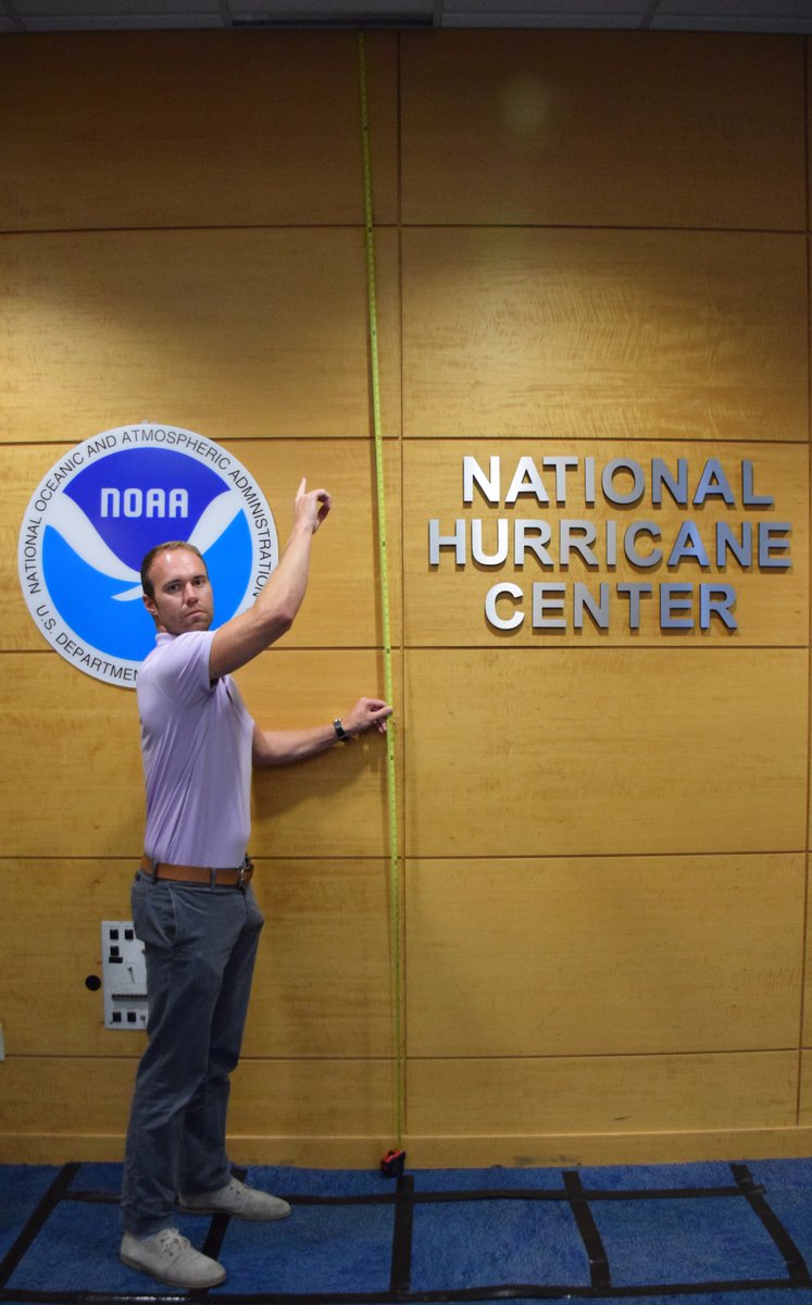
[FONT=&quot]NHC_SurgeVerified account @NHC_Surge 2h2 hours ago More


[FONT=&quot]What does the @NWS forecast of 6-12 ft of storm surge flooding from #Harvey mean? For reference, the ceiling at our office is 11 ft. @NOAA[/FONT]

[FONT=&quot]
DIEzVOgWsAEtab3.jpg
[/FONT]
[/FONT]
 
WTNT34 KNHC 251452 TCPAT4 BULLETIN Hurricane Harvey Advisory Number 21 NWS National Hurricane Center Miami FL AL092017 1000 AM CDT Fri Aug 25 2017 ...OUTER RAINBAND FROM HARVEY SWIPING THE LOWER AND MIDDLE TEXAS COASTS... ...

CATASTROPHIC FLOODING EXPECTED ACROSS PORTIONS OF SOUTHERN AND SOUTHEASTERN TEXAS...

SUMMARY OF 1000 AM CDT...1500 UTC...INFORMATION ----------------------------------------------- LOCATION...26.7N 96.0W ABOUT 115 MI...185 KM SE OF CORPUS CHRISTI TEXAS ABOUT 120 MI...195 KM SSE OF PORT OCONNOR TEXAS MAXIMUM SUSTAINED WINDS...110 MPH...175 KM/H PRESENT MOVEMENT...NW OR 315 DEGREES AT 10 MPH...17 KM/H MINIMUM CENTRAL PRESSURE...947 MB...27.97 INCHES WATCHES AND WARNINGS -------------------- CHANGES WITH THIS ADVISORY: The Hurricane Watch south of Port Mansfield Texas to the Mouth of the Rio Grande has been discontinued.

SUMMARY OF WATCHES AND WARNINGS IN EFFECT: A Storm Surge Warning is in effect for... * Port Mansfield to High Island Texas A Storm Surge Watch is in effect for... * South of Port Mansfield Texas to the Mouth of the Rio Grande A Hurricane Warning is in effect for... * Port Mansfield to Sargent Texas A Tropical Storm Warning is in effect for... * North of Sargent to High Island Texas * South of Port Mansfield Texas to the Mouth of the Rio Grande A Tropical Storm Watch is in effect for... * South of the Mouth of the Rio Grande to Boca de Catan Mexico A Storm Surge Warning means there is a danger of life-threatening inundation from rising water moving inland from the coastline in the indicated locations. For a depiction of areas at risk, please see the National Weather Service Storm Surge Watch/Warning Graphic, available at hurricanes.gov. This is a life-threatening situation. Persons located within these areas should take all necessary actions to protect life and property from rising water and the potential for other dangerous conditions. Promptly follow evacuation and other instructions from local officials. A Hurricane Warning means that hurricane conditions are expected somewhere within the warning area, in this case within the next 12 to 24 hours. Preparations to protect life and property should be rushed to completion. A Storm Surge Watch means there is a possibility of life- threatening inundation from rising water moving inland from the coastline in the indicated locations. Interests in southwestern Louisiana should continue to monitor the progress of this system. For storm information specific to your area in the United States, including possible inland watches and warnings, please monitor products issued by your local National Weather Service forecast office. For storm information specific to your area outside the United States, please monitor products issued by your national meteorological service.

DISCUSSION AND 48-HOUR OUTLOOK ------------------------------ At 1000 AM CDT (1500 UTC), the eye of Hurricane Harvey was located by an Air Force Reserve Hurricane Hunter aircraft and NOAA Doppler radar near latitude 26.7 North, longitude 96.0 West. Harvey is moving toward the northwest near 10 mph (17 km/h), but its forward speed is expected to decrease significantly during the next couple of days. On the forecast track, Harvey will make landfall on the middle Texas coast tonight or early Saturday. Harvey is then likely to meander near or just inland of the middle Texas coast through the weekend. Maximum sustained winds are near 110 mph (175 km/h) with higher gusts. Some strengthening is possible, and Harvey is forecast to become a major hurricane before it reaches the middle Texas coast. Hurricane-force winds extend outward up to 35 miles (55 km) from the center, and tropical-storm-force winds extend outward up to 140 miles (220 km). A buoy located about 40 miles east of South Padre Island recently reported sustained winds of 42 mph (68 km/h) and a gust to 54 mph (86 km/h). The minimum central pressure based on data from the Air Force plane is 947 mb (27.97 inches).

HAZARDS AFFECTING LAND ---------------------- RAINFALL: Harvey is expected to produce total rain accumulations of 15 to 25 inches and isolated maximum amounts of 35 inches over the middle and upper Texas coast through next Wednesday. During the same time period Harvey is expected to produce total rain accumulations of 5 to 15 inches in far south Texas and the Texas Hill Country over through southwest and central Louisiana. Rainfall of this magnitude will cause catastrophic and life-threatening flooding. STORM SURGE: The combination of a dangerous storm surge and the tide will cause normally dry areas near the coast to be flooded by rising waters moving inland from the shoreline. The water is expected to reach the following heights above ground if the peak surge occurs at the time of high tide... N Entrance Padre Island Natl Seashore to Sargent...6 to 12 ft Sargent to Jamaica Beach...5 to 8 ft Port Mansfield to N Entrance Padre Island Natl Seashore...5 to 7 ft Jamaica Beach to High Island...2 to 4 ft Mouth of the Rio Grande to Port Mansfield...2 to 4 ft High Island to Morgan City...1 to 3 ft The deepest water will occur along the immediate coast near and to the northeast of the landfall location, where the surge will be accompanied by large and destructive waves. Surge-related flooding depends on the relative timing of the surge and the tidal cycle, and can vary greatly over short distances. For information specific to your area, please see products issued by your local National Weather Service forecast office.

WIND: All last-minute preparations should be rushed to completion since tropical storm conditions are likely just beginning in portions of the hurricane and tropical storm warning areas. Hurricane conditions are likely to begin within the hurricane warning area later today or tonight. Tropical storm conditions are likely to persist along portions of the coast through at least Sunday.

SURF: Swells generated by Harvey are affecting the Texas, Louisiana, and northeast Mexico coasts. These swells are likely to cause life-threatening surf and rip current conditions. Please consult products from your local weather office.

TORNADOES: A few tornadoes are possible later today through Saturday near the middle and upper Texas coast. NEXT ADVISORY ------------- Next intermediate advisory at 100 PM CDT. Next complete advisory at 400 PM CDT. $$ Forecaster Berg
 
[FONT=&quot] [h=1]Governor Abbott Urges Gulf Coast Residents To Heed Warnings From Local Officials[/h] [/FONT]
August 25, 2017 | Austin, Texas | Press Release
As Hurricane Harvey approaches, Governor Greg Abbott today asked that all Texans heed the warnings of local officials, strongly consider all voluntary evacuation orders, and strictly comply with all mandatory evacuation orders. Communities along the Gulf Coast, specifically the Corpus Christi and the Houston areas, are at greatest risk of being impacted by this severe weather.

"My priority, as we prepare for Hurricane Harvey, is the safety of those on and near the Gulf Coast," said Governor Abbott. "That is why I am strongly urging all Texans in Harvey?s path to heed warnings and evacuation orders from local officials before this storm makes landfall. My office is coordinating local, state and federal resources to prepare for and respond decisively to this storm?Texans must also take action and treat this storm seriously."

The Governor also asks Texans to review important safety information and the following instructions:
  • Board up doors and windows with plywood or install storm shutters. Keep in mind that winds are stronger at higher elevations, such as high-rise apartments or condos.
  • Bring in outdoor objects that could become deadly missiles, such as patio furniture, hanging plants, trash cans, gardening tools and barbecues.
  • If your home is vulnerable to rising water, move furniture and valuables to a higher level.
  • Before evacuating, cut off your electricity and turn off the gas. Downed electrical wires and broken gas pipes can be deadly and cause serious property damage. Make a final walk-through inspection of your home before leaving.
  • Moor boats securely or move them to designated safe areas well in advance of hurricanes. Do not try to tow a trailer or boat in high winds.
  • Assemble a family emergency supplies kit and have it ready to go at a moment's notice.
  • When officials recommend or order an evacuation, leave. Do not try to ride out a hurricane in a high-risk area. Seek shelter inland with family or friends, at a hotel or designated shelter. Notify relatives and friends of your plans, and confirm hotel reservations.
  • Find out where shelters are located along your route in case clogged roads prevent you from reaching your destination.
  • Look at the evacuation maps for your area ahead of time.
  • https://gov.texas.gov/news/post/gov...st-residents-to-heed-warnings-from-local-offi
 
From personal experience I would say that people underestimate the lack of electrical power that occurs during and after one of these storms. You could be without power for a week even with all the federal and out-of-state assistance that pours into the affected areas.
 
[TABLE="class: mwmain, width: 556"]
[TR]
[TD="class: mwmaintitle"]WPC Met Watch[/TD]
[/TR]
[TR]
[TD]
[/TD]
[/TR]
[TR]
[TD="class: mwsubtitle"]Mesoscale Precipitation Discussion: #0742[/TD]
[/TR]
[TR]
[TD="class: mwissuet"](Issued at 809 AM EDT SUN AUG 27 2017 )[/TD]
[/TR]
[TR]
[TD] [/TD]
[/TR]
[TR]
[TD="class: mwversions"]MPD Selection[/TD]
[/TR]
[TR]
[TD] [TABLE="class: mwversions, border: 0, width: 510"]
[TR]
[TD="class: mwversionl"][/TD]
[TD="class: mwversionp"][/TD]
[TD="class: mwversionn"][/TD]
[TD="class: backtosummary"][/TD]
[/TR]
[/TABLE]
[/TD]
[/TR]
[TR]
[TD]
[/TD]
[/TR]
[TR]
[TD]
[/TD]
[/TR]
[TR]
[TD="class: mwdiscussion"]
mcd0742.gif

MESOSCALE PRECIPITATION DISCUSSION 0742 NWS WEATHER PREDICTION CENTER COLLEGE PARK MD 809 AM EDT SUN AUG 27 2017 AREAS AFFECTED...SOUTHEAST TX & SOUTHWEST LA CONCERNING...HEAVY RAINFALL...FLASH FLOODING LIKELY VALID 271208Z - 271808Z SUMMARY...CATASTROPHIC FLOODING IN THE HOUSTON METROPOLITAN AREA IS EXPECTED TO WORSEN AND COULD BECOME HISTORIC IN ASSOCIATION WITH HARVEY, WITH POTENTIALLY SIGNIFICANT FLOODING ALSO EXPECTED IN OTHER SATURATED AREAS OF SOUTHEAST TX. HOURLY RAIN TOTALS UP TO 3" WITH LOCAL AMOUNTS TO 7" ARE EXPECTED, BRINGING LOCAL STORM TOTAL ACCUMULATIONS TOWARD 35" LOCALLY BY 18Z. DISCUSSION...A COMBINATION OF DRIER/STABLE LOW LEVEL AIR HAS INFILTRATED THE CENTER AND FORCED THE CONVECTIVE PATTERN AROUND THE SYSTEM TO RESEMBLE A CONVECTIVE T-BONE STRUCTURE. A SIGNIFICANT DEW POINT GRADIENT IS SHOWING UP SOUTH OF ITS CENTER NEAR THE COAST OF MAINLAND TX -- WEST OF PADRE ISLAND, EXTENDING RIGHT UP THE COAST BEFORE CURLING NORTHWARD WEST OF ANGLETON TX. MID-LEVEL DRY AIR IS IMPINGING ON ITS WESTERN SIDE -- THERE IS THE APPEARANCE OF SOME WESTERLY VERTICAL WIND SHEAR OVER HARVEY. BANDS OF DEEP CONVECTION CONTINUE TO ROTATE INTO GALVESTON, HOUSTON, AND AREAS NORTHEAST OF PALACIOS TX OVER 100 MILES FROM THE CENTER OF HARVEY, WHOSE CENTER IS SLOWLY EDGING AWAY FROM THE AREA. HOURLY RAIN TOTALS PER RECENT RADAR ESTIMATES HAVE FALLEN TO ABOUT 3", WHICH CORRESPONDS TO HARRIS COUNTY EMERGENCY MANAGEMENT RAIN GAGE TOTALS. RAIN TOTALS OVER THE PAST 48 HOURS HAVE REACHED 27" IN SOUTHEAST HARRIS COUNTY, WITH AMOUNTS CLOSER TO 12" ACROSS NORTHERN AND WESTERN HARRIS COUNTY. VOLUME-WISE, THIS HAS LIKELY REACHED THE RAINFALL THAT FELL DURING ALLISON IN JUNE 2001, AND IT CONTINUES TO RAIN. BOTH THE ML CAPES AND MU CAPES HAVE BEEN SLOWLY DECLINING, WHICH LIKELY EXPLAINS THE REDUCING HOURLY RAIN RATES, WITH VALUES NEAR 1000 J/KG ALONG THE UPPER TX COAST. INFLOW AT 850 HPA IS CYCLONIC, OUT OF THE SOUTHEAST AT 35-45 KTS PER VAD WIND PROFILES. PRECIPITABLE WATER VALUES ARE ~ 2.75". SPIRAL BANDS TEND TO MOVE AWAY FROM THE CENTER OF CONVECTIVE LOWS, SO IT IS POSSIBLE THAT THE BANDING IN THE GALVESTON/HOUSTON AREA COULD CONTINUE FOR SEVERAL MORE HOURS -- FOR AS LONG AS THE STORM IS DRIFTING SOUTHWARD. ANY EASTWARD DRIFT WOULD POTENTIALLY MOVE THE HEAVIEST RAIN AXIS EASTWARD. MEANWHILE, TO THE NORTHEAST, ISSUES ARE EXPECTED ACROSS THE GOLDEN TRIANGLE OF SOUTHEAST TX AND IMPERIAL CALCASIEU AS RECENT RAINS HAVE LOWERED FLASH FLOOD GUIDANCE VALUES AND CONVECTION FROM THE SLOWLY INCOMING BAND OCCASIONALLY MERGES IN WITH THUNDERSTORMS ALONG AN EFFECTIVE STATIONARY FRONT TO ITS EAST-NORTHEAST. RAINFALL HAS BEEN WELL ABOVE AVERAGE IN SOUTHWEST LA AND DAM ISSUES REMAIN IN PORT ARTHUR TX. THE MESOSCALE GUIDANCE SHOWS A SLOW RETREAT IN RAINFALL RATES/AMOUNTS WHEN COMPARED TO OVERNIGHT AND EARLIER THIS MORNING, BUT THE DAMAGE HAS BEEN DONE. THE MESOSCALE GUIDANCE INDICATES LOCAL AMOUNTS TO 7", WITH HOURLY RAIN TOTALS UP TO 3" EXPECTED. THIS WOULD ELEVATE THE CATASTROPHIC FLOOD EVENT INTO RECORD TERRITORY FOR THE HOUSTON METROPOLITAN AREA. ROTH ATTN...WFO...CRP...EWX...FWD...HGX...LCH...SHV... ATTN...RFC...LMRFC...WGRFC... LAT...LON 31369488 30229234 29519258 29709352 29179477 28299649 28299715 29459862 30919765
Last Updated: 809 AM EDT SUN AUG 27 2017 [/TD]
[/TR]
[/TABLE]


http://www.wpc.ncep.noaa.gov/metwatch/metwatch_mpd_multi.php?md=0742&yr=2017
 
ZCZC MIATCDAT4 ALL
TTAA00 KNHC DDHHMM

Tropical Storm Harvey Discussion Number 29
NWS National Hurricane Center Miami FL AL092017
1000 AM CDT Sun Aug 27 2017

Harvey continues to meander over southeastern Texas, where it
is producing catastrophic and life-threatening flooding rainfall.
NWS radars show that bands of deep convection continue to develop
over the northwestern Gulf of Mexico and train over portions of
southeastern Texas, including the Houston/Galveston metropolitan
area. Rainfall amounts greater than 20-25 inches have already been
reported and flash flood emergencies and warnings have been issued
by local National Weather Service offices for a large portion of
southeastern Texas. Additional rainfall amounts of 15 to 25 inches
are expected over the next several days, and the NOAA Weather
Prediction Center is now forecasting isolated storm total amounts of
50 inches.
These historic rainfall amounts will exacerbate the
already dire and life-threatening situation.

Surface observations of winds 30-35 kt within a band of convection
over the western Gulf of Mexico and along the coast of Texas support
an initial intensity of 35 kt. The latest track guidance show
Harvey moving slowly southeastward for the next 24 to 36 hours and
the center is likely to move very close to the coast, or even
offshore, between 24-48 hours.
After that time, Harvey is expected
to begin a northward motion which should take it inland over eastern
Texas later in the period. Since a large portion of the circulation
is expected to remain over water during the next several days,
Harvey is maintained as a tropical storm through 72 hours.
However,
the strongest winds are likely to occur over the Gulf waters.

Key Messages:

1. Ongoing catastrophic and life-threatening flooding will continue
across southeastern Texas. Additional rainfall accumulations of 15
to 25 inches are expected, with isolated storm totals as high as 50
inches, through Friday. Please heed the advice of local officials.
Do not attempt to travel if you are in a safe place, and do not
drive into flooded roadways. Refer to products from your local
National Weather Service office and the NOAA Weather Prediction
Center for more information on the flooding hazard. A summary of
rainfall totals compiled by the Weather Prediction Center can be
found at: www.wpc.ncep.noaa.gov/discussions/nfdscc1.html


FORECAST POSITIONS AND MAX WINDS

INIT 27/1500Z 29.0N 97.4W 35 KT 40 MPH
12H 28/0000Z 28.6N 97.3W 35 KT 40 MPH...INLAND
24H 28/1200Z 28.4N 96.8W 35 KT 40 MPH...INLAND
36H 29/0000Z 28.2N 96.3W 35 KT 40 MPH...OVER WATER
48H 29/1200Z 28.2N 96.0W 35 KT 40 MPH...OVER WATER
72H 30/1200Z 29.3N 95.7W 35 KT 40 MPH...INLAND
96H 31/1200Z 30.9N 95.5W 30 KT 35 MPH...INLAND
120H 01/1200Z 32.2N 95.1W 25 KT 30 MPH...INLAND


$$
Forecaster Brown

NNNN

http://www.nhc.noaa.gov/text/refresh/MIATCDAT4+shtml/271458.shtml?
 
DIP4jxIW0AEcHuG.jpg:large


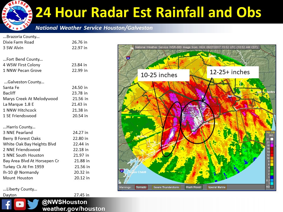
Catastrophic flooding is ongoing with flash flood emergencies remaining in effect. The treat for continued additional catastrophic, unprecedented, and life threatening flooding is expected today and into next week with heavy rain from bands coming off the Gulf. Flash Flood Watches and Warnings are currently in effect for all of southeast Texas.

http://www.weather.gov/hgx/
 
Since so many major media are covering this historic event we have not been posting a lot of news stories. We are posting links to obtain help. It has been hard to even comment because the situation has been changing so quickly. At one point it was advisable to evacuate and then later in the same afternoon it was better to shelter in place.

At this point it seems that this situation will probably equal the devastation of Katrina. I have lived through hurricanes but not massive flooding. In general, homes and buildings that have been flooded are not habitable. In a few days the rotting houses will become a hazard to everyone's health. So even if you are comfortable on your 2nd floor now, you will need to find a sanitary place to live until your home is repaired. Please view the links above that Pathfinder and I have posted.

We wish everyone affected by Harvey and the flooding all the very best and please be safe. It will be a long recovery.
 
CDC Media Advisory: Stay Safe after Hurricanes, Flooding - Links - August 29, 2017

From: "Media@cdc.gov (CDC)" <sohco@CDC.GOV>
To: MMWR-MEDIA@LISTSERV.CDC.GOV
Subject: CDC Media Advisory: Stay Safe after Hurricanes, Flooding
Date: Aug 29, 2017 9:52 AM

[TABLE="border: 0, cellpadding: 0, cellspacing: 0"]
[TR]
[TD]Media Advisory


For Immediate Release
Tuesday, August 29, 2017

Contact: CDC Media Relations
404-639-3286

Stay Safe after Hurricanes, Flooding

Hurricanes can cause dangerous and destructive high winds, flooding, heavy rain, and storm surges. Keep your family safe aftera hurricane has made landfall. There may be a risk of carbon monoxide poisoning, downed power lines, and mold, among others. For tips on how to be safe after a hurricane: https://www.cdc.gov/disasters/hurricanes/after.html . Below are a few key recommendations:

? Don&#146;t go to the attic of your home. If the highest floor of your home becomes dangerous, get on the roof. Call 911 for help and stay on the line until the call is answered.
? Avoid driving through flooded areas, especially when the water is fast moving.
o As little as six inches of water can cause you to lose control of your vehicle.
? Avoid Carbon Monoxide (CO) poisoning after a disaster. Only use a portable generator outdoors in a dry area at least 20 feet away from doors, windows and vents that can allow CO to come indoors.
? Avoid injuries when you return to your home after the storm.
? Protect yourself from mosquito bites and reduce the number of mosquitoes in your area.
? Be prepared to cope with feelings of fear, grief and depression after a traumatic event.

  • The Disaster Distress Helpline ( www.disasterdistress.samhsa.gov ) provides 24/7, year-round crisis counseling and support. Call 1-800-985-5990 (TTY for deaf/hearing impaired: 1-800-846-8517) or text TalkWithUs to 66746.
Be safe if it floods

? Follow local flood watches, warnings and instructions.
o Get to higher ground. Get out of areas subject to flooding. This includes dips, low spots, canyons, or washes.
o Return to your flooded home only after local authorities have told you it is safe to do so.

  • If evacuation appears necessary, turn off all utilities at the main power switch and close the main gas valve.
  • Have your immunization records handy or be aware of your last tetanus shot, in case you receive a puncture wound or a wound becomes infected during or after the flood.
? Listen for water advisory from local authorities to find out if your water is safe for drinking and bathing.
? Fill bathtubs, sinks and plastic soda bottles with clean water. Sanitize the sinks and tubs first by using bleach. Rinse and fill with clean water.
? Throw away any food and bottled water that may have come in contact with flood or storm water. Learn how to save undamaged food packages exposed to flood water.
? Use bleach to clean mold off of hard things like floors, stoves, sinks, countertops, plates, and tools.
o Dilute bleach to the proper concentration
? Throw out items that cannot be washed and cleaned with bleach, such as mattresses, pillows, carpeting, carpet padding, and stuffed toys.
? Remove and throw out drywall and insulation contaminated with sewage or flood waters.

  • Thoroughly clean all hard surfaces, such as concrete, wood, and metal furniture, countertops, and appliances, with hot water and laundry or dish detergent.
Keep food safe
  • To keep your food at safe temperatures the longest, avoid opening your refrigerator and freezer. Your refrigerator will keep food cold for about four hours if the doors stay closed, and a full freezer will maintain its temperature for approximately 48 hours. A half-full freezer only maintains its temperature for about 24 hours.
  • Place appliance thermometers in your refrigerator and freezer so you will know if food is at a safe temperature. Set your freezer at or below 0?F, and your refrigerator at or below 40?F.
  • If food in your freezer has ice crystals or is below 40?F, the food may be safely refrozen.
  • When it comes to the safety of your food, when in doubt, throw it out.
  • Learn more at www.foodsafety.gov .
Keep pets safe
  • Contact your local emergency management office and ask if they have shelter for owners and pets in an evacuation.
  • Disasters are stressful for humans and pets alike. Practice safe handling; your pet may behave differently during a stressful situation.
  • Exposure to weather, stagnant water, wildlife or unfamiliar animals, and overcrowding can put your pet at risk for getting sick. Some of these illnesses can be spread to people .
  • If you and your pet are separated, get your family is in a safe location before you begin your search.
  • Learn more: https://www.cdc.gov/features/petsand...ers/index.html
Public Service Announcements

CDC has hurricane public service announcements (PSAs), including some in Spanish and American Sign Language:
? Cleanup
? Food and Water Safety
? Injury and Disease Safety
? Medication Safety
? Stay Safe at Home After a Tropical Storm or Hurricane
? Stay Safe Outside After a Tropical Storm or Hurricane

Media Toolkits

###
U.S. Department of Health and Human Services

CDC works 24/7 protecting America&#146;s health, safety, and security. Whether diseases start at home or abroad, are curable or preventable, chronic or acute, or from human activity or deliberate attack, CDC responds to America&#146;s most pressing health threats. CDC is headquartered in Atlanta and has experts located throughout the United States and the world.
[/TD]
[/TR]
[/TABLE]
 
Harvey floodwaters overflow Houston reservoir, separate levee breach reported

[FONT=&quot]By Travis FedschunPublished August 29, 2017 Fox News[/FONT]

[FONT=&quot][FONT=&quot]...
Floodwaters in the the Addicks Reservoir, located about 19 miles west of downtown, went over the top of the 108-foot spillway for the first time in history, threatening immediate surrounding subdivisions.
[/FONT]

...
"This is not going to happen fast, this is a slow rise," Lindner told reporters, adding the flow of water going over the reservoir into neighborhoods will increase as the levels in the reservoir behind continue to rise.
[/FONT]


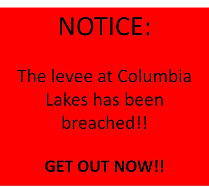
[FONT=&quot]Hours after the Addicks Reservoir was overtopped, officials in Brazoria County, located south of Houston, warned that a levee at Columbia Lakes had been breached by floodwaters and urged any residents who had not already evacuated the area to leave immediately, writing "GET OUT NOW!!"[/FONT]
[FONT=&quot] [/FONT]
...
[FONT=&quot]http://www.foxnews.com/us/2017/08/29...territory.html[/FONT]
 
How to Help Disaster Surivivors in Texas

Release Date:
August 29, 2017


For Immediate Release
FEMA News Desk
Phone: 202-646-3272

WASHINGTON &#150; The compassion and generosity of the American people is never more evident than during and after a disaster. It is individuals, non-profits, faith- and community-based organizations, private sector partners, and governmental agencies working together that will most effectively and efficiently help survivors cope with the impacts of Tropical Storm Harvey.
Please follow a few important guidelines below to ensure your support can be the most helpful for Tropical Storm Harvey disaster survivors.

To Donate to Relief Efforts

The most effective way to support disaster survivors in their recovery is to donate money and time to trusted, reputable, voluntary or charitable organizations.

Cash donations offer voluntary agencies and faith-based organizations the most flexibility to address urgently developing needs. With cash in hand, these organizations can obtain needed resources nearer to the disaster location. This inflow of cash also pumps money back into the local economy and helps local businesses recover faster.

Please do not donate unsolicited goods such as used clothing, miscellaneous household items, medicine, or perishable foodstuffs at this time. When used personal items are donated, the helping agencies must redirect their staff away from providing direct services to survivors in order to sort, package, transport, warehouse, and distribute items that may not meet the needs of disaster survivors.

Donate through a trusted organization. At the national level, many voluntary-, faith- and community-based organizations are active in disasters, and are trusted ways to donate to disaster survivors. Individuals, corporations, and volunteers, can learn more about how to help on the National Voluntary Organizations Active in Disaster (NVOAD) website.

In addition to the national members, The Texas Voluntary Organizations Active in Disaster (Texas VOAD) has a list of vetted disaster relief organizations providing services to survivors. Texas VOAD represents more than three dozen faith-based, community, nonprofit and non-governmental organizations.

To Personally Volunteer in the Disaster Areas

The State of Texas is asking volunteers to not self-deploy, as unexpectedly showing up to any of the communities that have been impacted by Hurricane Harvey will create an additional burden for first responders.

The National VOAD has also noted the situation may not be conducive to volunteers entering the impacted zone and individuals may find themselves turned away by law enforcement.

To ensure volunteer safety, as well as the safety of disaster survivors, volunteers should only go into affected areas with a specific volunteer assignment, proper safety gear, and valid identification.

At this time, potential volunteers are asked to register with a voluntary or charitable organization of their choice, many of which are already in Texas and supporting survivors on the ground.

The National and Texas VOAD websites are offering links to those who wish to register to volunteer with community- and faith-based organizations working in the field.

Most importantly, please be patient. Although the need is great, and desire to help strong, it is important to avoid donating material goods or self-deploying to help until communities are safe and public officials and disaster relief organizations have had an opportunity to assess the damage and identify what the specific unmet needs are.

Volunteer generosity helps impacted communities heal from the tragic consequences of disasters, but recovery lasts much longer than today. There will be volunteer needs for many months, and years, after the disaster, so sign up now.

Tropical Storm Harvey is still dangerous, with the potential to impact additional areas of Texas and Louisiana. As the situation changes, needs may also change in these areas. Continue monitoring traditional and social media channels to learn more.
 
Back
Top Bottom