

Install the app
How to install the app on iOS
Follow along with the video below to see how to install our site as a web app on your home screen.
Note: This feature may not be available in some browsers.
-
FluTrackers.com Inc. does not provide medical advice. Information on this web site is collected from various internet resources, and the FluTrackers board of directors makes no warranty to the safety, efficacy, correctness or completeness of the information posted on this site by any author or poster. The information collated here is for instructional and/or discussion purposes only and is NOT intended to diagnose or treat any disease, illness, or other medical condition. Every individual reader or poster should seek advice from their personal physician/healthcare practitioner before considering or using any interventions that are discussed on this website. By continuing to access this website you agree to consult your personal physican before using any interventions posted on this website, and you agree to hold harmless FluTrackers.com Inc., the board of directors, the members, and all authors and posters for any effects from use of any medication, supplement, vitamin or other substance, device, intervention, etc. mentioned in posts on this website, or other internet venues referenced in posts on this website. -
We are not asking for any donations. Do not donate to any entity who says they are raising funds for us.
- Home
- Forums
- Forum
- Earth, Weather, Astronomy & Environment
- Volcanos, Earthquakes, Glaciers, Fires, Hurricanes
You are using an out of date browser. It may not display this or other websites correctly.
You should upgrade or use an alternative browser.
You should upgrade or use an alternative browser.
Historic Hurricane Melissa will be a Direct Hit into Jamaica - Videos, NHC info - October 26, 2025+, tambien parte de Cuba
- Thread starter sharon sanders
- Start date
sharon sanders
Editor-in-Chief & President

Pathfinder
Editor, Senior Moderator
Hurricane Melissa Public Advisory
[TABLE="border: 0, cellpadding: 0, cellspacing: 0"]
[TR]
[TD]Home Public Adv Fcst Adv Discussion Wind Probs Graphics Archive
Español: Aviso Publico Discusión
[/TD]
[/TR]
[/TABLE]
000
WTNT33 KNHC 261456
TCPAT3
BULLETIN
Hurricane Melissa Advisory Number 21
NWS National Hurricane Center Miami FL AL132025
1100 AM EDT Sun Oct 26 2025
...MAJOR HURRICANE MELISSA CONTINUES SLOWLY WESTWARD WITH LITTLE
CHANGE IN STRENGTH...
...LIFE-THREATENING AND CATASTROPHIC FLASH FLOODING AND LANDSLIDES
EXPECTED IN PORTIONS OF JAMAICA AND SOUTHERN HISPANIOLA THROUGH
MIDWEEK...
SUMMARY OF 1100 AM EDT...1500 UTC...INFORMATION
-----------------------------------------------
LOCATION...16.4N 76.6W
ABOUT 110 MI...180 KM S OF KINGSTON JAMAICA
ABOUT 280 MI...445 KM SSW OF GUANTANAMO CUBA
MAXIMUM SUSTAINED WINDS...140 MPH...220 KM/H
PRESENT MOVEMENT...W OR 270 DEGREES AT 3 MPH...6 KM/H
MINIMUM CENTRAL PRESSURE...953 MB...28.15 INCHES
WATCHES AND WARNINGS
--------------------
CHANGES WITH THIS ADVISORY:
None.
SUMMARY OF WATCHES AND WARNINGS IN EFFECT:
A Hurricane Warning is in effect for...
* Jamaica
A Hurricane Watch is in effect for...
* Southwestern peninsula of Haiti from the border with the
Dominican Republic to Port-Au-Prince
* Cuban provinces of Granma, Santiago de Cuba, Guantanamo, and
Holguin.
A Tropical Storm Warning in effect for...
* Southwestern peninsula of Haiti from the border with the
Dominican Republic to Port-Au-Prince
A Hurricane Warning means that hurricane conditions are expected
somewhere within the warning area. A warning is typically issued
36 hours before the anticipated first occurrence of
tropical-storm-force winds, conditions that make outside
preparations difficult or dangerous. Preparations to protect life
and property should be complete.
A Hurricane Watch means that hurricane conditions are possible
within the watch area.
A Tropical Storm Warning means that tropical storm conditions are
expected somewhere within the warning area within 36 hours.
Interests elsewhere in Haiti, the Dominican Republic, Cuba, the
southeastern and central Bahamas, and the Turks and Caicos Islands,
and Bermuda should monitor the progress of Melissa. Additional
watches and warnings could be required later today.
For storm information specific to your area, please monitor
products issued by your national meteorological service.
DISCUSSION AND OUTLOOK
----------------------
At 1100 AM EDT (1500 UTC), the eye of Hurricane Melissa was located
by NOAA Hurricane Hunter aircraft near latitude 16.4 North,
longitude 76.6 West. Melissa is moving toward the west near 3 mph
(6 km/h). A slow westward motion is expected today, followed by a
turn to the north and northeast on Monday and Tuesday. On the
forecast track, the core of Melissa is expected to move near or
over Jamaica on Tuesday, across southeastern Cuba Tuesday
night, and across the southeastern Bahamas on Wednesday.
Maximum sustained winds are near 140 mph (220 km/h) with higher
gusts. Melissa is a category 4 hurricane on the Saffir-Simpson
Hurricane Wind Scale. Additional intensification is forecast over
the next day or so, followed by fluctuations in intensity. Melissa
is expected to be a powerful major hurricane when making landfall in
Jamaica Monday night or Tuesday morning and southeastern Cuba late
Tuesday.
Hurricane-force winds extend outward up to 25 miles (35 km) from the
center and tropical-storm-force winds extend outward up to 175 miles
(280 km).
The minimum central pressure estimated by aircraft dropsonde data
is 953 mb (28.15 inches).
HAZARDS AFFECTING LAND
----------------------
Key messages for Melissa can be found in the Tropical Cyclone
Discussion under AWIPS header MIATCDAT3 and WMO header WTNT43 KNHC.
WIND: Tropical storm conditions are likely occuring in Jamaica, with
hurricane conditions expected to begin by Monday. Tropical storm
conditions are expected in the warning area in Haiti today. The
potential for hurricane conditions in the watch area in Haiti have
diminished for today, but there is still a possibility of hurricane
conditions occurring there on Tuesday. Hurricane conditions are
possible in the watch area in eastern Cuba on Tuesday into
Wednesday.
RAINFALL: Melissa is expected to bring storm total rainfall of 15 to
30 inches to portions of southern Hispaniola and Jamaica through
Wednesday, with local maxima of 40 inches possible. Catastrophic
flash flooding and numerous landslides are likely.
For eastern Cuba, total rainfall of 10 to 15 inches, with local
amounts to 20 inches, is expected by Tuesday into Wednesday
resulting in life-threatening flash flooding and numerous
landslides.
Over the Southeast Bahamas, total rainfall of 4 to 8 inches is
expected Tuesday into Wednesday resulting in areas of flash
flooding. Over the Turks and Caicos, total rainfall of 1 to 4
inches is expected Tuesday into Wednesday.
For a complete depiction of forecast rainfall associated with
Melissa, please see the National Weather Service Storm Total
Rainfall Graphic, available at
hurricanes.gov/graphics_at3.shtml?rainqpf
STORM SURGE: Life-threatening storm surge is likely along the south
coast of Jamaica late Monday through Tuesday morning. Peak
storm surge heights could reach 9 to 13 feet above ground level,
near and to the east of where the center of Melissa makes landfall.
This storm surge will be accompanied by large and destructive waves.
There is a potential for significant storm surge along the
southeast coast of Cuba late Tuesday or Wednesday.
SURF: Swells generated by Melissa are expected to affect portions of
Hispaniola, Jamaica, eastern Cuba, and the Cayman Islands during the
next several days. These swells are likely to cause
life-threatening surf and rip current conditions. Please consult
products from your local weather office.
NEXT ADVISORY
-------------
Next intermediate advisory at 200 PM EDT.
Next complete advisory at 500 PM EDT.
$$
Forecaster Papin
https://www.nhc.noaa.gov/text/refresh/MIATCPAT3+shtml/261456.shtml?
-------------------------------------------------------------------------------
Hurricane Melissa Forecast Discussion
[TABLE="border: 0, cellpadding: 0, cellspacing: 0"]
[TR]
[TD]Home Public Adv Fcst Adv Discussion Wind Probs Graphics Archive
Español: Aviso Publico Discusión
[/TD]
[/TR]
[/TABLE]
000
WTNT43 KNHC 261459
TCDAT3
Hurricane Melissa Discussion Number 21
NWS National Hurricane Center Miami FL AL132025
1100 AM EDT Sun Oct 26 2025
After rapidly intensifying over the past day or so, NOAA-P3 aircraft
data indicates that Melissa's intensity has leveled off this
morning. Melissa remains a very formidable hurricane on satellite
imagery, with a clearing eye quite evident on morning visible
imagery, and the eye temperature has warmed to +15-20C. Meanwhile
the eyewall convection continues to remain robust with cloud tops as
low as -75 to -80C encircling the core. With that said, the eye
presentation from the Kingston, Jamaica radar is not as pristine,
with the eyewall occasionally open on the east side, and some
evidence of concentric bands forming off and on. Zooming out a bit,
there still remains some evidence of light to moderate westerly
shear undercutting the expanding storm outflow, and Melissa’s
primarily rainbands are distributed mostly on the eastern side of
the circulation. NOAA-P3 aircraft data this morning had a peak 700-
mb flight level wind of 120 kt, and Tail Doppler Radar (TDR) wind
retrievals were up to 129 kt at 0.5 km, and 129 kt in the 500 m
average of a dropsonde launched in the north eyewall. While this
data would support a somewhat lower intensity, the subjective and
objective satellite based intensity estimates are mostly higher,
ranging from 115 to 140 kt. The initial intensity will be held at
120 kt, on the lower end of those estimates, and this value could be
a little generous based on the aircraft data.
The major hurricane is moving westward this morning, from aircraft
fixes estimated at 270/3 kt. This motion is expected to continue for
the next 24-36 h as a narrow mid-level ridge to the north of Melissa
imparts the majority of the steering. Thereafter, a short-wave
trough moving into the southeastern United States is expected to
erode this ridge, allowing Melissa to turn sharply to the northeast,
with gradual acceleration. On the forecast track, Melissa's core
is expected to be near the Jamaica coastline by Tuesday morning,
moving across the island and then approaching and moving over
eastern Cuba by Tuesday night. While the track guidance has become
tightly clustered over the first 24-48 hours, the along-track spread
starts to increase significantly after that time period, with Google
DeepMind ensemble solutions on Wednesday morning ranging from
between Jamaica and eastern Cuba in the Caribbean Sea, over eastern
Cuba, or in the Southwestern Atlantic near the Southeastern Bahamas
and Turks and Cacaos Islands. The latest NHC track forecast was
nudged just a little westward of the prior track, once again
blending the reliable track aids HFIP Corrected Consensus Approach
(HCCA), and Google DeepMind ensemble mean (GDMI).
It is unclear if the current pause in Melissa's intensification is
temporary. While there have not been obvious indications of a
secondary eyewall formation yet, there are some concentric
reflectivity bands appearing on both Jamaica and NOAA-P3 TDR data
occasionally, though the inner eyewall remains strong. Some of the
guidance this morning has actually increased from yesterday at this
time, and notably both the HAFS-A/B explicitly forecast a Category 5
hurricane shortly before they show landfall in Jamaica. The latest
NHC intensity forecast will continue to show a peak intensity of 140
kt. However, inner-core fluctuations like eyewall replacement cycles
could occur at any time. Regardless, Melissa is forecast to reach
Jamaica as an upper-end category 4 hurricane, which will only
exacerbate any damages caused by heavy rainfall and flooding over
the next 2 days. Melissa will likely weaken some as it traverses
over the higher terrain of Jamaica, but it is still forecast to be a
major hurricane when it subsequently moves over eastern Cuba in
60-72 hours. Thereafter, increasing southwesterly shear should
cause gradual weakening, but Melissa could still be near hurricane
intensity when it makes it closest approach to Bermuda in about 5
days. The latest NHC intensity forecast is on the high end of the
intensity guidance, but not far off the GDMI, and HAFS-A/B intensity
aids.
Key Messages:
1. Jamaica: Seek shelter now. Damaging winds and heavy rainfall
today and Monday will cause catastrophic and life-threatening flash
flooding and numerous landslides before potentially devastating
winds arrive Monday night and Tuesday morning. Extensive
infrastructural damage, long-duration power and communication
outages, and isolation of communities are expected. Life-threatening
storm surge is likely along portions of the southern coast Monday
night and Tuesday morning.
2. Haiti: Catastrophic and life-threatening flash flooding and
landslides are expected across southwestern Haiti through midweek,
likely causing extensive infrastructural damage and isolation of
communities. Although winds are temporarily decreasing on the
Tiburon peninsula, they could increase again across much of western
Haiti on Tuesday.
3. Dominican Republic: Heavy rainfall through midweek could produce
catastrophic flash flooding and numerous landslides in southern
portions of the country.
4. Eastern Cuba, Southeast Bahamas, and the Turks and Caicos:
Monitor Melissa closely. There is an increasing risk of a
significant storm surge, damaging winds, and heavy rainfall Tuesday
and Wednesday. In eastern Cuba, the risk of life-threatening flash
flooding and landslides is increasing. A Hurricane Watch is in
effect for portions of eastern Cuba.
FORECAST POSITIONS AND MAX WINDS
INIT 26/1500Z 16.4N 76.6W 120 KT 140 MPH
12H 27/0000Z 16.4N 77.1W 130 KT 150 MPH
24H 27/1200Z 16.6N 77.8W 140 KT 160 MPH
36H 28/0000Z 16.9N 78.0W 140 KT 160 MPH
48H 28/1200Z 17.8N 77.7W 135 KT 155 MPH
60H 29/0000Z 19.2N 76.6W 110 KT 125 MPH
72H 29/1200Z 20.9N 75.1W 95 KT 110 MPH
96H 30/1200Z 25.5N 71.0W 85 KT 100 MPH
120H 31/1200Z 32.0N 65.5W 75 KT 85 MPH
$$
Forecaster Papin
https://www.nhc.noaa.gov/text/refresh/MIATCDAT3+shtml/261459.shtml
--------------------------------------------------------------------
(screenshots)
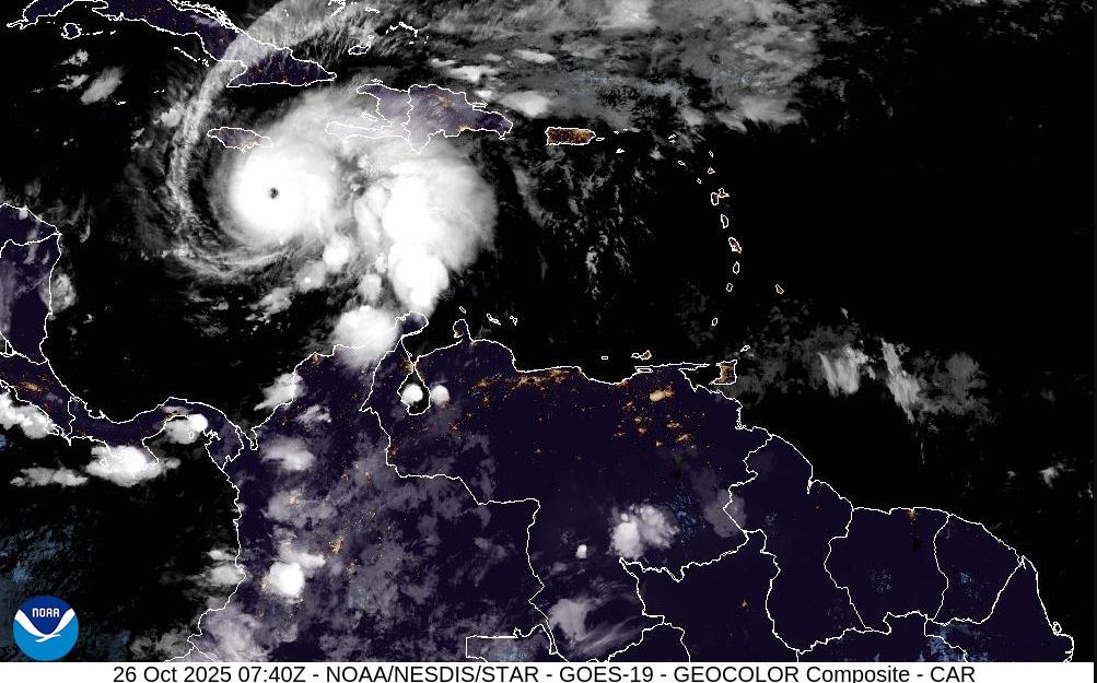
https://cdn.star.nesdis.noaa.gov/GOES19/ABI/SECTOR/car/GEOCOLOR/1000x1000.jpg
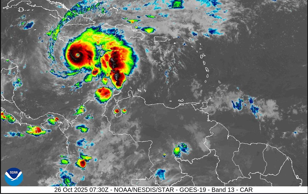
https://cdn.star.nesdis.noaa.gov/GOES19/ABI/SECTOR/car/13/1000x1000.jpg
-----------------------------------------------------------------------------------------------------------
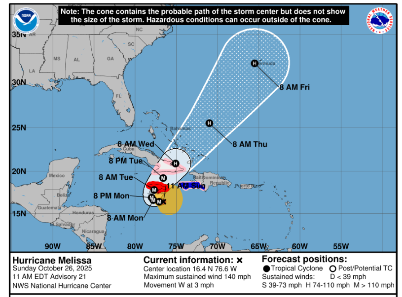
https://www.nhc.noaa.gov/refresh/graphics_at3+shtml/261456.shtml?cone#contents
---------------------------------------------------------------------------------------------------------
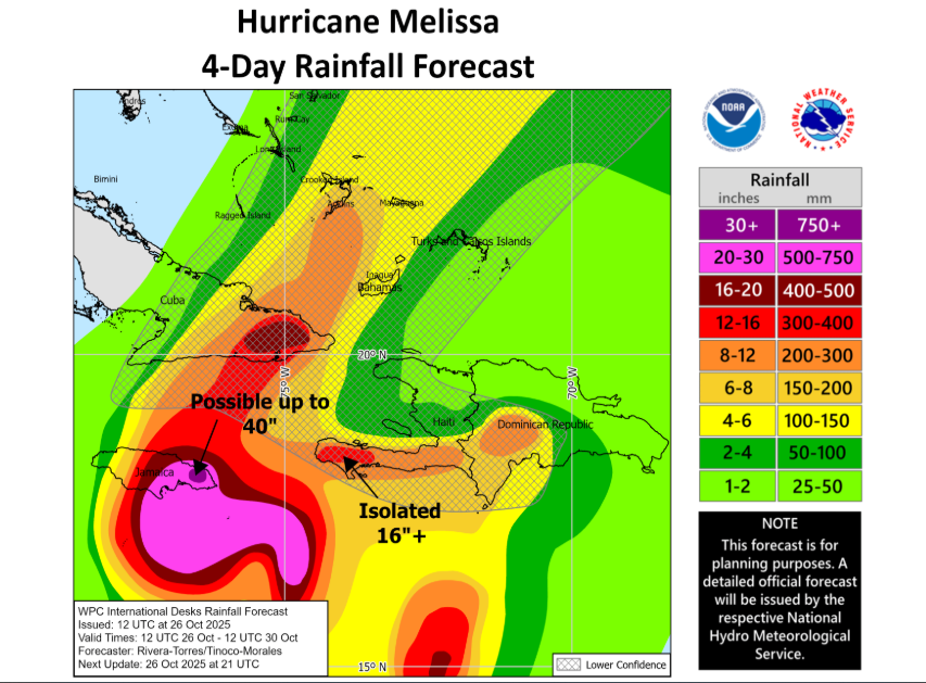
https://www.nhc.noaa.gov/refresh/graphics_at3+shtml/261456.shtml?rainqpf#contents
[TABLE="border: 0, cellpadding: 0, cellspacing: 0"]
[TR]
[TD]Home Public Adv Fcst Adv Discussion Wind Probs Graphics Archive
Español: Aviso Publico Discusión
[/TD]
[/TR]
[/TABLE]
000
WTNT33 KNHC 261456
TCPAT3
BULLETIN
Hurricane Melissa Advisory Number 21
NWS National Hurricane Center Miami FL AL132025
1100 AM EDT Sun Oct 26 2025
...MAJOR HURRICANE MELISSA CONTINUES SLOWLY WESTWARD WITH LITTLE
CHANGE IN STRENGTH...
...LIFE-THREATENING AND CATASTROPHIC FLASH FLOODING AND LANDSLIDES
EXPECTED IN PORTIONS OF JAMAICA AND SOUTHERN HISPANIOLA THROUGH
MIDWEEK...
SUMMARY OF 1100 AM EDT...1500 UTC...INFORMATION
-----------------------------------------------
LOCATION...16.4N 76.6W
ABOUT 110 MI...180 KM S OF KINGSTON JAMAICA
ABOUT 280 MI...445 KM SSW OF GUANTANAMO CUBA
MAXIMUM SUSTAINED WINDS...140 MPH...220 KM/H
PRESENT MOVEMENT...W OR 270 DEGREES AT 3 MPH...6 KM/H
MINIMUM CENTRAL PRESSURE...953 MB...28.15 INCHES
WATCHES AND WARNINGS
--------------------
CHANGES WITH THIS ADVISORY:
None.
SUMMARY OF WATCHES AND WARNINGS IN EFFECT:
A Hurricane Warning is in effect for...
* Jamaica
A Hurricane Watch is in effect for...
* Southwestern peninsula of Haiti from the border with the
Dominican Republic to Port-Au-Prince
* Cuban provinces of Granma, Santiago de Cuba, Guantanamo, and
Holguin.
A Tropical Storm Warning in effect for...
* Southwestern peninsula of Haiti from the border with the
Dominican Republic to Port-Au-Prince
A Hurricane Warning means that hurricane conditions are expected
somewhere within the warning area. A warning is typically issued
36 hours before the anticipated first occurrence of
tropical-storm-force winds, conditions that make outside
preparations difficult or dangerous. Preparations to protect life
and property should be complete.
A Hurricane Watch means that hurricane conditions are possible
within the watch area.
A Tropical Storm Warning means that tropical storm conditions are
expected somewhere within the warning area within 36 hours.
Interests elsewhere in Haiti, the Dominican Republic, Cuba, the
southeastern and central Bahamas, and the Turks and Caicos Islands,
and Bermuda should monitor the progress of Melissa. Additional
watches and warnings could be required later today.
For storm information specific to your area, please monitor
products issued by your national meteorological service.
DISCUSSION AND OUTLOOK
----------------------
At 1100 AM EDT (1500 UTC), the eye of Hurricane Melissa was located
by NOAA Hurricane Hunter aircraft near latitude 16.4 North,
longitude 76.6 West. Melissa is moving toward the west near 3 mph
(6 km/h). A slow westward motion is expected today, followed by a
turn to the north and northeast on Monday and Tuesday. On the
forecast track, the core of Melissa is expected to move near or
over Jamaica on Tuesday, across southeastern Cuba Tuesday
night, and across the southeastern Bahamas on Wednesday.
Maximum sustained winds are near 140 mph (220 km/h) with higher
gusts. Melissa is a category 4 hurricane on the Saffir-Simpson
Hurricane Wind Scale. Additional intensification is forecast over
the next day or so, followed by fluctuations in intensity. Melissa
is expected to be a powerful major hurricane when making landfall in
Jamaica Monday night or Tuesday morning and southeastern Cuba late
Tuesday.
Hurricane-force winds extend outward up to 25 miles (35 km) from the
center and tropical-storm-force winds extend outward up to 175 miles
(280 km).
The minimum central pressure estimated by aircraft dropsonde data
is 953 mb (28.15 inches).
HAZARDS AFFECTING LAND
----------------------
Key messages for Melissa can be found in the Tropical Cyclone
Discussion under AWIPS header MIATCDAT3 and WMO header WTNT43 KNHC.
WIND: Tropical storm conditions are likely occuring in Jamaica, with
hurricane conditions expected to begin by Monday. Tropical storm
conditions are expected in the warning area in Haiti today. The
potential for hurricane conditions in the watch area in Haiti have
diminished for today, but there is still a possibility of hurricane
conditions occurring there on Tuesday. Hurricane conditions are
possible in the watch area in eastern Cuba on Tuesday into
Wednesday.
RAINFALL: Melissa is expected to bring storm total rainfall of 15 to
30 inches to portions of southern Hispaniola and Jamaica through
Wednesday, with local maxima of 40 inches possible. Catastrophic
flash flooding and numerous landslides are likely.
For eastern Cuba, total rainfall of 10 to 15 inches, with local
amounts to 20 inches, is expected by Tuesday into Wednesday
resulting in life-threatening flash flooding and numerous
landslides.
Over the Southeast Bahamas, total rainfall of 4 to 8 inches is
expected Tuesday into Wednesday resulting in areas of flash
flooding. Over the Turks and Caicos, total rainfall of 1 to 4
inches is expected Tuesday into Wednesday.
For a complete depiction of forecast rainfall associated with
Melissa, please see the National Weather Service Storm Total
Rainfall Graphic, available at
hurricanes.gov/graphics_at3.shtml?rainqpf
STORM SURGE: Life-threatening storm surge is likely along the south
coast of Jamaica late Monday through Tuesday morning. Peak
storm surge heights could reach 9 to 13 feet above ground level,
near and to the east of where the center of Melissa makes landfall.
This storm surge will be accompanied by large and destructive waves.
There is a potential for significant storm surge along the
southeast coast of Cuba late Tuesday or Wednesday.
SURF: Swells generated by Melissa are expected to affect portions of
Hispaniola, Jamaica, eastern Cuba, and the Cayman Islands during the
next several days. These swells are likely to cause
life-threatening surf and rip current conditions. Please consult
products from your local weather office.
NEXT ADVISORY
-------------
Next intermediate advisory at 200 PM EDT.
Next complete advisory at 500 PM EDT.
$$
Forecaster Papin
https://www.nhc.noaa.gov/text/refresh/MIATCPAT3+shtml/261456.shtml?
-------------------------------------------------------------------------------
Hurricane Melissa Forecast Discussion
[TABLE="border: 0, cellpadding: 0, cellspacing: 0"]
[TR]
[TD]Home Public Adv Fcst Adv Discussion Wind Probs Graphics Archive
Español: Aviso Publico Discusión
[/TD]
[/TR]
[/TABLE]
000
WTNT43 KNHC 261459
TCDAT3
Hurricane Melissa Discussion Number 21
NWS National Hurricane Center Miami FL AL132025
1100 AM EDT Sun Oct 26 2025
After rapidly intensifying over the past day or so, NOAA-P3 aircraft
data indicates that Melissa's intensity has leveled off this
morning. Melissa remains a very formidable hurricane on satellite
imagery, with a clearing eye quite evident on morning visible
imagery, and the eye temperature has warmed to +15-20C. Meanwhile
the eyewall convection continues to remain robust with cloud tops as
low as -75 to -80C encircling the core. With that said, the eye
presentation from the Kingston, Jamaica radar is not as pristine,
with the eyewall occasionally open on the east side, and some
evidence of concentric bands forming off and on. Zooming out a bit,
there still remains some evidence of light to moderate westerly
shear undercutting the expanding storm outflow, and Melissa’s
primarily rainbands are distributed mostly on the eastern side of
the circulation. NOAA-P3 aircraft data this morning had a peak 700-
mb flight level wind of 120 kt, and Tail Doppler Radar (TDR) wind
retrievals were up to 129 kt at 0.5 km, and 129 kt in the 500 m
average of a dropsonde launched in the north eyewall. While this
data would support a somewhat lower intensity, the subjective and
objective satellite based intensity estimates are mostly higher,
ranging from 115 to 140 kt. The initial intensity will be held at
120 kt, on the lower end of those estimates, and this value could be
a little generous based on the aircraft data.
The major hurricane is moving westward this morning, from aircraft
fixes estimated at 270/3 kt. This motion is expected to continue for
the next 24-36 h as a narrow mid-level ridge to the north of Melissa
imparts the majority of the steering. Thereafter, a short-wave
trough moving into the southeastern United States is expected to
erode this ridge, allowing Melissa to turn sharply to the northeast,
with gradual acceleration. On the forecast track, Melissa's core
is expected to be near the Jamaica coastline by Tuesday morning,
moving across the island and then approaching and moving over
eastern Cuba by Tuesday night. While the track guidance has become
tightly clustered over the first 24-48 hours, the along-track spread
starts to increase significantly after that time period, with Google
DeepMind ensemble solutions on Wednesday morning ranging from
between Jamaica and eastern Cuba in the Caribbean Sea, over eastern
Cuba, or in the Southwestern Atlantic near the Southeastern Bahamas
and Turks and Cacaos Islands. The latest NHC track forecast was
nudged just a little westward of the prior track, once again
blending the reliable track aids HFIP Corrected Consensus Approach
(HCCA), and Google DeepMind ensemble mean (GDMI).
It is unclear if the current pause in Melissa's intensification is
temporary. While there have not been obvious indications of a
secondary eyewall formation yet, there are some concentric
reflectivity bands appearing on both Jamaica and NOAA-P3 TDR data
occasionally, though the inner eyewall remains strong. Some of the
guidance this morning has actually increased from yesterday at this
time, and notably both the HAFS-A/B explicitly forecast a Category 5
hurricane shortly before they show landfall in Jamaica. The latest
NHC intensity forecast will continue to show a peak intensity of 140
kt. However, inner-core fluctuations like eyewall replacement cycles
could occur at any time. Regardless, Melissa is forecast to reach
Jamaica as an upper-end category 4 hurricane, which will only
exacerbate any damages caused by heavy rainfall and flooding over
the next 2 days. Melissa will likely weaken some as it traverses
over the higher terrain of Jamaica, but it is still forecast to be a
major hurricane when it subsequently moves over eastern Cuba in
60-72 hours. Thereafter, increasing southwesterly shear should
cause gradual weakening, but Melissa could still be near hurricane
intensity when it makes it closest approach to Bermuda in about 5
days. The latest NHC intensity forecast is on the high end of the
intensity guidance, but not far off the GDMI, and HAFS-A/B intensity
aids.
Key Messages:
1. Jamaica: Seek shelter now. Damaging winds and heavy rainfall
today and Monday will cause catastrophic and life-threatening flash
flooding and numerous landslides before potentially devastating
winds arrive Monday night and Tuesday morning. Extensive
infrastructural damage, long-duration power and communication
outages, and isolation of communities are expected. Life-threatening
storm surge is likely along portions of the southern coast Monday
night and Tuesday morning.
2. Haiti: Catastrophic and life-threatening flash flooding and
landslides are expected across southwestern Haiti through midweek,
likely causing extensive infrastructural damage and isolation of
communities. Although winds are temporarily decreasing on the
Tiburon peninsula, they could increase again across much of western
Haiti on Tuesday.
3. Dominican Republic: Heavy rainfall through midweek could produce
catastrophic flash flooding and numerous landslides in southern
portions of the country.
4. Eastern Cuba, Southeast Bahamas, and the Turks and Caicos:
Monitor Melissa closely. There is an increasing risk of a
significant storm surge, damaging winds, and heavy rainfall Tuesday
and Wednesday. In eastern Cuba, the risk of life-threatening flash
flooding and landslides is increasing. A Hurricane Watch is in
effect for portions of eastern Cuba.
FORECAST POSITIONS AND MAX WINDS
INIT 26/1500Z 16.4N 76.6W 120 KT 140 MPH
12H 27/0000Z 16.4N 77.1W 130 KT 150 MPH
24H 27/1200Z 16.6N 77.8W 140 KT 160 MPH
36H 28/0000Z 16.9N 78.0W 140 KT 160 MPH
48H 28/1200Z 17.8N 77.7W 135 KT 155 MPH
60H 29/0000Z 19.2N 76.6W 110 KT 125 MPH
72H 29/1200Z 20.9N 75.1W 95 KT 110 MPH
96H 30/1200Z 25.5N 71.0W 85 KT 100 MPH
120H 31/1200Z 32.0N 65.5W 75 KT 85 MPH
$$
Forecaster Papin
https://www.nhc.noaa.gov/text/refresh/MIATCDAT3+shtml/261459.shtml
--------------------------------------------------------------------
(screenshots)
https://cdn.star.nesdis.noaa.gov/GOES19/ABI/SECTOR/car/GEOCOLOR/1000x1000.jpg
https://cdn.star.nesdis.noaa.gov/GOES19/ABI/SECTOR/car/13/1000x1000.jpg
-----------------------------------------------------------------------------------------------------------
https://www.nhc.noaa.gov/refresh/graphics_at3+shtml/261456.shtml?cone#contents
---------------------------------------------------------------------------------------------------------
https://www.nhc.noaa.gov/refresh/graphics_at3+shtml/261456.shtml?rainqpf#contents
sharon sanders
Editor-in-Chief & President
Pathfinder
Editor, Senior Moderator
Hurricane Melissa All Island High Risk Communities
Posted On: Oct 26, 2025
HIGH RISK COMMUNITIES IN ALL PARISHES
https://www.odpem.org.jm/wp-content/uploads/2025/10/HIGH-RISK-COMMUNITIES-IN-ALL-PARISHES.pdf
https://www.odpem.org.jm/odpem_in_the_media/hurricane-melissa-all-island-high-risk-communities/
Pathfinder
Editor, Senior Moderator
NHC_TAFB reposted
UW-Madison CIMSS
@UWCIMSS
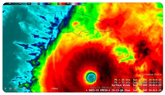
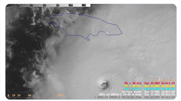
1-minute #GOES19/#GOESEast Infrared and Visible images revealed the well-defined eye of Hurricane #Melissa, which reached Category 4 intensity southeast of Jamaica at this morning at 1200 UTC. Low-altitude mesovortices within the eye were apparent in the Visible imagery.
(screenshots from the video)
12:45 PM · Oct 26, 2025
UW-Madison CIMSS
@UWCIMSS
1-minute #GOES19/#GOESEast Infrared and Visible images revealed the well-defined eye of Hurricane #Melissa, which reached Category 4 intensity southeast of Jamaica at this morning at 1200 UTC. Low-altitude mesovortices within the eye were apparent in the Visible imagery.
(screenshots from the video)
12:45 PM · Oct 26, 2025
sharon sanders
Editor-in-Chief & President
Historic Hurricane Melissa become a Category 5 and heads to Jamaica
https://www.youtube.com/watch?v=S7TCCtB-zF4
https://www.youtube.com/watch?v=S7TCCtB-zF4
Pathfinder
Editor, Senior Moderator
Pathfinder
Editor, Senior Moderator
News
JAM
|Oct 27, 2025
‘You cannot bet against Melissa’, Desmond McKenzie warns
Ainsworth Morris / Our Today
...
While speaking at a press conference hosted by the Government on Sunday (October 26) at the Office of Disaster Preparedness and Emergency Management (ODPEM), McKenzie passionately said the critical communities known themselves, such as Rocky Point in Clarendon, Portland Cottage, Bamboo River in St. Thomas, New Haven, Riverton City and Taylor Lands.
“If anybody believes being stubborn helps, well, that is their funeral. This is one bet you cannot win. You cannot bet against Melissa. Don’t do it, because you can’t win… There is nothing more we can do as a Government, but to beg and beseech persons to heed the warning,” McKenzie said.
“And if it will help, I will go on my knees,” he said.
His appeal comes as residents of Port Royal defied evacuation recommendations after Kingston Mayor Andrew Swaby personally visited the vulnerable town with two Jamaica Urban Transit Company (JUTC) buses that left with only one occupant.
...
As a “praying country”, McKenzie pleaded for more prayers as only “God knows where this journey will end”.
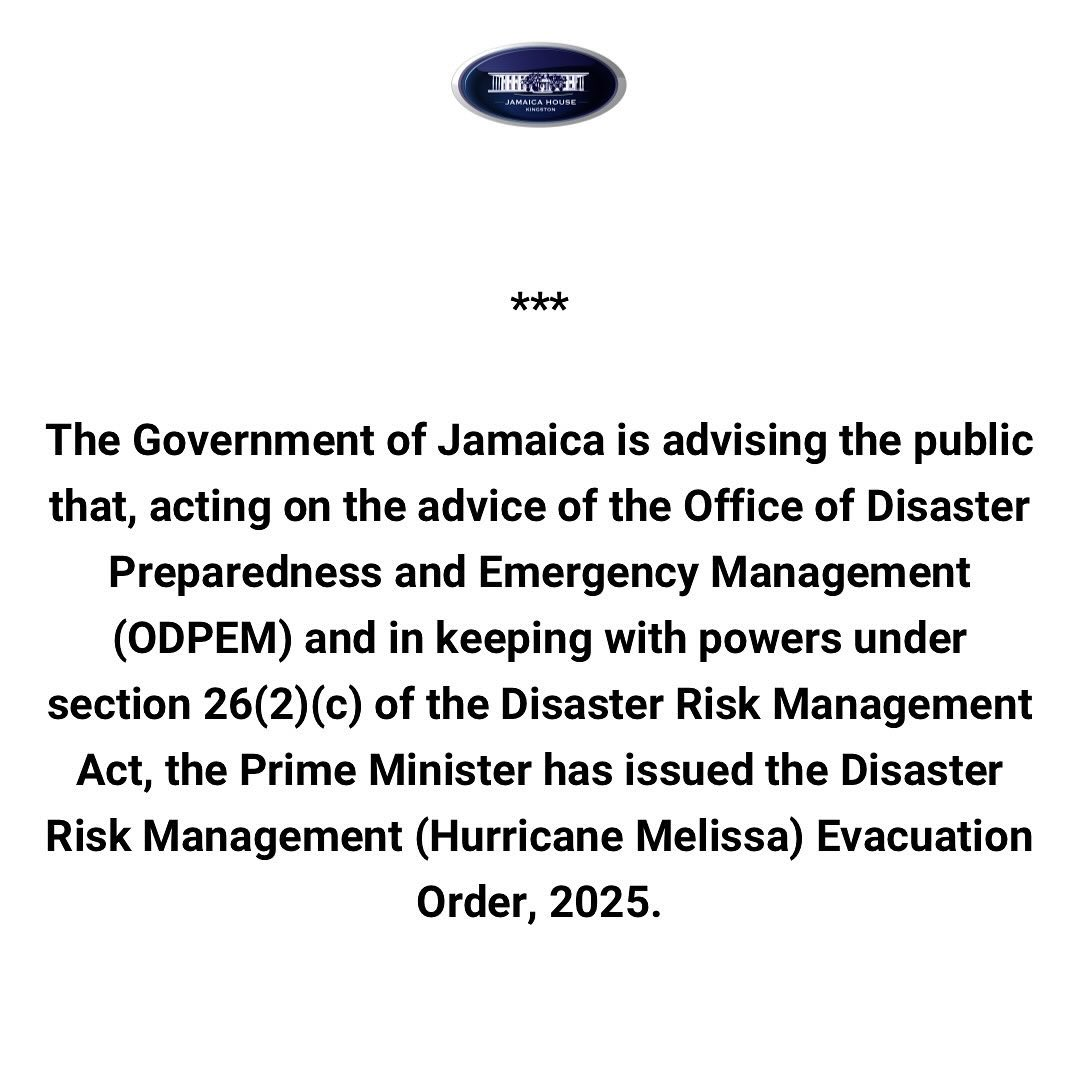
The Prime Minister Andrew Holness-led government later issued a mandatory evacuation order for seven flood-prone Jamaican communities.
https://our.today/you-cannot-bet-against-melissa-desmond-mckenzie-warns/
---------------------------------------------------------------
Local Gov't Ja
@LocalGovJa
Mandatory evacuation orders for specified vulnerable communities is now in effect. #HurricaneMelissa
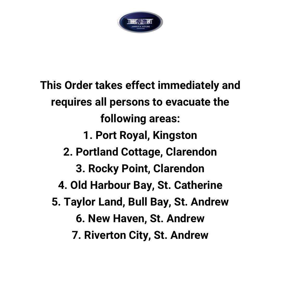
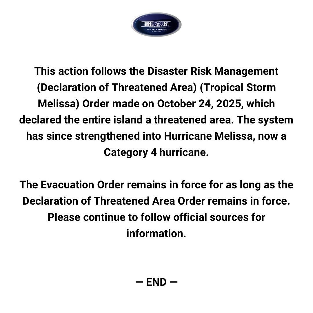
8:08 PM · Oct 26, 2025
JAM
|Oct 27, 2025
‘You cannot bet against Melissa’, Desmond McKenzie warns
Ainsworth Morris / Our Today
...
While speaking at a press conference hosted by the Government on Sunday (October 26) at the Office of Disaster Preparedness and Emergency Management (ODPEM), McKenzie passionately said the critical communities known themselves, such as Rocky Point in Clarendon, Portland Cottage, Bamboo River in St. Thomas, New Haven, Riverton City and Taylor Lands.
“If anybody believes being stubborn helps, well, that is their funeral. This is one bet you cannot win. You cannot bet against Melissa. Don’t do it, because you can’t win… There is nothing more we can do as a Government, but to beg and beseech persons to heed the warning,” McKenzie said.
“And if it will help, I will go on my knees,” he said.
His appeal comes as residents of Port Royal defied evacuation recommendations after Kingston Mayor Andrew Swaby personally visited the vulnerable town with two Jamaica Urban Transit Company (JUTC) buses that left with only one occupant.
...
As a “praying country”, McKenzie pleaded for more prayers as only “God knows where this journey will end”.
The Prime Minister Andrew Holness-led government later issued a mandatory evacuation order for seven flood-prone Jamaican communities.
https://our.today/you-cannot-bet-against-melissa-desmond-mckenzie-warns/
---------------------------------------------------------------
Local Gov't Ja
@LocalGovJa
Mandatory evacuation orders for specified vulnerable communities is now in effect. #HurricaneMelissa
8:08 PM · Oct 26, 2025
Pathfinder
Editor, Senior Moderator
Hurricane Melissa Public Advisory
[TABLE="border: 0, cellpadding: 0, cellspacing: 0"]
[TR]
[TD]Home Public Adv Fcst Adv Discussion Wind Probs Graphics Archive
Español: Aviso Publico Discusión
[/TD]
[/TR]
[/TABLE]
000
WTNT33 KNHC 271147
TCPAT3
BULLETIN
Hurricane Melissa Intermediate Advisory Number 24A
NWS National Hurricane Center Miami FL AL132025
800 AM EDT Mon Oct 27 2025
...NOAA AND AIR FORCE RESERVE HURRICANE HUNTERS INVESTIGATING
CATEGORY 5 MELISSA...
...DESTRUCTIVE WINDS AND STORM SURGE AND CATASTROPHIC FLOODING WILL
WORSEN ON JAMAICA THROUGH THE DAY AND INTO TONIGHT...
SUMMARY OF 800 AM EDT...1200 UTC...INFORMATION
----------------------------------------------
LOCATION...16.4N 78.0W
ABOUT 135 MI...220 KM SW OF KINGSTON JAMAICA
ABOUT 320 MI...515 KM SW OF GUANTANAMO CUBA
MAXIMUM SUSTAINED WINDS...160 MPH...260 KM/H
PRESENT MOVEMENT...W OR 275 DEGREES AT 3 MPH...6 KM/H
MINIMUM CENTRAL PRESSURE...913 MB...26.96 INCHES
WATCHES AND WARNINGS
--------------------
CHANGES WITH THIS ADVISORY:
None.
SUMMARY OF WATCHES AND WARNINGS IN EFFECT:
A Hurricane Warning is in effect for...
* Jamaica
* Cuban provinces of Granma, Santiago de Cuba, Guantanamo, and
Holguin.
A Hurricane Watch is in effect for...
* Southeastern and central Bahamas
* Turks and Caicos Islands
A Tropical Storm Warning is in effect for...
* Haiti
* Cuban province of Las Tunas
A Hurricane Warning means that hurricane conditions are expected
somewhere within the warning area. A warning is typically issued 36
hours before the anticipated first occurrence of
tropical-storm-force winds, conditions that make outside
preparations difficult or dangerous. Preparations to protect life
and property should be complete in Jamaica and rushed to completion
in Cuba.
A Hurricane Watch means that hurricane conditions are possible
within the watch area. A watch is typically issued 48 hours
before the anticipated first occurrence of tropical-storm-force
winds, conditions that make outside preparations difficult or
dangerous.
A Tropical Storm Warning means that tropical storm conditions are
expected somewhere within the warning area within 36 hours.
Interests in Bermuda should monitor the progress of Melissa.
For storm information specific to your area, please monitor
products issued by your national meteorological service.
DISCUSSION AND OUTLOOK
----------------------
At 800 AM EDT (1200 UTC), the distinct eye of Hurricane Melissa was
located near latitude 16.4 North, longitude 78.0 West. Melissa is
moving toward the west near 3 mph (6 km/h). A slow turn toward the
northwest and north is expected today and tonight, followed by a
northeastward acceleration beginning on Tuesday and continuing
through at least Thursday. On the forecast track, the core of
Melissa is expected to move near or over Jamaica tonight and
Tuesday, across southeastern Cuba Tuesday night, and across the
southeastern Bahamas on Wednesday.
Reports from NOAA and Air Force Reserve Hurricane Hunter aircraft
indicate that maximum sustained winds are near 160 mph (260 km/h)
with higher gusts. Melissa is a category 5 hurricane on the
Saffir-Simpson Hurricane Wind Scale. Some additional strengthening
is forecast today, with fluctuations in intensity likely before
Melissa makes landfall on Jamaica early Tuesday. Melissa is
expected to reach Jamaica and southeastern Cuba as a powerful major
hurricane, and will still be at hurricane strength when it moves
across the southeastern Bahamas.
Hurricane-force winds extend outward up to 30 miles (45 km) from
the center and tropical-storm-force winds extend outward up to 195
miles (315 km).
The minimum central pressure from the Hurricane Hunter aircraft
data is 913 mb (26.96 inches).
HAZARDS AFFECTING LAND
----------------------
Key messages for Melissa can be found in the Tropical Cyclone
Discussion under AWIPS header MIATCDAT3 and WMO header WTNT43 KNHC.
WIND: Tropical storm conditions are occuring in Jamaica, and
destructive hurricane conditions are expected to begin tonight or
early Tuesday. Wind speeds atop and on the windward sides of hills
and mountains could be up to 30 percent stronger than the
near-surface winds indicated in this advisory, and in some elevated
locations could be even greater.
Tropical storm conditions are expected to begin in eastern Cuba on
Tuesday, with hurricane conditions expected to begin in the
hurricane warning area by Tuesday evening. Tropical storm conditions
are expected in Haiti late Tuesday and Wednesday.
Tropical storm and hurricane conditions are possible in the
southeastern and central Bahamas, as well as the Turks and Caicos
Islands, on Wednesday.
RAINFALL: Melissa is expected to bring rainfall of 15 to 30 inches
to portions of Jamaica and additional rainfall of 8 to 16 inches for
southern Hispaniola through Wednesday, with storm total local maxima
of 40 inches possible. Catastrophic flash flooding and numerous
landslides are likely.
For eastern Cuba, storm total rainfall of 10 to 15 inches, with
local amounts to 20 inches, is expected today through Wednesday
resulting in life-threatening and potentially catastrophic flash
flooding with numerous landslides.
Over the Southeast Bahamas, total rainfall of 4 to 8 inches is
expected Tuesday into Wednesday resulting in areas of flash
flooding.
For a complete depiction of forecast rainfall associated with
Melissa, please see the National Weather Service Storm Total
Rainfall Graphic, available at
hurricanes.gov/graphics_at3.shtml?rainqpf
STORM SURGE: A life-threatening storm surge is likely along the
south coast of Jamaica tonight and on Tuesday. Peak storm surge
heights could reach 9 to 13 feet above ground level, near and to the
east of where the center of Melissa makes landfall. This storm surge
will be accompanied by large and destructive waves.
There is a potential for significant storm surge along the southeast
coast of Cuba late Tuesday or Wednesday. Peak storm surge heights
could reach 6 to 9 feet above normal tide levels, near and to the
east of where the center of Melissa makes landfall. This storm surge
will be accompanied by large and destructive waves.
Storm surge is possible in the southeastern Bahamas and Turks and
Caicos Islands on Wednesday.
SURF: Swells generated by Melissa are expected to affect portions of
Hispaniola, Jamaica, eastern Cuba, and the Cayman Islands during the
next several days, and the Bahamas, the Turks and Caicos Islands,
and Bermuda later this week. These swells are likely to cause
life-threatening surf and rip current conditions. Please consult
products from your local weather office.
NEXT ADVISORY
-------------
Next complete advisory at 1100 AM EDT.
$$
Forecaster Beven
https://www.nhc.noaa.gov/text/refresh/MIATCPAT3+shtml/271147.shtml
----------------------------------------------------------
Hurricane Melissa Forecast Discussion
[TABLE="border: 0, cellpadding: 0, cellspacing: 0"]
[TR]
[TD]Home Public Adv Fcst Adv Discussion Wind Probs Graphics Archive
Español: Aviso Publico Discusión
[/TD]
[/TR]
[/TABLE]
000
WTNT43 KNHC 270851
TCDAT3
Hurricane Melissa Discussion Number 24
NWS National Hurricane Center Miami FL AL132025
500 AM EDT Mon Oct 27 2025
An ongoing Air Force Reserve Hurricane Hunter aircraft has been
measuring progressively higher winds and lower central pressures
during each of its passes through Melissa's eye. On the third and
final pass, the crew measured a peak flight-level wind of 154 kt and
a central pressure of 917 mb. This flight-level wind reduces to
about 140 kt, making Melissa a category 5 hurricane. The
hurricane's eye is 10 n mi wide with a temperature of 20 degrees
Celsius, while the surrounding convection has cloud top temperatures
as cold as -86 degrees Celsius.
Melissa appears to be gaining some latitude again, but the 12-hour
average motion is westward (275 degrees) at 3 kt. A painstakingly
slow turn toward the northwest and north is expected during the
next 24 hours, and Melissa is forecast to make landfall on the
south coast of Jamaica Tuesday morning and emerge off the north
coast by Tuesday afternoon. A trough moving across the
southeastern United States is then expected to cause Melissa to
turn northeastward and accelerate, crossing southeastern Cuba and
the southeastern Bahamas Tuesday night and Wednesday, and then
reaching the vicinity of Bermuda Thursday night. The part of the
forecast track while Melissa is over the western Atlantic has been
adjusted a bit westward, following the latest Google DeepMind and
European model solutions.
Some additional strengthening is possible during the next 12 to 24
hours while Melissa is south of Jamaica over waters of high oceanic
heat content and in an environment of relatively low wind shear.
Fluctuations in intensity are also possible during this period due
to internal dynamics related to eyewall replacements, which are
generally difficult to forecast. There's really no practical
difference in Melissa making landfall in Jamaica at category 4 or 5
intensity, since both categories can produce catastrophic wind
damage. In addition, winds in the mountains of Jamaica are likely
to be higher than the winds at sea level, and are likely to add to
the seriousness of the situation. Although interaction with
Jamaica will lead to some weakening, Melissa is expected to reach
southeastern Cuba as a major hurricane, and will also move across
the southeastern Bahamas and be near Bermuda as a hurricane. Some
of the guidance shows a flatlining of the intensity while Melissa
is moving over the southwestern Atlantic, and the NHC forecast has
been bumped up during that time accordingly.
Key Messages:
1. Jamaica: Do not venture out of your safe shelter. Catastrophic
and life-threatening flash flooding and numerous landslides are
likely today through Tuesday. Destructive winds, especially in the
mountains, will begin by this evening, leading to extensive
infrastructural damage, long-lasting power and communication
outages, and isolated communities. Life-threatening storm surge and
damaging waves are expected along the southern coast through
Tuesday.
2. Haiti and the Dominican Republic: Catastrophic and
life-threatening flash flooding and landslides are expected across
southwestern Haiti and southern portions of the Dominican Republic
through midweek. In Haiti, extensive infrastructural damage and
isolation of communities is likely. Tropical storm conditions are
expected late Tuesday and Wednesday.
3. Eastern Cuba: Heavy rainfall with life-threatening and
potentially catastrophic flash flooding and landslides is expected
beginning today. Life-threatening storm surge and damaging winds are
expected late Tuesday and Tuesday night. Preparations should be
rushed to completion.
4. Southeast Bahamas and the Turks and Caicos: Hurricane conditions,
life-threatening storm surge, and heavy rainfall are possible on
Wednesday. Residents should follow advice given by local officials
and be sure to have preparations complete by Tuesday night.
FORECAST POSITIONS AND MAX WINDS
INIT 27/0900Z 16.4N 77.8W 140 KT 160 MPH
12H 27/1800Z 16.6N 78.1W 145 KT 165 MPH
24H 28/0600Z 17.3N 78.1W 140 KT 160 MPH
36H 28/1800Z 18.5N 77.3W 115 KT 130 MPH...NORTH COAST OF JAMAICA
48H 29/0600Z 20.1N 76.0W 105 KT 120 MPH...OVER SE CUBA
60H 29/1800Z 22.1N 74.4W 90 KT 105 MPH...NEAR SE BAHAMAS
72H 30/0600Z 24.7N 72.3W 85 KT 100 MPH
96H 31/0600Z 32.3N 65.1W 80 KT 90 MPH...NEAR BERMUDA
120H 01/0600Z 41.4N 53.5W 60 KT 70 MPH...POST-TROP/EXTRATROP
$$
Forecaster Berg/Hagen
https://www.nhc.noaa.gov/text/refresh/MIATCDAT3+shtml/270851.shtml?
-------------------------------------------------
(screenshots)
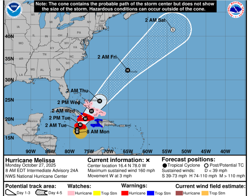
https://www.nhc.noaa.gov/refresh/graphics_at3+shtml/271147.shtml?cone#contents
-----------------------------------------------------------------------------------------------------------------
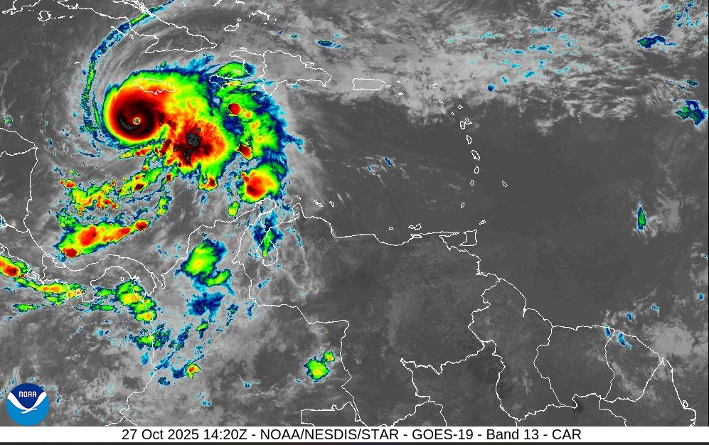
https://cdn.star.nesdis.noaa.gov/GOES19/ABI/SECTOR/car/13/1000x1000.jpg
---------------------------------------------------------------------------------------------
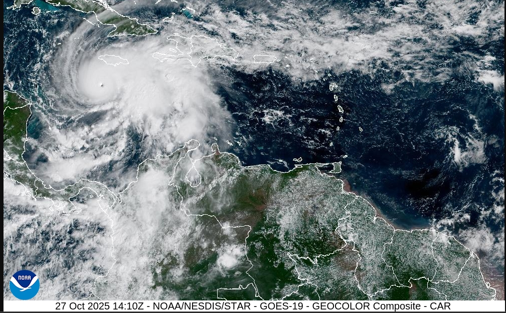
https://cdn.star.nesdis.noaa.gov/GOES19/ABI/SECTOR/car/GEOCOLOR/1000x1000.jpg
[TABLE="border: 0, cellpadding: 0, cellspacing: 0"]
[TR]
[TD]Home Public Adv Fcst Adv Discussion Wind Probs Graphics Archive
Español: Aviso Publico Discusión
[/TD]
[/TR]
[/TABLE]
000
WTNT33 KNHC 271147
TCPAT3
BULLETIN
Hurricane Melissa Intermediate Advisory Number 24A
NWS National Hurricane Center Miami FL AL132025
800 AM EDT Mon Oct 27 2025
...NOAA AND AIR FORCE RESERVE HURRICANE HUNTERS INVESTIGATING
CATEGORY 5 MELISSA...
...DESTRUCTIVE WINDS AND STORM SURGE AND CATASTROPHIC FLOODING WILL
WORSEN ON JAMAICA THROUGH THE DAY AND INTO TONIGHT...
SUMMARY OF 800 AM EDT...1200 UTC...INFORMATION
----------------------------------------------
LOCATION...16.4N 78.0W
ABOUT 135 MI...220 KM SW OF KINGSTON JAMAICA
ABOUT 320 MI...515 KM SW OF GUANTANAMO CUBA
MAXIMUM SUSTAINED WINDS...160 MPH...260 KM/H
PRESENT MOVEMENT...W OR 275 DEGREES AT 3 MPH...6 KM/H
MINIMUM CENTRAL PRESSURE...913 MB...26.96 INCHES
WATCHES AND WARNINGS
--------------------
CHANGES WITH THIS ADVISORY:
None.
SUMMARY OF WATCHES AND WARNINGS IN EFFECT:
A Hurricane Warning is in effect for...
* Jamaica
* Cuban provinces of Granma, Santiago de Cuba, Guantanamo, and
Holguin.
A Hurricane Watch is in effect for...
* Southeastern and central Bahamas
* Turks and Caicos Islands
A Tropical Storm Warning is in effect for...
* Haiti
* Cuban province of Las Tunas
A Hurricane Warning means that hurricane conditions are expected
somewhere within the warning area. A warning is typically issued 36
hours before the anticipated first occurrence of
tropical-storm-force winds, conditions that make outside
preparations difficult or dangerous. Preparations to protect life
and property should be complete in Jamaica and rushed to completion
in Cuba.
A Hurricane Watch means that hurricane conditions are possible
within the watch area. A watch is typically issued 48 hours
before the anticipated first occurrence of tropical-storm-force
winds, conditions that make outside preparations difficult or
dangerous.
A Tropical Storm Warning means that tropical storm conditions are
expected somewhere within the warning area within 36 hours.
Interests in Bermuda should monitor the progress of Melissa.
For storm information specific to your area, please monitor
products issued by your national meteorological service.
DISCUSSION AND OUTLOOK
----------------------
At 800 AM EDT (1200 UTC), the distinct eye of Hurricane Melissa was
located near latitude 16.4 North, longitude 78.0 West. Melissa is
moving toward the west near 3 mph (6 km/h). A slow turn toward the
northwest and north is expected today and tonight, followed by a
northeastward acceleration beginning on Tuesday and continuing
through at least Thursday. On the forecast track, the core of
Melissa is expected to move near or over Jamaica tonight and
Tuesday, across southeastern Cuba Tuesday night, and across the
southeastern Bahamas on Wednesday.
Reports from NOAA and Air Force Reserve Hurricane Hunter aircraft
indicate that maximum sustained winds are near 160 mph (260 km/h)
with higher gusts. Melissa is a category 5 hurricane on the
Saffir-Simpson Hurricane Wind Scale. Some additional strengthening
is forecast today, with fluctuations in intensity likely before
Melissa makes landfall on Jamaica early Tuesday. Melissa is
expected to reach Jamaica and southeastern Cuba as a powerful major
hurricane, and will still be at hurricane strength when it moves
across the southeastern Bahamas.
Hurricane-force winds extend outward up to 30 miles (45 km) from
the center and tropical-storm-force winds extend outward up to 195
miles (315 km).
The minimum central pressure from the Hurricane Hunter aircraft
data is 913 mb (26.96 inches).
HAZARDS AFFECTING LAND
----------------------
Key messages for Melissa can be found in the Tropical Cyclone
Discussion under AWIPS header MIATCDAT3 and WMO header WTNT43 KNHC.
WIND: Tropical storm conditions are occuring in Jamaica, and
destructive hurricane conditions are expected to begin tonight or
early Tuesday. Wind speeds atop and on the windward sides of hills
and mountains could be up to 30 percent stronger than the
near-surface winds indicated in this advisory, and in some elevated
locations could be even greater.
Tropical storm conditions are expected to begin in eastern Cuba on
Tuesday, with hurricane conditions expected to begin in the
hurricane warning area by Tuesday evening. Tropical storm conditions
are expected in Haiti late Tuesday and Wednesday.
Tropical storm and hurricane conditions are possible in the
southeastern and central Bahamas, as well as the Turks and Caicos
Islands, on Wednesday.
RAINFALL: Melissa is expected to bring rainfall of 15 to 30 inches
to portions of Jamaica and additional rainfall of 8 to 16 inches for
southern Hispaniola through Wednesday, with storm total local maxima
of 40 inches possible. Catastrophic flash flooding and numerous
landslides are likely.
For eastern Cuba, storm total rainfall of 10 to 15 inches, with
local amounts to 20 inches, is expected today through Wednesday
resulting in life-threatening and potentially catastrophic flash
flooding with numerous landslides.
Over the Southeast Bahamas, total rainfall of 4 to 8 inches is
expected Tuesday into Wednesday resulting in areas of flash
flooding.
For a complete depiction of forecast rainfall associated with
Melissa, please see the National Weather Service Storm Total
Rainfall Graphic, available at
hurricanes.gov/graphics_at3.shtml?rainqpf
STORM SURGE: A life-threatening storm surge is likely along the
south coast of Jamaica tonight and on Tuesday. Peak storm surge
heights could reach 9 to 13 feet above ground level, near and to the
east of where the center of Melissa makes landfall. This storm surge
will be accompanied by large and destructive waves.
There is a potential for significant storm surge along the southeast
coast of Cuba late Tuesday or Wednesday. Peak storm surge heights
could reach 6 to 9 feet above normal tide levels, near and to the
east of where the center of Melissa makes landfall. This storm surge
will be accompanied by large and destructive waves.
Storm surge is possible in the southeastern Bahamas and Turks and
Caicos Islands on Wednesday.
SURF: Swells generated by Melissa are expected to affect portions of
Hispaniola, Jamaica, eastern Cuba, and the Cayman Islands during the
next several days, and the Bahamas, the Turks and Caicos Islands,
and Bermuda later this week. These swells are likely to cause
life-threatening surf and rip current conditions. Please consult
products from your local weather office.
NEXT ADVISORY
-------------
Next complete advisory at 1100 AM EDT.
$$
Forecaster Beven
https://www.nhc.noaa.gov/text/refresh/MIATCPAT3+shtml/271147.shtml
----------------------------------------------------------
Hurricane Melissa Forecast Discussion
[TABLE="border: 0, cellpadding: 0, cellspacing: 0"]
[TR]
[TD]Home Public Adv Fcst Adv Discussion Wind Probs Graphics Archive
Español: Aviso Publico Discusión
[/TD]
[/TR]
[/TABLE]
000
WTNT43 KNHC 270851
TCDAT3
Hurricane Melissa Discussion Number 24
NWS National Hurricane Center Miami FL AL132025
500 AM EDT Mon Oct 27 2025
An ongoing Air Force Reserve Hurricane Hunter aircraft has been
measuring progressively higher winds and lower central pressures
during each of its passes through Melissa's eye. On the third and
final pass, the crew measured a peak flight-level wind of 154 kt and
a central pressure of 917 mb. This flight-level wind reduces to
about 140 kt, making Melissa a category 5 hurricane. The
hurricane's eye is 10 n mi wide with a temperature of 20 degrees
Celsius, while the surrounding convection has cloud top temperatures
as cold as -86 degrees Celsius.
Melissa appears to be gaining some latitude again, but the 12-hour
average motion is westward (275 degrees) at 3 kt. A painstakingly
slow turn toward the northwest and north is expected during the
next 24 hours, and Melissa is forecast to make landfall on the
south coast of Jamaica Tuesday morning and emerge off the north
coast by Tuesday afternoon. A trough moving across the
southeastern United States is then expected to cause Melissa to
turn northeastward and accelerate, crossing southeastern Cuba and
the southeastern Bahamas Tuesday night and Wednesday, and then
reaching the vicinity of Bermuda Thursday night. The part of the
forecast track while Melissa is over the western Atlantic has been
adjusted a bit westward, following the latest Google DeepMind and
European model solutions.
Some additional strengthening is possible during the next 12 to 24
hours while Melissa is south of Jamaica over waters of high oceanic
heat content and in an environment of relatively low wind shear.
Fluctuations in intensity are also possible during this period due
to internal dynamics related to eyewall replacements, which are
generally difficult to forecast. There's really no practical
difference in Melissa making landfall in Jamaica at category 4 or 5
intensity, since both categories can produce catastrophic wind
damage. In addition, winds in the mountains of Jamaica are likely
to be higher than the winds at sea level, and are likely to add to
the seriousness of the situation. Although interaction with
Jamaica will lead to some weakening, Melissa is expected to reach
southeastern Cuba as a major hurricane, and will also move across
the southeastern Bahamas and be near Bermuda as a hurricane. Some
of the guidance shows a flatlining of the intensity while Melissa
is moving over the southwestern Atlantic, and the NHC forecast has
been bumped up during that time accordingly.
Key Messages:
1. Jamaica: Do not venture out of your safe shelter. Catastrophic
and life-threatening flash flooding and numerous landslides are
likely today through Tuesday. Destructive winds, especially in the
mountains, will begin by this evening, leading to extensive
infrastructural damage, long-lasting power and communication
outages, and isolated communities. Life-threatening storm surge and
damaging waves are expected along the southern coast through
Tuesday.
2. Haiti and the Dominican Republic: Catastrophic and
life-threatening flash flooding and landslides are expected across
southwestern Haiti and southern portions of the Dominican Republic
through midweek. In Haiti, extensive infrastructural damage and
isolation of communities is likely. Tropical storm conditions are
expected late Tuesday and Wednesday.
3. Eastern Cuba: Heavy rainfall with life-threatening and
potentially catastrophic flash flooding and landslides is expected
beginning today. Life-threatening storm surge and damaging winds are
expected late Tuesday and Tuesday night. Preparations should be
rushed to completion.
4. Southeast Bahamas and the Turks and Caicos: Hurricane conditions,
life-threatening storm surge, and heavy rainfall are possible on
Wednesday. Residents should follow advice given by local officials
and be sure to have preparations complete by Tuesday night.
FORECAST POSITIONS AND MAX WINDS
INIT 27/0900Z 16.4N 77.8W 140 KT 160 MPH
12H 27/1800Z 16.6N 78.1W 145 KT 165 MPH
24H 28/0600Z 17.3N 78.1W 140 KT 160 MPH
36H 28/1800Z 18.5N 77.3W 115 KT 130 MPH...NORTH COAST OF JAMAICA
48H 29/0600Z 20.1N 76.0W 105 KT 120 MPH...OVER SE CUBA
60H 29/1800Z 22.1N 74.4W 90 KT 105 MPH...NEAR SE BAHAMAS
72H 30/0600Z 24.7N 72.3W 85 KT 100 MPH
96H 31/0600Z 32.3N 65.1W 80 KT 90 MPH...NEAR BERMUDA
120H 01/0600Z 41.4N 53.5W 60 KT 70 MPH...POST-TROP/EXTRATROP
$$
Forecaster Berg/Hagen
https://www.nhc.noaa.gov/text/refresh/MIATCDAT3+shtml/270851.shtml?
-------------------------------------------------
(screenshots)
https://www.nhc.noaa.gov/refresh/graphics_at3+shtml/271147.shtml?cone#contents
-----------------------------------------------------------------------------------------------------------------
https://cdn.star.nesdis.noaa.gov/GOES19/ABI/SECTOR/car/13/1000x1000.jpg
---------------------------------------------------------------------------------------------
https://cdn.star.nesdis.noaa.gov/GOES19/ABI/SECTOR/car/GEOCOLOR/1000x1000.jpg
Pathfinder
Editor, Senior Moderator
Hurricane Melissa Public Advisory
[TABLE="border: 0, cellpadding: 0, cellspacing: 0"]
[TR]
[TD]Home Public Adv Fcst Adv Discussion Wind Probs Graphics Archive
Español: Aviso Publico Discusión
[/TD]
[/TR]
[/TABLE]
000
WTNT33 KNHC 271447
TCPAT3
BULLETIN
Hurricane Melissa Advisory Number 25
NWS National Hurricane Center Miami FL AL132025
1100 AM EDT Mon Oct 27 2025
...CATEGORY 5 MELISSA EXPECTED TO TURN NORTHWARD LATER TODAY OR
TONIGHT...
...CATASTROPHIC AND LIFE-THREATENING WINDS, FLOODING, AND STORM
SURGE EXPECTED ON JAMAICA TONIGHT AND EARLY TUESDAY...
SUMMARY OF 1100 AM EDT...1500 UTC...INFORMATION
-----------------------------------------------
LOCATION...16.4N 78.2W
ABOUT 145 MI...230 KM SW OF KINGSTON JAMAICA
ABOUT 330 MI...530 KM SW OF GUANTANAMO CUBA
MAXIMUM SUSTAINED WINDS...165 MPH...270 KM/H
PRESENT MOVEMENT...W OR 270 DEGREES AT 3 MPH...6 KM/H
MINIMUM CENTRAL PRESSURE...908 MB...26.82 INCHES
...
Maximum sustained winds are near 165 mph (270 km/h) with higher
gusts. Melissa is a category 5 hurricane on the Saffir-Simpson
Hurricane Wind Scale. Some fluctuations in intensity are likely
before Melissa makes landfall on Jamaica on Tuesday. However,
Melissa is expected to reach Jamaica and southeastern Cuba as an
extremely powerful major hurricane, and will still be at hurricane
strength when it moves across the southeastern Bahamas.
Hurricane-force winds extend outward up to 30 miles (45 km) from the
center and tropical-storm-force winds extend outward up to 195 miles
(315 km).
...
https://www.nhc.noaa.gov/text/refresh/MIATCPAT3+shtml/271447.shtml?
[TABLE="border: 0, cellpadding: 0, cellspacing: 0"]
[TR]
[TD]Home Public Adv Fcst Adv Discussion Wind Probs Graphics Archive
Español: Aviso Publico Discusión
[/TD]
[/TR]
[/TABLE]
000
WTNT33 KNHC 271447
TCPAT3
BULLETIN
Hurricane Melissa Advisory Number 25
NWS National Hurricane Center Miami FL AL132025
1100 AM EDT Mon Oct 27 2025
...CATEGORY 5 MELISSA EXPECTED TO TURN NORTHWARD LATER TODAY OR
TONIGHT...
...CATASTROPHIC AND LIFE-THREATENING WINDS, FLOODING, AND STORM
SURGE EXPECTED ON JAMAICA TONIGHT AND EARLY TUESDAY...
SUMMARY OF 1100 AM EDT...1500 UTC...INFORMATION
-----------------------------------------------
LOCATION...16.4N 78.2W
ABOUT 145 MI...230 KM SW OF KINGSTON JAMAICA
ABOUT 330 MI...530 KM SW OF GUANTANAMO CUBA
MAXIMUM SUSTAINED WINDS...165 MPH...270 KM/H
PRESENT MOVEMENT...W OR 270 DEGREES AT 3 MPH...6 KM/H
MINIMUM CENTRAL PRESSURE...908 MB...26.82 INCHES
...
Maximum sustained winds are near 165 mph (270 km/h) with higher
gusts. Melissa is a category 5 hurricane on the Saffir-Simpson
Hurricane Wind Scale. Some fluctuations in intensity are likely
before Melissa makes landfall on Jamaica on Tuesday. However,
Melissa is expected to reach Jamaica and southeastern Cuba as an
extremely powerful major hurricane, and will still be at hurricane
strength when it moves across the southeastern Bahamas.
Hurricane-force winds extend outward up to 30 miles (45 km) from the
center and tropical-storm-force winds extend outward up to 195 miles
(315 km).
...
https://www.nhc.noaa.gov/text/refresh/MIATCPAT3+shtml/271447.shtml?
sharon sanders
Editor-in-Chief & President
h/t Pathfinder
Hurricane Melissa Public Advisory
[TABLE="border: 0, cellpadding: 0, cellspacing: 0"]
[TR]
[TD]Home Public Adv Fcst Adv Discussion Wind Probs Graphics Archive
Español: Aviso Publico Discusión
[/TD]
[/TR]
[/TABLE]
000
WTNT33 KNHC 271733
TCPAT3
BULLETIN
Hurricane Melissa Intermediate Advisory Number 25A
NWS National Hurricane Center Miami FL AL132025
200 PM EDT Mon Oct 27 2025
...CATEGORY 5 MELISSA MOVING SLOWLY WEST-NORTHWESTWARD AND
EXPECTED TO TURN NORTHWARD LATER TODAY...
...CATASTROPHIC AND LIFE-THREATENING WINDS, FLOODING, AND STORM
SURGE EXPECTED ON JAMAICA TONIGHT AND EARLY TUESDAY...
SUMMARY OF 200 PM EDT...1800 UTC...INFORMATION
----------------------------------------------
LOCATION...16.5N 78.3W
ABOUT 145 MI...230 KM SW OF KINGSTON JAMAICA
ABOUT 325 MI...525 KM SW OF GUANTANAMO CUBA
MAXIMUM SUSTAINED WINDS...175 MPH...280 KM/H
PRESENT MOVEMENT...WNW OR 285 DEGREES AT 3 MPH...6 KM/H
MINIMUM CENTRAL PRESSURE...906 MB...26.76 INCHES
WATCHES AND WARNINGS
--------------------
CHANGES WITH THIS ADVISORY:
None.
SUMMARY OF WATCHES AND WARNINGS IN EFFECT:
A Hurricane Warning is in effect for...
* Jamaica
* Cuban provinces of Granma, Santiago de Cuba, Guantanamo, and
Holguin.
A Hurricane Watch is in effect for...
* Southeastern and central Bahamas
* Turks and Caicos Islands
A Tropical Storm Warning is in effect for...
* Haiti
* Cuban province of Las Tunas
A Hurricane Warning means that hurricane conditions are expected
somewhere within the warning area. A warning is typically issued
36 hours before the anticipated first occurrence of
tropical-storm-force winds, conditions that make outside
preparations difficult or dangerous. Preparations to protect life
and property should be complete in Jamaica and rushed to completion
in Cuba.
A Hurricane Watch means that hurricane conditions are possible
within the watch area. A watch is typically issued 48 hours
before the anticipated first occurrence of tropical-storm-force
winds, conditions that make outside preparations difficult or
dangerous.
A Tropical Storm Warning means that tropical storm conditions are
expected somewhere within the warning area within 36 hours.
A Hurricane Warning may be required for portions of the Bahamas and
the Turks and Caicos islands later today or tonight. Interests in
Bermuda should also monitor the progress of Melissa.
For storm information specific to your area, please monitor
products issued by your national meteorological service.
DISCUSSION AND OUTLOOK
----------------------
At 200 PM EDT (1800 UTC), the eye of Hurricane Melissa was
located near latitude 16.5 North, longitude 78.3 West. Melissa is
moving toward the west-northwest near 3 mph (6 km/h). A slow turn
toward the northwest and north is expected later today, followed by
a turn toward the northeast and a faster forward speed on Tuesday.
A northeastward motion is expected on Wednesday and Thursday. On
the forecast track, the core of Melissa is expected to move over
Jamaica tonight and early Tuesday, across southeastern Cuba Tuesday
night, and across the southeastern Bahamas on Wednesday.
Reports from an Air force Reserve Hurricane Hunter aircraft
indicate that maximum sustained winds are now near 175 mph
(280 km/h) with higher gusts. Melissa is a category 5 hurricane on
the Saffir-Simpson Hurricane Wind Scale. Some fluctuations in
intensity are likely before Melissa makes landfall on Jamaica on
Tuesday. However, Melissa is expected to reach Jamaica and
southeastern Cuba as an extremely powerful major hurricane, and will
still be at hurricane strength when it moves across the southeastern
Bahamas.
Hurricane-force winds extend outward up to 30 miles (45 km) from
the center and tropical-storm-force winds extend outward up to 195
miles (315 km).
The minimum central pressure estimated from the latest Air Force
Reserve Hurricane Hunter aircraft data is 906 mb (26.76 inches).
HAZARDS AFFECTING LAND
----------------------
Key messages for Melissa can be found in the Tropical Cyclone
Discussion under AWIPS header MIATCDAT3 and WMO header WTNT43 KNHC.
WIND: Tropical storm conditions are occurring in Jamaica, and
catastrophic and life-threatening hurricane-force wind conditions
are expected to begin tonight and continue into early Tuesday.
Within the eyewall, total structural failure is likely, especially
in higher elevation areas where wind speeds atop and on the windward
sides of hills and mountains could be up to 30 percent stronger.
Tropical storm conditions are expected to begin in eastern Cuba on
Tuesday, with hurricane conditions expected to begin in the
hurricane warning area by Tuesday evening. Tropical storm conditions
are expected in Haiti late Tuesday and Wednesday.
Tropical storm and hurricane conditions are possible in the
southeastern and central Bahamas, as well as the Turks and Caicos
Islands, on Wednesday.
RAINFALL: Melissa is expected to bring rainfall of 15 to 30 inches
to portions of Jamaica and additional rainfall of 8 to 16 inches for
southern Hispaniola through Wednesday, with storm total local maxima
of 40 inches possible. Catastrophic flash flooding and numerous
landslides are likely.
For eastern Cuba, storm total rainfall of 15 to 20 inches, with
local higher amounts, is expected by Monday into Wednesday resulting
in life-threatening and potentially catastrophic flash flooding with
numerous landslides.
Over the Southeast Bahamas, total rainfall of 4 to 8 inches is
expected Tuesday into Wednesday resulting in areas of flash
flooding.
For a complete depiction of forecast rainfall associated with
Melissa, please see the National Weather Service Storm Total
Rainfall Graphic, available at
hurricanes.gov/graphics_at3.shtml?rainqpf
STORM SURGE: A life-threatening storm surge is likely along the
south coast of Jamaica tonight and on Tuesday. Peak storm surge
heights could reach 9 to 13 feet above ground level, near and to the
east of where the center of Melissa makes landfall. This storm surge
will be accompanied by large and destructive waves. On the northwest
coast of Jamaica, near Montego Bay, there is the possibility of 1 to
3 feet of storm surge above ground level.
There is a potential for significant storm surge along the southeast
coast of Cuba late Tuesday or Wednesday. Peak storm surge heights
could reach 7 to 11 feet above normal tide levels, near and to the
east of where the center of Melissa makes landfall. This storm surge
will be accompanied by large and destructive waves.
Storm surge of 4 to 6 ft above normally dry ground is possible in
the southeastern Bahamas and Turks and Caicos Islands on Wednesday.
SURF: Swells generated by Melissa are expected to affect portions of
Hispaniola, Jamaica, eastern Cuba, and the Cayman Islands during the
next several days, and the Bahamas, the Turks and Caicos Islands,
and Bermuda later this week. These swells are likely to cause
life-threatening surf and rip current conditions. Please consult
products from your local weather office.
NEXT ADVISORY
-------------
Next complete advisory at 500 PM EDT.
$$
Forecaster Beven
https://www.nhc.noaa.gov/text/refresh/MIATCPAT3+shtml/261456.shtml?
Hurricane Melissa Public Advisory
[TABLE="border: 0, cellpadding: 0, cellspacing: 0"]
[TR]
[TD]Home Public Adv Fcst Adv Discussion Wind Probs Graphics Archive
Español: Aviso Publico Discusión
[/TD]
[/TR]
[/TABLE]
000
WTNT33 KNHC 271733
TCPAT3
BULLETIN
Hurricane Melissa Intermediate Advisory Number 25A
NWS National Hurricane Center Miami FL AL132025
200 PM EDT Mon Oct 27 2025
...CATEGORY 5 MELISSA MOVING SLOWLY WEST-NORTHWESTWARD AND
EXPECTED TO TURN NORTHWARD LATER TODAY...
...CATASTROPHIC AND LIFE-THREATENING WINDS, FLOODING, AND STORM
SURGE EXPECTED ON JAMAICA TONIGHT AND EARLY TUESDAY...
SUMMARY OF 200 PM EDT...1800 UTC...INFORMATION
----------------------------------------------
LOCATION...16.5N 78.3W
ABOUT 145 MI...230 KM SW OF KINGSTON JAMAICA
ABOUT 325 MI...525 KM SW OF GUANTANAMO CUBA
MAXIMUM SUSTAINED WINDS...175 MPH...280 KM/H
PRESENT MOVEMENT...WNW OR 285 DEGREES AT 3 MPH...6 KM/H
MINIMUM CENTRAL PRESSURE...906 MB...26.76 INCHES
WATCHES AND WARNINGS
--------------------
CHANGES WITH THIS ADVISORY:
None.
SUMMARY OF WATCHES AND WARNINGS IN EFFECT:
A Hurricane Warning is in effect for...
* Jamaica
* Cuban provinces of Granma, Santiago de Cuba, Guantanamo, and
Holguin.
A Hurricane Watch is in effect for...
* Southeastern and central Bahamas
* Turks and Caicos Islands
A Tropical Storm Warning is in effect for...
* Haiti
* Cuban province of Las Tunas
A Hurricane Warning means that hurricane conditions are expected
somewhere within the warning area. A warning is typically issued
36 hours before the anticipated first occurrence of
tropical-storm-force winds, conditions that make outside
preparations difficult or dangerous. Preparations to protect life
and property should be complete in Jamaica and rushed to completion
in Cuba.
A Hurricane Watch means that hurricane conditions are possible
within the watch area. A watch is typically issued 48 hours
before the anticipated first occurrence of tropical-storm-force
winds, conditions that make outside preparations difficult or
dangerous.
A Tropical Storm Warning means that tropical storm conditions are
expected somewhere within the warning area within 36 hours.
A Hurricane Warning may be required for portions of the Bahamas and
the Turks and Caicos islands later today or tonight. Interests in
Bermuda should also monitor the progress of Melissa.
For storm information specific to your area, please monitor
products issued by your national meteorological service.
DISCUSSION AND OUTLOOK
----------------------
At 200 PM EDT (1800 UTC), the eye of Hurricane Melissa was
located near latitude 16.5 North, longitude 78.3 West. Melissa is
moving toward the west-northwest near 3 mph (6 km/h). A slow turn
toward the northwest and north is expected later today, followed by
a turn toward the northeast and a faster forward speed on Tuesday.
A northeastward motion is expected on Wednesday and Thursday. On
the forecast track, the core of Melissa is expected to move over
Jamaica tonight and early Tuesday, across southeastern Cuba Tuesday
night, and across the southeastern Bahamas on Wednesday.
Reports from an Air force Reserve Hurricane Hunter aircraft
indicate that maximum sustained winds are now near 175 mph
(280 km/h) with higher gusts. Melissa is a category 5 hurricane on
the Saffir-Simpson Hurricane Wind Scale. Some fluctuations in
intensity are likely before Melissa makes landfall on Jamaica on
Tuesday. However, Melissa is expected to reach Jamaica and
southeastern Cuba as an extremely powerful major hurricane, and will
still be at hurricane strength when it moves across the southeastern
Bahamas.
Hurricane-force winds extend outward up to 30 miles (45 km) from
the center and tropical-storm-force winds extend outward up to 195
miles (315 km).
The minimum central pressure estimated from the latest Air Force
Reserve Hurricane Hunter aircraft data is 906 mb (26.76 inches).
HAZARDS AFFECTING LAND
----------------------
Key messages for Melissa can be found in the Tropical Cyclone
Discussion under AWIPS header MIATCDAT3 and WMO header WTNT43 KNHC.
WIND: Tropical storm conditions are occurring in Jamaica, and
catastrophic and life-threatening hurricane-force wind conditions
are expected to begin tonight and continue into early Tuesday.
Within the eyewall, total structural failure is likely, especially
in higher elevation areas where wind speeds atop and on the windward
sides of hills and mountains could be up to 30 percent stronger.
Tropical storm conditions are expected to begin in eastern Cuba on
Tuesday, with hurricane conditions expected to begin in the
hurricane warning area by Tuesday evening. Tropical storm conditions
are expected in Haiti late Tuesday and Wednesday.
Tropical storm and hurricane conditions are possible in the
southeastern and central Bahamas, as well as the Turks and Caicos
Islands, on Wednesday.
RAINFALL: Melissa is expected to bring rainfall of 15 to 30 inches
to portions of Jamaica and additional rainfall of 8 to 16 inches for
southern Hispaniola through Wednesday, with storm total local maxima
of 40 inches possible. Catastrophic flash flooding and numerous
landslides are likely.
For eastern Cuba, storm total rainfall of 15 to 20 inches, with
local higher amounts, is expected by Monday into Wednesday resulting
in life-threatening and potentially catastrophic flash flooding with
numerous landslides.
Over the Southeast Bahamas, total rainfall of 4 to 8 inches is
expected Tuesday into Wednesday resulting in areas of flash
flooding.
For a complete depiction of forecast rainfall associated with
Melissa, please see the National Weather Service Storm Total
Rainfall Graphic, available at
hurricanes.gov/graphics_at3.shtml?rainqpf
STORM SURGE: A life-threatening storm surge is likely along the
south coast of Jamaica tonight and on Tuesday. Peak storm surge
heights could reach 9 to 13 feet above ground level, near and to the
east of where the center of Melissa makes landfall. This storm surge
will be accompanied by large and destructive waves. On the northwest
coast of Jamaica, near Montego Bay, there is the possibility of 1 to
3 feet of storm surge above ground level.
There is a potential for significant storm surge along the southeast
coast of Cuba late Tuesday or Wednesday. Peak storm surge heights
could reach 7 to 11 feet above normal tide levels, near and to the
east of where the center of Melissa makes landfall. This storm surge
will be accompanied by large and destructive waves.
Storm surge of 4 to 6 ft above normally dry ground is possible in
the southeastern Bahamas and Turks and Caicos Islands on Wednesday.
SURF: Swells generated by Melissa are expected to affect portions of
Hispaniola, Jamaica, eastern Cuba, and the Cayman Islands during the
next several days, and the Bahamas, the Turks and Caicos Islands,
and Bermuda later this week. These swells are likely to cause
life-threatening surf and rip current conditions. Please consult
products from your local weather office.
NEXT ADVISORY
-------------
Next complete advisory at 500 PM EDT.
$$
Forecaster Beven
https://www.nhc.noaa.gov/text/refresh/MIATCPAT3+shtml/261456.shtml?
Pathfinder
Editor, Senior Moderator
darylvazmp
@darylvazmp
I am again urging all Jamaicans living in low-lying areas to heed the warnings of the State Agencies and evacuate.The Governor has provided
@jutcltd buses to evacuate and mobilize persons to the respective shelters. #HurricaneMelissa #Jamaica #Evacuation

4:15 PM · Oct 27, 2025
@darylvazmp
I am again urging all Jamaicans living in low-lying areas to heed the warnings of the State Agencies and evacuate.The Governor has provided
@jutcltd buses to evacuate and mobilize persons to the respective shelters. #HurricaneMelissa #Jamaica #Evacuation
4:15 PM · Oct 27, 2025
Pathfinder
Editor, Senior Moderator
Colin McCarthy
@US_Stormwatch
·
1h
Colin McCarthy
@US_Stormwatch
·
1h
Hurricane Hunters are in the air right now, about to head straight into the heart of Category 5 Hurricane Melissa.
These brave men and women are literally flying into a 175+ mph monster to gather critical data that will help determine Melissa’s exact strength and path as it barrels toward Jamaica.
And here’s how dangerous this storm is: earlier today, one of the NOAA reconnaissance planes had to abort its mission and turn back because of “severe turbulence.”
These aircraft are built to withstand hurricanes and extreme turbulence, they almost never turn around. For one to retreat shows just how powerful Melissa truly is.
This next round of Hurricane Hunters reconnaissance data may reveal that Melissa ranks among the top 3 strongest Atlantic hurricanes ever recorded.
...
4:27 PM · Oct 27, 2025
------------------------------------------------------
ZCZC MIATCDAT3 ALL
TTAA00 KNHC DDHHMM
Hurricane Melissa Discussion Number 25
NWS National Hurricane Center Miami FL AL132025
1100 AM EDT Mon Oct 27 2025
Melissa has the classic strong hurricane appearance in satellite
imagery this morning, with a well-defined 10-nm wide eye embedded
in a central dense overcast with cloud tops colder than -80C. The
hurricane also has a large complex of outer banding over the
eastern semicircle and a circulation that covers most of the
Caribbean west of 70 degrees west longitude. Reports from NOAA and
Air Force Reserve Hurricane Hunter aircraft indicate the central
pressure has fallen to near 908 mb, with both aircraft releasing
dropsondes in the northeastern eyewall that support an initial
intensity of 145 kt. The NOAA aircraft left the storm early after
experiencing severe turbulence in the southwestern eyewall.
...
https://www.nhc.noaa.gov/archive/2025/al13/al132025.discus.025.shtml
-----------------------------------------------------------------------------------------------
Screenshots:
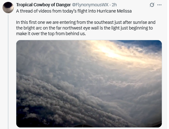
...
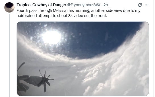
...
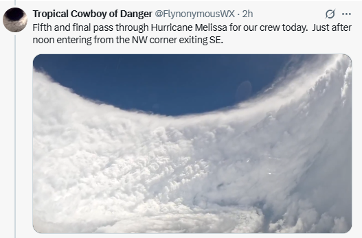
...
3:43 PM · Oct 27, 2025
---------------------------------------------
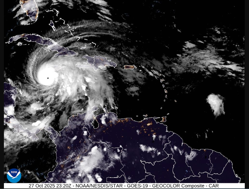
https://cdn.star.nesdis.noaa.gov/GOES19/ABI/SECTOR/car/GEOCOLOR/1000x1000.jpg
------------------------------------------------------------
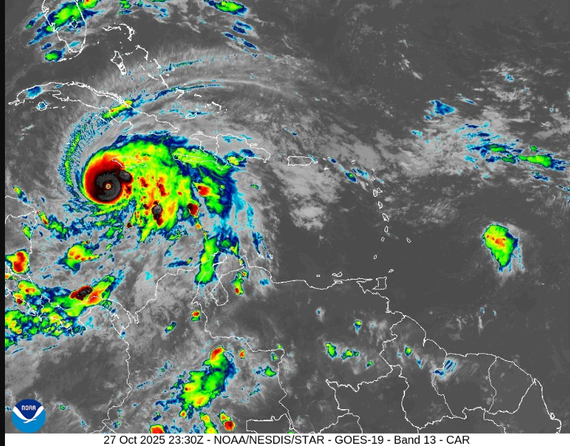
https://cdn.star.nesdis.noaa.gov/GOES19/ABI/SECTOR/car/13/1000x1000.jpg
@US_Stormwatch
·
1h
Colin McCarthy
@US_Stormwatch
·
1h
Hurricane Hunters are in the air right now, about to head straight into the heart of Category 5 Hurricane Melissa.
These brave men and women are literally flying into a 175+ mph monster to gather critical data that will help determine Melissa’s exact strength and path as it barrels toward Jamaica.
And here’s how dangerous this storm is: earlier today, one of the NOAA reconnaissance planes had to abort its mission and turn back because of “severe turbulence.”
These aircraft are built to withstand hurricanes and extreme turbulence, they almost never turn around. For one to retreat shows just how powerful Melissa truly is.
This next round of Hurricane Hunters reconnaissance data may reveal that Melissa ranks among the top 3 strongest Atlantic hurricanes ever recorded.
...
4:27 PM · Oct 27, 2025
------------------------------------------------------
ZCZC MIATCDAT3 ALL
TTAA00 KNHC DDHHMM
Hurricane Melissa Discussion Number 25
NWS National Hurricane Center Miami FL AL132025
1100 AM EDT Mon Oct 27 2025
Melissa has the classic strong hurricane appearance in satellite
imagery this morning, with a well-defined 10-nm wide eye embedded
in a central dense overcast with cloud tops colder than -80C. The
hurricane also has a large complex of outer banding over the
eastern semicircle and a circulation that covers most of the
Caribbean west of 70 degrees west longitude. Reports from NOAA and
Air Force Reserve Hurricane Hunter aircraft indicate the central
pressure has fallen to near 908 mb, with both aircraft releasing
dropsondes in the northeastern eyewall that support an initial
intensity of 145 kt. The NOAA aircraft left the storm early after
experiencing severe turbulence in the southwestern eyewall.
...
https://www.nhc.noaa.gov/archive/2025/al13/al132025.discus.025.shtml
-----------------------------------------------------------------------------------------------
Screenshots:
...
...
...
3:43 PM · Oct 27, 2025
---------------------------------------------
https://cdn.star.nesdis.noaa.gov/GOES19/ABI/SECTOR/car/GEOCOLOR/1000x1000.jpg
------------------------------------------------------------
https://cdn.star.nesdis.noaa.gov/GOES19/ABI/SECTOR/car/13/1000x1000.jpg
Pathfinder
Editor, Senior Moderator
...
...
Last edited3:21 AM · Oct 28, 2025
---------------------------------------------------------------------------------------------
Hurricane Melissa Public Advisory
[TABLE="border: 0, cellpadding: 0, cellspacing: 0"]
[TR]
[TD]Home Public Adv Fcst Adv Discussion Wind Probs Graphics Archive
Español: Aviso Publico Discusión
[/TD]
[/TR]
[/TABLE]
000
WTNT33 KNHC 280855
TCPAT3
BULLETIN
Hurricane Melissa Advisory Number 28
NWS National Hurricane Center Miami FL AL132025
500 AM EDT Tue Oct 28 2025
...CONDITIONS DETERIORATING ON JAMAICA AS EXTREMELY DANGEROUS
CATEGORY 5 MELISSA SLOWLY APPROACHES...
...CATASTROPHIC WINDS, FLASH FLOODING, AND STORM SURGE EXPECTED ON
THE ISLAND TODAY...
SUMMARY OF 500 AM EDT...0900 UTC...INFORMATION
----------------------------------------------
LOCATION...17.2N 78.3W
ABOUT 115 MI...180 KM WSW OF KINGSTON JAMAICA
ABOUT 290 MI...465 KM SW OF GUANTANAMO CUBA
MAXIMUM SUSTAINED WINDS...175 MPH...280 KM/H
PRESENT MOVEMENT...NNE OR 25 DEGREES AT 5 MPH...7 KM/H
MINIMUM CENTRAL PRESSURE...901 MB...26.61 INCHES
...
https://www.nhc.noaa.gov/text/refresh/MIATCPAT3+shtml/280855.shtml?
-----------------------------------------------------------------------------------
Hurricane Melissa Forecast Discussion
[TABLE="border: 0, cellpadding: 0, cellspacing: 0"]
[TR]
[TD]Home Public Adv Fcst Adv Discussion Wind Probs Graphics Archive
Español: Aviso Publico Discusión
[/TD]
[/TR]
[/TABLE]
000
WTNT43 KNHC 280857
TCDAT3
Hurricane Melissa Discussion Number 28
NWS National Hurricane Center Miami FL AL132025
500 AM EDT Tue Oct 28 2025
Melissa has a circular, 10-n-mi-wide eye surrounded by a symmetric
ring of very intense convection with cloud tops colder than -80 deg
C. Radar data from Jamaica suggests that a secondary outer eyewall
may have formed, which could signal that an eyewall replacement
cycle is underway. The last couple of overnight center fixes by the
Air Force Hurricane Hunters revealed 700-mb height falls within the
eye, and dropsonde data indicated the central pressure had fallen to
around 901 mb. A standard reduction of the peak 700-mb flight-level
winds from that mission (165 kt) supports an initial intensity of
150 kt. Conditions are deteriorating across Jamaica, where heavy
rainfall and tropical storm conditions have spread across the
island. NOAA and Air Force Hurricane Hunter aircraft are scheduled
to investigate the hurricane again this morning.
Melissa is moving slowly north-northeastward (025/4 kt). Over the
next several days, the hurricane is expected to accelerate to the
northeast within the flow ahead of an amplifying trough over the
southeastern U.S. This steering flow will bring the core of Melissa
across Jamaica today, over eastern Cuba early Wednesday, and across
the southeastern or central Bahamas later on Wednesday. Then, the
hurricane is forecast to pass near Bermuda Thursday night or early
Friday. Overall, the near-term NHC track forecast is very similar to
the previous one. At 72-120 h, the official forecast was adjusted to
the left of the previous prediction based on the latest multi-model
consensus aids and Google DeepMind ensemble guidance.
Near-term intensity fluctuations are possible this morning and will
likely be driven by internal dynamic processes like eyewall
replacement cycles. Regardless, Melissa will reach Jamaica as an
extremely dangerous major hurricane within the next 12 h. While land
interaction with Jamaica and eastern Cuba is expected to cause some
weakening, Melissa is still forecast to pass over portions of the
Bahamas as a strong hurricane on Wednesday. Increasing westerly
shear is likely to impact Melissa later this week while the
hurricane accelerates toward higher latitudes. As a result, the
hurricane is forecast to have a broader and asymmetric wind field
when it passes near Bermuda later this week. Some minor upward
adjustments were made to the NHC intensity forecast during the
middle portion of the period in agreement with the latest HCCA
and GDMI aids. Melissa is forecast to become a strong extratropical
cyclone over the North Atlantic by 96 h.
Key Messages:
1. Jamaica: Remain sheltered! Catastrophic flash flooding,
landslides, and destructive winds will continue through today,
causing widespread infrastructure damage, power and communication
outages, and isolated communities. Total structural failure is
possible near the path of Melissa’s center. Along the southern
coast, life-threatening storm surge and damaging waves are expected
through the day. Failure to act may result in serious injury or loss
of life.
2. Haiti and the Dominican Republic: Catastrophic flash flooding
and landslides are expected across southwestern Haiti and southern
portions of the Dominican Republic through midweek. In Haiti,
extensive damage and isolation of communities is likely. Tropical
storm conditions are expected later today and Wednesday.
3. Eastern Cuba: Heavy rainfall, flash flooding and landslides are
expected soon. Life-threatening storm surge and damaging winds are
likely to begin later today. Complete all preparations now.
4. Southeastern and Central Bahamas and the Turks and Caicos:
Hurricane conditions, life-threatening storm surge, and heavy
rainfall are expected across portions of the southeastern and
central Bahamas on Wednesday. Complete preparations by tonight and
follow local official guidance. Tropical storm conditions, heavy
rains, and significant storm surge are expected in the Turks and
Caicos Islands on Wednesday.
FORECAST POSITIONS AND MAX WINDS
INIT 28/0900Z 17.2N 78.3W 150 KT 175 MPH
12H 28/1800Z 18.2N 77.7W 145 KT 165 MPH...INLAND
24H 29/0600Z 19.9N 76.5W 120 KT 140 MPH...NEAR THE COAST
36H 29/1800Z 21.9N 75.1W 95 KT 110 MPH
48H 30/0600Z 24.6N 73.1W 90 KT 105 MPH
60H 30/1800Z 28.1N 70.0W 85 KT 100 MPH
72H 31/0600Z 32.4N 65.4W 80 KT 90 MPH
96H 01/0600Z 43.0N 52.0W 65 KT 75 MPH...POST-TROP/EXTRATROP
120H 02/0600Z 51.0N 35.0W 50 KT 60 MPH...POST-TROP/EXTRATROP
$$
Forecaster Reinhart
https://www.nhc.noaa.gov/text/refresh/MIATCDAT3+shtml/280857.shtml?
---------------------------------------------------------------------------------
https://cdn.star.nesdis.noaa.gov/GOES19/ABI/SECTOR/car/GEOCOLOR/1000x1000.jpg
--------------------------------------------------------------------------------
...
https://cdn.star.nesdis.noaa.gov/GOES19/ABI/SECTOR/car/13/1000x1000.jpg
Pathfinder
Editor, Senior Moderator
7:11 AM · Oct 28, 2025
-----------------------------------------------------------------------------------------------
(screenshot)
https://www.tropicaltidbits.com/sat/satlooper.php?region=13L&product=ir
Pathfinder
Editor, Senior Moderator
Pathfinder
Editor, Senior Moderator
Hurricane Melissa Public Advisory Update
[TABLE="border: 0, cellpadding: 0, cellspacing: 0"]
[TR]
[TD]Home UPDATE Public Adv Fcst Adv Discussion Wind Probs Graphics Archive
Español: Tropical Actualización Aviso Publico Discusión
[/TD]
[/TR]
[/TABLE]
000
WTNT63 KNHC 281259
TCUAT3
Hurricane Melissa Tropical Cyclone Update
NWS National Hurricane Center Miami FL AL132025
900 AM EDT Tue Oct 28 2025
...AIR FORCE RESERVE HURRICANE HUNTERS FIND MELISSA STRONGER AS THE
NORTHERN EYEWALL IS APPROACHING THE SOUTHERN COAST OF JAMAICA...
...900 AM EDT POSITION UPDATE...
The eye of Melissa is nearing the southern coast of Jamaica and is
expected to make landfall within the next few hours. This is an
extremely dangerous and a life-threatening situation. Take action
now to protect your life! Residents in the Jamaica should not leave
their shelter as winds will rapidly increase within the eyewall of
Melissa. Remain in place through the passage of these life-
threatening conditions.
An Air Force Reserve Hurricane Hunter aircraft has found that
Melissa is strengthening with maximum sustained winds of 180 mph
(290 km/h). Estimated minimum central pressure based on aircraft
data has fallen to 896 mb (26.47 inches).
Another position update will be provided at 1000 AM EDT (1400 UTC).
SUMMARY OF 900 AM EDT...1300 UTC...INFORMATION
----------------------------------------------
LOCATION...17.6N 78.1W
ABOUT 50 MI...80 KM SSE OF NEGRIL JAMAICA
ABOUT 260 MI...420 KM SW OF GUANTANAMO CUBA
MAXIMUM SUSTAINED WINDS...180 MPH...290 KM/H
PRESENT MOVEMENT...NNE OR 20 DEGREES AT 7 MPH...11 KM/H
MINIMUM CENTRAL PRESSURE...896 MB...26.47 INCHES
$$
Forecaster Kelly
https://www.nhc.noaa.gov/text/refresh/MIATCUAT3+shtml/281259.shtml?
[TABLE="border: 0, cellpadding: 0, cellspacing: 0"]
[TR]
[TD]Home UPDATE Public Adv Fcst Adv Discussion Wind Probs Graphics Archive
Español: Tropical Actualización Aviso Publico Discusión
[/TD]
[/TR]
[/TABLE]
000
WTNT63 KNHC 281259
TCUAT3
Hurricane Melissa Tropical Cyclone Update
NWS National Hurricane Center Miami FL AL132025
900 AM EDT Tue Oct 28 2025
...AIR FORCE RESERVE HURRICANE HUNTERS FIND MELISSA STRONGER AS THE
NORTHERN EYEWALL IS APPROACHING THE SOUTHERN COAST OF JAMAICA...
...900 AM EDT POSITION UPDATE...
The eye of Melissa is nearing the southern coast of Jamaica and is
expected to make landfall within the next few hours. This is an
extremely dangerous and a life-threatening situation. Take action
now to protect your life! Residents in the Jamaica should not leave
their shelter as winds will rapidly increase within the eyewall of
Melissa. Remain in place through the passage of these life-
threatening conditions.
An Air Force Reserve Hurricane Hunter aircraft has found that
Melissa is strengthening with maximum sustained winds of 180 mph
(290 km/h). Estimated minimum central pressure based on aircraft
data has fallen to 896 mb (26.47 inches).
Another position update will be provided at 1000 AM EDT (1400 UTC).
SUMMARY OF 900 AM EDT...1300 UTC...INFORMATION
----------------------------------------------
LOCATION...17.6N 78.1W
ABOUT 50 MI...80 KM SSE OF NEGRIL JAMAICA
ABOUT 260 MI...420 KM SW OF GUANTANAMO CUBA
MAXIMUM SUSTAINED WINDS...180 MPH...290 KM/H
PRESENT MOVEMENT...NNE OR 20 DEGREES AT 7 MPH...11 KM/H
MINIMUM CENTRAL PRESSURE...896 MB...26.47 INCHES
$$
Forecaster Kelly
https://www.nhc.noaa.gov/text/refresh/MIATCUAT3+shtml/281259.shtml?
Pathfinder
Editor, Senior Moderator
Jamaica, Cuba brace for Hurricane Melissa to make landfall today
...
The Associated Press · Posted: Oct 28, 2025 5:27 AM CDT | Last Updated: 43 minutes ago
...
Hurricane Melissa was set to pummel Jamaica on Tuesday as a catastrophic Category 5 storm, the strongest to lash the island since record-keeping began 174 years ago.
The storm was expected to make landfall early Tuesday and slice diagonally across the island, entering near St. Elizabeth Parish in the south and exiting around St. Ann Parish in the north, forecasters said. Shortly thereafter, Melissa is expected to hit Cuba.
Hours before the storm, the Jamaican government said it had done all it could to prepare as it warned of catastrophic damage.
"There is no infrastructure in the region that can withstand a Category 5," Prime Minister Andrew Holness said. "The question now is the speed of recovery. That's the challenge."
...
Colin Bogle, a Mercy Corps advisor based near Kingston, said most families are sheltering in place despite the government ordering evacuations in flood-prone communities.
...
https://www.cbc.ca/news/world/hurricane-melissa-tuesday-st-ann-jamaica-santiago-cuba-9.6956280
...
The Associated Press · Posted: Oct 28, 2025 5:27 AM CDT | Last Updated: 43 minutes ago
...
Hurricane Melissa was set to pummel Jamaica on Tuesday as a catastrophic Category 5 storm, the strongest to lash the island since record-keeping began 174 years ago.
The storm was expected to make landfall early Tuesday and slice diagonally across the island, entering near St. Elizabeth Parish in the south and exiting around St. Ann Parish in the north, forecasters said. Shortly thereafter, Melissa is expected to hit Cuba.
Hours before the storm, the Jamaican government said it had done all it could to prepare as it warned of catastrophic damage.
"There is no infrastructure in the region that can withstand a Category 5," Prime Minister Andrew Holness said. "The question now is the speed of recovery. That's the challenge."
...
Colin Bogle, a Mercy Corps advisor based near Kingston, said most families are sheltering in place despite the government ordering evacuations in flood-prone communities.
...
https://www.cbc.ca/news/world/hurricane-melissa-tuesday-st-ann-jamaica-santiago-cuba-9.6956280
Pathfinder
Editor, Senior Moderator
Hurricane Melissa Public Advisory Update
[TABLE="border: 0, cellpadding: 0, cellspacing: 0"]
[TR]
[TD]Home UPDATE Public Adv Fcst Adv Discussion Wind Probs Graphics Archive
Español: Tropical Actualización Aviso Publico Discusión
[/TD]
[/TR]
[/TABLE]
000
WTNT63 KNHC 281401
TCUAT3
Hurricane Melissa Tropical Cyclone Update
NWS National Hurricane Center Miami FL AL132025
1000 AM EDT Tue Oct 28 2025
...CATASTROPHIC WINDS MOVING ONSHORE SOUTHERN JAMAICA...
...LAST CHANCE TO PROTECT YOUR LIFE...
...1000 AM EDT POSITION UPDATE...
THIS IS AN EXTREMELY DANGEROUS AND LIFE-THREATENING SITUATION! TAKE
COVER NOW! Failure to adequately shelter may result in serious
injury, and loss of life. Residents in Jamaica that experience the
eye should not leave their shelter as winds will rapidly increase
within the backside of the eyewall of Melissa.
To protect yourself from wind, the best thing you can do is put as
many walls as possible between you and the outside. An interior room
without windows, ideally one where you can also avoid falling trees,
is the safest place you can be in a building. You can cover yourself
with a mattress and wear a helmet for added protection.
NOAA Hurricane Hunter Aircraft find that Melissa continues to
strengthen with maximum sustained winds of 185 mph (295 km/h).The
minimum central pressure has fallen to 892 mb (26.34 inches) based
on NOAA and Hurricane Hunter Air Force Reserve aircraft data.
The next update will be provided with the full advisory package at
1100 AM EDT (1500 UTC).
SUMMARY OF 1000 AM EDT...1400 UTC...INFORMATION
----------------------------------------------
LOCATION...17.7N 78.1W
ABOUT 45 MI...70 KM SSE OF NEGRIL JAMAICA
ABOUT 255 MI...410 KM SW OF GUANTANAMO CUBA
MAXIMUM SUSTAINED WINDS...185 MPH...295 KM/H
PRESENT MOVEMENT...NNE OR 20 DEGREES AT 7 MPH...11 KM/H
MINIMUM CENTRAL PRESSURE...892 MB...26.34 INCHES
$$
Forecaster Kelly
https://www.nhc.noaa.gov/text/refresh/MIATCUAT3+shtml/281401.shtml?
[TABLE="border: 0, cellpadding: 0, cellspacing: 0"]
[TR]
[TD]Home UPDATE Public Adv Fcst Adv Discussion Wind Probs Graphics Archive
Español: Tropical Actualización Aviso Publico Discusión
[/TD]
[/TR]
[/TABLE]
000
WTNT63 KNHC 281401
TCUAT3
Hurricane Melissa Tropical Cyclone Update
NWS National Hurricane Center Miami FL AL132025
1000 AM EDT Tue Oct 28 2025
...CATASTROPHIC WINDS MOVING ONSHORE SOUTHERN JAMAICA...
...LAST CHANCE TO PROTECT YOUR LIFE...
...1000 AM EDT POSITION UPDATE...
THIS IS AN EXTREMELY DANGEROUS AND LIFE-THREATENING SITUATION! TAKE
COVER NOW! Failure to adequately shelter may result in serious
injury, and loss of life. Residents in Jamaica that experience the
eye should not leave their shelter as winds will rapidly increase
within the backside of the eyewall of Melissa.
To protect yourself from wind, the best thing you can do is put as
many walls as possible between you and the outside. An interior room
without windows, ideally one where you can also avoid falling trees,
is the safest place you can be in a building. You can cover yourself
with a mattress and wear a helmet for added protection.
NOAA Hurricane Hunter Aircraft find that Melissa continues to
strengthen with maximum sustained winds of 185 mph (295 km/h).The
minimum central pressure has fallen to 892 mb (26.34 inches) based
on NOAA and Hurricane Hunter Air Force Reserve aircraft data.
The next update will be provided with the full advisory package at
1100 AM EDT (1500 UTC).
SUMMARY OF 1000 AM EDT...1400 UTC...INFORMATION
----------------------------------------------
LOCATION...17.7N 78.1W
ABOUT 45 MI...70 KM SSE OF NEGRIL JAMAICA
ABOUT 255 MI...410 KM SW OF GUANTANAMO CUBA
MAXIMUM SUSTAINED WINDS...185 MPH...295 KM/H
PRESENT MOVEMENT...NNE OR 20 DEGREES AT 7 MPH...11 KM/H
MINIMUM CENTRAL PRESSURE...892 MB...26.34 INCHES
$$
Forecaster Kelly
https://www.nhc.noaa.gov/text/refresh/MIATCUAT3+shtml/281401.shtml?