
Mary Wilson
Well-known member
October 7, 2022
Water levels on the Mississippi River normally decline in the fall and winter, but not by nearly as much as they did in October 2022. Lack of rain in the Ohio River Valley and Upper Mississippi River Valley in recent weeks caused river water to drop to levels not seen in more than a decade along key parts of the river. The low water levels are slowing barge traffic and raising concerns that saltwater intrusions in the Lower Mississippi could affect water supplies.
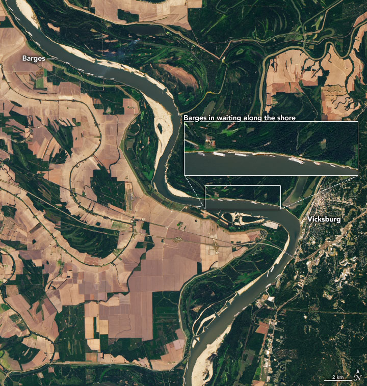
The Operational Land Imager (OLI-2) on Landsat 9 captured this natural-color image of the parched river on October 7, 2022. The image shows backed-up barges north of Vicksburg, Mississippi. At times, well over 100 towboats and barges waited due to a temporary river closure caused by barge groundings and dredging work, according to news reports. The towboats and barges are strung together into groups that vary in size but can easily be 1,000 feet (300 meters) long and 100 feet (30 meters) wide.
The map above shows how wet the soil was on the same day the Landsat 8 image was acquired. Using data from the Crop Condition and Soil Moisture Analytics (Crop-CASMA) product, the map shows soil moisture anomalies on October 7, 2022, or how the water content in the top meter (3 feet) of soil compared to normal conditions for the time of year. Brown areas were drier; blue areas were wetter. ...
https://earthobservatory.nasa.gov/images/150504/drought-and-barge-backups-on-the-mississippi
Water levels on the Mississippi River normally decline in the fall and winter, but not by nearly as much as they did in October 2022. Lack of rain in the Ohio River Valley and Upper Mississippi River Valley in recent weeks caused river water to drop to levels not seen in more than a decade along key parts of the river. The low water levels are slowing barge traffic and raising concerns that saltwater intrusions in the Lower Mississippi could affect water supplies.
The Operational Land Imager (OLI-2) on Landsat 9 captured this natural-color image of the parched river on October 7, 2022. The image shows backed-up barges north of Vicksburg, Mississippi. At times, well over 100 towboats and barges waited due to a temporary river closure caused by barge groundings and dredging work, according to news reports. The towboats and barges are strung together into groups that vary in size but can easily be 1,000 feet (300 meters) long and 100 feet (30 meters) wide.
The map above shows how wet the soil was on the same day the Landsat 8 image was acquired. Using data from the Crop Condition and Soil Moisture Analytics (Crop-CASMA) product, the map shows soil moisture anomalies on October 7, 2022, or how the water content in the top meter (3 feet) of soil compared to normal conditions for the time of year. Brown areas were drier; blue areas were wetter. ...
https://earthobservatory.nasa.gov/images/150504/drought-and-barge-backups-on-the-mississippi