• FluTrackers.com Inc. does not provide medical advice. Information on this web site is collected from various internet resources, and the FluTrackers board of directors makes no warranty to the safety, efficacy, correctness or completeness of the information posted on this site by any author or poster. The information collated here is for instructional and/or discussion purposes only and is NOT intended to diagnose or treat any disease, illness, or other medical condition. Every individual reader or poster should seek advice from their personal physician/healthcare practitioner before considering or using any interventions that are discussed on this website. By continuing to access this website you agree to consult your personal physican before using any interventions posted on this website, and you agree to hold harmless FluTrackers.com Inc., the board of directors, the members, and all authors and posters for any effects from use of any medication, supplement, vitamin or other substance, device, intervention, etc. mentioned in posts on this website, or other internet venues referenced in posts on this website.
  • We are not asking for any donations. Do not donate to any entity who says they are raising funds for us.

China raises emergency level as heavy rain triggers floods - watching Three Gorges Dam - July 7, 2020

2020-08-01 10:14:44Beijing News


Severe convective weather warning is issued: It is expected that there will be thunderstorms or hail in Beijing, Tianjin, Hebei and other places


Beijing News Express Central Meteorological Observatory issued a blue warning of severe convective weather at 10:00 on August 1:


It is expected that from 14:00 on August 1st to 14:00 on August 2, the eastern and central southern regions of Inner Mongolia, the central and western parts of Heilongjiang and the northeast, the northeast of Shaanxi, the northwest and east of Shanxi, the central and western parts of Hebei, Beijing, the north of Tianjin, and the central Shandong There will be 8-10 thunderstorms or hail in local areas such as the western and northeastern, northeastern Henan, southeastern Guizhou, central and eastern Fujian, northwest and southeastern Guangxi, and southern central and western parts of Guangdong. Southern region, northern and western Heilongjiang, western Jilin, northeastern Liaoning, southern and northeastern Shaanxi, northwest and eastern Shanxi, most of Hebei, Tianjin, most of Shandong, central and northern Henan, southern and northeastern Anhui, central and eastern Jiangsu, Some areas in central and southern Sichuan, northwestern Hubei, eastern Guizhou, southern and central and western Hunan, southwestern Jiangxi, central and eastern Fujian, western and southern Yunnan, southern and central Guangxi, southern Guangdong, and parts of Hainan will have short periods. In heavy rainfall weather, the hourly rain is 30-50 mm, and the local area can reach more than 70 mm.


It is estimated that the main impact period of strong convective weather in North China, Huanghuai and other places is from today's afternoon to night.


http://www.bjnews.com.cn/news/2020/08/01/754359.html
 
More than 3,000 soldiers and civilians continued to fight for five days and five nights and successfully blocked the leaking culvert gate of Daijia Lake, Yingshang County, Anhui


13:14, August 1, 2020 Source: CCTV News Client


  Today (31st) at 5 o’clock in the afternoon, as the excavator poured earth and stone into the waters of the damaged gate, it closed with the sandbags thrown by the PLA officers and soldiers on the water. Yingshang Daijia Lake leaked culvert gate. After five days and five nights of continuous rescue work, it was finally realized Completely block, and completely eliminate the danger of water leakage.
  At 10:00 on July 26, the Daijiahu culvert gate in Yingshang County, Fuyang, Anhui Province was damaged. A 10-meter-diameter whirlpool formed behind the embankment. The Huaihe River in the flood storage area directly flooded the surrounding 7 administrative villages. More than 8,000 local villagers were in emergency Evacuate.
  The local organization organized more than 100 large machinery and more than 1,000 militia cadres and masses, together with more than 2,000 troops and soldiers who came to the rescue, to fight around the clock. As the road leading to the culvert gate was too narrow, it was not convenient for mechanical and manual approach and blockage operations. The water conservancy experts decided in consultation to adopt the method of throwing earth and rock at the gate and constructing a cofferdam at the water outlet to block it, which started a military-civilian collaboration day and night. An emergency battle.
  At 3 p.m. on July 30, after 95 excavators and 58 bulldozers were working day and night, the 600-meter-long water-retaining cofferdam built on the back surface of the leaking culvert gate was closed, and the Huai River stopped pouring into the surrounding villages. Get preliminary control.

  Since the newly constructed cofferdam cannot withstand the long-term high water level immersion, the leaking culvert gate must be completely blocked. The front-line headquarters decided to urgently build a crescent embankment on the waterfront, fill the water area where the leaking culvert gate is located with earth and stone, and thoroughly control the danger of water leakage.
  With the help of the power pontoon bridge erected by the pontoon bridge force, more than 2,000 PLA ​​troops threw sandbags at the damaged culvert gate through the water, blocking the 12-meter-deep culvert gate inlet. At the same time, large-scale machinery on the shore continued to push earth and stone into the water, eventually forming a closed crescent embankment around the leaking culvert gate.
  As leaking culverts and gates are completely blocked, the water level in the backwater retaining cofferdam has dropped rapidly after being drained.
  After more than 3,000 soldiers and civilians continued to fight for five days and five nights, the danger of leakage of the Daijiahu culvert gate was thoroughly controlled. At present, large-scale machinery is stepping up efforts to reinforce the crescent levee facing the water to ensure that leaking culvert gates are foolproof.


http://www.chinanews.com/sh/2020/08-01/9253740.shtml
 
The Three Gorges Dam opens a deep hole for flood discharge

On July 31, the Three Gorges Project opened a deep hole for flood discharge.
According to the real-time water conditions of the Yangtze River Hydrological Network, the water level of the Three Gorges Reservoir was 161.08 meters at 22:00 on July 31, and the outflow flow was 38,700 cubic meters per second.
The Three Gorges Reservoir maintains the discharge flow to free up the storage capacity to intercept the next flood.

http://www.chinanews.com/tp/hd2011/2...1/950369.shtml
 
The Ministry of Water Resources predicts possible numbered floods in the middle reaches of the Yellow River


August 04, 2020 22:40 Source: Xinhuanet


  Xinhua News Agency, Beijing, August 4 (Reporter Hu Lu) According to weather forecasts and flood development, the Ministry of Water Resources predicted on the 4th that numbered floods may occur in the middle reaches of the Yellow River. The Ministry of Water Resources requires that risk awareness and bottom-line thinking be strengthened, and various defenses should be carried out in a targeted and comprehensive manner based on actual conditions.
  Weather forecasts show that in the next three days, under the combined influence of cold and warm air, there will be moderate to heavy rains in the eastern northwest, southern central northern China, northern eastern Huanghuai, northern central northeast and central northern Sichuan. In addition, typhoon Hagupit and tropical clouds in the South China Sea may affect parts of the central coast of East China, the coast of South China, and southeastern Yunnan.
  According to the Ministry of Water Resources, affected by this, the average water level of Lake Taihu will rise slightly. Numbered floods may occur in the main stream of the middle reaches of the Yellow River. Some tributaries of Shanxi-Shaanxi, Jinghe, Beiluo, Fen, Qin and Dawen Rivers in the lower reaches, Daqing River, Ziya River, Zhangwei River in the southern part of Haihe River, and Guangdong The coastal areas of Guiqiong and Nenjiang, a tributary of the Songhua River, may experience significant flooding. Some small and medium-sized rivers in the rainstorm area may be over-alarm.
  Minister of Water Resources E Jingping said at the meeting on the 4th that the water levels in the middle and lower reaches of the Yangtze River, the middle reaches of the Huaihe River, and the Taihu Lake are still high, and there are still heavy rainfall processes in the Yellow and Haihe River basins. The typhoon will also affect Shanghai, Zhejiang, Jiangsu and other provinces and cities. It is necessary to carry out various defenses in a targeted and comprehensive manner in accordance with the actual situation. It is also necessary to always pay attention to the development of drought, actively take measures, and always adhere to both flood prevention and drought resistance.

  One is to closely monitor the process of heavy rainfall in the Haihe River Basin. It is necessary to deploy targeted preparations for heavy rainfall in advance, scientifically dispatch reservoirs, give full play to the role of flood blocking and peak reduction, and timely carry out river clearing to ensure smooth flood passage. It is also necessary to make preparations for the use of flood storage and detention areas in advance to ensure timely and effective flood distribution.
  The second is to implement flood prevention measures in the middle reaches of the Yellow River. It is necessary to scientifically dispatch the backbone reservoirs such as Xiaolangdi and Wanjiazhai to block floods and reduce peaks, conscientiously implement various measures such as small reservoirs and silt dams to prevent floods and mountain flood disasters, and strengthen supervision and unannounced visits and inspections to ensure flood control safety .
  The third is to strengthen drought monitoring, optimize water conservancy project scheduling and water allocation, scientifically formulate water use plans and watershed and regional water emergency scheduling plans to ensure drinking water safety in urban and rural areas and provide strong support for food security.
  The fourth is to strengthen the inspection and defense of dikes. The Yangtze River, Huaihe River, and Taihu Lake basins continue to have high water levels, and the dikes have been immersed for a long time. We must always tighten the string of flood prevention and flood resistance, especially in the areas affected by the superimposed typhoon "Haguebee". We must fully cover the dikes to ensure early detection of dangers. , Early treatment, early elimination.


http://www.chinanews.com/gn/2020/08-04/9256481.shtml
 
Gansu issued a yellow flood warning: over-alarm floods will occur in the Taohe River in Luqu
August 05, 2020 08:22 Interface News

  Original title: Lintao, Gansu issued a yellow flood warning: Super-alarm floods will occur in the Tao River in Luqu County

  The Lintao Hydrology and Water Resources Survey Bureau of Gansu Province will continue to issue a flood yellow warning at 8:22 on August 5, 2020: Affected by the upstream rainfall and continuous inflow of water, the Tao River in Luqu County, Gannan Tibetan Autonomous Prefecture will continue to have high water levels. It is expected that the next 24 hours There will be a super-alarm flood. The downstream units along the river and the public are requested to strengthen prevention and avoid danger in time.

https://news.sina.com.cn/c/2020-08-0...x9262601.shtml
 
Anhui Hefei issued a red flood warning: 5 sections of the Chaohu Lake Basin are still above the guaranteed water level
August 05, 2020 08:18 Interface News
1

  Original title: Hefei, Anhui issued a red flood warning: 5 sections of the Chaohu Lake Basin are still above the guaranteed water level

  The Hefei Hydrology and Water Resources Bureau of Anhui Province issued a red flood warning at 8:18 on August 5, 2020: At present, Chaohu Lake has fallen below the historical flood level, showing a high level and slowly receding state. The lower reaches of the Yuxi River, Hangbu River, Nanfei River, Zhagao River, and Baishitian River in the Chaohu Basin are still above the guaranteed water level; the lower reaches of Fengle River are still falling above the warning water level; the Xihe and Zhaohe rivers are above the guaranteed water level. The water level fluctuates. Please take precautions for coastal units and residents.

https://news.sina.com.cn/c/2020-08-0...n6885026.shtml
 
2020-08-09 10:18:36Beijing News


Severe convective weather blue warning issued: Beijing and other provinces will have thunderstorms and gales


Beijing News Express According to the website of the Central Meteorological Observatory, the Central Meteorological Observatory issued a blue warning for severe convective weather at 10:00 on August 9th:


It is estimated that from 14:00 on August 9 to 14:00 on August 10, southeast and central Inner Mongolia, southwest and central Heilongjiang, central and western Jilin, northern Liaoning, central and eastern Gansu, northern Shaanxi, central and northern Shanxi, central and northern Hebei, and Beijing There will be 8-10 thunderstorms or hail in parts of the west and southeast, northern and western Tianjin, eastern Hubei and other places; eastern Inner Mongolia, southwest and central Heilongjiang, western Jilin, northern and western Liaoning, central and southern Gansu, Northern Shaanxi, central Shanxi, central and northeastern Hebei, Beijing, northern Tianjin, central and southern Anhui, central and southern Jiangsu, northern Shanghai, eastern and southern Hubei, central and western Hunan, northwest and southern Jiangxi, southern Zhejiang, Some areas in the northern Sichuan Basin, central and southern Guizhou, central and southern Yunnan, and northwestern Guangxi will have short-term heavy rainfall. The hourly rainfall is 30-50 mm, and the local area can reach more than 70 mm.


It is estimated that the main influence period of strong convection is from the evening to the first half of the night.


http://www.bjnews.com.cn/news/2020/08/09/756842.html
 
2020-08-18 10:08:44


Preliminary statistics on flood disasters in Longnan, Gansu, over 280,000 people were affected


According to the news from the official Weibo of the Foreign Propaganda Office of Longnan City, Gansu Province on August 18, according to the news from the Beijing News, according to the Longnan Emergency Management Bureau, since August 11, two heavy rainfall processes have occurred in Longnan City. Floods occurred in Wudu District, Kang County, Wen County, Cheng County, Li County, Hui County, and Liangdang County.


According to preliminary statistics, the disaster caused 286,796 people in 80,288 households in 1810 villages in 153 towns in 8 counties and districts. As of 19:00 on the 17th, the direct economic loss was 151,274,836 million yuan, of which agricultural economic losses were 23,351,526 million yuan, industrial and mining enterprises lost 1.12 million yuan, and basic The loss of facilities was 1151.9681 million yuan, the loss of public welfare facilities was 11.394 million yuan, and the loss of family property was 115.0494 million yuan. The city’s emergency relocation of 1,023 households with 38,661 people, 426 houses with 1,273 houses collapsed, 1,615 houses with 5,076 houses seriously damaged, and 2,880 houses with 9,019 houses generally damaged.

http://www.bjnews.com.cn/news/2020/08/18/759798.html
 
2020-08-18 09:11:25Beijing News Editor: Bi Wenrong


The first level I flood control emergency response was launched in history. Why will Sichuan become the national precipitation center in August?


At 5 o'clock on August 18th, Sichuan initiated Level I flood control emergency response. This is the first time Sichuan has initiated Level I flood control emergency response. Since August 14th, Sichuan has encountered a new round of heavy rainfall, with a rainfall of nearly 800 mm in 60 hours. On the 16th, the Sichuan Meteorological Observatory announced that "Sichuan has become the precipitation center of the country in August." Why is this rainfall so strong? According to expert analysis, heavy rainfall is caused by comprehensive factors such as climate and topography.


http://www.bjnews.com.cn/news/2020/08/18/759798.html
 
2020-08-18 10:13:26Beijing News reporter: Tian Meng


The fifth flood of 2020 on the Yellow River


According to CCTV news, on August 18, CCTV reporters from the Central Station learned from the Yellow River Conservancy Commission that due to recent rainfall, the flow of major hydrological stations in the Weihe River continued to rise, coupled with the water coming from the north main stream of the Yellow River, the Yellow River Tongguan Hydrological Station August 18 At 5:06, there is a flow of 5,050 cubic meters per second, which is the fifth flood of the Yellow River in 2020.


According to the weather forecast and the water conditions in the middle and lower reaches of the Yellow River, the Sanmenxia Reservoir was opened for use at 20 o'clock on August 17, and the Xiaolangdi Reservoir continued to intercept flood and sediment discharge at 1,800 cubic meters per second, creating conditions for Dongping Lake to discharge water.


At the same time, the Yellow Committee issued the "Notice on the Fifth Flood of the Yellow River in 2020" to the Water Resources Department of Shanxi, Shaanxi, Henan, and Shandong. Relevant provinces and units are invited to attach great importance to the development of the Xiaobei main stream of the Yellow River, Sanmenxia reservoir area, and Dongping Lake flood defense and related downstream flood prevention work.


http://www.bjnews.com.cn/news/2020/08/18/759799.html
 
On the way to Three Gorges Dam.


2020-08-18 14:06:14Beijing News reporter: Zhu Bisheng Editor: Shi Jihong


Directly hitting the flood crossing in Leshan, Sichuan: The river flooded to the toe of the Leshan Giant Buddha for the first time since 1949


On August 18, affected by the upstream water in Leshan, Sichuan and the local rainstorm, the water level at the confluence of the three rivers skyrocketed, and the foot platform of the Leshan Giant Buddha was submerged. The Big Buddha Scenic Spot confirmed that this is the first time since the founding of New China that the Leshan Giant Buddha has been flooded to its toes, and all 180 tourists staying in the scenic spot have been moved to a safe place. The Leshan Giant Buddha Scenic Area is located at the confluence of the Minjiang River, Qingyi River and Dadu River. On the 18th, three rivers flooded the border. Under the overlapping influence, the flood control situation in Leshan was severe, and the local area launched a Class I flood control emergency response.

http://www.bjnews.com.cn/wevideo/2020/08/18/759880.html
 
https://forum.effectivealtruism.org...l-three-gorges-dam-collapse-and-kill-millions


https://forum.effectivealtruism.org/...-kill-millions


There is serious concern that China's Three Gorges Dam may fail due to heavy flooding.
And that if it fails, it would kill millions of people, perhaps 100 million


biggest non-pandemic disaster in history a


already evacuated 38 million


can hold back waters to a level of 175 meters above sea level

height at the dam was 158.85 meters, down from 164 meters on Tuesday.
 
2020-08-20 10:22:27Beijing News reporter: Huang Zhecheng Editor: Fan Yijing


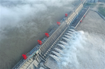
Flood peak crossing the Three Gorges Reservoir opens 10 flood discharge holes


Beijing News (Reporter Huang Zhecheng) The reporter learned from the Ministry of Water Resources yesterday that due to the large river basin floods in the Yangtze River, the largest flood since 1981 occurred in the upper reaches of the Yangtze River. . At 9 o'clock yesterday, the Ministry of Water Resources upgraded the level III emergency response of flood and drought disaster prevention to level II.
  
According to the CCTV news client, on the morning of the 19th, the peak of the No. 5 flood of the Yangtze River began to enter the Three Gorges Reservoir. The Three Gorges Reservoir opened 10 flood discharges, and the discharge flow reached 48,000 cubic meters per second, which is also the largest discharge since the construction of the Three Gorges Reservoir.
  
4960459648089006400.jpg


Yesterday, the Three Gorges Reservoir opened 10 flood discharge holes to face the largest flood peak since the construction of the reservoir. Picture/People's Vision


The Three Gorges Reservoir is expected to usher in the biggest flood today
  
From August 11th to 17th, two successive heavy rainfall processes occurred in the Jiamin River Basin in the upper reaches of the Yangtze River. During the process, the rainfall was concentrated, intense, and extreme. The cumulative rainfall was greater than 250 mm and covered an area of ​​67,000 square kilometers, and the area was greater than 100 mm. Covering an area of ​​227,000 square kilometers, the cumulative rainfall of Beichuan Station reached 946 mm. The rainfall in the process, the coverage of the rain area, and the maximum rainfall at a single station all exceeded the rainfall during the same period of the 1981 upstream catastrophic flood.
  
It is estimated that on August 20, the Three Gorges Reservoir on the Yangtze River will have a peak flow of about 76,000 cubic meters per second, which is the largest flood since 1981 and the largest flood into the reservoir since the construction of the Three Gorges Reservoir. The estimated flow of the Three Gorges Reservoir exceeds 50,000 cubic meters per second. The duration will be up to 5 days.
  
The Chongqing section of the Yangtze River floods many roads in the main city
  
According to the news of CCTV news client, "Yangtze River 2020 No. 5 Flood" passed through the main city of Chongqing on the 19th, and the water level at several stations on the Chongqing section of the Yangtze River exceeded the guaranteed. On the 18th, Chongqing also launched its first flood control emergency response in record. According to data from the water conservancy department, this flood peak is the largest flood peak passing through the main city of Chongqing since 1981.
  
As of 10 o'clock on the 19th, Nanbin Road in Chongqing City has become a vast expanse and has been closed. The 3-meter-high Yanyu Road sign has been completely submerged in water, and shops and buildings have flooded.
  
From the evening of the 18th to the morning of the 19th, the water level at Chaotianmen Station rose by more than 3 meters, exceeding the guaranteed water level by 5.69 meters, and is still rising.
  
Many departments in Chongqing City quickly adopted a number of response measures, and the local power department removed the substation in advance. On the evening of the 18th, local people were evacuated ahead of time. At present, firefighters are still using assault boats to transport the trapped people in time.
  
The Ministry of Water Resources requires the optimization of the storage and dispatching of the upper Yangtze River reservoir group
  
On the 18th, Ye Jianchun, deputy minister of the Ministry of Water Resources, hosted two conferences and chambers of commerce, requesting to further optimize the upstream reservoir group blocking and scheduling. The Yangtze River Water Conservancy Commission of the Ministry of Water Resources has further explored the flood retention potential of the cascade reservoirs in the Jinping I and Ertan of the Yalong River, Xiluodu, Xiangjiaba, Wudongde of the Jinsha River, Pubugou of the Dadu River, and Tingzikou of the Jialing River, and optimized the retention time sequence. Accurately intercepting floods and cutting peaks, the upstream reservoir group initially arranged to intercept 3.5 billion cubic meters.
  
In addition, the consultation required timely adjustment of the discharge flow of the Three Gorges, and overall reduction of the flood control pressure in the reservoir area and downstream.


http://www.bjnews.com.cn/news/2020/08/20/760591.html
 
from bing summaries :
peak expected Thursady (today) with 75000 tons per sec
The Ministry of Water Resources of China said on Wednesday that it expects
the peak flow of the Three Gorges Reservoir to reach 76,000 cubic meters per second on Thursday,
At present, the Three Gorges Project has opened 11 flood discharge holes, with a discharge
flow of 49,200 cubic meters per second
-----------------------------------------------------------------------------------------------
https://www.guancha.cn/politics/2020....shtml?s=zwytt
Chinese expert, copyright
 
I do not think the the dam is in any real danger of catastrophic failure. I did some calculations at the time of the Chengdu earthquake (which exceeded the Richter scale design spec of the dam) to see what the total energy release would be and what the downstream effects would be. They were not dissimilar from the scenario you paint.
The problem is the total volume of water in the Yangtze catchment basin and how to get it out to sea while minimising the impact of the floods. The dam can temporary hold some of the water for a while but within limits. There unenviable choices are 1] floods in the up stream section, 2] floods in the down stream section or 3] strain on the dam. The dam can protect itself but only at the expense of the down stream reaches.
 
Source: https://www.ft.com/content/58ed7f38-507d-4727-887a-e50afa934b92

China’s Three Gorges dam hits highest level amid torrential rain
Upper reaches of Yangtze river face fifth round of flooding this summer
The flow rate of water into the massive Three Gorges dam was at 75,000 cubic metres a second on Thursday, topping the previous 2012 record of 71,200 ? Xinhua/PA
Christian Shepherd and Emma Zhou 5 hours ago

Water levels at China’s Three Gorges dam are at their highest ever as months of torrential rain overwhelm the country’s flood defences and threaten its economic recovery.

In the last few months southern China has suffered its heaviest rainfall since 1998 when floods killed more than 3,000. The upper reaches of the Yangtze river are facing their fifth round of flooding this summer, in what Chinese state media has dubbed a “once-in-a-century” event.

The flow rate of water into the massive Three Gorges dam was at 75,000 cubic metres a second on Thursday, topping the previous 2012 record of 71,200, according to Chinese state media.

State broadcaster CCTV live-streamed images of muddy water geysering through the opened sluices of the dam, which were discharging at a rate of 49,200 cu m/sec, also the highest in history...
 
Back
Top Bottom