
SonicHappyHourAddict
Well-known member
Re: Alaska earthquake 5.7 - near Anchorage
here's the link to recent earthquakes. A you can see in the graph, most stronger quakes in the past 30 days surrounds the edges of the pacific plate.

http://neic.usgs.gov/neis/qed/
Japan had quakes following Alaska.
Update time = Tue Jun 23 9:16:51 UTC 2009
MAG UTC DATE-TIME
y/m/d h:m:s LAT
deg LON
deg DEPTH
km Region
MAP 5.7 2009/06/23 07:37:19 38.894 142.398 47.3 NEAR THE EAST COAST OF HONSHU, JAPAN
MAP 5.0 2009/06/23 07:24:13 39.210 143.426 25.0 OFF THE EAST COAST OF HONSHU, JAPAN
MAP 5.0 2009/06/22 23:10:05 12.168 94.994 25.7 ANDAMAN ISLANDS, INDIA REGION
MAP 5.3 2009/06/22 22:24:10 -23.900 179.947 511.9 SOUTH OF THE FIJI ISLANDS
MAP 5.2 2009/06/22 22:05:15 -3.491 146.477 38.0 BISMARCK SEA
MAP 5.5 2009/06/22 21:05:34 51.471 -178.306 24.4 ANDREANOF ISLANDS, ALEUTIAN IS., ALASKA
MAP 5.5 2009/06/22 19:55:24 51.276 -178.243 35.0 ANDREANOF ISLANDS, ALEUTIAN IS., ALASKA
MAP 5.4 2009/06/22 19:28:05 61.922 -150.654 52.7 SOUTHERN ALASKA
MAP 5.1 2009/06/22 19:05:17 76.195 6.894 10.0 SVALBARD REGION
MAP 5.4 2009/06/22 18:15:40 76.237 6.812 10.0 SVALBARD REGION
MAP 5.1 2009/06/21 12:27:07 76.385 7.079 10.0 SVALBARD REGION
MAP 5.6 2009/06/20 09:21:25 -4.974 103.040 54.6 SOUTHERN SUMATRA, INDONESIA
MAP 5.1 2009/06/20 02:52:58 39.100 143.173 25.8 OFF THE EAST COAST OF HONSHU, JAPAN
MAP 5.5 2009/06/19 15:06:25 14.057 145.139 113.5 ROTA REGION, NORTHERN MARIANA ISLANDS
MAP 5.9 2009/06/19 14:05:01 35.385 28.391 40.4 EASTERN MEDITERRANEAN SEA
MAP 5.3 2009/06/19 10:36:24 -20.985 -68.462 109.8 ANTOFAGASTA, CHILE
MAP 5.0 2009/06/18 06:21:06 31.288 141.767 39.4 IZU ISLANDS, JAPAN REGION
MAP 5.6 2009/06/17 07:08:19 51.650 -175.223 35.0 ANDREANOF ISLANDS, ALEUTIAN IS., ALASKA
MAP 6.2 2009/06/16 20:05:57 -54.387 5.843 10.0 BOUVET ISLAND REGION
MAP 5.0 2009/06/16 17:52:42 -4.038 126.370 35.2 BANDA SEA
http://earthquake.usgs.gov/eqcenter/recenteqsww/Quakes/quakes_big.php
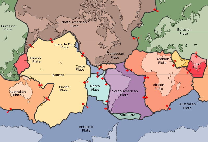
To the north the easterly side is a divergent boundary with the Explorer Plate, the Juan de Fuca Plate and the Gorda Plate forming respectively the Explorer Ridge, the Juan de Fuca Ridge and the Gorda Ridge. In the middle the easterly side is a transform boundary with the North American Plate along the San Andreas Fault and a boundary with the Cocos Plate. To the south the easterly side is a divergent boundary with the Nazca Plate forming the East Pacific Rise.
The southerly side is a divergent boundary with the Antarctic Plate forming the Pacific-Antarctic Ridge.
The westerly side is a convergent boundary subducting under the Eurasian Plate to the north and the Philippine Plate in the middle forming the Mariana Trench. In the south, the Pacific Plate has a complex but generally convergent boundary with the Indo-Australian Plate, subducting under it north of New Zealand forming the Tonga Trench and the Kermadec Trench. The Alpine Fault marks a transform boundary between the two plates, and further south the Indo-Australian Plate subducts under the Pacific Plate forming the Puysegur Trench. The part of Zealandia to the east of this boundary is the plate's largest block of continental crust.
The northerly side is a convergent boundary subducting under the North American Plate forming the Aleutian Trench and the corresponding Aleutian Islands.
The Pacific Plate contains an interior hot spot forming the Hawaiian Islands.
It is believed that the Pacific Plate is moving in unison with the minor, Bird's Head Plate.
http://en.wikipedia.org/wiki/Pacific_Plate
Without reviewing the local tectonics (and assuming this is not related to magma movement) the depth seems to indicate an earthquake occcuring within the subducting slab of the Pacific Plate.
here's the link to recent earthquakes. A you can see in the graph, most stronger quakes in the past 30 days surrounds the edges of the pacific plate.
http://neic.usgs.gov/neis/qed/
Japan had quakes following Alaska.
Update time = Tue Jun 23 9:16:51 UTC 2009
MAG UTC DATE-TIME
y/m/d h:m:s LAT
deg LON
deg DEPTH
km Region
MAP 5.7 2009/06/23 07:37:19 38.894 142.398 47.3 NEAR THE EAST COAST OF HONSHU, JAPAN
MAP 5.0 2009/06/23 07:24:13 39.210 143.426 25.0 OFF THE EAST COAST OF HONSHU, JAPAN
MAP 5.0 2009/06/22 23:10:05 12.168 94.994 25.7 ANDAMAN ISLANDS, INDIA REGION
MAP 5.3 2009/06/22 22:24:10 -23.900 179.947 511.9 SOUTH OF THE FIJI ISLANDS
MAP 5.2 2009/06/22 22:05:15 -3.491 146.477 38.0 BISMARCK SEA
MAP 5.5 2009/06/22 21:05:34 51.471 -178.306 24.4 ANDREANOF ISLANDS, ALEUTIAN IS., ALASKA
MAP 5.5 2009/06/22 19:55:24 51.276 -178.243 35.0 ANDREANOF ISLANDS, ALEUTIAN IS., ALASKA
MAP 5.4 2009/06/22 19:28:05 61.922 -150.654 52.7 SOUTHERN ALASKA
MAP 5.1 2009/06/22 19:05:17 76.195 6.894 10.0 SVALBARD REGION
MAP 5.4 2009/06/22 18:15:40 76.237 6.812 10.0 SVALBARD REGION
MAP 5.1 2009/06/21 12:27:07 76.385 7.079 10.0 SVALBARD REGION
MAP 5.6 2009/06/20 09:21:25 -4.974 103.040 54.6 SOUTHERN SUMATRA, INDONESIA
MAP 5.1 2009/06/20 02:52:58 39.100 143.173 25.8 OFF THE EAST COAST OF HONSHU, JAPAN
MAP 5.5 2009/06/19 15:06:25 14.057 145.139 113.5 ROTA REGION, NORTHERN MARIANA ISLANDS
MAP 5.9 2009/06/19 14:05:01 35.385 28.391 40.4 EASTERN MEDITERRANEAN SEA
MAP 5.3 2009/06/19 10:36:24 -20.985 -68.462 109.8 ANTOFAGASTA, CHILE
MAP 5.0 2009/06/18 06:21:06 31.288 141.767 39.4 IZU ISLANDS, JAPAN REGION
MAP 5.6 2009/06/17 07:08:19 51.650 -175.223 35.0 ANDREANOF ISLANDS, ALEUTIAN IS., ALASKA
MAP 6.2 2009/06/16 20:05:57 -54.387 5.843 10.0 BOUVET ISLAND REGION
MAP 5.0 2009/06/16 17:52:42 -4.038 126.370 35.2 BANDA SEA
http://earthquake.usgs.gov/eqcenter/recenteqsww/Quakes/quakes_big.php
To the north the easterly side is a divergent boundary with the Explorer Plate, the Juan de Fuca Plate and the Gorda Plate forming respectively the Explorer Ridge, the Juan de Fuca Ridge and the Gorda Ridge. In the middle the easterly side is a transform boundary with the North American Plate along the San Andreas Fault and a boundary with the Cocos Plate. To the south the easterly side is a divergent boundary with the Nazca Plate forming the East Pacific Rise.
The southerly side is a divergent boundary with the Antarctic Plate forming the Pacific-Antarctic Ridge.
The westerly side is a convergent boundary subducting under the Eurasian Plate to the north and the Philippine Plate in the middle forming the Mariana Trench. In the south, the Pacific Plate has a complex but generally convergent boundary with the Indo-Australian Plate, subducting under it north of New Zealand forming the Tonga Trench and the Kermadec Trench. The Alpine Fault marks a transform boundary between the two plates, and further south the Indo-Australian Plate subducts under the Pacific Plate forming the Puysegur Trench. The part of Zealandia to the east of this boundary is the plate's largest block of continental crust.
The northerly side is a convergent boundary subducting under the North American Plate forming the Aleutian Trench and the corresponding Aleutian Islands.
The Pacific Plate contains an interior hot spot forming the Hawaiian Islands.
It is believed that the Pacific Plate is moving in unison with the minor, Bird's Head Plate.
http://en.wikipedia.org/wiki/Pacific_Plate

 That's why it's called the Ring of Fire.