

sharon sanders
Editor-in-Chief & President
Seems not fair... 
hat tip Michael Coston
A Worrisome Mid-Week Forecast
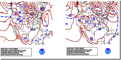
Source NOAA HPC
# 6689
The very last thing that the residents of New England and the Mid-Atlantic states need right now is another storm to deal with, but early indications from NOAA’s HPC (Hydrometeorological Prediction Center) suggest a Nor'easter could be in store by the middle of next week.
PRELIMINARY EXTENDED FORECAST DISCUSSION
NWS HYDROMETEOROLOGICAL PREDICTION CENTER COLLEGE PARK MD
947 AM EDT THU NOV 01 2012
VALID 12Z MON NOV 05 2012 - 12Z THU NOV 08 2012
...NOR'EASTER POSSIBLE FOR MID-ATLANTIC/NEW ENGLAND STATES BY ELECTION DAY INTO NEXT THURSDAY...
<SNIP>
GUIDANCE STILL HAVE SOME TIMING/STRENGTH ISSUES BUT COMMONLY AGREE THAT DEEPER LOW DEVELOPMENT WOULD OCCUR MON-THU AS A FRONTAL WAVE OFF THE SOUTHEAST MOVES SLOWLY OFFSHORE AND UP OFF THE EAST COAST.
THIS WOULD BRING BEST ORGANIZED RAINS FROM THE ERN MID-ATLANTIC TO COASTAL NEW ENGLAND.
A TRACK IN THIS VEIN OFFERS POTENTIAL FOR
HEAVIER SNOWS ACROSS INTERIOR NEW ENGLAND WEDNESDAY/THURSDAY AS THE LOW WRAPS INLAND. INCREASING WINDS ALONG COASTAL NEW ENGLAND (AND POSSIBLY THE COASTAL MID-ATLANTIC STATES IF A MORE WESTERLY
TRACK VERIFIES) TUESDAY ONWARD MAY LEAD TO SOME COASTAL FLOODING AND BEACH EROSION.
IT SHOULD BE NOTED THAT THIS SYSTEM IS
EXPECTED TO BE MUCH WEAKER THAN HURRICANE SANDY AND PRODUCE IMPACTS MUCH LESS EXTREME AND MAINLY AWAY FROM THE REGION MOST
STRONGLY IMPACTED BY SANDY.
Obviously we’ll be watching these developments with keen interest, and the fervent hope that this storm fails to materialize.
Posted by Michael Coston at <a class="timestamp-link" href="http://afludiary.blogspot.ca/2012/11/a-worrisome-mid-week-forecast.html" rel="bookmark" title="permanent link"><abbr class="published" title="2012-11-01T15:08:00-04:00">3:08 PM</abbr>
hat tip Michael Coston
A Worrisome Mid-Week Forecast

Source NOAA HPC
# 6689
The very last thing that the residents of New England and the Mid-Atlantic states need right now is another storm to deal with, but early indications from NOAA’s HPC (Hydrometeorological Prediction Center) suggest a Nor'easter could be in store by the middle of next week.
The two forecast models above show the model runs for November 7th and November 8th.
They show a low pressure area – potentially a winter storm – moving up the eastern seaboard during that time frame.
While six days out is a long way off, and the forecast could certainly change, any deterioration in the weather will make the recovery efforts in New York, New Jersey, and surrounding areas that much more difficult. They show a low pressure area – potentially a winter storm – moving up the eastern seaboard during that time frame.
PRELIMINARY EXTENDED FORECAST DISCUSSION
NWS HYDROMETEOROLOGICAL PREDICTION CENTER COLLEGE PARK MD
947 AM EDT THU NOV 01 2012
VALID 12Z MON NOV 05 2012 - 12Z THU NOV 08 2012
...NOR'EASTER POSSIBLE FOR MID-ATLANTIC/NEW ENGLAND STATES BY ELECTION DAY INTO NEXT THURSDAY...
<SNIP>
GUIDANCE STILL HAVE SOME TIMING/STRENGTH ISSUES BUT COMMONLY AGREE THAT DEEPER LOW DEVELOPMENT WOULD OCCUR MON-THU AS A FRONTAL WAVE OFF THE SOUTHEAST MOVES SLOWLY OFFSHORE AND UP OFF THE EAST COAST.
THIS WOULD BRING BEST ORGANIZED RAINS FROM THE ERN MID-ATLANTIC TO COASTAL NEW ENGLAND.
A TRACK IN THIS VEIN OFFERS POTENTIAL FOR
HEAVIER SNOWS ACROSS INTERIOR NEW ENGLAND WEDNESDAY/THURSDAY AS THE LOW WRAPS INLAND. INCREASING WINDS ALONG COASTAL NEW ENGLAND (AND POSSIBLY THE COASTAL MID-ATLANTIC STATES IF A MORE WESTERLY
TRACK VERIFIES) TUESDAY ONWARD MAY LEAD TO SOME COASTAL FLOODING AND BEACH EROSION.
IT SHOULD BE NOTED THAT THIS SYSTEM IS
EXPECTED TO BE MUCH WEAKER THAN HURRICANE SANDY AND PRODUCE IMPACTS MUCH LESS EXTREME AND MAINLY AWAY FROM THE REGION MOST
STRONGLY IMPACTED BY SANDY.
Posted by Michael Coston at <a class="timestamp-link" href="http://afludiary.blogspot.ca/2012/11/a-worrisome-mid-week-forecast.html" rel="bookmark" title="permanent link"><abbr class="published" title="2012-11-01T15:08:00-04:00">3:08 PM</abbr>