• FluTrackers.com Inc. does not provide medical advice. Information on this web site is collected from various internet resources, and the FluTrackers board of directors makes no warranty to the safety, efficacy, correctness or completeness of the information posted on this site by any author or poster. The information collated here is for instructional and/or discussion purposes only and is NOT intended to diagnose or treat any disease, illness, or other medical condition. Every individual reader or poster should seek advice from their personal physician/healthcare practitioner before considering or using any interventions that are discussed on this website. By continuing to access this website you agree to consult your personal physican before using any interventions posted on this website, and you agree to hold harmless FluTrackers.com Inc., the board of directors, the members, and all authors and posters for any effects from use of any medication, supplement, vitamin or other substance, device, intervention, etc. mentioned in posts on this website, or other internet venues referenced in posts on this website.
  • We are not asking for any donations. Do not donate to any entity who says they are raising funds for us.

Tungurahua volcano erupts in central Ecuador, villagers flee

Pathfinder

Editor, Senior Moderator
Volcano erupts in central Ecuador

QUITO | Sat Dec 4, 2010 2:48pm EST

QUITO (Reuters) - Ecuadorean villagers fled their homes after the Andean country's "Throat of Fire" volcano erupted on Saturday, spewing rocks, gas and ash that prompted officials to declare a maximum alert for nearby communities.

People living within 5 miles/ of the eruption have been evacuated, Felipe Bazan, a government official for emergency situations, told reporters.
...

Located 80 miles/ southeast of capital city Quito, the 16,500-foot/(5,020-meter) Tungurahua is one of eight active volcanoes in the country.


[...]
http://www.reuters.com/article/idUSTRE6B328X20101204
 
Re: Tungurahua volcano erupts in central Ecuador, villagers flee

<CITE class=vcard>Ecuador orders evacuations over active volcano

capt.photo_1291500243521-1-0.jpg

</CITE>
Sat Dec 4, 5:04 PM ET
A view from Banos, Ecuador of the Tungurahua volcano.


? <ABBR class=recenttimedate title=2010-12-04T14:04:16-0800>1 hr 32 mins ago</ABBR>
<!-- end .byline -->

BANOS, Ecuador (AFP) ? Authorities ordered the preventive evacuation Saturday in the southern Ecuadoran town of Bano as they put the country on high alert over a possible major eruption of the Tungurahua volcano.

"People are coming to safe areas in an orderly fashion," Deputy Interior Minister Edwin Jarrin told AFP.
...

A red alert was in effect in Banos and other Andean villages of the 5,029-meter (16,500-foot) volcano, whose name means "throat of fire" in the local Quechua language. It is located some 135 kilometers (85 miles) south of Quito.

Full text:
http://news.yahoo.com/s/afp/20101204/wl_afp/ecuadorvolcano_20101204220419
 
Re: Tungurahua volcano erupts in central Ecuador, villagers flee

Special Bulletin No. 23 Tungurahua volcano

Electronic translation of http://www.igepn.edu.ec/images/coll...anicos/informe especial no 23_04diciembre.pdf

Eruption of the Tungurahua volcano, December 4, 2010
December 4, 2010
Today, Saturday, December 4, 2010, starting at 08h50, seismographs Network
Tungurahua Volcano observation detected a rapid increase in internal vibration or
volcanic tremor, followed immediately by an increased level of bellows and vibration
floor windows are perceived throughout the area of the volcano. At 09h39 the scientific staff of OVT
reported by pyroclastic flows down the streams on the west side and north side
remained in the upper basin of the same. Pyroclastic flow generation continued to
steadily until 15h22. Pyroclastic flows went down mainly by
Vazc?n streams on the north side and CUSU, Mandur, Juive and northwest side. Also
flows were reported in the creeks Rea, and Mapayacu Choglont?s southwest side, although
in smaller numbers.
Larger flows occurred between 10.00 and 11.00 for the streams of Vazc?n, Juive and
Mandur and descended to the middle of the cone. The wind direction during the day
has been predominantly to the south and southeast, so that there are reports of falling
ash on inhabited areas. The volcano remained fairly covered during the morning,
therefore could not accurately determine the maximum height reached by the columns
eruptive, but it was noted that at times exceeded 4 km above the crater.
This increased activity and generation of pyroclastic flows is associated with rapid
increased flow of magma entering the ducts below the volcanic vent
when he finds an open, easy to move quickly took to the crater and
overflow in the form of pyroclastic flows. The current activity is similar
although smaller in magnitude to what happened during the eruption of July 14, 2006, which preceded
eruptions over the whole of the Tungurahua current eruptive process took place on 16 and 17
August 2006.
Strain measurements of the volcanic cone and gas emissions do not show the presence
large volumes of new magma at depth. For this reason, do not expect large
eruptions like those of August 2006 in the short term. However, repetition is not excluded
moderate events like today, as the volcanic vent is open and
any small new magma injection not be opposed to quickly reach
the surface. Ongoing monitoring and interpretation made by the Geophysical Institute on
parameters allow the volcano to hone the predictions of future activity. From
15.30, the internal and external activity of the volcano has decreased markedly and
found at moderate levels and have not generated new pyroclastic flows.
As it did from 09h05 this morning, where authorities were informed
national and local authorities on this activity, the Geophysical Institute will continue to report
the development of the eruptive activity of Tungurahua.
HY / PR / PP / PM / SV

Geophysical Institute
National Polytechnic School
18.30

 
Re: Tungurahua volcano erupts in central Ecuador, villagers flee

Volcano known as the 'Throat of Fire' erupts in Ecuador

<!--startclickprintexclude--><!--endclickprintexclude-->By the CNN Wire Staff<SCRIPT type=text/javascript>cnnAuthor = "By the CNN Wire Staff";</SCRIPT>
<SCRIPT type=text/javascript>if(location.hostname.indexOf( 'edition.' ) > -1) {document.write('December 5, 2010 -- Updated 0228 GMT (1028 HKT)');} else {document.write('December 4, 2010 9:28 p.m. EST');}</SCRIPT>December 4, 2010 9:28 p.m. EST
December 5, 2010 -- Updated 0228 GMT (1028 HKT)

<!--endclickprintinclude--><!-- google_ad_section_end --><!-- google_ad_section_start --><!-- CONTENT --><!--startclickprintinclude--><SCRIPT language=JavaScript type=text/javascript>var clickExpire = "-1";</SCRIPT><!-- REAP --><!--startclickprintexclude--><!--===========IMAGE============-->
t1larg.gi.jpg
<!--===========/IMAGE===========-->
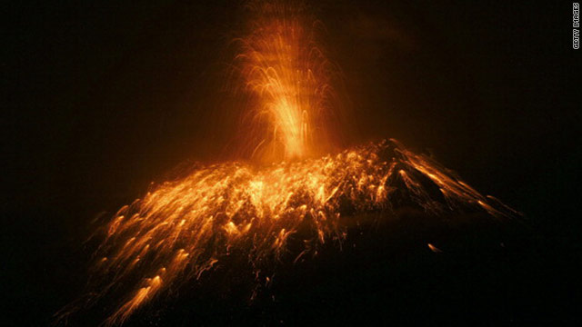
<!--===========CAPTION==========-->View from Cotalo, Ecuador, of the Tungurahua volcano on Saturday.

<!--===========/CAPTION=========--><!--endclickprintexclude--><!-- /REAP -->
(CNN) --

...Residents evacuated the area after the country's National Agency of Risk Control issued a "red alert." The warning was later downgraded to orange, as the volcano became less active.

Activity at Tungurahua -- which means "throat of fire" in the native Quechua language -- peaked Saturday between 8 a.m. and 2 p.m., according to the Geological Institute in Quito.

At one point, the ash cloud reached nearly 3 km (1.9 miles) above the volcano's crater, according to the institute, and lava flowed about 2 km from the crater.


Full text:
http://edition.cnn.com/2010/WORLD/americas/12/04/ecuador.volcano/
 
Back
Top Bottom