Niko
Editor, Senior Moderator
Hurricane RICK Public Advisory
<hr align="left" noshade="noshade" width="100%"> <!-- Stick it all in a table so when you enlarge the graphic, the text doesn't shift all over the page --> <table border="0" cellpadding="0" cellspacing="0" width="100%"> <tbody><tr align="center" valign="top"> <td> <center class="tiny" style="width: 100%; white-space: nowrap;"> Home Public Adv Fcst/Adv Discussion Wind Probs Maps/Charts Archive </center> <hr style="width: 100%;" align="left" noshade="noshade"> </td> </tr> </tbody></table>
000
WTPZ35 KNHC 171436
TCPEP5
BULLETIN
HURRICANE RICK ADVISORY NUMBER 9
NWS TPC/NATIONAL HURRICANE CENTER MIAMI FL EP202009
800 AM PDT SAT OCT 17 2009
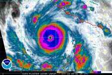
...EXTREMELY DANGEROUS HURRICANE RICK CONTINUING TO STRENGTHEN...
AT 800 AM PDT...1500 UTC...THE CENTER OF HURRICANE RICK WAS LOCATED
NEAR LATITUDE 14.2 NORTH...LONGITUDE 103.0 WEST OR ABOUT 280 MILES
...450 KM...SOUTHWEST OF ACAPULCO MEXICO AND ABOUT 345 MILES...
550 KM...SOUTH-SOUTHEAST OF MANZANILLO MEXICO.
RICK IS MOVING TOWARD THE WEST-NORTHWEST NEAR 12 MPH...19 KM/HR...
AND THIS MOTION IS EXPECTED TO CONTINUE FOR THE NEXT COUPLE OF DAYS.
ON THE FORECAST TRACK...THE CORE OF RICK IS EXPECTED TO REMAIN
OFFSHORE OF THE SOUTHERN COAST OF MEXICO OVER THE WEEKEND AS THE
HURRICANE MOVES GENERALLY PARALLEL TO THE COAST.
MAXIMUM SUSTAINED WINDS ARE NEAR 145 MPH...230 KM/HR...WITH HIGHER
GUSTS. THIS MAKES RICK AN EXTREMELY DANGEROUS CATEGORY FOUR
HURRICANE ON THE SAFFIR-SIMPSON SCALE. ADDITIONAL STRENGTHENING IS
FORECAST...AND RICK COULD BECOME A CATEGORY FIVE HURRICANE LATER
TODAY OR TONIGHT.
HURRICANE FORCE WINDS EXTEND OUTWARD UP TO 40 MILES...65 KM...FROM
THE CENTER...AND TROPICAL STORM FORCE WINDS EXTEND OUTWARD UP TO
115 MILES...185 KM.
ESTIMATED MINIMUM CENTRAL PRESSURE IS 938 MB...27.70 INCHES.
LARGE SWELLS GENERATED BY RICK MAY AFFECT PORTIONS OF THE SOUTHERN
COAST OF MEXICO DURING THE NEXT COUPLE OF DAYS...CAUSING
POTENTIALLY DANGEROUS SURF CONDITIONS.
OUTER RAINBANDS ASSOCIATED WITH RICK WILL CONTINUE TO AFFECT THE
SOUTHERN COAST OF MEXICO THROUGH TONIGHT.
...SUMMARY OF 800 AM PDT INFORMATION...
LOCATION...14.2N 103.0W
MAXIMUM SUSTAINED WINDS...145 MPH
PRESENT MOVEMENT...WEST-NORTHWEST OR 290 DEGREES AT 12 MPH
MINIMUM CENTRAL PRESSURE...938 MB
THE NEXT ADVISORY WILL BE ISSUED BY THE NATIONAL HURRICANE CENTER AT
200 PM PDT.
$$
FORECASTER BEVEN
http://www.nhc.noaa.gov/text/refresh/MIATCPEP5+shtml/171436.shtml


<hr align="left" noshade="noshade" width="100%"> <!-- Stick it all in a table so when you enlarge the graphic, the text doesn't shift all over the page --> <table border="0" cellpadding="0" cellspacing="0" width="100%"> <tbody><tr align="center" valign="top"> <td> <center class="tiny" style="width: 100%; white-space: nowrap;"> Home Public Adv Fcst/Adv Discussion Wind Probs Maps/Charts Archive </center> <hr style="width: 100%;" align="left" noshade="noshade"> </td> </tr> </tbody></table>
000
WTPZ35 KNHC 171436
TCPEP5
BULLETIN
HURRICANE RICK ADVISORY NUMBER 9
NWS TPC/NATIONAL HURRICANE CENTER MIAMI FL EP202009
800 AM PDT SAT OCT 17 2009
...EXTREMELY DANGEROUS HURRICANE RICK CONTINUING TO STRENGTHEN...
AT 800 AM PDT...1500 UTC...THE CENTER OF HURRICANE RICK WAS LOCATED
NEAR LATITUDE 14.2 NORTH...LONGITUDE 103.0 WEST OR ABOUT 280 MILES
...450 KM...SOUTHWEST OF ACAPULCO MEXICO AND ABOUT 345 MILES...
550 KM...SOUTH-SOUTHEAST OF MANZANILLO MEXICO.
RICK IS MOVING TOWARD THE WEST-NORTHWEST NEAR 12 MPH...19 KM/HR...
AND THIS MOTION IS EXPECTED TO CONTINUE FOR THE NEXT COUPLE OF DAYS.
ON THE FORECAST TRACK...THE CORE OF RICK IS EXPECTED TO REMAIN
OFFSHORE OF THE SOUTHERN COAST OF MEXICO OVER THE WEEKEND AS THE
HURRICANE MOVES GENERALLY PARALLEL TO THE COAST.
MAXIMUM SUSTAINED WINDS ARE NEAR 145 MPH...230 KM/HR...WITH HIGHER
GUSTS. THIS MAKES RICK AN EXTREMELY DANGEROUS CATEGORY FOUR
HURRICANE ON THE SAFFIR-SIMPSON SCALE. ADDITIONAL STRENGTHENING IS
FORECAST...AND RICK COULD BECOME A CATEGORY FIVE HURRICANE LATER
TODAY OR TONIGHT.
HURRICANE FORCE WINDS EXTEND OUTWARD UP TO 40 MILES...65 KM...FROM
THE CENTER...AND TROPICAL STORM FORCE WINDS EXTEND OUTWARD UP TO
115 MILES...185 KM.
ESTIMATED MINIMUM CENTRAL PRESSURE IS 938 MB...27.70 INCHES.
LARGE SWELLS GENERATED BY RICK MAY AFFECT PORTIONS OF THE SOUTHERN
COAST OF MEXICO DURING THE NEXT COUPLE OF DAYS...CAUSING
POTENTIALLY DANGEROUS SURF CONDITIONS.
OUTER RAINBANDS ASSOCIATED WITH RICK WILL CONTINUE TO AFFECT THE
SOUTHERN COAST OF MEXICO THROUGH TONIGHT.
...SUMMARY OF 800 AM PDT INFORMATION...
LOCATION...14.2N 103.0W
MAXIMUM SUSTAINED WINDS...145 MPH
PRESENT MOVEMENT...WEST-NORTHWEST OR 290 DEGREES AT 12 MPH
MINIMUM CENTRAL PRESSURE...938 MB
THE NEXT ADVISORY WILL BE ISSUED BY THE NATIONAL HURRICANE CENTER AT
200 PM PDT.
$$
FORECASTER BEVEN
http://www.nhc.noaa.gov/text/refresh/MIATCPEP5+shtml/171436.shtml
Last edited: