

sharon sanders
Editor-in-Chief & President
Global warming heats up infectious diseases
4/07/2008 08:32:00 AM
Posted by Christiaan Adams, Google Earth & Maps Specialist, Google.org, and France Lamy, Program Manager, Google.org
With the World Health Organization (WHO) and World Health Day 2008 drawing attention to climate change and health today, we wanted to show you some cool animated Google Earth layers that illustrate how infectious diseases may spread as the earth warms. Warmer climates make good habitats for mosquitoes. Many diseases, such as dengue fever and malaria, are spread by mosquitoes. As the planet continues to get warmer due to greenhouse gas emissions, these diseases are projected to spread and add to the other burdens of climate change, especially in the developing world.
The Google Earth (KML) file linked below will show you projections for the changes in transmission of dengue fever around the globe and of malaria in Africa and specifically Zimbabwe. These layers were created in collaboration with a number of scientists whose studies provided the data, including Simon Hales, Frank Tanser and Kris Ebi. There's also a layer that shows the estimated deaths related to climate change in the year 2000.
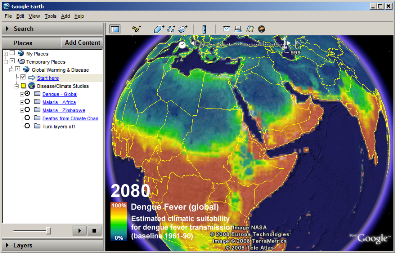
To view the layers, download this KML file and open it in Google Earth on your computer. If you do not have the latest version of Google Earth (4.2) installed, you can download it here.
To see the animations, turn on one layer at a time in the Places panel on the left, by clicking the round button next to the layer name. Once the layer is on, you can play the animation by clicking the play arrow on the right side of the time slider (at the top of the screen).
Clicking the "start here" links or layer names will get you to more information and instructions. Be sure to look at all the layers to see how our warming climate will affect health in ways you might not have expected.
http://blog.google.org/
4/07/2008 08:32:00 AM
Posted by Christiaan Adams, Google Earth & Maps Specialist, Google.org, and France Lamy, Program Manager, Google.org
With the World Health Organization (WHO) and World Health Day 2008 drawing attention to climate change and health today, we wanted to show you some cool animated Google Earth layers that illustrate how infectious diseases may spread as the earth warms. Warmer climates make good habitats for mosquitoes. Many diseases, such as dengue fever and malaria, are spread by mosquitoes. As the planet continues to get warmer due to greenhouse gas emissions, these diseases are projected to spread and add to the other burdens of climate change, especially in the developing world.
The Google Earth (KML) file linked below will show you projections for the changes in transmission of dengue fever around the globe and of malaria in Africa and specifically Zimbabwe. These layers were created in collaboration with a number of scientists whose studies provided the data, including Simon Hales, Frank Tanser and Kris Ebi. There's also a layer that shows the estimated deaths related to climate change in the year 2000.

To view the layers, download this KML file and open it in Google Earth on your computer. If you do not have the latest version of Google Earth (4.2) installed, you can download it here.
To see the animations, turn on one layer at a time in the Places panel on the left, by clicking the round button next to the layer name. Once the layer is on, you can play the animation by clicking the play arrow on the right side of the time slider (at the top of the screen).
Clicking the "start here" links or layer names will get you to more information and instructions. Be sure to look at all the layers to see how our warming climate will affect health in ways you might not have expected.
http://blog.google.org/