In Ida's aftermath, no quick relief in sight for Louisiana
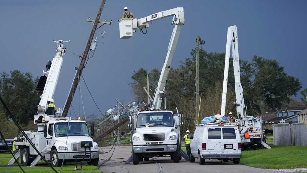
Power and water outages affected hundreds of thousands of people, many of them with no way to get immediate relief.
Author: KEVIN MCGILL (CHEVEL JOHNSON and MELINDA DESLATTE Associated Press)
Published: 3:28 AM CDT September 1, 2021
Updated: 7:57 AM CDT September 1, 2021
NEW ORLEANS — Louisiana residents still reeling from flooding and damage caused by Hurricane Ida scrambled for food, gas, water and relief from the sweltering heat as thousands of line workers toiled to restore electricity and officials vowed to set up more sites where people could get free meals and cool off.
...
New Orleans and the rest of the region were under a heat advisory, with forecasters saying the combination of high temperatures and humidity could make it feel like 106 degrees Fahrenheit (41 degrees Celsius) on Wednesday.
...
-
Parts of New Orleans East has power restored overnight
"We need some solution to power ASAP," Councilwoman Helena Moreno also said.
more..
Leave a comment:
-
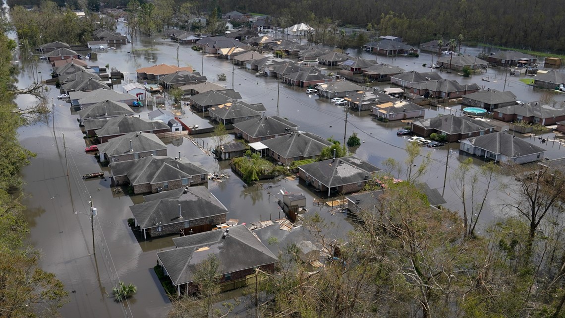
Water rescues still underway after Ida in southeast Louisiana

Leave a comment:
-
Laffite: Rescues underway, water has never ever been this high, officials say
Author: WWL Staff
Published: 10:55 AM CDT August 30, 2021
Updated: 11:01 AM CDT August 30, 2021
JEAN LAFITTE, La. — Up to 400 people were trapped by rising waters in Jean Lafitte, and search and rescue crews have been helping people escape throughout Hurricane Ida's landfall, officials said Monday morning.
Homes in Jean Lafitte that have never been flooded saw eight feet of water, Jefferson Parish Sheriff Joe Lopinto said during an impromptu press conference on Laffite-Larose Highway, where rescue boats are using the flooded roadway to reach Laffite.
... Hurricane Ida's storm surge overpowered Laffite's local levees.
The levee system protecting the New Orleans Metro Area, which doesn't protect Lafitte performed well, Lopinto said.
Leave a comment:
-
NWS New Orleans confirms another levee failure near Plaquemines Parish.. #Ida #lawx
Quote Tweet

From Plaquemines Parish government "Alliance to Oakville Floodgate Evacuate the area immediately. There has been a failure near Hwy 23 in Alliance. Flood waters are heading northbound on Hwy 23 from Alliance."
11:52 PM · Aug 29, 2021·Twitter for Android
https://twitter.com/tropicswx/status/1432204510995247104Leave a comment:
-
Flash Flood Warning issued for Lafitte and Jean Lafitte
17 minutes ago
By Mark Menard
Lafitte and Jean Lafitte under flash flood warning due to levee failure
A flash flood warning has been issued by the National Weather Service for Lafitte and Jean Lafitte until 6:45am Monday morning. The reason is reports by local law enforcement of a levee failure.
The NWS warns the flooding could be deadly, with more than 200 people expected to be affected and in grave danger.

Leave a comment:
-
Hurricane Ida's first confirmed death: Man killed in Ascension Parish after tree falls on home
AUG 29, 2021 - 9:03 PM
BY DAVID J. MITCHELL
https://www.theadvocate.com/baton_rouge/news/article_7276ebe4-0936-11ec-9e08-1bb0b79c70b7.html?utm_medium=notification&utm_sour ce=pushly&utm_campaign=desktop_push
Leave a comment:
-
Ochsner to evacuate 66 patients from two hospitals after Hurricane Ida damages roof, shatters windows
AUG 29, 2021 - 9:30 PM
BY BLAKE PATERSON
Ochsner Health is making plans to evacuate all 66 patients from two hospitals after Hurricane Ida's winds shattered double-pane windows and blew off roofing, sending water trickling into patient rooms.
A "penthouse" portion of roofing above an elevator at Ochsner St. Anne Hospital in Raceland blew off the building, causing water to spill in and shutting down the elevator, Warner said.
... Ochsner Health, the state's largest hospital system, is using back-up generators at most of its facilities in southwest Louisiana. It's also switched over to well water following municipal water issues.
Leave a comment:
-
1 hr
BREAKING
We now know what has caused the New Orleans total power failure: Entergy TRANSMISSION TOWER NEAR BRIDGE CITY HAS COLLAPSED. Wires that spanned the Mississippi River are in the water.It appears it may beTHISTCHYARD.
BREAKING
The multi-megawatt transmission line crosses the Mississippi River & provides power to ALL of #NewOrleans parish. Line apparently in water.
https://twitter.com/SteveNorrisTV/st...703731356139Leave a comment:
-
Broadcastify
Jefferson Parish Louisiana Live Audio FeedsJefferson Parish FireIncidents Displayed Below Provided by Incident Page Network TECHNICAL RESCUE
08/29/21 21:00(LAFITTE - ) FIRE DEPARTMENT ON SCENE MULTIPLE PEOPLE TRAPPED IN A HOUSE FLOODED WITH SEVERAL FEET OF WATER [LOU044] TECHNICAL RESCUE
08/29/21 20:43(JEAN LAFITTE - ) FIRE DEPARTMENT MAKING RESCUES FROM HOMES & TRAILERS DUE TO FLOOD WATERS COMING OVER LEVEES. [LOU009] TECHNICAL RESCUE
08/29/21 20:28(LAFITTE - ) UNITS RESPONDING OCCUPANTS TRAPPED IN THE ATTIC, HOUSE FLOODING [LOU033] TRAFFIC ADVISORY
08/29/21 20:21(LAFITTE - ) FIRE DEPARTMENT REPORTING BRIDGE WAS STRUCK BY A VESSEL, BRIDGE IS IMPASSABLE BY VEHICLE & FOOT. [LOU025] TECHNICAL RESCUE
08/29/21 20:17(LAFITTE - ) FIRE DEPARTMENT ON SCENE RESIDENT TRAPPED IN THE ATTIC OF A HOUSE, HOUSE FILLED 15+ FEET WITH WATER [LOU025] Incidents delayed up to 2 hours.
11750 online listeners at this time:
Leave a comment:
-
22 barges break loose on the Mississippi River as Hurricane Ida slams Louisiana
Parish officials are concerned the boats could damage the parish's water intake system or the oil refineries.
-------------------------------------------------------------------

7:15 PM
The Kerner Swing Bridge in Lafitte was hit by a barge, parish officials say. The bridge does not appear to be structurally sound and any residents still in Lafitte should not attempt to drive across it.
__________________________________________________ __________
Emily comments: It looks like there is an oil tanker in the area, too. (Red) The pulsing blue dot shows a couple of active tug or pusher vessels - unusual in the are right now. That was as of 5 hours ago, so they may be trying to retrieve the barges.

Leave a comment:
-
Hurricane Ida Tropical Cyclone Update NWS National Hurricane Center Miami FL AL092021 200 PM CDT Sun Aug 29 2021
... NOAA Doppler radar imagery indicates that the eye of Ida made a second landfall along the southeastern coast of Louisiana just southwest of Galliano around 200 PM CDT (1900 UTC). Maximum sustained winds are estimated to be 145 mph (235 km/h). The estimated central pressure is 934 mb (27.58 in).

Leave a comment:
-
LIVE TV from Louisiana
NadiFadia
#Louisiana #Ida "Ida toca tierra en Luisiana como huracán categoría 4 "extremadamente peligroso""
LIVE
8.6K viewers
1:05 PM · Aug 29, 2021
Leave a comment:
-
-
758 WTNT34 KNHC 291452 TCPAT4 BULLETIN
Hurricane Ida Advisory Number 14 NWS
National Hurricane Center Miami FL AL092021 1000 AM CDT Sun Aug 29 2021 ...
EYE OF EXTREMELY DANGEROUS CATEGORY 4 HURRICANE IDA NEARING THE SOUTHEASTERN COAST OF LOUISIANA... ...
CATASTROPHIC STORM SURGE AND HURRICANE-FORCE WINDS MOVING ONSHORE...
SUMMARY OF 1000 AM CDT...1500 UTC...
INFORMATION -----------------------------------------------
LOCATION...28.8N 90.0W ABOUT 60 MI...95 KM WSW OF THE MOUTH OF THE MISSISSIPPI RIVER ABOUT 85 MI...135 KM S OF NEW ORLEANS LOUISIANA MAXIMUM SUSTAINED WINDS...150 MPH...240 KM/H PRESENT MOVEMENT...NW OR 320 DEGREES AT 13 MPH...20 KM/H MINIMUM CENTRAL PRESSURE...933 MB...27.55 INCHES WATCHES AND WARNINGS --------------------
CHANGES WITH THIS ADVISORY: The Storm Surge Warning west of Intracoastal City, Louisiana, has been discontinued.
SUMMARY OF WATCHES AND WARNINGS IN EFFECT: A Storm Surge Warning is in effect for... * Intracoastal City Louisiana to the Alabama/Florida border * Vermilion Bay, Lake Borgne, Lake Pontchartrain, Lake Maurepas, and Mobile Bay A Hurricane Warning is in effect for... * Intracoastal City Louisiana to the Mouth of the Pearl River * Lake Pontchartrain, Lake Maurepas, and Metropolitan New Orleans A Tropical Storm Warning is in effect for... * Cameron Louisiana to west of Intracoastal City Louisiana * Mouth of the Pearl River to the Alabama/Florida border A Storm Surge Warning means there is a danger of life-threatening inundation from rising water moving inland from the coastline in the indicated locations. For a depiction of areas at risk, please see the National Weather Service Storm Surge Watch/Warning Graphic, available at hurricanes.gov. This is a life-threatening situation. Persons located within these areas should take all necessary actions to protect life and property from rising water and the potential for other dangerous conditions. Promptly follow evacuation and other instructions from local officials. A Hurricane Warning means that hurricane conditions are expected somewhere within the warning area. A Tropical Storm Warning means that tropical storm conditions are expected somewhere within the warning area. For storm information specific to your area, including possible inland watches and warnings, please monitor products issued by your local National Weather Service forecast office.
DISCUSSION AND OUTLOOK ---------------------- At 1000 AM CDT (1500 UTC), the eye of Hurricane Ida was located by reconnaissance aircraft and NWS Doppler radar near latitude 28.8 North, longitude 90.0 West. Ida is moving toward the northwest near 13 mph (20 km/h). A slightly slower northwestward motion should continue through this evening. A turn toward the north should occur by Monday morning, followed by a slightly faster northeastward motion by Monday night and Tuesday. On the forecast track, the center of Ida will make landfall along the coast of southeastern Louisiana within the hurricane warning area within the next few hours. Ida is then forecast to move well inland over portions of Louisiana and western Mississippi Monday and Monday night, and move across the Tennessee Valley on Tuesday. Reports from NOAA and Air Force Reserve Hurricane Hunter aircraft indicated that the maximum sustained winds are near 150 mph (240 km/h) with higher gusts. Ida is an extremely dangerous category 4 hurricane on the Saffir-Simpson Hurricane Wind Scale. Some slight additional strengthening is still possible before Ida moves onshore along the Louisiana coast. Rapid weakening is expected after landfall. Hurricane-force winds extend outward up to 50 miles (85 km) from the center and tropical-storm-force winds extend outward up to 150 miles (240 km). An elevated NOAA C-MAN station at Southwest Pass recently reported a sustained wind of 105 mph (169 km/h) and a wind gust of 121 mph (194 km/h). A station in Shell Beach, Louisiana, recently reported a sustained wind of 44 mph (70 km/h) and a gust of 52 mph (83 km/h). A NOAA National Ocean Service tide gauge in Shell Beach, Louisiana, recently reported a water level of 5.6 feet above mean higher high water, which is an approximation of inundation in that area. The latest minimum central pressure reported by an Air Force Reserve reconnaissance aircraft is 933 mb (27.55 inches). HAZARDS AFFECTING LAND ---------------------- Key messages for Ida can be found in the Tropical Cyclone Discussion under AWIPS header MIATCDAT4, WMO header WTNT44 KNHC, and on the web at hurricanes.gov/graphics_at4.shtml?key_messages. STORM SURGE: The combination of a dangerous storm surge and the tide will cause normally dry areas near the coast to be flooded by rising waters moving inland from the shoreline. The water could reach the following heights above ground somewhere in the indicated areas if the peak surge occurs at the time of high tide... Port Fourchon, LA to Mouth of the Mississippi River...12-16 ft Morgan City, LA to Port Fourchon, LA...8-12 ft Mouth of the Mississippi River to Bay St. Louis, MS including Lake Borgne...8-12 ft Bay St. Louis, MS to Ocean Springs, MS...6-9 ft Burns Point, LA to Morgan City, LA...5-8 ft Lake Pontchartrain...5-8 ft Ocean Springs, MS to MS/AL border...4-7 ft Lake Maurepas...4-6 ft East of Intracoastal City, LA to Burns Point, LA including Vermilion Bay...3-5 ft MS/AL border to AL/FL border including Mobile Bay...3-5 ft Rockefeller Wildlife Refuge, LA to Intracoastal City, LA...1-3 ft AL/FL border to Okaloosa/Walton County Line including Pensacola Bay...1-3 ft Overtopping of local levees outside of the Hurricane and Storm Damage Risk Reduction System is possible where local inundation values may be higher than those shown above. The deepest water will occur along the immediate coast near and to the east of the landfall location, where the surge will be accompanied by large and dangerous waves. Surge-related flooding depends on the relative timing of the surge and the tidal cycle, and can vary greatly over short distances. For information specific to your area, please see products issued by your local National Weather Service forecast office. WIND: Catastrophic wind damage is likely where the core of Ida moves onshore along the southeast coast of Louisiana in the next few hours. Hurricane conditions will spread inland within the Hurricane Warning area over southeastern Louisiana through tonight. Tropical storm conditions will also spread inland over portions of Louisiana and Mississippi tonight and Monday. RAINFALL: Heavy rainfall from Ida will continue to impact the southeast Louisiana coast this morning, spreading northeast into the Lower Mississippi Valley later today into Monday. Total rainfall accumulations of 10 to 18 inches with isolated maximum amounts of 24 inches are possible across southeast Louisiana into far southern Mississippi through Monday. This is likely to result in life-threatening flash and urban flooding and significant riverine flooding impacts. Ida is forecast to turn to the northeast early Monday and track across the Middle Tennessee Valley and Upper Ohio Valley through Wednesday, producing the following rainfall totals: Coastal Alabama to the far western Florida panhandle: 5 to 10 inches with isolated maximum amounts of 15 inches, today through Tuesday morning. Central Mississippi: 4 to 8 inches with isolated maximum amounts of 12 inches, tonight through Monday night. Middle Tennessee Valley, Upper Ohio Valley, Central Appalachians into the Mid-Atlantic: 3 to 6 inches with isolated higher amounts, Tuesday into Wednesday. These rainfall totals will result in considerable flash and riverine flooding. TORNADOES: Tornadoes will be most likely through Monday over southeast Louisiana, southern Mississippi, southwest Alabama, and the western Florida Panhandle. A few tornadoes are also possible farther north across much of Mississippi and Alabama on Monday. SURF: Swells will affect the northern Gulf coast through early Monday. These swells are likely to cause life-threatening surf and rip current conditions. Please consult products from your local weather office.
NEXT ADVISORY ------------- Next intermediate advisory at 100 PM CDT. Next complete advisory at 400 PM CDT.
Leave a comment:


Leave a comment: