Check out the FAQ,Terms of Service & Disclaimers by clicking the
link. Please register
to be able to post. By viewing this site you are agreeing to our Terms of Service and Acknowledge our Disclaimers.
FluTrackers.com Inc. does not provide medical advice. Information on this web site is collected from various internet resources, and the FluTrackers board of directors makes no warranty to the safety, efficacy, correctness or completeness of the information posted on this site by any author or poster.
The information collated here is for instructional and/or discussion purposes only and is NOT intended to diagnose or treat any disease, illness, or other medical condition. Every individual reader or poster should seek advice from their personal physician/healthcare practitioner before considering or using any interventions that are discussed on this website.
By continuing to access this website you agree to consult your personal physican before using any interventions posted on this website, and you agree to hold harmless FluTrackers.com Inc., the board of directors, the members, and all authors and posters for any effects from use of any medication, supplement, vitamin or other substance, device, intervention, etc. mentioned in posts on this website, or other internet venues referenced in posts on this website.
We are not asking for any donations. Do not donate to any entity who says they are raising funds for us.
Announcement
Collapse
No announcement yet.
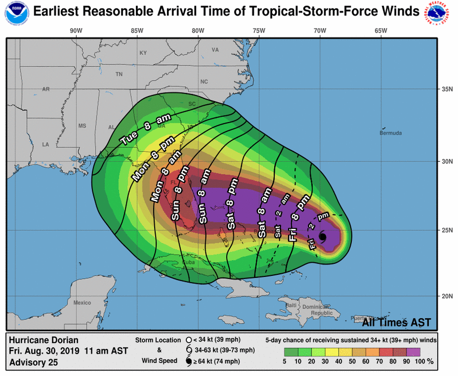
US - Hurricane Dorian - Now forecast to be a category 4 landing in Florida - some links, updates - August 30, 2019
Tropical-storm-force winds from #Dorian could begin in parts of Florida *as early as* Sunday morning. Now is the time to think about what kinds of preparations you might need to make and listen to advice from your local emergency officialshttps://weather.gov/wrn/hurricane-preparedness…
"Safety and security don't just happen, they are the result of collective consensus and public investment. We owe our children, the most vulnerable citizens in our society, a life free of violence and fear." -Nelson Mandela
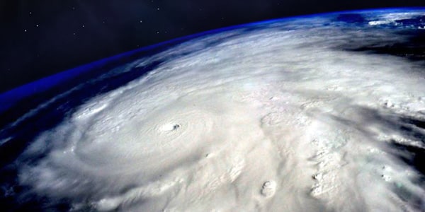
During my 4+ decades tracking hurricanes, I?ve seen how conservative the NHC is in making major track changes. They hate to flip-flop with each new model run so usually they just ?tweak? the centerline track position. Not overnight. I mentioned in my last post 3 scenarios, one being a shift to the east BEFORE Dorian reaches FLA. NHC now has that scenario. Does it mean FLA. is spared? Not yet since much of the state is still in the cone. Plus, the turn hasn?t happened yet! (Remember mass + momentum equation). Dorian is nearing Cat. 5 and will be harder to make radical turn. But that?s what the models say will happen. Sure the threat has lessened for FLA. but it?s not zero. He has a spectacular satellite presentation and is a beast. Let?s hope the model trends prove correct.
...
"Safety and security don't just happen, they are the result of collective consensus and public investment. We owe our children, the most vulnerable citizens in our society, a life free of violence and fear." -Nelson Mandela
"Safety and security don't just happen, they are the result of collective consensus and public investment. We owe our children, the most vulnerable citizens in our society, a life free of violence and fear." -Nelson Mandela
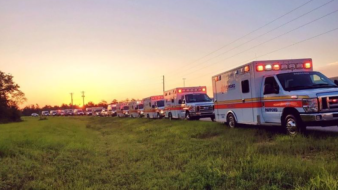
Louisiana sends ambulances to Florida ahead of Hurricane Dorian
"Many states look for Louisiana?s support due to our experience and knowledge in dealing with emergencies,? the GOHSEP director said.
Author: Sean Brennan / WWL-TV
Published: 7:34 PM CDT August 31, 2019
Updated: 7:35 PM CDT August 31, 2019
NEW ORLEANS ? Louisiana has extended a helping hand to Florida ahead of Hurricane Dorian's potential landfall on the state in the coming days.
Ambulance teams made up of nearly three dozens units and 80 medical personnel arrived in Florida from Baton Rouge on Saturday, Louisiana state officials said.
...
"Many states look for Louisiana’s support due to our experience and knowledge in dealing with emergencies,” the GOHSEP director said.
"Safety and security don't just happen, they are the result of collective consensus and public investment. We owe our children, the most vulnerable citizens in our society, a life free of violence and fear." -Nelson Mandela
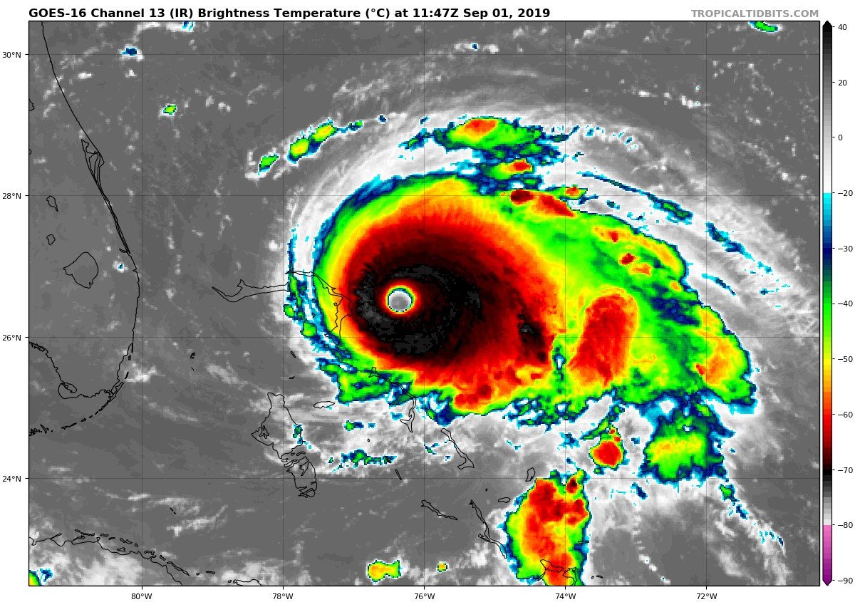
Dorian an Extreme Hurricane - Remains a Threat to Southeast US
Tropical Tidbits
Published on Aug 31, 2019
"Safety and security don't just happen, they are the result of collective consensus and public investment. We owe our children, the most vulnerable citizens in our society, a life free of violence and fear." -Nelson Mandela
Unfortunately, #Dorian has intensified substantially overnight as it approaches the Abaco Islands (pop: 17,000). Estimated pressure from first recon pass is 925mb, and max winds may be at least 160 mph now. The storm does not appear to be able to avoid the island at this point.
The eyewall of #Dorian is reaching the Abaco Islands. Residents there should take immediate shelter. Maximum winds have increased to near 175 mph with gusts over 200 mph. Extreme winds and storm surge will continue for several hours. https://www.nhc.noaa.gov/text/refresh/MIATCUAT5+shtml/011330.shtml?
"Safety and security don't just happen, they are the result of collective consensus and public investment. We owe our children, the most vulnerable citizens in our society, a life free of violence and fear." -Nelson Mandela
Strengthening to a Category 5 earlier today, #HurricaneDorian has become a record-breaking storm as it churns towards the Abaco Islands with devastating winds and storm surge: http://ow.ly/fK4c50vSwS4
"Safety and security don't just happen, they are the result of collective consensus and public investment. We owe our children, the most vulnerable citizens in our society, a life free of violence and fear." -Nelson Mandela
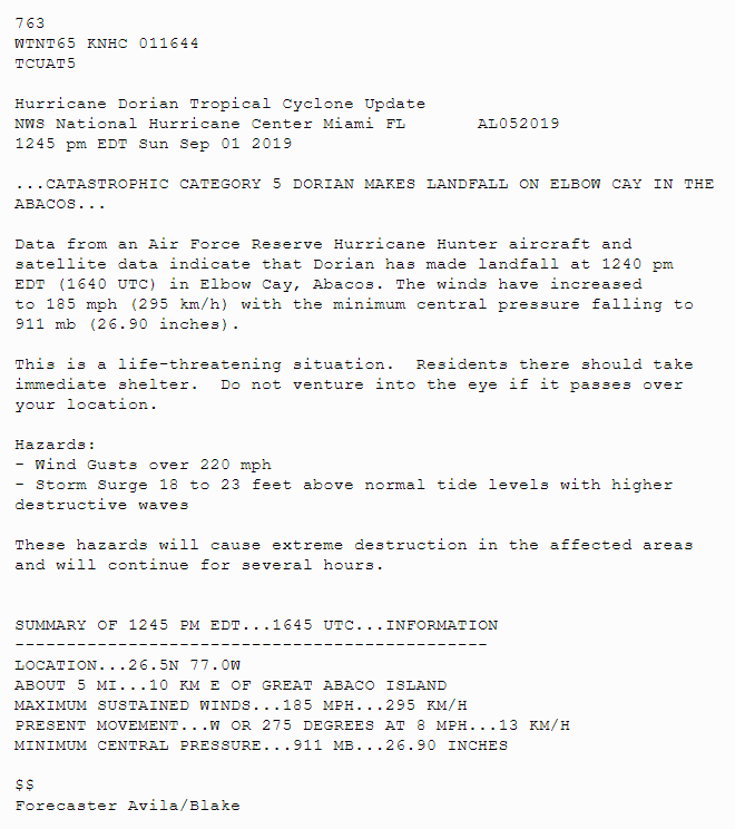
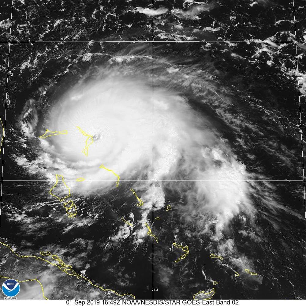
1245pm Update: Hurricane #Dorian has made landfall at Elbow Cay, Abacos. Maximum sustained winds have increased to 185 mph with gusts over 220 mph. http://hurricanes.gov
"Safety and security don't just happen, they are the result of collective consensus and public investment. We owe our children, the most vulnerable citizens in our society, a life free of violence and fear." -Nelson Mandela
Cat 5 Dorian Scouring the Bahamas; Impact to Florida Still Uncertain
Tropical Tidbits
Published on Sep 1, 2019
"Safety and security don't just happen, they are the result of collective consensus and public investment. We owe our children, the most vulnerable citizens in our society, a life free of violence and fear." -Nelson Mandela
Update NWS National Hurricane Center Miami FL AL052019
100 AM EDT Mon Sep 02 2019 ...
CATASTROPHIC STORM SURGE FLOODING LIKELY OCCURRING ON GRAND BAHAMA ISLAND...
This is a life-threatening situation. Residents on Grand Bahama Island should not leave their shelter when the eye passes over, as winds will rapidly increase on the other side of the eye. Residents in the Abacos should continue to stay in their shelter until conditions subside later today. Hazards: - Wind Gusts over 200 mph - Storm Surge 18 to 23 feet above normal tide levels with higher destructive waves These hazards will cause extreme destruction in the affected areas and will continue for several hours.
SUMMARY OF 100 AM EDT...0500 UTC...
INFORMATION ----------------------------------------------
LOCATION...26.6N 78.0W ABOUT 45 MI...70 KM E OF FREEPORT GRAND BAHAMA ISLAND
ABOUT 130 MI...210 KM E OF WEST PALM BEACH FLORIDA
MAXIMUM SUSTAINED WINDS...180 MPH...285 KM/H
PRESENT MOVEMENT...W OR 275 DEGREES AT 5 MPH...7 KM/H
 Tweet
Tweet


 FL Division of Emergency Management
Comment