Announcement

Collapse
No announcement yet.

Matthew downgraded to post-tropical cyclone and heads out to Atlantic

Collapse
X
 
  • Filter
  • Time
  • Show
Clear All
new posts

  • #31
    Saffir-Simpson Hurricane Wind Scale

    Category Sustained Winds Types of Damage Due to Hurricane Winds
    ...
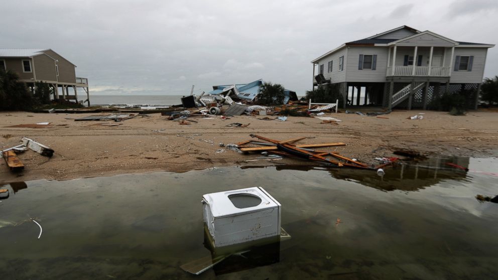
    4(major) 130-156 mph 113-136 kt 209-251 km/h
    Catastrophic damage will occur: Well-built framed homes can sustain severe damage with loss of most of the roof structure and/or some exterior walls. Most trees will be snapped or uprooted and power poles downed. Fallen trees and power poles will isolate residential areas. Power outages will last weeks to possibly months. Most of the area will be uninhabitable for weeks or months.
    ...
    "Safety and security don't just happen, they are the result of collective consensus and public investment. We owe our children, the most vulnerable citizens in our society, a life free of violence and fear."
    -Nelson Mandela

    Comment


    • #32
      Hurricane Matthew Strengthens as Florida Governor Urges Evacuations

      by ALEX JOHNSON and ELIZABETH CHUCK
      ...
      Evacuations were under way in Florida, Georgia and South Carolina after Matthew, which hammered Haiti and strafed Cuba, began battering the Bahamas. The storm killed at least 114 across the Caribbean, including a staggering 108 in Haiti, and forecasters warned of "life-threatening" devastation as it crossed the Bahamas.
      ...
      "Sadly, this is one of the most dire predictions I've ever given for a hurricane forecast," NBC News meteorologist Bill Karins said. "The devastation that is left behind is going to take us weeks to clean up, and a lot of people are going to need help."
      ...
      Scott pleaded with residents to follow evacuation orders.

      "Do not surf. Do not go on the beach. This will kill you," he said Thursday. "There is no reason not to leave."

      Scott warned Floridians that projected winds of 100 to 150 mph will destroy houses and "millions will lose power, possibly for a long period of time."

      "My goal is to make sure everyone is prepared," he said, telling residents to fill up on gas and supplies now. "Evacuate, evacuate, evacuate."
      ...
      Regardless of whether it's a direct hit, Scott said the impact on Florida "will be catastrophic."
      ...
      Up to 1.5 million Americans were fleeing as Hurricane Matthew, which has already killed more than 100 across the Caribbean, regained strength as a Category 4 storm Thursday and eyed south Atlantic coastal areas. The storm, which had dipped to a Category 3, roared back up Category 4 late Thursday morning, with maximum sustained winds at 140 mph, the National Hurricane Center said.
      "Safety and security don't just happen, they are the result of collective consensus and public investment. We owe our children, the most vulnerable citizens in our society, a life free of violence and fear."
      -Nelson Mandela

      Comment


      • #33
        000
        WTNT34 KNHC 062051
        TCPAT4

        BULLETIN
        HURRICANE MATTHEW ADVISORY NUMBER 35
        NWS NATIONAL HURRICANE CENTER MIAMI FL AL142016
        500 PM EDT THU OCT 06 2016

        ...EYE OF EXTREMELY DANGEROUS HURRICANE MATTHEW ABOUT TO HIT
        FREEPORT IN THE BAHAMAS...
        ...POTENTIALLY DISASTROUS IMPACTS FOR FLORIDA...


        SUMMARY OF 500 PM EDT...2100 UTC...INFORMATION
        ----------------------------------------------
        LOCATION...26.2N 78.6W
        ABOUT 25 MI...40 KM SSE OF FREEPORT GRAND BAHAMA ISLAND
        ABOUT 100 MI...160 KM ESE OF WEST PALM BEACH FLORIDA
        MAXIMUM SUSTAINED WINDS...140 MPH...220 KM/H
        PRESENT MOVEMENT...NW O
        R 325 DEGREES AT 13 MPH...20 KM/H
        MINIMUM CENTRAL PRESSURE...938 MB...27.70 INCHES


        WATCHES AND WARNINGS
        --------------------
        CHANGES WITH THIS ADVISORY:

        The Hurricane Warning has been extended northward to South Santee
        River, South Carolina.

        A Tropical Storm Warning has been issued from north of South Santee
        River to Surf City, North Carolina.

        The Government of the Bahamas has discontinued the Hurricane Warning
        for the Central Bahamas.

        SUMMARY OF WATCHES AND WARNINGS IN EFFECT:

        A Hurricane Warning is in effect for...
        * Northwestern Bahamas, including the Abacos, Andros Island, Berry
        Islands, Bimini, Eleuthera, Grand Bahama Island, and New Providence
        * North of Golden Beach to South Santee River
        * Lake Okeechobee

        A Tropical Storm Warning is in effect for...
        * Chokoloskee to Golden Beach
        * Florida Keys from Seven Mile Bridge eastward
        * Florida Bay
        * Anclote River to Suwannee River
        * North of South Santee River to Surf City

        A Tropical Storm Watch is in effect for...
        * North of Chokoloskee to Anclote River

        Interests elsewhere in the Florida Peninsula, the Florida Keys, and
        in the Carolinas should monitor the progress of Matthew.

        A Hurricane Warning means that hurricane conditions are expected
        somewhere within the warning area. A warning is typically issued
        36 hours before the anticipated first occurrence of tropical-storm-
        force winds, conditions that make outside preparations difficult or
        dangerous. Preparations to protect life and property should be
        rushed to completion.

        A Tropical Storm Warning means that tropical storm conditions are
        expected somewhere within the warning area within 36 hours.

        For storm information specific to your area in the United States,
        including possible inland watches and warnings, please monitor
        products issued by your local National Weather Service forecast
        office. For storm information specific to your area outside the
        United States, please monitor products issued by your national
        meteorological service.


        DISCUSSION AND 48-HOUR OUTLOOK
        ------------------------------
        At 500 PM EDT (2100 UTC), the eye of Hurricane Matthew was located
        near latitude 26.2 North, longitude 78.6 West. The hurricane
        is moving toward the northwest near 14 mph (22 km/h), and this
        general motion is expected to continue tonight with a turn toward
        the north-northwest early Friday. On the forecast track, the
        eye of Matthew should move near or over Freeport in the Bahamas
        in the next hour or so, and move close to or over the east coast
        of the Florida peninsula through Friday night.


        Maximum sustained winds are near 140 mph (220 km/h) with higher
        gusts. Matthew is a category 4 hurricane on the Saffir-Simpson
        Hurricane Wind Scale. Some fluctuations in intensity are likely
        while the hurricane moves toward the coast of Florida.


        Hurricane-force winds extend outward up to 60 miles (95 km) from the
        center and tropical-storm-force winds extend outward up to 185 miles
        (295 km).
        Settlement Point in the Bahamas, recently reported a
        sustained wind of 54 mph (87 km/h) with a gust of 62 mph (100
        km/hr).

        The minimum central pressure reported by a NOAA Hurricane Hunter
        plane was 938 mb (27.70 inches).


        HAZARDS AFFECTING LAND
        ----------------------
        WIND: Hurricane conditions will continue over portions of the
        northwestern Bahamas this evening.

        Hurricane conditions are expected to first reach the hurricane
        warning area in Florida this evening and will spread northward
        within the warning area through Friday. Tropical storm conditions
        will continue to spread northward in the warning area along the
        Florida east coast tonight and Friday.

        Hurricane conditions are expected to spread northward in the warning
        area in Georgia and South Carolina Friday night and Saturday with
        tropical storm conditions expected on Friday.

        Winds increase rapidly in elevation in a tropical cyclone.
        Residents in high-rise buildings should be aware that the winds at
        the top of a 30-story building will be, on average, about one
        Saffir-Simpson category higher than the winds near the surface.

        Tropical storm conditions are expected in the tropical storm warning
        area in the Carolinas on Friday night and Saturday.

        STORM SURGE: The combination of a dangerous storm surge and large
        and destructive waves could raise water levels by as much as the
        following amounts above normal tide levels...

        Northwestern Bahamas...10 to 15 feet

        The water could reach the following heights above ground if the peak
        surge occurs at the time of high tide...

        Sebastian Inlet, Florida, to Edisto Beach, South Carolina, including
        portions of the St. Johns River...7 to 11 ft
        Edisto Beach to South Santee River, South Carolina...4 to 6 ft
        Deerfield Beach to Sebastian Inlet, Florida...4 to 6 ft
        South Santee River, South Carolina, to Cape Fear, North Carolina...2
        to 4 ft
        Virginia Key to Deerfield Beach, Florida...1 to 3 ft

        Surge-related flooding depends on the relative timing of the surge
        and the tidal cycle, and can vary greatly over short distances.
        Large waves generated by Matthew will cause water rises to occur
        well in advance of and well away from the track of the center.

        The combination of a dangerous storm surge and the tide will cause
        normally dry areas near the coast to be flooded by rising waters
        moving inland from the shoreline. There is a danger of life-
        threatening inundation during the next 36 hours along the Florida
        east coast, the Georgia coast, and the South Carolina coast from
        Deerfield Beach, Florida, to South Santee River, South Carolina.
        There is the possibility of life-threatening inundation during the
        next 48 hours from north of South Santee River, South Carolina, to
        Cape Fear, North Carolina. For a depiction of areas at risk, please
        see the Prototype National Weather Service Storm Surge Watch/Warning
        Graphic. For information specific to your area, please see products
        issued by your local National Weather Service forecast office.

        The Prototype Storm Surge Watch/Warning Graphic is a depiction of
        areas that would qualify for inclusion under a storm surge watch or
        warning currently under development by the National Weather Service
        and planned for operational use in 2017. The Prototype Graphic is
        available at hurricanes.gov.

        RAINFALL: Matthew is expected to produce total rainfall amounts in
        the following areas:

        The central and northern Bahamas...8 to 12 inches, isolated 15
        inches
        Coastal eastern Florida, Georgia, South Carolina, and southeast
        North Carolina....5 to 10 inches, isolated 12 inches

        Rainfall should diminish across central and eastern Cuba with
        isolated additional amounts of 1 to 2 inches possible through this
        evening.

        TORNADOES: An isolated tornado or two is possible along the
        east-central Florida coast tonight.

        SURF: Swells generated by Matthew will continue to affect portions
        of the north coast of Cuba and the Bahamas during the next few days,
        and will spread northward along the east coast of Florida and the
        southeast U.S. coast through the weekend. These swells will likely
        cause life-threatening surf and rip current conditions. Please
        consult products from your local weather office.


        NEXT ADVISORY
        -------------
        Next intermediate advisory at 800 PM EDT.
        Next complete advisory at 1100 PM EDT.

        $$
        Forecaster Avila


        ------------------------------------------------------------------------------------------------

        000
        WTNT44 KNHC 062052
        TCDAT4

        HURRICANE MATTHEW DISCUSSION NUMBER 35
        NWS NATIONAL HURRICANE CENTER MIAMI FL AL142016
        500 PM EDT THU OCT 06 2016

        A NOAA Hurricane Hunter plane just reached Matthew and measured 121
        kt at the 700-mb level and a minimum pressure of of 936 mb. Until
        the plane finishes sampling the circulation, the initial intensity
        is kept at 120 kt. There some indications that an outer eyewall is
        trying to form, and perhaps an eyewall cycle will occur. If so, some
        weakening could occur, but there could also be fluctuations in
        intensity while the hurricane moves toward the east coast of Florida
        that are not explicitly shown here. After 24 hours, the combination
        of land interaction and a significant increase in the shear should
        cause weakening. The NHC intensity forecast is very similar to the
        SHIPS guidance during the next day or so, and it follows the trend
        of the consensus thereafter.

        Satellite and aircraft fixes show that Matthew is still moving
        toward the northwest or 325 degrees at 11 kt. The steering flow has
        not changed, and Matthew should continue to move around the western
        periphery of the subtropical ridge located over the western Atlantic
        during the next 24 to 36 hours. This portion of the NHC forecast is
        very close to the multi-model consensus. After that time, the
        hurricane will become embedded within the mid-latitude westerlies
        and should turn sharply eastward for a day or so. Then the steering
        pattern is forecast to change again, and the track forecast becomes
        highly uncertain. Both the GFS and the ECMWF turn a much weaker
        Matthew southward and southwestward. The NHC forecast follows the
        southwestward trend, and is in the middle of these two global
        models.

        KEY MESSAGES:

        1. Matthew is likely to produce devastating impacts from storm
        surge, extreme winds, and heavy rains in the northwestern Bahamas
        today, and along extensive portions of the east coast of Florida
        tonight.

        2. Evacuations are not just a coastal event. Strong winds will
        occur well inland from the coast, and residents of mobile
        homes under evacuation orders are urged to heed those orders.

        3. Hurricane winds increase very rapidly with height, and residents
        of high-rise buildings are at particular risk of strong winds. Winds
        at the top of a 30-story building will average one Saffir-Simpson
        category higher than the winds near the surface.

        4. When a hurricane is forecast to take a track roughly parallel
        to a coastline, as Matthew is forecast to do from Florida through
        South Carolina, it becomes very difficult to specify impacts at
        any one location. Only a small deviation of the track
        to the left of the NHC forecast could bring the core of a major
        hurricane onshore within the hurricane warning area in Florida and
        Georgia. Modest deviations to the right could keep much of the
        hurricane-force winds offshore. Similarly large variations in
        impacts are possible in the hurricane watch and warning areas in
        northeast Georgia and South Carolina.


        5. The National Hurricane Center is issuing Potential Storm Surge
        Flooding Maps, and Prototype Storm Surge Watch/Warning Graphics for
        Matthew. It is important to remember that the Potential Storm Surge
        Flooding Map does not represent a forecast of expected inundation,
        but rather depicts a reasonable worst-case scenario - the amount of
        inundation that has a 10 percent chance of being exceeded. In
        addition, because the Flooding Map is based on inputs that extend
        out only to about 72 hours, it best represents the flooding
        potential in those locations within the watch and warning areas in
        Florida and Georgia.

        FORECAST POSITIONS AND MAX WINDS

        INIT 06/2100Z 26.2N 78.6W 120 KT 140 MPH
        12H 07/0600Z 27.6N 79.9W 115 KT 130 MPH
        24H 07/1800Z 29.6N 81.0W 110 KT 125 MPH
        36H 08/0600Z 31.2N 81.0W 95 KT 110 MPH
        48H 08/1800Z 32.1N 80.0W 80 KT 90 MPH
        72H 09/1800Z 31.5N 76.5W 60 KT 70 MPH
        96H 10/1800Z 29.0N 76.5W 50 KT 60 MPH
        120H 11/1800Z 27.5N 77.5W 40 KT 45 MPH

        $$
        Forecaster Avila

        "Safety and security don't just happen, they are the result of collective consensus and public investment. We owe our children, the most vulnerable citizens in our society, a life free of violence and fear."
        -Nelson Mandela

        Comment


        • #34
          Local Statement for MATTHEW (Melbourne, FL)

          Home Public Adv Fcst Adv Discussion Wind Probs Graphics Archive

          U.S. Watch/Warning Local Statements UPDATE

          000
          WTUS82 KMLB 062201
          HLSMLB
          FLZ041-044>047-053-054-058-059-064-141-144-147-070615-

          HURRICANE MATTHEW LOCAL STATEMENT ADVISORY NUMBER 35
          NATIONAL WEATHER SERVICE MELBOURNE FL AL142016
          601 PM EDT THU OCT 6 2016

          THIS PRODUCT COVERS EAST CENTRAL FLORIDA

          ...STRONGEST HURRICANE TO AFFECT THIS AREA IN DECADES
          FAST APPROACHING...


          NEW INFORMATION
          ---------------

          * CHANGES TO WATCHES AND WARNINGS:
          - NONE

          * CURRENT WATCHES AND WARNINGS:
          - A HURRICANE WARNING REMAINS IN EFFECT FOR INLAND VOLUSIA
          COUNTY...ORANGE...SEMINOLE...SOUTHERN BREVARD
          COUNTY...OSCEOLA...INDIAN RIVER...OKEECHOBEE...ST.
          LUCIE...MARTIN...COASTAL VOLUSIA COUNTY AND NORTHERN BREVARD
          COUNTY
          - A TROPICAL STORM WARNING REMAINS IN EFFECT FOR NORTHERN LAKE
          COUNTY...SOUTHERN LAKE COUNTY

          * STORM INFORMATION:
          - ABOUT 200 MILES SOUTHEAST OF CAPE CANAVERAL FL OR ABOUT 140
          MILES SOUTHEAST OF FORT PIERCE FL
          - 26.2N 78.6W
          - STORM INTENSITY 140 MPH
          - MOVEMENT NORTHWEST OR 325 DEGREES AT 13 MPH

          SITUATION OVERVIEW
          ------------------
          DANGEROUS HURRICANE MATTHEW CONTINUES TO MOVE NORTHWESTWARD OVER
          THE NORTHERN BAHAMAS AND IS FORECAST TO MOVE VERY NEAR OR OVER THE
          EAST CENTRAL COAST OF FLORIDA LATE TONIGHT AND INTO FRIDAY.

          CONDITIONS WILL CONTINUE TO DETERIORATE THROUGH THE REMAINDER OF THE
          EVENING AND ESPECIALLY OVERNIGHT AS THE OUTER RAINBANDS FROM MATTHEW
          CONTINUE TO INCREASE IN BOTH NUMBER AND INTENSITY. EXTREMELY
          DANGEROUS, LIFE-THREATENING WEATHER CONDITIONS ARE FORECAST IN THE
          NEXT 12 TO 24 HOURS. THE CENTER OF HURRICANE MATTHEW CONTAINING THE
          STRONGEST WIND GUSTS, STORM SURGE AND HEAVY RAIN SQUALLS WILL MOVE
          VERY NEAR OR OVER PORTIONS OF THE EAST CENTRAL FLORIDA COASTLINE VERY
          EARLY FRIDAY MORNING AND INTO THE AFTERNOON.

          WIDESPREAD EXTENSIVE TO DEVASTATING WIND IMPACTS WILL BE FELT.
          AIRBORNE DEBRIS LOFTED BY EXTREME WINDS WILL BE CAPABLE OF BREACHING
          STRUCTURES, UNPROTECTED WINDOWS AND VEHICLES. EFFECTS SUCH AS THESE
          HAVE NOT BEEN EXPERIENCED IN CENTRAL FLORIDA IN DECADES. LOCAL
          CONDITIONS WILL LIKELY EXCEED WHAT OCCURRED DURING THE HURRICANES OF
          2004. EXPECT WIDESPREAD POWER OUTAGES.

          INLAND FROM THE COASTLINE, THE THREAT IS HIGH FOR SUSTAINED HURRICANE
          FORCE WINDS FOR A PERIOD OF TIME FRIDAY MORNING WITH A HIGH THREAT FOR
          STRONG TROPICAL STORM FORCE WINDS FARTHER INLAND OVER LAKE COUNTY.

          WITH AN EXPECTED TRACK CLOSE TO THE COASTLINE, THE POTENTIAL FOR LIFE
          THREATENING STORM SURGE FLOODING IS HIGH TO EXTREME. STORM SURGE
          FLOODING OF 7 TO 11 FEET IS EXPECTED ALONG THE BARRIER ISLANDS OF
          VOLUSIA AND BREVARD COUNTIES, WITH 4 TO 7 FEET OF INUNDATION EXPECTED
          OVER INDIAN RIVER, MARTIN, AND SAINT LUCIE COUNTY BARRIER ISLANDS.

          LARGE BREAKING WAVES ALONG BEACHES WILL PEAK BETWEEN 12 TO 18 FEET AND
          PRODUCE ROUGH, POUNDING SURF RESULTING IN A SIGNIFICANT HAZARD OF
          COASTAL FLOODING FROM DUNE BREACHING, ALONG WITH VERY SEVERE BEACH
          SCOURING AND SAND DUNE EROSION.

          SIGNIFICANT DOWNWIND PILING AND SURGING OF WATER WILL OCCUR WITHIN THE
          INTRACOASTAL WATERWAY, LAGOONS, AND INLETS. THE CLOSE APPROACH OF
          MATTHEW'S EYE TO THE EAST CENTRAL FLORIDA COAST MEANS PROPERTIES
          FACING EAST AND WEST ALONG THE INTRACOASTAL WATERWAY WILL BE
          SUSCEPTIBLE TO WIND DRIVEN PILING OF WATER. ADDITIONALLY, WIND DRIVEN
          PILING OF WATER WILL BE POSSIBLE ALONG THE BANKS OF THE SAINT JOHNS
          RIVER IN LAKE AND VOLUSIA COUNTIES.

          HEAVY RAIN, ESPECIALLY IN SQUALLS, WILL INCREASE IN COVERAGE AND
          FREQUENCY ACROSS EAST CENTRAL FLORIDA THURSDAY INTO FRIDAY. WIDESPREAD
          RAINFALL TOTALS OF 5 TO 8 INCHES ARE EXPECTED WITH LOCALLY HIGHER
          AMOUNTS, ESPECIALLY ALONG THE COAST. SATURATED SOILS IN MANY AREAS
          FROM HEAVY SEPTEMBER AND EARLY OCTOBER RAINFALL WILL HOLD VERY LITTLE
          ADDITIONAL WATER BEFORE WATER QUICKLY BEGINS TO POND, ESPECIALLY IN
          LOW LYING AND URBAN AREAS. STANDING WATER WILL BE CAPABLE OF QUICKLY
          RISING, ESPECIALLY IN FLOOD PRONE AREAS, AND COULD ENTER HOMES AND
          BUSINESSES DURING MATTHEW'S PASSAGE.

          RESIDENTS AND VISITORS TO EAST CENTRAL FLORIDA ARE STRONGLY ENCOURAGED
          TO MONITOR THE LATEST TRACK AND INTENSITY FORECASTS FROM THE NATIONAL
          HURRICANE CENTER. ENSURE FINAL PREPARATIONS ACCORDING TO YOUR
          READINESS PLANS HAVE BEEN COMPLETED.

          POTENTIAL IMPACTS
          -----------------

          * WIND:
          PROTECT AGAINST LIFE-THREATENING WIND HAVING POSSIBLE DEVASTATING
          IMPACTS ACROSS THE COASTAL COUNTIES OF EAST CENTRAL FLORIDA.
          POTENTIAL IMPACTS IN THIS AREA INCLUDE:
          - STRUCTURAL DAMAGE TO STURDY BUILDINGS, SOME WITH COMPLETE ROOF
          AND WALL FAILURES. COMPLETE DESTRUCTION OF MOBILE HOMES. DAMAGE
          GREATLY ACCENTUATED BY LARGE AIRBORNE PROJECTILES. LOCATIONS
          MAY BE UNINHABITABLE FOR WEEKS OR MONTHS.
          - NUMEROUS LARGE TREES SNAPPED OR UPROOTED ALONG WITH FENCES AND
          ROADWAY SIGNS BLOWN OVER.
          - MANY ROADS IMPASSABLE FROM LARGE DEBRIS, AND MORE WITHIN URBAN
          OR HEAVILY WOODED PLACES. MANY BRIDGES, CAUSEWAYS, AND ACCESS
          ROUTES IMPASSABLE.
          - WIDESPREAD POWER AND COMMUNICATIONS OUTAGES.

          * SURGE:
          PROTECT AGAINST LIFE-THREATENING SURGE HAVING POSSIBLE DEVASTATING
          IMPACTS ACROSS COASTAL AREAS OF EAST CENTRAL FLORIDA. POTENTIAL IMPACTS
          IN THIS AREA INCLUDE:
          - WIDESPREAD DEEP INUNDATION, WITH STORM SURGE FLOODING GREATLY
          ACCENTUATED BY POWERFUL BATTERING WAVES. STRUCTURAL DAMAGE TO
          BUILDINGS, WITH MANY WASHING AWAY. DAMAGE GREATLY COMPOUNDED
          FROM CONSIDERABLE FLOATING DEBRIS. LOCATIONS MAY BE
          UNINHABITABLE FOR AN EXTENDED PERIOD.
          - NEAR-SHORE ESCAPE ROUTES AND SECONDARY ROADS WILL BE WASHED OUT
          OR SEVERELY FLOODED. FLOOD CONTROL SYSTEMS AND BARRIERS MAY
          BECOME STRESSED.
          - EXTREME BEACH EROSION. NEW SHORELINE CUTS POSSIBLE.
          - MASSIVE DAMAGE TO MARINAS, DOCKS, BOARDWALKS, PIERS, AND OTHER
          COASTAL STRUCTURES. NUMEROUS SMALL CRAFT BROKEN AWAY FROM
          MOORINGS WITH MANY LIFTED ONSHORE AND STRANDED.

          * FLOODING RAIN:
          PROTECT AGAINST LIFE-THREATENING RAINFALL FLOODING HAVING POSSIBLE
          EXTENSIVE IMPACTS ACROSS EAST CENTRAL FLORIDA. POTENTIAL
          IMPACTS INCLUDE:
          - MAJOR RAINFALL FLOODING MAY PROMPT MANY EVACUATIONS AND RESCUES.
          - RIVERS AND TRIBUTARIES MAY RAPIDLY OVERFLOW THEIR BANKS IN
          MULTIPLE PLACES. SMALL STREAMS, CREEKS, CANALS, AND DITCHES MAY
          BECOME DANGEROUS RIVERS. FLOOD CONTROL SYSTEMS AND BARRIERS MAY
          BECOME STRESSED.
          - FLOOD WATERS CAN ENTER MANY STRUCTURES WITHIN MULTIPLE
          COMMUNITIES, SOME STRUCTURES BECOMING UNINHABITABLE OR WASHED
          AWAY. MANY PLACES WHERE FLOOD WATERS MAY COVER ESCAPE ROUTES.
          STREETS AND PARKING LOTS BECOME RIVERS OF MOVING WATER WITH
          UNDERPASSES SUBMERGED. DRIVING CONDITIONS BECOME DANGEROUS.
          MANY ROAD AND BRIDGE CLOSURES WITH SOME WEAKENED OR WASHED OUT.

          * TORNADOES:
          PROTECT AGAINST A DANGEROUS TORNADO EVENT HAVING POSSIBLE SIGNIFICANT
          IMPACTS ACROSS EAST CENTRAL FLORIDA. POTENTIAL IMPACTS
          INCLUDE:
          - THE OCCURRENCE OF ISOLATED TORNADOES CAN HINDER
          THE EXECUTION OF EMERGENCY PLANS DURING TROPICAL EVENTS.
          - SEVERAL PLACES MAY EXPERIENCE TORNADO DAMAGE WITH A FEW
          LOCATIONS SEEING CONSIDERABLE DAMAGE, POWER LOSS, AND
          COMMUNICATIONS FAILURES.
          - LOCATIONS COULD REALIZE ROOFS TORN OFF FRAME HOUSES, MOBILE
          HOMES DEMOLISHED, BOXCARS OVERTURNED, LARGE TREES SNAPPED OR
          UPROOTED, VEHICLES TUMBLED, AND SMALL BOATS TOSSED ABOUT.
          DANGEROUS PROJECTILES CAN ADD TO THE TOLL.

          PRECAUTIONARY/PREPAREDNESS ACTIONS
          ----------------------------------
          OUTSIDE PREPARATIONS SHOULD BE WRAPPED UP AS SOON AS POSSIBLE BEFORE
          WEATHER CONDITIONS DETERIORATE. ANY REMAINING EVACUATIONS AND
          RELOCATIONS SHOULD BE COMPLETED BEFORE THE ONSET OF TROPICAL STORM
          FORCE WINDS WHICH ARE EXPECTED TO BEGIN SHORTLY.

          CHECK-IN WITH YOUR EMERGENCY POINTS OF CONTACT AMONG FAMILY, FRIENDS,
          AND WORKMATES. INFORM THEM OF YOUR STATUS AND WELL-BEING. LET THEM
          KNOW HOW YOU INTEND TO RIDE OUT THE STORM AND WHEN YOU PLAN TO
          CHECK-IN AGAIN.

          KEEP CELL PHONES WELL CHARGED AND HANDY. ALSO, CELL PHONE CHARGERS
          FOR AUTOMOBILES CAN BE HELPFUL AFTER THE STORM. LOCATE YOUR CHARGERS
          AND KEEP THEM WITH YOUR CELL PHONE.

          CLOSELY MONITOR NOAA WEATHER RADIO OR OTHER LOCAL NEWS OUTLETS FOR
          OFFICIAL STORM INFORMATION.

          * ADDITIONAL SOURCES OF INFORMATION:
          - FOR INFORMATION ON APPROPRIATE PREPARATIONS SEE READY.GOV
          - FOR INFORMATION ON CREATING AN EMERGENCY PLAN SEE GETAGAMEPLAN.ORG
          - FOR ADDITIONAL DISASTER PREPAREDNESS INFORMATION SEE REDCROSS.ORG

          NEXT UPDATE
          -----------

          THE NEXT LOCAL STATEMENT WILL BE ISSUED BY THE NATIONAL WEATHER
          SERVICE IN MELBOURNE FL AROUND 12 AM EDT, OR SOONER IF CONDITIONS
          WARRANT.

          $$

          ULRICH

          "Safety and security don't just happen, they are the result of collective consensus and public investment. We owe our children, the most vulnerable citizens in our society, a life free of violence and fear."
          -Nelson Mandela

          Comment


          • #35
            Gov. Scott On Hurricane Matthew: ?It?s A Monster, Get Out?

            October 6, 2016 7:20 PM

            MIAMI (CBSMiami) ? Florida Gov. Rick Scott says time is running out for residents in evacuation zones as Hurricane Matthew moves nearer to the state?s east coast.

            The governor met with National Hurricane Center officials ar around 5:15 p.m. and his tune hasn?t changed.

            ?We are already starting to see the impacts, and it?s a monster,? he said.

            The hurricane is making its way into South and Central Florida Thursday night. He urged residents to have their phones on them for important alerts, including tornado advisories.

            ?If you are Brevard County or north, and in an evacuation zone, you still have time to leave,? he said. ?Get out.?
            ...
            Florida Gov. Rick Scott says time is running out for residents in evacuation zones as Hurricane Matthew moves nearer to the east coast.
            "Safety and security don't just happen, they are the result of collective consensus and public investment. We owe our children, the most vulnerable citizens in our society, a life free of violence and fear."
            -Nelson Mandela

            Comment


            • #36
              Gov. Scott Issues Updates on Hurricane Matthew Preparedness and Response Efforts as Storm Impacts Florida

              On October 6, 2016, in News Releases, by Staff


              TALLAHASSEE, Fla. ? Today, Governor Rick Scott met with emergency management officials in Tallahassee and Stuart and St. Augustine as the state prepares for Hurricane Matthew, a life-threatening category four storm. Florida remains under both tropical storm and hurricane watches and warnings. Governor Scott has remained in constant communication with state and local leaders, utility companies, sheriffs, and volunteer organizations who are working to ensure the state is prepared for the storm.
              EVACUATIONS
              • More than 1.5 million Floridians are currently in evacuation zones.
              • Brevard County: Mandatory Evacuations of Merritt Island, barrier island, low-lying areas and mobile homes.
              • Broward County: Voluntary evacuations have begun for mobile homes and low lying areas.
              • Citrus County: Voluntary evacuations have begun.
              • Clay County: Voluntary evacuations have begun.
              • DeSoto County: Voluntary evacuations have begun for manufactured homes, RVs and low lying areas.
              • Duval County: Voluntary evacuations have begun.
              • Flagler County: Mandatory evacuations have begun.
              • Glades County: Voluntary evacuations have begun.
              • Hendry County: Voluntary evacuations have begun.
              • Indian River: Mandatory evacuations have begun for barrier islands, mobile homes, and low lying areas.
              • Lake County: Voluntary evacuations have begun.
              • Manatee County: Voluntary evacuations have begun.
              • Martin County: Mandatory evacuations have begun.
              • Miami-Dade County: Voluntary evacuations have begun for mobile homes, low-lying, and unstable structures.
              • Nassau County: Voluntary evacuations have begun.
              • Okeechobee County: Voluntary evacuation orders have begun for mobile homes and low lying areas.
              • Orange County: Voluntary evacuations have begun.
              • Palm Beach County: Mandatory evacuations have begun.
              • Pasco County: Voluntary evacuations have begun.
              • Putnam County: Voluntary evacuations have begun.
              • Seminole County: Voluntary evacuations have begun.
              • Johns County: Mandatory evacuation orders have begun.
              • Lucie County: Mandatory evacuations have begun.
              • Sumter County: Voluntary evacuations have begun.
              • Volusia County: Mandatory evacuations have begun for barrier islands, low-lying areas, and mobile homes.
              Floridians and visitors can go to FloridaEvacuates.com or download the Florida-Evacuates app to enter their location and see shelters available in their area.
              SHELTERS
              • As of 6:00 PM, 130 shelters were open throughout Florida. There are not any capacity issues at shelters at this time. Shelters are open in the following counties:
              • Baker County: 1 general, 1 special needs (2 total)
              • Bradford County: 1 general
              • Brevard County: 8 general, 3 special needs, 4 pet friendly (16 total)
              • Broward County: 7 general, 2 special needs, 1 pet (10 total)
              • Clay County: 3 general
              • Duval County: 1 special needs (3 total)
              • Flagler County: 1 general, 1 special needs, 1 pet friendly (3 total)
              • Glades County: 2 general, 1 special needs (3 total)
              • Hendry County: 1 general, 1 special needs (2 total)
              • Highlands County: 2 general
              • Indian River County: 5 general
              • Lake County: 5 general, 4 special needs (9 total)
              • Marion County: 1 general
              • Martin County: 5 general, 1 special needs (5 total)
              • Miami-Dade County: 3 general, 1 pet friendly (3 total)
              • Nassau County: 3 general, 1 special needs, 1 pet friendly (5 total)
              • Okeechobee County: 1 general, 1 special needs (2 total)
              • Orange County: 3 general, 2 special needs, 1 pet friendly (6 total)
              • Osceola County: 1 general, 1 special needs, 3 pet friendly (5 total)
              • Palm Beach County: 8 general, 1 special needs, 1 pet friendly (10 total)
              • Putnam County: 5 general
              • Seminole County: 1 general, 1 special needs, 1 pet friendly (3 total)
              • Johns County: 4 general
              • Lucie County: 4 general, 1 special needs (5 total)
              • Sumter County: 5 general, 1 special needs (6 total)
              • Volusia County: 11 general
              • Coastal counties are working on opening additional shelters this morning, including shelters for people with special needs, pets and general populations. To find available shelters by county, visit http://www.floridadisaster.org/shelters/
              • The state continues to work with the American Red Cross to identify shelter capacity both during and following the storm.
              POWER
              • The following counties are currently experiencing power outages:
              • Miami ? around 6,800 people without power. (1%)
              • Brevard County ? 2,200 people are without power. (1%)
              • Broward County ? 5,600 people are without power. (1%)
              • Palm Beach County ? 4,800 are without power. (1%)
              • Outage reporting will continue this evening.
              • Power companies have pre-positioned personnel such as linemen, transmission, substation and vegetation staff to assist with potential power outages. This includes staff members from Duke Energy, Florida Public Utilities, TECO Energy Company, electric co-ops, and municipal utilities.
              • Utilities are contacting their mutual aid partners to determine availability if external resources are needed to restore services.
              • The state is monitoring the power grid for sufficient power in the state and the natural gas infrastructure for any damages that can cause a loss of service to power plants.
              • Governor Scott has spoken with utilities across the state to ensure utilities are pre-positioned and there are no unmet needs.
              FUEL
              • The state is monitoring for supply, distribution or retail fuel shortages or issues, specifically for isolated incidents of individual retailers experiencing temporary fuel shortages. These individual retailers are being quickly refueled and fuel is readily available across Florida.
              • The state will continue to monitor and assist with state and local government fuel assistance requests.
              • The current fuel supply in the state will last for nearly 6 days, even if all ports are temporarily closed.
              • The state is working with fuel partners and suppliers to increase the number trucks moving fuel from the ports to retail locations.
              • The state has contacted emergency fuel and equipment providers for status of emergency fuel supply and equipment.

              SCHOOL CLOSURES
              • The Florida Department of Education (FDOE) activated its emergency contact system for the east coast Florida school districts and colleges, and is monitoring closures made at the district and college levels.
              • District school closures include:
              • Alachua County ? Closed Friday.
              • Baker County ? Closed Friday.
              • Brevard County ? Closed Friday.
              • Broward County ? Closed Friday.
              • Bradford County Schools ? Closed Friday.
              • Citrus County ? Closed Friday.
              • Clay County ? Closed Friday.
              • Columbia County ? Closed Friday.
              • Dade County ? Closed Friday.
              • Desoto County ? Closed Friday.
              • Dixie County ? Closed Friday.
              • Duval County ? Closed Friday.
              • Lake County Schools ? Closed Friday.
              • Flagler County ? Closed Friday.
              • Gilchrist County ? Closed Friday.
              • Glades County ? Closed Friday.
              • Hamilton County ? Closed Friday.
              • Hardee County ? Closed Friday.
              • Hendry County ? Closed Friday.
              • Highlands County ? Closed Friday.
              • Hillsborough County ? Closed Friday.
              • Indian River County ? Closed Friday.
              • Lafayette County ? Closed Friday.
              • Lake County ? Closed Friday.
              • Levy County ? Closed Friday.
              • Madison County ? Closed early Friday.
              • Manatee County ? Closed Friday.
              • Martin County ? Closed Friday.
              • Marion County ? Closed Friday.
              • Nassau County ? Closed Friday.
              • Okeechobee County ? Closed Friday.
              • Orange County ? Closed Friday.
              • Osceola County ? Closed Friday.
              • Palm Beach County ? Closed Friday.
              • Pasco County ? Closed Friday.
              • Pinellas County ? Closed Friday.
              • Polk County ? Closed Friday.
              • Putnam County ? Closed Friday.
              • Seminole County ? Closed Friday.
              • Johns County ? Closed Friday.
              • Lucie County ? Closed Friday.
              • Sumter County ? Closed Friday.
              • Suwannee County ? Closed Friday.
              • Union County ? Closed Friday.
              • Volusia County ? Closed Friday.
              • FAU Lab school ? Closed Friday.
              • Florida School for Deaf and Blind ? Closed Friday.
              • UF Lab School ? Closed Friday.
              • Universities/ college closures include:
              • University of North Florida: Closed Thursday through Saturday.
              • Embry Riddle University: Closed Thursday and Friday.
              • Florida Atlantic University: Closed Thursday through Sunday.
              • Florida International University: Closed Thursday through Friday.
              • Florida A&M University satellite campuses (in Jacksonville, Miami, Orlando, and Tampa): Closed Thursday through Sunday.
              • Nova Southeastern University: Closed Thursday and Friday.
              • University of Central Florida: Closed Thursday through Saturday.
              • Broward College: Closed Thursday through Sunday.
              • Daytona State College: Closed Thursday and Friday.
              • Eastern Florida State College: Closed Thursday through Sunday.
              • Florida State College at Jacksonville: Closed Thursday through Sunday.
              • Florida Gulf Coast University: Closed Thursday and Friday.
              • Florida Polytechnic University: Closed Thursday and Friday.
              • Lake-Sumter State College: Closed Thursday through Sunday.
              • Indian River State College: Closed Thursday through Sunday.
              • Miami Dade College: Closed Thursday through Friday.
              • Palm Beach State College: Closed Thursday through Sunday.
              • Seminole State College of Florida: Closed Thursday through Sunday.
              • Johns River State College: Closed Thursday through Sunday.
              • Valencia College: Closed Thursday through Sunday.
              • Broward College: Closed Thursday through Sunday.
              • South Florida State College: Closed Thursday and Friday.
              • University of Florida: Closed Friday.
              • Florida Keys Community College Middle Keys and Upper Keys Center: Closed Thursday.
              • College of Central Florida: Closed Friday through Sunday.
              • Florida Gateway College: Closed Friday through Sunday.
              • Florida Southwestern State College: Hendry Glades Curtis Center closed Thursday and Friday.
              • North Florida Community College: Closed Friday starting at 2:00pm.
              • Polk State College: Closed Thursday through Sunday.
              • Santa Fe College: Closed Thursday through Sunday.
              GOVERNMENT CLOSURES
              • County and state offices are closed Friday in the following counties:
              • Alachua, Baker, Bradford, Brevard, Broward, Citrus, Clay, Columbia, DeSoto, Dixie, Duval, Flagler, Gilchrist, Glades, Hamilton, Hardee, Hendry, Highlands, Hillsborough, Indian River, Lake, Levy, Manatee, Marion, Martin, Miami-Dade, Monroe, Nassau, Okeechobee, Orange, Osceola, Palm Beach, Pasco, Pinellas, Polk, Putnam, Seminole, St. Johns, St. Lucie, Sumter, Suwannee, Union, and Volusia
              MILITARY SUPPORT
              • As of this afternoon, Governor Scott has directed the Florida National Guard to activate a total of 3,500 National Guard members to support hurricane preparedness and response, especially to assist with staffing shelters. This is over half of the available troops that may be activated.
              • In addition to this, Florida has over 3,000 National Guard members ready to be deployed if needed.
              • The National Guard is moving helicopters from Duval County to Hernando County and receiving additional aircraft, including heavy lift Boeing CH-47 Chinooks, through the Emergency Mutual Aid Compact.
              LAW ENFORCEMENT, FIRE FIGHTING AND SEARCH & RESCUE
              • The Florida Department of Law Enforcement (FDLE), the Florida Fish and Wildlife Conservation Commission (FWC), Florida Highway Patrol (FHP), and other partnering agencies have identified resources for deployment to respond to the storm and are preparing to assist with evacuations.
              • FWC has 164 personnel ready to deploy. In addition, there are 96 vessels staged for search and rescue and pre/post storm rec. FWC also has nine aircrafts available for public safety patrol.
              • FHP has 49 personnel assisting with evacuations in affected areas. FHP also has more than 300 troopers on standby for deployment if needed. FHP is also using aircraft monitoring for public safety patrol and road condition assessments.
              • State Emergency Response Plan (SERP) Coordinator and Regional Coordinators have been notified so staffers and resources can be prepared for deployment.
              • 30 Bureau of Fire and Arson Investigations (Department of Financial Services), Florida Fish and Wildlife Special Operations Group boat teams, and members of the Florida National Guard are staging outside of affected areas for deployment to perform search and rescue missions.
              • Three Urban Search and Rescue Task Force teams will be immediately available to assist with search and rescue based on the current track of the storm. More have been requested. Multiple specialized support teams with equipment are being staged to assist efforts.
              • State firefighting representative have worked with DOH to assist with tracking and patient movement if needed.
              PUBLIC HEALTH AND MEDICAL
              • DOH is working with healthcare facilities on potential evacuations and preparing for storm impacts.
              • DOH is also standing monitoring and supporting special needs shelter activations.
              • DOH has established daily calls with County Health Departments to ensure all needs are met.
              • DOH is preparing to assist with the activation of ?Rx Open,? an online interactive map that provides information on the status of pharmacies for citizens and first responders.
              • The state is preparing personnel for deployment, such as State Medical Response Teams and Special Needs Sheltering Teams, to provide assistance to counties affected by the storm.
              • AHCA is supporting the emergency preparedness efforts for hospitals, nursing homes, assisted living facilities and other health care facilities by monitoring evacuation efforts and needs, as well as working with providers to ensure patients are receiving any necessary care and medication.
              • The following hospitals have evacuated patients:
              • Baptist Medical Center Beaches, Jacksonville Beach
              • Health First Cape Canaveral Hospital, Cocoa Beach
              • Florida Hospital Oceanside, Ormond Beach
              • Florida Hospital New Symrna, New Symrna Beach
              • Baptist Medical Center Nassau, Fernandina Beach
              • Wuesthoff Medical Center, Rockledge
              • Indian River Medical Center, Sebastian
              • Florida Hospital Flagler, Bunnell
              DOH will be updating hospital evacuation information at FLHealth.gov
              TOLLS
              • Governor Scott directed DOT to suspend all tolls in the affected areas of the state, which includes the entire Florida Turnpike, Alligator Alley, Central Florida Expressway Authority and the Miami-Dade Expressway Authority.
              AIRPORTS
              • The state is monitoring conditions at the following airports:
                • Tampa International Airport ? Open
                • Orlando Sanford Airport ? All Flights Cancelled
                • Fort Lauderdale Hollywood Airport ? All Flights Cancelled
                • Orlando International Airport ? All Flights Cancelled Beginning at 8:00PM
                • Jacksonville International Airport ? Open with limited service
                • Daytona Beach International Airport ? Open with limited service
                • Miami International ? all flights cancelled
              TRANSPORTATION & PUBLIC WORKS
              • The state has held teleconferences with the Florida Department of Transportation (FDOT) districts and agency partners ? Army Corps of Engineers, Water Management Districts, Civil Air Patrol and Federal Highway Administration to ensure all infrastructure needs are met.
              • FDOT halted construction work on all FDOT projects on Interstates, Limited Access facilities, coastal and evacuation route roadways effective immediately in preparation for the approaching Hurricane Matthew. Contractors are being instructed to secure all equipment and open travel lanes by removing all unnecessary barricades, signs and drums.
              • FDOT District offices have placed emergency crews on standby, and are continuing to test and inventory equipment and monitor flood prone areas. FDOT will continue to reach out to county emergency operations centers directly to coordinate any necessary response actions including activating traffic counters, providing local evacuation support and providing maintenance of traffic and other assistance.
              • FDOT is coordinating with the U.S. Coast Guard to lock down Intracoastal Waterway bridges along the eastern Florida coast prior to sustained winds of 40 mph.
              • Tri-Rail is suspending service in Miami-Dade, Broward and Palm Beach Counties.
              • Experiencing heavy congestion on the following roads:
              • I-10 WB pockets of congestion West of Jacksonville, West of Macclenny, and both sides of I-75 in Lake City (several mile long gaps of no congestion in that area). Motorists appear to be using US-90 from I-75 heading west and then getting back on I-10 at Exit 275 (US-90). 131 minute drive for that 45 mile stretch (I-10 WB: US-441 to SR-53).
              • Intermittent Congestion on I-10 WB from US-301 back to I-295 is much improved with a 21 minute travel time from I-295 out to US 301.
              • US 17 SB from NAS JAX headed towards I-295
              • I-75 NB and SB south of Ocala from CR 484 to US 27. A SB crash at MP 350 is contributing to the delays.
              • I-4 WB from the Celebration area into Polk County.
              • SR 44 WB in Deland.
              • SR 40 WB East of Ocala at CR 314
              • SR 417 (Central FL Greeneway) SB from MP 3 to I-4 ? related to the I-4 WB congestion
              • SR 429 (Western Beltway) SB from MP 1 to I-4 ? related to the I-4 WB congestion
              • SR 589 (Veterans Expy) NB from I-275/SR 60 to Hillsborough Ave (MP 0 to 3). This is similar to typical PM peak hour recurring conditions.
              • Additional Major Road Closures/Updates
              • The Miami Tunnel remains closed.
              • Intracoastal bridges in Palm Beach County have been locked down. Drawbridges along the Miami River and the Intracoastal Waterway in Miami-Dade County have locked down. Lock-down of bridges on the Intracoastal Waterway (ICWW) began this morning. During lockdowns which the bridge spans are locked in the down position and will not open for marine traffic. This will not affect vehicular traffic crossing the bridges.
              • To ensure the safety of plaza workers, Florida?s Turnpike will begin the phased closure of at least seven Turnpike service plazas, beginning with the southernmost facilities Snapper Creek (Milepost 19) and Pompano Beach (Milepost 65). Others will close in succession moving north in advance of Hurricane Matthew. For a schedule of closures, click HERE.
              • More information on road and bridge closures can be found at fl511.com.
              • Florida Highway Patrol traffic incidents by region can be found here.
              HUMAN SERVICES
              Resources and Supplies
              • 150 truckloads of water are being prepositioned around the state and 63 truckloads of water are holding in the in State Logistics Response Center (SLRC). In total, this includes more than 302,000 gallons of water. The SLRC also has a trailer of meals, which includes more than 10,000 meal kits.
              • Food Safety Assessment teams on standby to monitor power outages and flooding to ensure safety at food establishments.
              • The Division of Real Estate Development and Management continues to provide office space for FEMA in Tallahassee and space in Orlando to assist in response efforts.
              • The Division of Real Estate Development and Management EOC has transferred to Orlando to coordinate the logistics staging area for equipment in response to the storm.
              Volunteer Organizations
              • The state is establishing local points of contact with mass care organizations and volunteer agencies for potentially impacted counties.
              • The state is working with Volunteer Florida and other volunteers and donation agencies to identify available volunteers through Florida Voluntary Organizations Active in Disaster (VOAD) and AmeriCorps to staff shelters if needed. Thirty-nine AmeriCorps teams statewide are on call for anticipated response to Hurricane Matthew. Volunteer Florida grantee Literacy Coalition of Palm Beach deployed AmeriCorps to the Palm Beach County EOC and Special Needs Shelter. Community Emergency Response Teams (CERT) are also available.
              • The state is assessing available housing for responders and volunteers.
                Volunteer Florida is identifying fixed kitchens from potentially impacted counties in anticipation of feeding needs.
              • Volunteer Florida is working with Community Emergency Response Teams that are on standby for possible deployment to impacted areas, with the Florida Baptist Convention to identify an in-kind warehouse space for multi-agency warehouse, and with Salvation Army and Red Cross for food distribution.
              • Volunteer Florida has established a volunteer registration link for those who are interested in volunteering following Hurricane Matthew. Please visit volunteerflorida.org/hurricane-matthewto register.
              Agency for Persons with Disabilities (APD)
              • APD is communicating regularly with staff, providers, waiver support coordinators, and stakeholders about the hurricane and preparedness measures.
              • All group homes and individuals in Supported Living have their own disaster plans.
              • Regional Residential Planning Coordinators are assessing all available open beds in group homes statewide in case they are needed during or after the storm. Supported Living Coaches are checking on their customers in independent living to ensure they are safe and prepared. If someone needs to go to a group home during the storm, APD will authorize Respite and pay for the service.
              • Mutual Aid support from non-affected Regional Offices have been identified to support Regional Offices that may be impacted by the hurricane.
              • Group Home Provider Evacuations Include:
              • Southern Region: None at this time
              • Southeast Region: Morning Star Community Home Inc. (Palm Beach Gardens), Seagull Place ALF (Riviera Beach), MacTown 1st Avenue Group Home (Boyton Beach), MacTown Edmor Group Home (West Palm Beach), MacTown Redding Rd. (Boyton Beach)
              • Central Region: Albion (Palm Bay), Pediatric Pavilion (Orlando, FL), Highland Terrace (Titusville)
              • Northeast Region: Hibiscus Group Home (Jacksonville)
              Department of Elder Affairs (DOEA)
              • DOEA is coordinating with Area Agencies on Aging across the state to communicate with clients, including elders and individuals with disabilities, and assist with evacuation coordination or transportation to local special needs shelters.
              • Meals continue to be served to homebound clients, and in preparation for the storm, extra frozen and shelf-stable meals have also been provided.
              • Staff from DOEA?s CARES program is ready and available to serve at Special Needs Shelters in affected areas.
              Florida Department of Veterans? Affairs (FDVA)
              • Three of the state veterans? nursing homes operated by the FDVA are on the east coast of Florida: Alexander ?Sandy? Nininger State Veterans? Nursing Home (Broward County), Emory L. Bennett State Veterans? Nursing Home (Volusia County), Clyde E. Lassen State Veterans? Nursing Home (St. Johns County)
              • All of these facilities have permanent generators and administrators are working to ensure staff and supplies are available for residents.
              • The U.S. Department of Veterans Affairs (VA) operates a number of Florida-based medical centers and outpatient clinics in the watch and warning areas. The following VA clinics will be closed during the listed days:
              • All Miami VA Medical Center primary care and community based clinics, with the exception of Key West ? Thursday and Friday
              • Miami Vet Center ? Thursday and Friday
              • Fort Lauderdale Vet Center ? Thursday and Friday
              • All West Palm Beach VA Medical Center primary care and community based clinics ? Thursday and Friday
              • West Palm Beach VA Medical Center elective surgeries or procedures ? Thursday Friday
              • Palm Beach (Freenacres) Vet Center ? Thursday and Friday
              • Melbourne Vet Center ? Thursday and Friday
              • Jupiter Vet Center ? Thursday and Friday
              • Pompano Vet Center ? Thursday and Friday
              • Viera Outpatient Clinic ? Thursday ? Saturday
                • Daytona Beach Outpatient Clinic ? Thursday ? Saturday
                • Port Orange Psychosocial Recovery & Rehabilitation Center (PRRC) ? Thursday ? Saturday
                • Orange City VA Clinic ? Noon Thursday and Friday
                • Orlando VM Medical Center elective surgeries or procedures ? Thursday and Friday
                • Lake Baldwin Clinic ? Noon Thursday and Friday
                • Clermont Clinic ? Noon Thursday and Friday
                • Tavares Clinic ? Noon Thursday and Friday
                • Kissimmee Clinic ? Noon Thursday and Friday
                • Daytona Vet Center ? Thursday and Friday
                • Augustine Clinic ? Thursday ? Friday
                • Jacksonville (all locations) ? Thursday ? Friday
                • Mary?s (GA) Clinic ? Thursday ? Friday
                • Palatka Clinic ? Thursday ? Friday
                • The Villages Clinic ? Friday
                • Ocala Clinic ? Friday
                • Lecanto Clinic ? Friday
                • Jacksonville Vet Center ? Thursday and Friday
                • Lake City VAMC and Gainesville VAMC Outpatient Clinic- Appointments cancelled Friday
              BUSINESS, INDUSTRY, & ECONOMIC STABILIZATION
              • The Florida Department of Economic Opportunity (DEO) and DEM have activated the Florida Virtual Business Emergency Operations Center (FLVBEOC) to help identify and alleviate unmet needs between businesses and response partners. They are also working with businesses to make sure they have what they need to prepare for the storm.
              • The state has activated the Private Sector Hotline at 850-410-1403. The hotline is available for business inquiries about the storm, preparedness information and post-impact information from 7:00 AM to 7:00 PM ET.
              • The state is planning for post-impact outreach to major retailers to identify open status of stores, major challenges to reopening and potential timelines.
              • If you need help finding your Florida?s property insurance company?s website and contact information, click HERE. For a list of licensed insurance agents in Florida, click HERE.
              • If you have questions about insurance coverage, you can call the Department of Financial Services, Division of Consumer Services? Insurance Helpline at 1-877-693-5236. You can find other hurricane season resources from the Florida Office of Insurance Regulation HERE.
              • OIR will continue to communicate with DFS regarding the establishment of an insurance village, a mobile location for individuals to file insurance claims, if needed following the hurricane. OIR and DFS will also closely track insurance complaints to help protect Floridians.
              HOTELS/ LODGING ACCOMMODATIONS
              • VISIT FLORIDA has activated the Emergency Accommodations Module to keep visitors informed and is working with local tourism partners to collect and share information regarding the open status for major retailers and hotels. More information can be found HERE.
              • VISIT FLORIDA has also compiled a list of available hotel accommodations for visitors who may be need to evacuate. To view available accommodations, click HERE.
              • VISIT FLORIDA and Expedia have partnered to identify cities and hotels which are further away from the projected storm path and have availability. Please visit expedia.com/florida to find available lodging.
              • Airbnb is expanding activation of the Disaster Response Tool beyond coastal South Carolina to include portions of Florida. Please visit https://www.airbnb.com/disaster/florida to find available lodging.
              • Airbnb is asking hosts to aid in this effort by listing their available rooms or homes on the platform to help house the growing number of evacuees.
              • Local residents impacted by Hurricane Matthew will be able to secure emergency accommodations through the tool free of charge from now through October 12th
              TELECOMMUNICATIONS
              • The Department of Management Services? Division of Telecommunications is currently monitoring telecommunication services to ensure first responders, residents and visitors are able to communicate response and recovery needs.
              • The division is working with telecommunications partners on proactive and protective measures to prepare equipment, facilities and response personnel for Hurricane Matthew, as well as encouraging partners to report any communications outages or affects.
              • The state is coordinating with state, federal and industry partners, and is prepared to help assess impacts to telecommunications facilities and infrastructure following the storm. The state is also monitoring fuel assistance requests; currently there are no requests for assistance.
              • The division is coordinating staging areas for telecommunications mobile vehicles and additional wireless equipment for emergency response efforts.
              • The division is coordinating communications status reports of outages, affects or unmet needs with telecommunications industry.
              • Telecommunications partners are reviewing fuel contracts, topping off generators and assuring back-up power assets are ready.
              SEAPORTS
              • The state is monitoring conditions at the following seaports:
                • Duval ? JAXPORT (*Seaport Access Closed)
                • Nassau ? Port of Fernandina (*Seaport Access Closed)
                • Broward ? Port Everglades (*Seaport Access Closed)
                • Palm Beach ? Port of Palm Beach (*Seaport Access Closed)
                • Saint Lucie ? Port of Ft. Pierce (*Seaport Access Closed)
                • Brevard ? Port Canaveral (*Seaport Access Closed)
                • Miami-Dade ? Port Miami (*Seaport Access Closed)
                • Monroe ? Port of Key West (*Seaport Access Restricted: Closed North of Seven Mile Bridge)
                • Pinellas ? Port St. Petersburg (*Seaport Access Restricted)
                • Hillsborough ? Port Tampa (*Seaport Access Restricted)
                • Manatee ? Port Manatee (*Seaport Access Restricted)
              U.S. ARMY CORPS OF ENGINEERS (USACE)
              • Brigadier General David Turner, commander of the U.S. Army Corps of Engineers, is currently at the State EOC.
              • A pre-storm inspection of the Herbert Hoover Dike has been completed by the U.S. Army Corps of Engineers. A post storm inspection will occur as soon as the Dike is accessible. Additional routine inspections will begin once the lake exceeds 17 feet. The lake level is currently at 15.90 feet.
              • Discharges to the east of the Lake are currently ceased to provide area flood protection for residents of Martin and St. Lucie counties. Discharges will resume at 4,000 cubic feet per second to the west and 1,800 cubic feet per second to the east after the storm when it can be done safely.
              • Working with Water Management Districts to monitor waterways; prepared to adjust flows as necessary.
              • Jacksonville District staff also began the drawdown of water levels in the St. Lucie Canal in accordance with standard pre-storm procedures.
              SOUTH FLORIDA WATER MANAGEMENT DISTRICT
              • SFWMD is gradually lowering canals.
              • Inspecting key parts of the flood control system and critical flood control structures.
              • Inspecting canals and levees for any obstructions.
              • Inspecting heavy equipment.
              • Ensuring adequate fuel supplies for pump stations and other equipment.
              • Securing items vulnerable to high wind at pump stations and laydown yards in Homestead, Miami, Ft. Lauderdale and West Palm Beach.
              ENVIRONMENTAL PROTECTION
              • The Florida Department of Environmental Protection completed all pre-storm beach erosion surveys.
              • DEP is ready to deploy generators to water treatment plants if needed.
              • Household Hazardous Waste debris and drop off sites have been established in all 67 counties
              • DEP?s Florida Park Service hosting U.S. Coast Guard vessels at select facilities along the East Coast of Florida, to allow them to respond quickly to the areas most affected by the storm, relocating displaced campers and evacuees to non-impacted parks in Northwest Florida, preparing overnight accommodations for volunteer support workers, preparing strike teams to move into affected areas once the storm is passed, and have fully executed emergency action plans are currently active in all parks.
              • More than 90 state parks and campgrounds are closed. To view the full list, click HERE.
              CONTACTS:
              • The Florida Emergency Information Line (FEIL) has activated and can be reached at 1 (800) 342-3557.
              • State Emergency Operations Center Media Line: 850-921-0217.
              • Follow @FLSert or @FLGovScott on Twitter for live updates on Hurricane Matthew.
              • Visit http://www.floridadisaster.org/info to find information on shelters, road closures, and evacuation routes.

              "Safety and security don't just happen, they are the result of collective consensus and public investment. We owe our children, the most vulnerable citizens in our society, a life free of violence and fear."
              -Nelson Mandela

              Comment


              • #37

                000
                WTNT34 KNHC 070256
                TCPAT4

                BULLETIN
                HURRICANE MATTHEW ADVISORY NUMBER 36
                NWS NATIONAL HURRICANE CENTER MIAMI FL AL142016
                1100 PM EDT THU OCT 06 2016

                ...EYE OF EXTREMELY DANGEROUS HURRICANE MATTHEW MOVING AWAY FROM
                THE BAHAMAS AND TOWARD THE EAST COAST OF FLORIDA...


                SUMMARY OF 1100 PM EDT...0300 UTC...INFORMATION
                -----------------------------------------------
                LOCATION...27.1N 79.2W
                ABOUT 50 MI...80 KM NNW OF FREEPORT GRAND BAHAMA ISLAND
                ABOUT 125 MI...200 KM SE OF CAPE CANAVERAL FLORIDA
                MAXIMUM SUSTAINED WINDS...130 MPH...215 KM/H
                PRESENT MOVEMENT...NW OR 325 DEGREES AT 13 MPH...20 KM/H
                MINIMUM CENTRAL PRESSURE...939 MB...27.73 INCHES


                WATCHES AND WARNINGS
                --------------------
                CHANGES WITH THIS ADVISORY:

                The Tropical Storm Warning has been discontinued for Florida Bay
                and the Florida Keys.

                SUMMARY OF WATCHES AND WARNINGS IN EFFECT:

                A Hurricane Warning is in effect for...
                * Northwestern Bahamas, including the Abacos, Andros Island, Berry
                Islands, Bimini, Eleuthera, Grand Bahama Island, and New Providence
                * Boca Raton to South Santee River
                * Lake Okeechobee

                A Tropical Storm Warning is in effect for...
                * Ocean Reef to south of Boca Raton
                * Anclote River to Suwannee River
                * North of South Santee River to Surf City

                A Tropical Storm Watch is in effect for...
                * Englewood to Anclote River

                Interests elsewhere in the Florida Peninsula and in the Carolinas
                should monitor the progress of Matthew.

                A Hurricane Warning means that hurricane conditions are expected
                somewhere within the warning area. A warning is typically issued
                36 hours before the anticipated first occurrence of tropical-storm-
                force winds, conditions that make outside preparations difficult or
                dangerous. Preparations to protect life and property should be
                rushed to completion.

                A Tropical Storm Warning means that tropical storm conditions are
                expected somewhere within the warning area within 36 hours.

                For storm information specific to your area in the United
                States, including possible inland watches and warnings, please
                monitor products issued by your local National Weather Service
                forecast office. For storm information specific to your area outside
                the United States, please monitor products issued by your national
                meteorological service.


                DISCUSSION AND 48-HOUR OUTLOOK
                ------------------------------
                At 1100 PM EDT (0300 UTC), the eye of Hurricane Matthew was
                located by NOAA Doppler weather radars and an Air Force Reserve
                reconnaissance aircraft near latitude 27.1 North, longitude 79.2
                West. Matthew is moving toward the northwest near 13 mph (20 km/h).
                A turn toward the north-northwest is expected on Friday, and a turn
                toward the north expected Friday night or Saturday. On the forecast
                track, the center of Matthew will be moving near or over the east
                coast of the Florida peninsula through Friday night, and near or
                over the coasts of Georgia and South Carolina on Saturday.

                Maximum sustained winds are near 130 mph (215 km/h) with higher
                gusts. Matthew is a category 4 hurricane on the Saffir-Simpson
                Hurricane Wind Scale. A gradual weakening is forecast during the
                next 48 hours. However, Matthew is expected to be a category 3 or
                stronger hurricane as it moves near the coast of Florida.

                Hurricane-force winds extend outward up to 60 miles (95 km) from the
                center and tropical-storm-force winds extend outward up to 185 miles
                (295 km).

                The latest minimum central pressure reported by the reconnaissance
                aircraft was 939 mb (27.73 inches). An automated station on the west
                end of Grand Bahama Island recently reported a pressure of 943.1 mb
                (27.85 inches).


                HAZARDS AFFECTING LAND
                ----------------------
                WIND: Hurricane conditions should diminish over portions of the
                northwestern Bahamas tonight.

                Hurricane conditions are expected to first reach the hurricane
                warning area in Florida during the next several hours and will
                spread northward within the warning area through Friday. Tropical
                storm conditions will continue to spread northward in the warning
                area along the Florida east coast tonight and Friday.

                Hurricane conditions are expected to spread northward in the warning
                area in Georgia and South Carolina Friday night and Saturday with
                tropical storm conditions expected on Friday.

                Winds increase rapidly in elevation in a tropical cyclone.
                Residents in high-rise buildings should be aware that the winds at
                the top of a 30-story building will be, on average, about one
                Saffir-Simpson category higher than the winds near the surface.

                Tropical storm conditions are expected in the tropical storm warning
                area in the Carolinas on Friday night and Saturday.

                STORM SURGE: The combination of a dangerous storm surge and large
                and destructive waves could raise water levels by as much as the
                following amounts above normal tide levels...

                Northwestern Bahamas...10 to 15 feet

                The water could reach the following heights above ground if the peak
                surge occurs at the time of high tide...

                Sebastian Inlet, Florida, to Edisto Beach, South Carolina, including
                portions of the St. Johns River...7 to 11 ft
                Edisto Beach to South Santee River, South Carolina...4 to 6 ft
                Boca Raton to Sebastian Inlet, Florida...4 to 6 ft
                South Santee River, South Carolina, to Cape Fear, North Carolina...2
                to 4 ft
                Virginia Key to Boca Raton, Florida...1 to 3 ft

                Surge-related flooding depends on the relative timing of the surge
                and the tidal cycle, and can vary greatly over short distances.
                Large waves generated by Matthew will cause water rises to occur
                well in advance of and well away from the track of the center.

                The combination of a dangerous storm surge and the tide will cause
                normally dry areas near the coast to be flooded by rising waters
                moving inland from the shoreline. There is a danger of life-
                threatening inundation during the next 36 hours along the Florida
                east coast, the Georgia coast, and the South Carolina coast from
                Boca Raton, Florida, to South Santee River, South Carolina.
                There is the possibility of life-threatening inundation during the
                next 48 hours from north of South Santee River, South Carolina, to
                Cape Fear, North Carolina. For a depiction of areas at risk, please
                see the Prototype National Weather Service Storm Surge Watch/Warning
                Graphic. For information specific to your area, please see products
                issued by your local National Weather Service forecast office.

                The Prototype Storm Surge Watch/Warning Graphic is a depiction of
                areas that would qualify for inclusion under a storm surge watch or
                warning currently under development by the National Weather Service
                and planned for operational use in 2017. The Prototype Graphic is
                available at hurricanes.gov.

                RAINFALL: Matthew is expected to produce total rainfall amounts in
                the following areas:

                The northern Bahamas...8 to 12 inches, isolated 15 inches
                The Atlantic coast of the United States from Central Florida to
                eastern North Carolina...6 to 12 inches with isolated totals near
                15 inches along the coasts

                TORNADOES: An isolated tornado or two is possible along the
                east-central Florida coast tonight.

                SURF: Swells generated by Matthew will continue to affect portions
                of the north coast of Cuba and the Bahamas during the next few days,
                and will spread northward along the east coast of Florida and the
                southeast U.S. coast through the weekend. These swells will likely
                cause life-threatening surf and rip current conditions. Please
                consult products from your local weather office.


                NEXT ADVISORY
                -------------
                Next intermediate advisory at 200 AM EDT.
                Next complete advisory at 500 AM EDT.
                Tropical cyclone updates at 1200 AM, 100 AM, 300 AM, and 400 AM EDT.

                $$
                Forecaster Beven


                ----------------------------------------------------------------------------------------

                000
                WTNT44 KNHC 070257
                TCDAT4

                HURRICANE MATTHEW DISCUSSION NUMBER 36
                NWS NATIONAL HURRICANE CENTER MIAMI FL AL142016
                1100 PM EDT THU OCT 06 2016

                The satellite appearance of Matthew has improved during the past
                several hours, with an eye embedded within a more circular central
                dense overcast and an increase in the outer banding. Reports from
                a NOAA Hurricane Hunter aircraft and coastal radar data show the
                presence of centric eyewalls with diameters of about 8 and 60 n mi
                respectively. The NOAA aircraft earlier reported a minimum pressure
                of 937 mb, and an Air Force Reserve Hurricane Hunter just reported
                estimated surface winds of 109 kt from the SFMR and a pressure of
                939 mb. Based on these data, the initial intensity is 115 kt.

                The initial motion is 325/11 kt. For the next 24-48 hours, Matthew
                should move around the western end of the subtropical ridge, with
                the motion gradually turning northward and then northeastward.
                During this time, the center of the guidance envelope and the
                various consensus models have shifted a little to the east. However,
                the ECMWF, GFS, and UKMET continue to suggest the possibility of the
                hurricane making landfall in Florida and then moving near the coasts
                of Georgia and South Carolina. This part of the forecast is nudged
                a little to the east and lies between the model consensus and the
                previous forecast. After 48 hours, a mid- to upper-level ridge is
                forecast to build north and west of Matthew, and the track guidance
                forecasts a southeasterly to southerly motion in response. While
                there is still a large spread, the GFS, ECMWF, and UKMET are in
                better agreement that Matthew should move south between the ridge
                and Hurricane Nicole to the east. This part of the forecast follows
                this guidance and lies between the GFS and ECMWF.

                During the next 12-24 hours, Matthew will likely weaken a little as
                it undergoes an eyewall replacement cycle. After that time, it is
                expected to encounter strong southwesterly vertical shear, and later
                in the forecast period dry air is likely to entrain into the
                cyclone. This combination should cause steady weakening, and
                Matthew is forecast to drop below hurricane strength by 72 hours.
                The new intensity forecast is in best agreement with the SHIPS
                model.

                KEY MESSAGES:

                1. Matthew is likely to produce devastating impacts from storm
                surge, extreme winds, and heavy rains in the northwestern Bahamas
                today, and along extensive portions of the east coast of Florida
                tonight.

                2. Evacuations are not just a coastal event. Strong winds will
                occur well inland from the coast, and residents of mobile
                homes under evacuation orders are urged to heed those orders.

                3. Hurricane winds increase very rapidly with height, and residents
                of high-rise buildings are at particular risk of strong winds. Winds
                at the top of a 30-story building will average one Saffir-Simpson
                category higher than the winds near the surface.

                4. When a hurricane is forecast to take a track roughly parallel to
                a coastline, as Matthew is forecast to do from Florida through South
                Carolina, it becomes very difficult to specify impacts at any one
                location. Only a small deviation of the track to the left of the
                NHC forecast could bring the core of a major hurricane onshore
                within the hurricane warning area in Florida and Georgia. Modest
                deviations to the right could keep much of the hurricane-force winds
                offshore. Similarly large variations in impacts are possible in the
                hurricane watch and warning areas in northeast Georgia and South
                Carolina.

                5. The National Hurricane Center is issuing Potential Storm Surge
                Flooding Maps, and Prototype Storm Surge Watch/Warning Graphics for
                Matthew. It is important to remember that the Potential Storm Surge
                Flooding Map does not represent a forecast of expected inundation,
                but rather depicts a reasonable worst-case scenario -- the amount of
                inundation that has a 10 percent chance of being exceeded.


                FORECAST POSITIONS AND MAX WINDS

                INIT 07/0300Z 27.1N 79.2W 115 KT 130 MPH
                12H 07/1200Z 28.5N 80.2W 110 KT 125 MPH
                24H 08/0000Z 30.3N 80.8W 105 KT 120 MPH
                36H 08/1200Z 31.8N 80.2W 90 KT 105 MPH
                48H 09/0000Z 32.6N 78.7W 75 KT 85 MPH
                72H 10/0000Z 31.5N 75.5W 60 KT 70 MPH
                96H 11/0000Z 29.0N 75.5W 50 KT 60 MPH
                120H 12/0000Z 27.0N 77.0W 40 KT 45 MPH

                $$
                Forecaster Beven

                "Safety and security don't just happen, they are the result of collective consensus and public investment. We owe our children, the most vulnerable citizens in our society, a life free of violence and fear."
                -Nelson Mandela

                Comment


                • #38

                  000
                  WTNT34 KNHC 071455
                  TCPAT4

                  BULLETIN
                  HURRICANE MATTHEW ADVISORY NUMBER 38
                  NWS NATIONAL HURRICANE CENTER MIAMI FL AL142016
                  1100 AM EDT FRI OCT 07 2016

                  ...WESTERN EYEWALL OF DANGEROUS HURRICANE MATTHEW BRUSHING PORTIONS
                  OF THE NORTHEAST COAST OF FLORIDA...


                  SUMMARY OF 1100 AM EDT...1500 UTC...INFORMATION
                  -----------------------------------------------
                  LOCATION...29.4N 80.5W
                  ABOUT 35 MI...55 KM ENE OF DAYTONA BEACH FLORIDA
                  ABOUT 95 MI...155 KM SE OF JACKSONVILLE FLORIDA
                  MAXIMUM SUSTAINED WINDS...120 MPH...195 KM/H
                  PRESENT MOVEMENT...NNW OR 345 DEGREES AT 12 MPH...19 KM/H
                  MINIMUM CENTRAL PRESSURE...947 MB...27.97 INCHES


                  WATCHES AND WARNINGS
                  --------------------
                  CHANGES WITH THIS ADVISORY:

                  The Hurricane Warning has been extended northeastward to Surf City
                  North Carolina. The Hurricane Warning from Sebastian Inlet to Cocoa
                  Beach Florida has been changed to a Tropical Storm Warning. The
                  Tropical Storm Warning south of Sebastian Inlet has been
                  discontinued. The Tropical Storm Warning and Tropical Storm Watch
                  along the west coast of Florida has been discontinued.

                  A Tropical Storm Warning has been issued from north of Surf City to
                  Duck, North Carolina, including the Pamlico and Albemarle Sounds.

                  A Hurricane Watch has been issued from Surf City to Cape Lookout
                  North Carolina.

                  SUMMARY OF WATCHES AND WARNINGS IN EFFECT:

                  A Hurricane Warning is in effect for...
                  * Cocoa Beach to Surf City

                  A Hurricane Watch is in effect for...
                  * North of Surf City to Cape Lookout

                  A Tropical Storm Warning is in effect for...
                  * Sebastian Inlet to Cocoa Beach
                  * North of Surf City to Duck
                  * Pamlico and Albemarle Sounds

                  For storm information specific to your area, including possible
                  inland watches and warnings, please monitor products issued by your
                  local National Weather Service forecast office.


                  DISCUSSION AND 48-HOUR OUTLOOK
                  ------------------------------
                  At 1100 AM EDT (1500 UTC), the eye of Hurricane Matthew was located
                  near latitude 29.4 North, longitude 80.5 West. Matthew is moving
                  toward the north-northwest near 13 mph (20 km/h), and this general
                  motion is expected to continue today. A turn toward the north is
                  expected tonight or Saturday. On the forecast track, the center of
                  Matthew will continue to move near or over the coast of northeast
                  Florida and Georgia through tonight, and near or over the coast of
                  South Carolina on Saturday.

                  Maximum sustained winds are near 120 mph (195 km/h) with higher
                  gusts. Matthew is a category 3 hurricane on the Saffir-Simpson
                  Hurricane Wind Scale. Although weakening is forecast during the
                  next 48 hours, Matthew is expected to remain a hurricane until it
                  begins to move away from the United States on Sunday.

                  Hurricane-force winds extend outward up to 60 miles (95 km) from the
                  center and tropical-storm-force winds extend outward up to 185 miles
                  (295 km). A wind gust to 69 mph (111 km/h) was recently reported
                  at St. Augustine.

                  The latest minimum central pressure reported by an Air Force
                  Hurricane Hunter plane was 947 mb (27.97 inches).


                  HAZARDS AFFECTING LAND
                  ----------------------
                  WIND: Hurricane and tropical storm conditions are expected to
                  continue over the warning area in Florida today, and spread
                  northward within the warning area through Saturday.

                  Residents in high-rise buildings should be aware that the winds at
                  the top of a 30-story building will be, on average, about one
                  Saffir-Simpson category higher than the winds near the surface.

                  Tropical storm conditions are expected to first reach the
                  tropical storm warning area in North Carolina on Saturday morning.

                  STORM SURGE: The combination of a dangerous storm surge, the tide,
                  and large and destructive waves will cause normally dry areas near
                  the coast to be flooded by rising waters moving inland from the
                  shoreline. The water could reach the following heights above ground
                  if the peak surge occurs at the time of high tide...

                  Flagler Beach, Florida, to Edisto Beach, South Carolina, including
                  portions of the St. Johns River...6 to 9 ft
                  Cocoa Beach to Flagler Beach, Florida...4 to 6 ft
                  Edisto Beach, South Carolina to Cape Fear, North Carolina...
                  4 to 6 ft
                  Sebastian Inlet to Cocoa Beach, Florida...2 to 4 ft
                  Cape Fear to Salvo, North Carolina, including portions of the
                  Pamlico and Albemarle Sounds...2 to 4 ft

                  The deepest water will occur along the immediate coast in areas of
                  onshore winds. Surge-related flooding depends on the relative
                  timing of the surge and the tidal cycle, and can vary greatly over
                  short distances. Large waves generated by Matthew will cause water
                  rises to occur well in advance of and well away from the track of
                  the center. For information specific to your area, please see
                  products issued by your local National Weather Service forecast
                  office.

                  There is a danger of life-threatening inundation during the next 36
                  hours along the Florida northeast coast, the Georgia coast, the
                  South Carolina coast, and the North Carolina coast from Sebastian
                  Inlet, Florida, to Cape Fear, North Carolina. There is the
                  possibility of life-threatening inundation during the next 48 hours
                  from north of Cape Fear to Salvo, North Carolina. For a depiction of
                  areas at risk, please see the Prototype National Weather Service
                  Storm Surge Watch/Warning Graphic. For information specific to your
                  area, please see products issued by your local National Weather
                  Service forecast office.

                  The Prototype Storm Surge Watch/Warning Graphic is a depiction of
                  areas that would qualify for inclusion under a storm surge watch or
                  warning currently under development by the National Weather Service
                  and planned for operational use in 2017. The Prototype Graphic is
                  available at hurricanes.gov.

                  RAINFALL: Matthew is expected to produce total rain accumulations of
                  8 to 12 inches over the Atlantic coast of the United States from
                  central Florida to eastern North Carolina...with possible isolated
                  maximum amounts of 15 inches. This rainfall may result in flooding
                  and flash flooding.

                  TORNADOES: An isolated tornado or two is possible along the South
                  Carolina, Georgia, and northeast Florida coasts today.

                  SURF: Swells generated by Matthew will continue to affect portions
                  of the Bahamas and the east coast of Florida during the next few
                  days, and will spread northward along the southeast U.S. coast
                  through the weekend. These swells will likely cause
                  life-threatening surf and rip current conditions. Please consult
                  products from your local weather office.


                  NEXT ADVISORY
                  -------------
                  Next intermediate advisory at 200 PM EDT.
                  Next complete advisory at 500 PM EDT.

                  $$
                  Forecaster Avila


                  ------------------------------------------------------------------------------------------------------------------
                  000
                  WTNT44 KNHC 071459
                  TCDAT4

                  HURRICANE MATTHEW DISCUSSION NUMBER 38
                  NWS NATIONAL HURRICANE CENTER MIAMI FL AL142016
                  1100 AM EDT FRI OCT 07 2016

                  The satellite presentation has degraded during the past several
                  hours, and the eye is not very distinct. However, the SFMR and
                  flight-level wind data from an Air Force reconnaissance plane
                  indicate that the initial intensity is still 105 kt.

                  Matthew is expected to change little in intensity during the next 6
                  to 12 hours, but it should begin to weaken at a faster pace in
                  24 hours while the shear increases, and by the end of the forecast
                  period, Matthew is expected to become a tropical depression.

                  Fixes from a reconnaissance plane indicate that Matthew is moving
                  toward the north-northwest or 345 degrees at 10 kt. Matthew is
                  reaching the northwestern edge of the subtropical ridge and
                  encounter the mid-latitude westerlies. This flow pattern should
                  steer the hurricane northward and then northeastward during the
                  next 36 hours. After that time, the flow pattern is forecast
                  to change again and a weakening Matthew should then turn southward
                  and southwestward. The NHC forecast is a little bit to the
                  north from the previous one during the first 24 to 36 hour period
                  following the multi-model consensus. After 72 hours, models
                  continue to vary the flow pattern and the confidence in the track
                  forecast is low.


                  KEY MESSAGES:

                  1. We have been very fortunate that Matthew's category 3 winds have
                  remained a short distance offshore of the Florida Coast thus far,
                  but this should not be a reason to let down our guard. Only a
                  small deviation to the left of the forecast track could bring these
                  winds onshore. The western eyewall of Matthew, which contains
                  hurricane-force winds, is expected to move over or very near the
                  coast of northeastern Florida and Georgia today.

                  2. Hurricane winds increase very rapidly with height, and occupants
                  of high-rise buildings in the Jacksonville area are at particular
                  risk of strong winds. Winds at the top of a 30-story building will
                  average one Saffir-Simpson category higher than the winds near the
                  surface.

                  3. The water hazards remain, even if the core of Matthew remains
                  offshore. These include the danger of life-threatening inundation
                  from storm surge, as well as inland flooding from heavy rains from
                  Florida to North Carolina.

                  4. The National Hurricane Center is issuing Potential Storm Surge
                  Flooding Maps, and Prototype Storm Surge Watch/Warning Graphics for
                  Matthew. It is important to remember that the Potential Storm Surge
                  Flooding Map does not represent a forecast of expected inundation,
                  but rather depicts a reasonable worst-case scenario -- the amount of
                  inundation that has a 10 percent chance of being exceeded.

                  FORECAST POSITIONS AND MAX WINDS

                  INIT 07/1500Z 29.4N 80.4W 105 KT 120 MPH
                  12H 08/0000Z 30.8N 80.7W 100 KT 115 MPH
                  24H 08/1200Z 32.5N 79.9W 85 KT 100 MPH
                  36H 09/0000Z 33.5N 78.1W 75 KT 85 MPH
                  48H 09/1200Z 33.5N 76.0W 60 KT 70 MPH
                  72H 10/1200Z 32.0N 74.0W 50 KT 60 MPH
                  96H 11/1200Z 28.0N 75.0W 35 KT 40 MPH
                  120H 12/1200Z 27.0N 76.0W 30 KT 35 MPH

                  $$
                  Forecaster Avila

                  "Safety and security don't just happen, they are the result of collective consensus and public investment. We owe our children, the most vulnerable citizens in our society, a life free of violence and fear."
                  -Nelson Mandela

                  Comment


                  • #39
                    Shelby Danielsen@NewsShelby 1h1 hour ago
                    ST. AUGUSTINE IS A LAKE RIGHT NOW. Storm surge pouring water into the city. Wind gusts growing more powerful! #Matthew #FCNStorm #Florida

                    Comment


                    • #40
                      Fri Oct 7, 2016 | 12:39pm EDT

                      UPDATE 2-Horror in rural Haiti as Hurricane Matthew death toll surges to 842

                      By Joseph Guyler Delva

                      Oct 7 Hurricane Matthew's trail of destruction in Haiti stunned those viewing the aftermath on Friday, with the number of dead soaring to 842, tens of thousands made homeless and crops destroyed in the impoverished Caribbean nation's breadbasket region.

                      Information trickled in from remote areas that were cut off by the storm, and it became clear that at least 175 people died in villages clustered among the hills and coast of Haiti's fertile western tip.
                      ...
                      "Safety and security don't just happen, they are the result of collective consensus and public investment. We owe our children, the most vulnerable citizens in our society, a life free of violence and fear."
                      -Nelson Mandela

                      Comment


                      • #41
                        Originally posted by sharon sanders View Post
                        Shelby Danielsen@NewsShelby 1h1 hour ago
                        ST. AUGUSTINE IS A LAKE RIGHT NOW. Storm surge pouring water into the city. Wind gusts growing more powerful! #Matthew #FCNStorm #Florida

                        Hurricane Matthew, video from St Augustine, Florida, 20 people are trapped in a bed and breakfast

                        "Safety and security don't just happen, they are the result of collective consensus and public investment. We owe our children, the most vulnerable citizens in our society, a life free of violence and fear."
                        -Nelson Mandela

                        Comment


                        • #42

                          000
                          WTNT34 KNHC 071752
                          TCPAT4

                          BULLETIN
                          HURRICANE MATTHEW INTERMEDIATE ADVISORY NUMBER 38A
                          NWS NATIONAL HURRICANE CENTER MIAMI FL AL142016
                          200 PM EDT FRI OCT 07 2016

                          ...SEVERE HURRICANE MATTHEW LASHING THE NORTHEAST COAST OF
                          FLORIDA...


                          SUMMARY OF 200 PM EDT...1800 UTC...INFORMATION
                          ----------------------------------------------
                          LOCATION...29.7N 80.7W
                          ABOUT 40 MI...60 KM ESE OF ST. AUGUSTINE FLORIDA
                          ABOUT 60 MI...95 KM SE OF JACKSONVILLE BEACH FLORIDA
                          MAXIMUM SUSTAINED WINDS...115 MPH...185 KM/H
                          PRESENT MOVEMENT...NNW OR 345 DEGREES AT 12 MPH...19 KM/H
                          MINIMUM CENTRAL PRESSURE...947 MB...27.97 INCHES


                          WATCHES AND WARNINGS
                          --------------------
                          CHANGES WITH THIS ADVISORY:

                          None.

                          SUMMARY OF WATCHES AND WARNINGS IN EFFECT:

                          A Hurricane Warning is in effect for...
                          * Cocoa Beach to Surf City

                          A Hurricane Watch is in effect for...
                          * North of Surf City to Cape Lookout

                          A Tropical Storm Warning is in effect for...
                          * Sebastian Inlet to Cocoa Beach
                          * North of Surf City to Duck
                          * Pamlico and Albemarle Sounds

                          For storm information specific to your area, including possible
                          inland watches and warnings, please monitor products issued by your
                          local National Weather Service forecast office.


                          DISCUSSION AND 48-HOUR OUTLOOK
                          ------------------------------
                          At 200 PM EDT (1800 UTC), the eye of Hurricane Matthew was located
                          near latitude 29.7 North, longitude 80.7 West. Matthew is moving
                          toward the north-northwest near 13 mph (20 km/h), and this general
                          motion is expected to continue today. A turn toward the north is
                          expected tonight or Saturday. On the forecast track, the center of
                          Matthew will continue to move near or over the coast of northeast
                          Florida and Georgia through tonight, and near or over the coast of
                          South Carolina on Saturday.

                          Maximum sustained winds are near 115 mph (185 km/h) with higher
                          gusts. Matthew is a category 3 hurricane on the Saffir-Simpson
                          Hurricane Wind Scale. Although weakening is forecast during the
                          next 48 hours, Matthew is expected to remain a hurricane until it
                          begins to move away from the United States on Sunday.

                          Hurricane-force winds extend outward up to 60 miles (95 km) from
                          the center and tropical-storm-force winds extend outward up to 185
                          miles (295 km). A wind gust to 84 mph (135 km/h) was recently
                          reported at Ponte Vedra, and a coastal marine observing station at
                          St. Augustine recently measured a wind gust of 85 mph (137 km/h).
                          A tidal gauge at Fernandina Beach reported a storm surge inundation
                          of 3.11 feet above mean higher high water.

                          The latest minimum central pressure reported by an Air Force
                          Hurricane Hunter plane was 947 mb (27.97 inches).


                          HAZARDS AFFECTING LAND
                          ----------------------
                          WIND: Hurricane and tropical storm conditions are expected to
                          continue over the warning area in Florida today, and spread
                          northward within the warning area through Saturday.

                          Residents in high-rise buildings should be aware that the winds at
                          the top of a 30-story building will be, on average, about one
                          Saffir-Simpson category higher than the winds near the surface.

                          Tropical storm conditions are expected to first reach the tropical
                          storm warning area in North Carolina on Saturday morning.

                          STORM SURGE: The combination of a dangerous storm surge, the tide,
                          and large and destructive waves will cause normally dry areas near
                          the coast to be flooded by rising waters moving inland from the
                          shoreline. The water could reach the following heights above ground
                          if the peak surge occurs at the time of high tide...

                          Flagler Beach, Florida, to Edisto Beach, South Carolina, including
                          portions of the St. Johns River...6 to 9 ft
                          Cocoa Beach to Flagler Beach, Florida...4 to 6 ft
                          Edisto Beach, South Carolina to Cape Fear, North Carolina...
                          4 to 6 ft
                          Cape Fear to Salvo, North Carolina, including portions of the
                          Pamlico and Albemarle Sounds...2 to 4 ft

                          The deepest water will occur along the immediate coast in areas of
                          onshore winds. Surge-related flooding depends on the relative
                          timing of the surge and the tidal cycle, and can vary greatly over
                          short distances. Large waves generated by Matthew will cause water
                          rises to occur well in advance of and well away from the track of
                          the center. For information specific to your area, please see
                          products issued by your local National Weather Service forecast
                          office.

                          There is a danger of life-threatening inundation during the next 36
                          hours along the Florida northeast coast, the Georgia coast, the
                          South Carolina coast, and the North Carolina coast from Cocoa Beach,
                          Florida, to Cape Fear, North Carolina. There is the possibility of
                          life-threatening inundation during the next 48 hours from north of
                          Cape Fear to Salvo, North Carolina. For a depiction of areas at
                          risk, please see the Prototype National Weather Service Storm Surge
                          Watch/Warning Graphic. For information specific to your area, please
                          see products issued by your local National Weather Service forecast
                          office.

                          The Prototype Storm Surge Watch/Warning Graphic is a depiction of
                          areas that would qualify for inclusion under a storm surge watch or
                          warning currently under development by the National Weather Service
                          and planned for operational use in 2017. The Prototype Graphic is
                          available at hurricanes.gov.

                          RAINFALL: Matthew is expected to produce total rain accumulations of
                          8 to 12 inches over the Atlantic coast of the United States from
                          central Florida to eastern North Carolina...with possible isolated
                          maximum amounts of 15 inches. This rainfall may result in flooding
                          and flash flooding.

                          TORNADOES: An isolated tornado or two is possible along the South
                          Carolina, Georgia, and northeast Florida coasts today.

                          SURF: Swells generated by Matthew will continue to affect portions
                          of the Bahamas and the east coast of Florida during the next few
                          days, and will spread northward along the southeast U.S. coast
                          through the weekend. These swells will likely cause
                          life-threatening surf and rip current conditions. Please consult
                          products from your local weather office.


                          NEXT ADVISORY
                          -------------
                          Next complete advisory at 500 PM EDT.

                          $$
                          Forecaster Avila

                          "Safety and security don't just happen, they are the result of collective consensus and public investment. We owe our children, the most vulnerable citizens in our society, a life free of violence and fear."
                          -Nelson Mandela

                          Comment


                          • #43
                            Hurricane Matthew Batters Florida Coast; 3 Dead as Over 1 Million Lose Power

                            By J.J. GALLAGHEREMILY SHAPIRO MORGAN WINSOR Oct 7, 2016, 5:32 PM ET


                            Hurricane Matthew battered the Florida coast today with powerful winds, potentially devastating storm surges and torrential rain, leaving over 1 million people without power as officials made last-minute appeals for any remaining holdouts to get out of harm's way.

                            Three people have died in Florida from the storm.

                            Officials in St. Lucie County, Florida, said two people died overnight when emergency officials could not get to them because of the storm's strong winds. One victim, a woman in her late 50s, died from cardiac arrest, according to St. Lucie fire department officials. Crews could not safely respond to her location and the woman died by the time crews arrived, officials said.

                            Later in the night in St. Lucie County, there was a report of an unconscious 82-year-old man breathing with difficulty. "When it was deemed safe for emergency vehicles to travel it was reported to first responders that the patient had been taken to the hospital," according to officials. The man was later declared dead.

                            The third fatality was this afternoon in Volusia County, Florida. A woman in her 60s went outside to feed her animals when a tree fell on her and killed her, according to Volusia County Emergency Management.
                            ...

                            "Safety and security don't just happen, they are the result of collective consensus and public investment. We owe our children, the most vulnerable citizens in our society, a life free of violence and fear."
                            -Nelson Mandela

                            Comment


                            • #44
                              000
                              WTNT34 KNHC 081456
                              TCPAT4

                              BULLETIN
                              HURRICANE MATTHEW ADVISORY NUMBER 42
                              NWS NATIONAL HURRICANE CENTER MIAMI FL AL142016
                              1100 AM EDT SAT OCT 08 2016

                              ...MATTHEW MAKES LANDFALL SOUTHEAST OF MCCLELLANVILLE SOUTH
                              CAROLINA...
                              ...SERIOUS INLAND FLOODING EVENT UNFOLDING...


                              SUMMARY OF 1100 AM EDT...1500 UTC...INFORMATION
                              -----------------------------------------------
                              LOCATION...33.0N 79.4W
                              ABOUT 55 MI...90 KM SSW OF MYRTLE BEACH SOUTH CAROLINA
                              ABOUT 100 MI...165 KM SW OF CAPE FEAR NORTH CAROLINA
                              MAXIMUM SUSTAINED WINDS...75 MPH...120 KM/H
                              PRESENT MOVEMENT...NE OR 55 DEGREES AT 12 MPH...19 KM/H
                              MINIMUM CENTRAL PRESSURE...967 MB...28.56 INCHES


                              WATCHES AND WARNINGS
                              --------------------
                              CHANGES WITH THIS ADVISORY:

                              None.

                              SUMMARY OF WATCHES AND WARNINGS IN EFFECT:

                              A Hurricane Warning is in effect for...
                              * North of Altamaha Sound to Surf City

                              A Hurricane Watch is in effect for...
                              * North of Surf City to Cape Lookout

                              A Tropical Storm Warning is in effect for...
                              * North of Surf City to Duck
                              * Pamlico and Albemarle Sounds

                              For storm information specific to your area, including possible
                              inland watches and warnings, please monitor products issued by your
                              local National Weather Service forecast office.


                              DISCUSSION AND 48-HOUR OUTLOOK
                              ------------------------------
                              At 1100 AM EDT (1500 UTC), the center of Hurricane Matthew was
                              located near latitude 33.0 North, longitude 79.4 West. Matthew is
                              moving toward the northeast near 12 mph (19 km/h), and this motion
                              is expected to continue today. On the forecast track, the center of
                              Matthew will continue to move near or over the coast of South
                              Carolina today, and be near the coast of southern North Carolina by
                              tonight.

                              Maximum sustained winds are near 75 mph (120 km/h) with higher
                              gusts. Although weakening is forecast during the next 48 hours,
                              Matthew is expected to remain near hurricane strength while the
                              center is near the coasts of South Carolina and North Carolina.

                              Hurricane-force winds extend outward up to 25 miles (35 km) from the
                              center and tropical-storm-force winds extend outward up to 185 miles
                              (295 km). Sustained winds of 53 mph (85 km/h) with a gust to 69 mph
                              (111 km/h) has been observed at a private weather station near
                              Winyah Bay, South Carolina, within the past hour. A wind gust to 58
                              mph (93 km/h) was recently reported at Charleston, South Carolina.
                              Strong wind gusts are also occurring well inland in North and South
                              Carolina. Laurinberg, North Carolina, recently reported a wind gust
                              of 55 mph (89 km/h).

                              The minimum central pressure reported by an Air Force plane was 967
                              mb (28.56 inches).


                              HAZARDS AFFECTING LAND
                              ----------------------
                              WIND: Hurricane and tropical storm conditions are expected to
                              continue over the warning area in Georgia and South Carolina
                              this afternoon, and spread northward elsewhere within the warning
                              area through tonight.

                              Hurricane conditions are possible within the Hurricane Watch and
                              Tropical Storm Warning area in North Carolina by tonight or Sunday
                              morning, with tropical storm conditions expected later today.

                              STORM SURGE: The combination of a dangerous storm surge, the tide,
                              and large and destructive waves will cause normally dry areas near
                              the coast to be flooded by rising waters moving inland from the
                              shoreline. The water could reach the following heights above ground
                              if the peak surge occurs at the time of high tide...

                              Charleston, SC to Cape Fear, NC...5 to 7 ft
                              Cape Fear to Duck, NC, including portions of the Pamlico and
                              Albemarle Sounds...2 to 4 ft

                              Along the Georgia and South Carolina coasts southwest of Matthew's
                              center, inundation caused by Matthew's storm surge will slowly
                              recede today.

                              The deepest water will occur along the immediate coast in areas of
                              onshore winds. Surge-related flooding depends on the relative
                              timing of the surge and the tidal cycle, and can vary greatly over
                              short distances. Large waves generated by Matthew will cause water
                              rises to occur well in advance of and well away from the track of
                              the center. For information specific to your area, please see
                              products issued by your local National Weather Service forecast
                              office.

                              There is a danger of life-threatening inundation during the next 36
                              hours along the coast from Altamaha Sound, Georgia, to Bogue Inlet,
                              North Carolina as well as from Cape Lookout to Salvo, North Carolina
                              including portions of the Pamlico Sound. There is the possibility
                              of life-threatening inundation during the next 48 hours from Bogue
                              Inlet to Cape Lookout, North Carolina and from Salvo to Duck, North
                              Carolina including portions of the Albemarle Sound. For a depiction
                              of areas at risk, please see the Prototype National Weather Service
                              Storm Surge Watch/Warning Graphic. For information specific to your
                              area, please see products issued by your local National Weather
                              Service forecast office.

                              The Prototype Storm Surge Watch/Warning Graphic is a depiction of
                              areas that would qualify for inclusion under a storm surge watch or
                              warning currently under development by the National Weather Service
                              and planned for operational use in 2017. The Prototype Graphic is
                              available at hurricanes.gov.

                              RAINFALL: Matthew is expected to produce total rain accumulations of
                              8 to 12 inches near and east of Interstate 95 in South Carolina and
                              North Carolina, with possible isolated maximum amounts of 15 inches.
                              Matthew is expected to produce 2 to 6 inches of rain over central
                              South Carolina, western North Carolina, and southeastern Virginia.
                              In all of these areas rainfall may result in life-threatening
                              flooding and flash flooding.

                              TORNADOES: A couple of tornadoes are possible through early
                              tonight along the coast of North Carolina.

                              SURF: Swells generated by Matthew will continue to affect portions
                              of the east coast of Florida during the next few days, and will
                              spread northward along the southeast U.S. coast through the weekend.
                              These swells will likely cause life-threatening surf and rip current
                              conditions. Please consult products from your local weather office.


                              NEXT ADVISORY
                              -------------
                              Next intermediate advisory at 200 PM EDT.
                              Next complete advisory at 500 PM EDT.

                              $$
                              Forecaster Avila


                              -------------------------------------------------------------------------


                              000
                              WTNT44 KNHC 081500
                              TCDAT4

                              HURRICANE MATTHEW DISCUSSION NUMBER 42
                              NWS NATIONAL HURRICANE CENTER MIAMI FL AL142016
                              1100 AM EDT SAT OCT 08 2016

                              Aircraft reconnaissance and land-based radar data indicate that the
                              center of circulation has crossed the coast of South Carolina near
                              the Cape Romain National Wildlife Refuge.

                              The cloud pattern associated with Matthew is beginning to acquire
                              some extratropical characteristics. The wind field is expanding, and
                              the area of heavy rains is now northwest of the center. Data from
                              NOAA and Air Force reconnaissance aircraft around 1200 UTC indicated
                              that the surface winds have decreased to around 65 kt. (Very recent
                              SFMR winds of 78 kt were taken over shallow water where the
                              instrument is affected by shoaling and provides unreliable output).
                              Most of the global models, primarily the GFS and the UKMET, forecast
                              that Matthew will become entangled with a cold front, and the new
                              NHC forecast calls for Matthew to become absorbed within this
                              frontal system within the next couple of days. During the next 12
                              to 24 hours, while the Matthew is hugging the US coast and taking on
                              a more extratropical structure, the tropical-storm-force winds are
                              expected to expand and strengthen in the western semicircle and
                              continue to affect portions of the coast within the warning area.

                              Matthew is already embedded in the mid-latitude westerly flow and is
                              moving toward the northeast or 050 degrees at 10 kt. The steering
                              pattern is forecast to persist for the next day or two, and on this
                              basis the NHC forecast moves the cyclone eastward until it becomes
                              absorbed. Previous NHC official forecasts followed the EMCWF in
                              keeping the cyclone a distinct entity longer and looping it
                              southward, but even if this the case the system will likely be only
                              a broad area of low pressure.

                              Due to the degradation of Matthew's radar signature, the hourly
                              Tropical Cyclone Updates will not longer be issued.


                              KEY MESSAGES:

                              1. As Matthew's structure changes, the system's strongest winds
                              will shift to the back side of the circulation. These winds will
                              persist over land even after the center begins to move away from the
                              coastline, and has also increased the threat of storm surge in
                              portions of the North Carolina Outer Banks. Please see the
                              Prototype Storm Surge Watch/Warning Graphic for a depiction of the
                              areas at risk.


                              FORECAST POSITIONS AND MAX WINDS

                              INIT 08/1500Z 33.0N 79.4W 65 KT 75 MPH
                              12H 09/0000Z 33.6N 78.0W 60 KT 70 MPH
                              24H 09/1200Z 34.0N 75.5W 60 KT 70 MPH
                              36H 10/0000Z 34.0N 73.0W 50 KT 60 MPH...POST-TROP/EXTRATROP
                              48H 10/1200Z 33.0N 72.0W 40 KT 45 MPH...POST-TROP/EXTRATROP
                              72H 11/1200Z...DISSIPATED

                              $$
                              Forecaster Avila

                              "Safety and security don't just happen, they are the result of collective consensus and public investment. We owe our children, the most vulnerable citizens in our society, a life free of violence and fear."
                              -Nelson Mandela

                              Comment


                              • #45
                                WTNT34 KNHC 091453
                                TCPAT4

                                BULLETIN
                                POST-TROPICAL CYCLONE MATTHEW ADVISORY NUMBER 46
                                NWS NATIONAL HURRICANE CENTER MIAMI FL AL142016
                                1100 AM EDT SUN OCT 09 2016

                                ...STRONG WINDS AND SOUND-SIDE STORM SURGE FLOODING CONTINUE OVER
                                THE NORTH CAROLINA OUTER BANKS...


                                SUMMARY OF 1100 AM EDT...1500 UTC...INFORMATION
                                -----------------------------------------------
                                LOCATION...35.2N 73.7W
                                ABOUT 100 MI...165 KM E OF CAPE HATTERAS NORTH CAROLINA
                                MAXIMUM SUSTAINED WINDS...75 MPH...120 KM/H
                                PRESENT MOVEMENT...E OR 80 DEGREES AT 15 MPH...24 KM/H
                                MINIMUM CENTRAL PRESSURE...984 MB...29.06 INCHES


                                WATCHES AND WARNINGS
                                --------------------
                                CHANGES WITH THIS ADVISORY:

                                All Hurricane Watches have been discontinued.

                                SUMMARY OF WATCHES AND WARNINGS IN EFFECT:

                                A Tropical Storm Warning is in effect for...
                                * Cape Fear to Duck
                                * Pamlico and Albemarle Sounds

                                For storm information specific to your area, including possible
                                inland watches and warnings, please monitor products issued by your
                                local National Weather Service forecast office.


                                DISCUSSION AND 48-HOUR OUTLOOK
                                ------------------------------
                                At 1100 AM EDT (1500 UTC), the center of Post-Tropical Cyclone
                                Matthew was located near latitude 35.2 North, longitude 73.7 West.
                                The post-tropical cyclone is moving toward the east near 15 mph (24
                                km/h), and this general motion is expected to continue during the
                                next day or so. On the forecast track, the center of Matthew will
                                move farther offshore of the coast of the North Carolina Outer Banks
                                today and tonight.

                                Maximum sustained winds are near 75 mph (120 km/h) with higher
                                gusts. Gradual weakening is forecast during the next day or so,
                                and the low is expected to be absorbed within a frontal boundary
                                Monday night.

                                Hurricane-force winds extend outward up to 70 miles (110 km), mainly
                                to the southwest of the center, and tropical-storm-force winds
                                extend outward up to 240 miles (390 km). A coastal marine observing
                                site near Hatteras, North Carolina, recently reported a gust to 61
                                mph (98 km/h). A wind gust to 55 mph (89 km/h) has been observed
                                within the past hour or so at Dare County Airport near Manteo, North
                                Carolina.

                                The estimated minimum central pressure is 984 mb (29.06 inches).


                                HAZARDS AFFECTING LAND
                                ----------------------
                                WIND: Tropical storm conditions are expected to continue over the
                                warning area this afternoon, and then gradually diminish by this
                                evening.

                                STORM SURGE: There is a danger of life-threatening inundation
                                through this afternoon along the coast from Cape Lookout to Duck,
                                North Carolina, including portions of the Pamlico and Albemarle
                                Sounds. Water levels should subside by this evening. For a
                                depiction of areas at risk, please see the Prototype National
                                Weather Service Storm Surge Watch/Warning Graphic. For information
                                specific to your area, please see products issued by your local
                                National Weather Service forecast office.

                                The Prototype Storm Surge Watch/Warning Graphic is a depiction of
                                areas that would qualify for inclusion under a storm surge watch or
                                warning currently under development by the National Weather Service
                                and planned for operational use in 2017. The Prototype Graphic is
                                available at hurricanes.gov.

                                RAINFALL: Rainfall will diminish across the coastal Mid-Atlantic by
                                early afternoon. Additional rainfall amounts of less than an inch
                                are possible across Delaware and eastern Maryland. Life-threatening
                                flooding will continue over portions of eastern North Carolina
                                that have received record rains from Matthew.

                                SURF: Swells generated by Matthew will continue to affect much of
                                the southeastern and Mid-Atlantic coasts of the United States
                                during the next couple of days. These swells will likely cause
                                life-threatening surf and rip current conditions. Please consult
                                products from your local weather office.


                                NEXT ADVISORY
                                -------------
                                Next intermediate advisory at 200 PM EDT.
                                Next complete advisory at 500 PM EDT.

                                $$
                                Forecaster Brown


                                ---------------------------------------


                                000
                                WTNT44 KNHC 091456
                                TCDAT4

                                POST-TROPICAL CYCLONE MATTHEW DISCUSSION NUMBER 46
                                NWS NATIONAL HURRICANE CENTER MIAMI FL AL142016
                                1100 AM EDT SUN OCT 09 2016

                                Satellite data and surface observations indicate that a cold
                                front has wrapped around the southwestern portion of Matthew's
                                circulation and the post-tropical cyclone is now analyzed as an
                                extratropical low. Despite the change in the cyclone's structure
                                over the past 24 hours, Matthew continues to produce an area of very
                                strong winds to the southwest and west of the center. Sustained
                                winds of 55 to 60 kt with gusts above hurricane force were reported
                                at several coastal marine observing stations near the Outer Banks of
                                North Carolina this morning, and a recent dropsonde from the Global
                                Hawk unmanned aircraft reported surface winds of 58 kt. Based on
                                these data, the initial intensity remains 65 kt. The global models
                                indicate that the post-tropical cyclone will gradually weaken during
                                the next 24 to 36 hours, and be absorbed by a frontal boundary in
                                about 48 hours.

                                Matthew is moving eastward at about 13 kt. The low should continue
                                moving eastward within the mid-latitude westerly flow during the
                                next day or so. The NHC forecast track is close to a blend of the
                                ECMWF, GFS, and UKMET models, and is similar to the previous
                                advisory.

                                Strong winds in the Tidewater Region of Virginia are being handled
                                by non-tropical wind warnings.

                                KEY MESSAGES:

                                1. Tropical-storm-force winds will continue over the North Carolina
                                Outer Banks this afternoon, with gusts to near hurricane force
                                possible during the next hour or two. Storm surge flooding
                                continues over portions of the Outer Banks. Please see the
                                Prototype Storm Surge Watch/Warning Graphic for a depiction of the
                                areas at risk.

                                2. Although Matthew has become a post-tropical cyclone, NHC will
                                continue to issue its full suite of advisory and warning products
                                as long as the system remains a significant threat to land areas.


                                FORECAST POSITIONS AND MAX WINDS

                                INIT 09/1500Z 35.2N 73.7W 65 KT 75 MPH...POST-TROP/EXTRATROP
                                12H 10/0000Z 35.3N 71.2W 60 KT 70 MPH...POST-TROP/EXTRATROP
                                24H 10/1200Z 35.7N 68.0W 50 KT 60 MPH...POST-TROP/EXTRATROP
                                36H 11/0000Z 37.0N 64.0W 35 KT 40 MPH...POST-TROP/EXTRATROP
                                48H 11/1200Z...ABSORBED

                                $$
                                Forecaster Brown


                                "Safety and security don't just happen, they are the result of collective consensus and public investment. We owe our children, the most vulnerable citizens in our society, a life free of violence and fear."
                                -Nelson Mandela

                                Comment

                                Working...
                                X