 Tweet
Tweet

Magnitude 6.9 - VANUATU
2012 February 02 13:34:38 UTC
Versi?n en Espa?ol
Details
Maps
Scientific & Technical
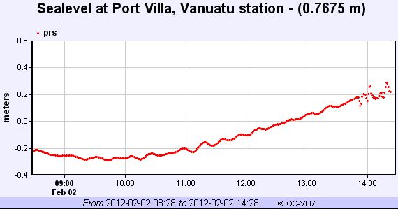
Tsunami
Earthquake Details
This event has been reviewed by a seismologist.
Magnitude
6.9
Date-Time
Thursday, February 02, 2012 at 13:34:38 UTC
Friday, February 03, 2012 at 12:34:38 AM at epicenter
Time of Earthquake in other Time Zones
Location
17.810?S, 167.149?E
Depth
10.1 km (6.3 miles)
Region
VANUATU
Distances
124 km (77 miles) W of PORT-VILA, Efate, Vanuatu
251 km (155 miles) S of Luganville, Espiritu Santo, Vanuatu
294 km (182 miles) NW of Isangel, Tanna, Vanuatu
1803 km (1120 miles) ENE of BRISBANE, Queensland, Australia
Location Uncertainty
horizontal +/- 15 km (9.3 miles); depth +/- 2.8 km (1.7 miles)
Parameters
NST=114, Nph=114, Dmin=477.6 km, Rmss=0.9 sec, Gp= 32?,
M-type=regional moment magnitude (Mw), Version=7
Source
Magnitude: USGS NEIC (WDCS-D)
Location: USGS NEIC (WDCS-D)
Event ID
usb0007uiv
Did you feel it? Report shaking and damage at your location. You can also view a map displaying accumulated data from your report and others.
Preliminary Earthquake Report
U.S. Geological Survey, National Earthquake Information Center:
World Data Center for Seismology, Denver
Comment