Check out the FAQ,Terms of Service & Disclaimers by clicking the
link. Please register
to be able to post. By viewing this site you are agreeing to our Terms of Service and Acknowledge our Disclaimers.
FluTrackers.com Inc. does not provide medical advice. Information on this web site is collected from various internet resources, and the FluTrackers board of directors makes no warranty to the safety, efficacy, correctness or completeness of the information posted on this site by any author or poster.
The information collated here is for instructional and/or discussion purposes only and is NOT intended to diagnose or treat any disease, illness, or other medical condition. Every individual reader or poster should seek advice from their personal physician/healthcare practitioner before considering or using any interventions that are discussed on this website.
By continuing to access this website you agree to consult your personal physican before using any interventions posted on this website, and you agree to hold harmless FluTrackers.com Inc., the board of directors, the members, and all authors and posters for any effects from use of any medication, supplement, vitamin or other substance, device, intervention, etc. mentioned in posts on this website, or other internet venues referenced in posts on this website.
We are not asking for any donations. Do not donate to any entity who says they are raising funds for us.
Magnitude 5.4 - ERITREA - ETHIOPIA REGION
2011 June 12 20:32:40 UTC
Magnitude 5.4
Date-Time
* Sunday, June 12, 2011 at 20:32:40 UTC
* Sunday, June 12, 2011 at 11:32:40 PM at epicenter
Location 13.441?N, 41.692?E
Depth 10 km (6.2 miles)
Region ERITREA - ETHIOPIA REGION
Distances
* 123 km (76 miles) WNW (294?) from Assab, Eritrea
* 207 km (129 miles) SW (222?) from Al Hudaydah, Yemen
* 241 km (150 miles) E (91?) from Mekele, Ethiopia
* 259 km (161 miles) NW (322?) from DJIBOUTI, Djibouti
Location Uncertainty horizontal +/- 16.7 km (10.4 miles); depth +/- 2.8 km (1.7 miles)
Parameters NST=113, Nph=113, Dmin=317.3 km, Rmss=1.17 sec, Gp= 50?,
M-type=regional moment magnitude (Mw), Version=6
Source
* U.S. Geological Survey, National Earthquake Information Center:
World Data Center for Seismology, Denver
Strong earthquakes are setting off a powerful volcanic eruption in Eritrea (based on satellite images)
Last update: June 13, 2011 at 12:50 am by By Armand Vervaeck and James Daniell 10 Comments
Earthquake / Eruption summary : During the late afternoon and evening of June 12 2011, a series of moderate earthquakes struck the Afambo, Eritrea area. The moderate earthquakes were followed by 2 strong 5.7 earthquakes. Based on the earthquake pattern and the locations of the epicenter, volcano activity seemed imminent.
UPDATE 13/06 ? 00:47 UTC : From now on we will have to wait for local reports, pictures, video?s etc.
We are very eager to get a confirmation that nobody was hurt and that no damage was inflicted during the earthquake and/or eruption.
Many scientists will board airplanes to take a close look at the volcano, take samples, etc.
UPDATE 13/06 ? 00:15 UTC : This is a very recent Google earth picture (combined with satellite cloud image). The size of the cloud is 150 km on 50 km! (91 on 35 miles)...
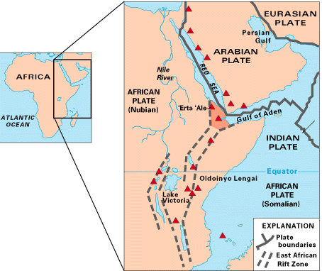
USGS: Map of East Africa showing some of the historically active volcanoes(red triangles) and the Afar Triangle (shaded, center) -- a so-called triple junction (or triple point), where three plates are pulling away from one another: the Arabian Plate, and the two parts of the African Plate (the Nubian and the Somalian) splitting along the East African Rift Zone.
"...there’s an obvious contest that’s happening between different sectors of the colonial ruling class in this country. And they would, if they could, lump us into their beef, their struggle." ---- Omali Yeshitela, African People’s Socialist Party
(My posts are not intended as advice or professional assessments of any kind.) Never forget Excalibur.
 Tweet
Tweet

Comment